
Northumberland Rocks: 23 walks
23 walks linked to sites in Ian Jackson’s Northumberland Rocks, with distances, route details and access notes. More walks will be added.

These walks visit geological sites from Ian Jackson’s Northumberland Rocks (Northern Heritage, 2021). There are 23 walks linked below, with another 27 places from the book still to add. They cover the historic county, including Newcastle and North Tyneside.
There’s a mix of short visits, coastal paths and longer hill walks. The distance shown is for the whole route. Check the walk page for the start, terrain and access details, and arrange return transport for the one-way routes.
Updated 1 November 2026.

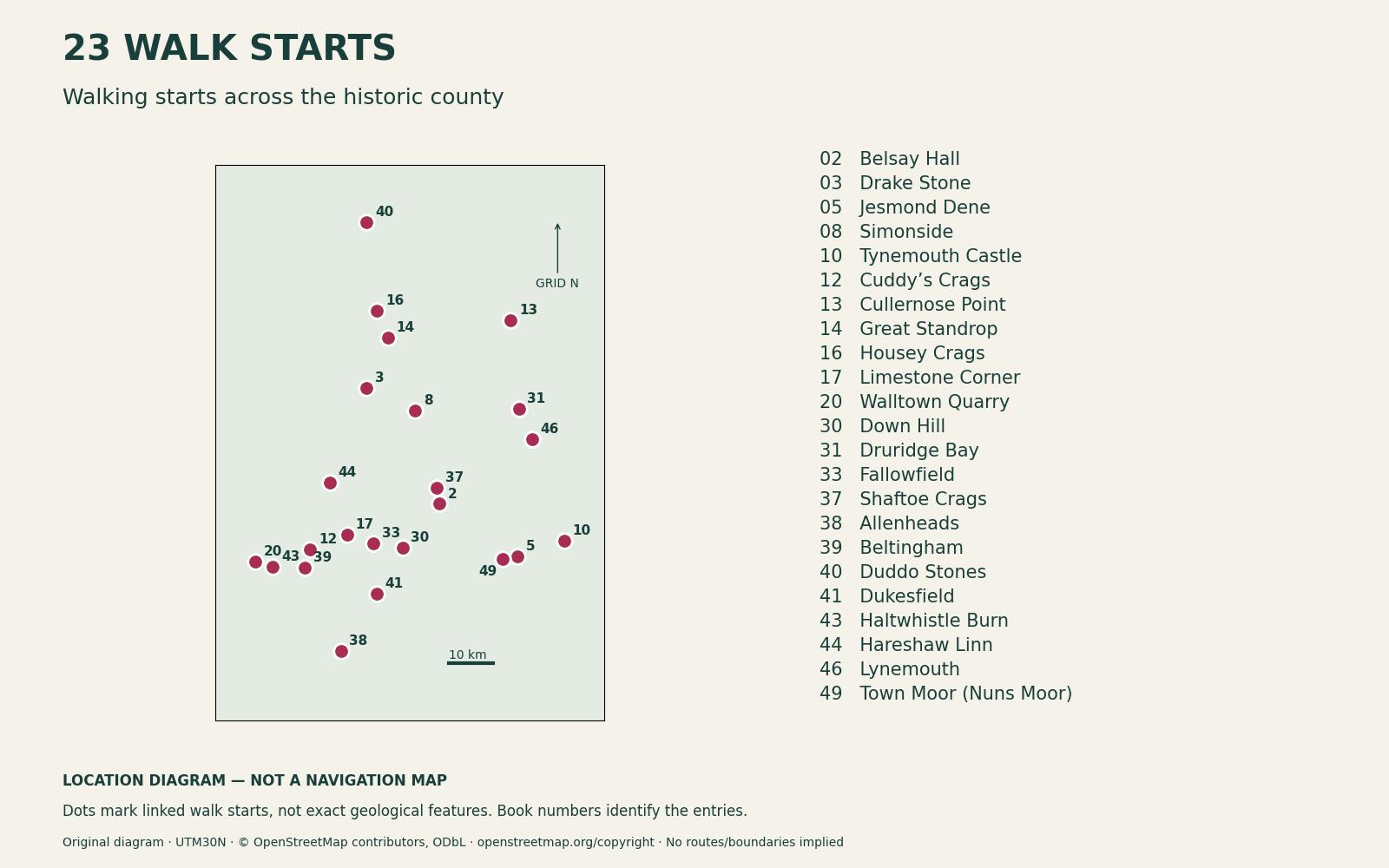
Locator key — walking starts, not rock locations: 2 Belsay Hall; 3 Drake Stone; 5 Jesmond Dene; 8 Simonside; 10 Tynemouth Castle; 12 Cuddy’s Crags; 13 Cullernose Point; 14 Great Standrop; 16 Housey Crags; 17 Limestone Corner; 20 Walltown Quarry; 30 Down Hill; 31 Druridge Bay; 33 Fallowfield; 37 Shaftoe Crags; 38 Allenheads; 39 Beltingham; 40 Duddo Stones; 41 Dukesfield; 43 Haltwhistle Burn; 44 Hareshaw Linn; 46 Lynemouth; 49 Town Moor (Nuns Moor). Scale: 10 km; arrow: grid north. Not for navigation. Enlarge the locator. © OpenStreetMap contributors, ODbL.

1. Drake Stone and Harbottle Lake
Book site 3 · 7.3 km · circular
The route climbs above Harbottle to the Drake Stone, a large sandstone boulder, then continues past the lake, woodland and Coquet valley. View the stone from the ground-level path; there’s no need to climb it.
Open the walk: The Drake Stone, Harbottle Lake and the Coquet
2. Simonside and Dove Crag
Book site 8 · 7.3 km · circular
Walk through the forest onto Simonside’s sandstone ridge, then continue towards Dove Crag before returning by forest paths and tracks. The upper section is exposed, and wind or low cloud can make it much harder than the sheltered start suggests.
Open the walk: Simonside Ridge and Dove Crag
3. Housey Crags and Hedgehope Hill
Book site 16 · 7.1 km · out and back
This route passes Housey Crags on the way to Hedgehope Hill. It’s a substantial hill walk on exposed ground, despite the relatively short distance. There’s no need to scramble onto the tor. Plan it without a pet dog; assistance-dog users should check the current official access directions.
Open the walk: Hedgehope Hill from Langleeford via Housey Crags
4. Great Standrop views from the Linhope route
Book site 14 · 11.9 km · out and back · Hard · allow about 6½ hours
The Linhope route to Hedgehope Hill includes a documented distant view towards Great Standrop. You can see the granitic tor in its wider setting, but this walk does not visit or climb it. The upper route is rough and exposed, and you need to be able to navigate.
Plan this outing without a pet dog unless current official directions expressly permit your intended route; assistance-dog users should check the applicable provisions.
Open the walk: Hedgehope Hill from Linhope
5. Shaftoe Crags and Bolam Lake
Book site 37 · 11.2 km · circular
This circuit takes in Bolam Lake, lanes, farmland and the sandstone crags at Shaftoe. It goes well beyond the lake paths and includes road walking. It covers the main crag landscape rather than every named formation.
Open the walk: Bolam Lake and Shaftoe Crags Walk: Circular Route
6. Walltown Quarry and Crags
Book site 20 · 2.7 km · out and back
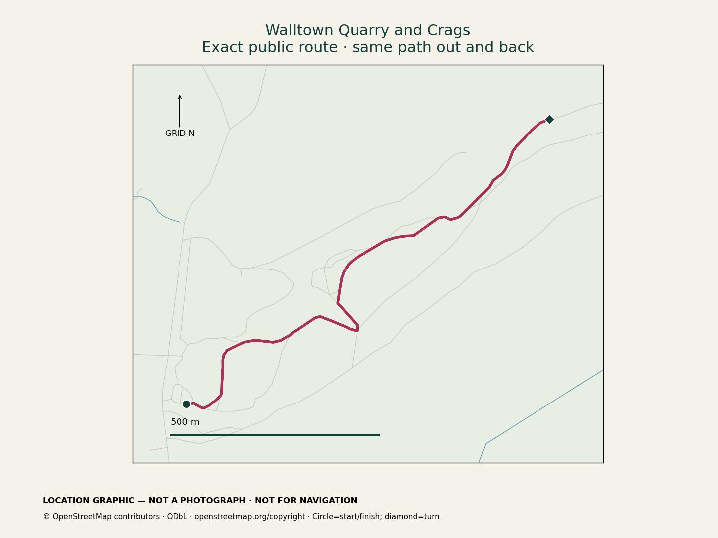
A short walk through the former dolerite quarry and up to the Whin Sill crags beneath Hadrian’s Wall. Return the same way through the restored quarry park. Keep to the paths and away from quarry faces.
Open the walk: Walltown Quarry and Crags: a short Whin Sill walk

Map key: circle = start and finish; diamond = turn. Return the same way. Scale: 500 m; arrow: grid north. Location guide, not for navigation.
Open the full-size Walltown graphic. Map data: © OpenStreetMap contributors, ODbL.
7. Cuddy’s Crags: Housesteads to Greenhead
Book site 12 · 16.9 km · one way
This Pennine Journey stage follows Hadrian’s Wall from Housesteads to Greenhead, including the Cuddy’s Crags crest. Allow a full walking day and arrange transport between the separate start and finish.
Open the walk: Housesteads car park to Greenhead: Hadrian’s Wall and the crags
8. Fallowfield: Heavenfield to Hexham
Book site 33 · 7.8 km · one way
The Way of Light route from Heavenfield to Hexham passes the sandstone slabs at Fallowfield, where glacial erosion has marked the rock. Visibility varies, so don’t disturb the surface to get a better look. This route visits the slab locality, not Fallowfield Mine.
Open the walk: Heavenfield to Hexham, the Way of Light
9. Cullernose Point from Craster
Book site 13 · 5.5 km · out and back
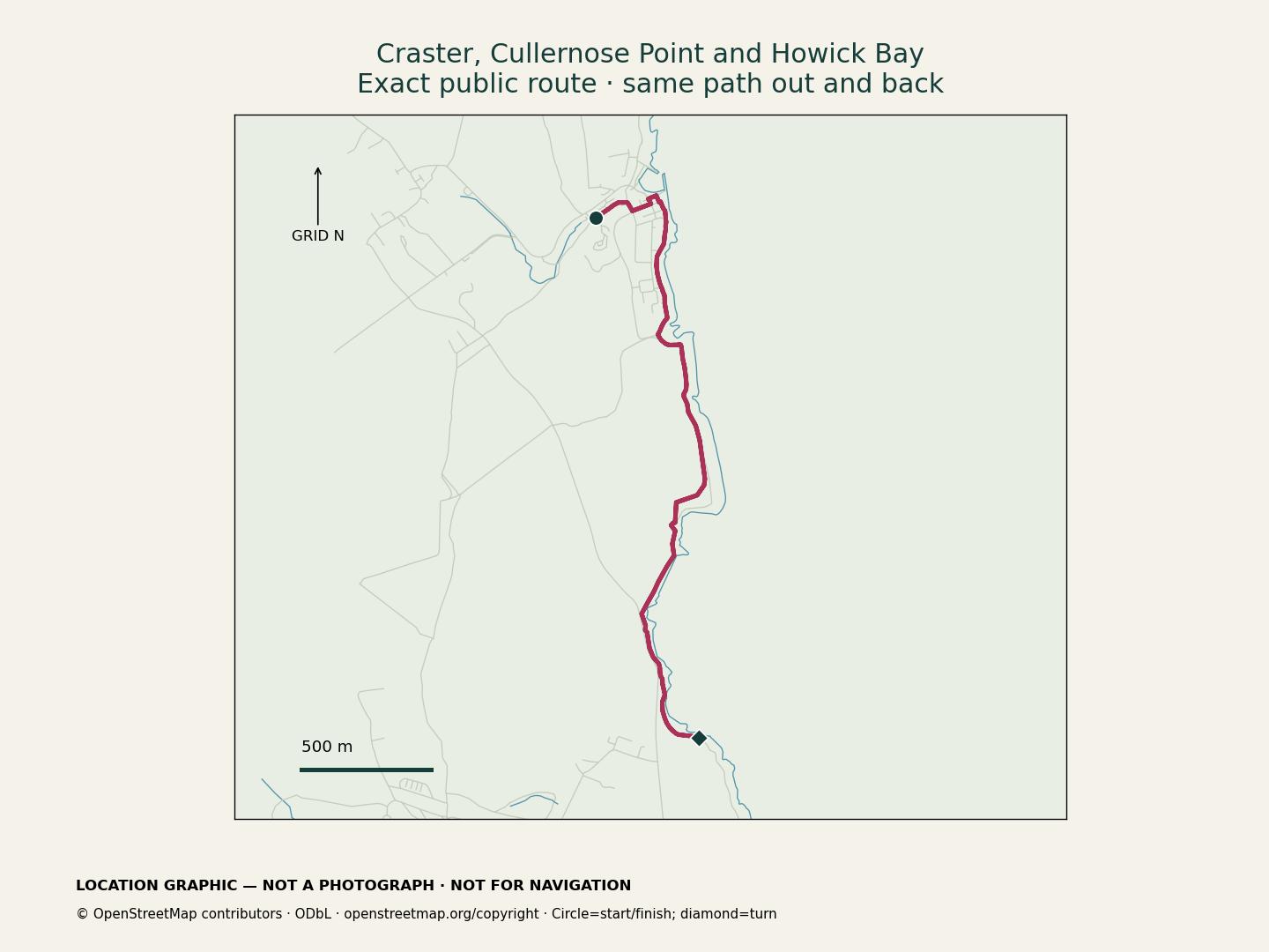
Follow the coast south from Craster to the dark crags at Cullernose Point, then continue towards Howick Bay and return. Stay on the coastal path. There’s no beach descent or promised close-up view of the separate Howick Fault exposure.
Open the walk: Craster, Cullernose Point and Howick Bay

Map key: circle = start and finish; diamond = turn. Return along the coastal path, with no beach descent. Scale: 500 m; arrow: grid north. Location guide, not for navigation.
Open the full-size coastal graphic. Map data: © OpenStreetMap contributors, ODbL.
10. Jesmond Dene and Armstrong Park
Book site 5 · 5.6 km · circular
The circuit follows Newcastle’s wooded sandstone and coal-bearing valley through Jesmond Dene and Armstrong Park. It includes the waterfall and traces of mills and Armstrong’s engineering. Expect steps, slopes and some unsurfaced paths.
Follow current park signs; closed bridges and streambeds are not shortcuts.
Open the walk: Jesmond Dene and Armstrong Park Circular
11. Duddo Stones
Book site 40 · 2.5 km · out and back
Follow the permissive farmland path to Duddo’s five sandstone standing stones. Allow time for the stone circle and interpretation board, then return the same way. Follow estate signs and check access restrictions before going.
Open the walk: Duddo Stones (Standing Stones)
12. Hareshaw Linn
Book site 44 · 4.7 km · out and back
Follow Hareshaw Burn through the wooded gorge to Hareshaw Linn. The visitor path crosses six footbridges and passes traces of Bellingham’s industrial history. Return the same way. Wet leaves, mud and stone can make the steps slippery; stop at the end of the maintained path.
Open the walk: Hareshaw Linn Waterfall
13. Haltwhistle Burn
Book site 43 · 2.9 km · out and back · Medium · allow about 75 minutes
Follow the wooded Burn path through sandstone and coal country, with remains of the industries that used them. Cross three mapped footbridges and turn on the path near Fell Chimney before returning. Don’t approach the ruin’s base. Vegetation and water levels affect what you can see.
The walk starts at the Willia Road path junction. Your approach is extra, and no designated parking is provided by this guide. Expect muddy or slippery ground and waterside edges; follow closure signs and turn back if high water or damage makes the path unsuitable.
Open the walk: Haltwhistle Burn, geology along the valley path
14. Tynemouth cliff walk
Book site 10 · 1.0 km · out and back · Easy · allow about 30 minutes
The upper-seafront pavement looks across King Edward’s Bay towards the headland beneath Tynemouth’s priory ruins. The cliffs contain Carboniferous and Permian rocks. This is a view across the bay; the route does not reach the dyke or shore exposures.
Stay on the pavement behind barriers, allowing for coastal wind and wet surfaces. Start at the East Street/Percy Street end; your approach is extra. No beach, pier or paid-attraction entrance is included.
Open the walk: Tynemouth cliff geology overlook
15. Druridge Bay dunes
Book site 31 · 3.1 km · out and back · Easy · allow about 70 minutes
Follow the landward trail beside Hadston Links, where wind and waves have built the dunes from moving sand. Turn at the junction before the Chevington Burn crossing and return. Stay off the fragile dune slopes. This route has no beach section and does not visit peat or old tree remains.
Your approach to the woodland-path start is extra. Use signed park paths, take care at the car-park access-road crossing and keep dogs on leads. Check country-park charges and gate-closing notices, and turn back if flooding or closures affect the trail.
Open the walk: Druridge Bay dunes walk
16. Allenheads heritage and woodland
Book site 38 · 0.9 km · out and back · Easy · allow about 30 minutes
This short route visits the exterior of Allenheads’ heritage buildings and the Hemmel, then follows nearby woodland paths. It uses two short arms, returning along each. The village developed around lead mining; the minerals formed in fractures in the rock.
Indoor displays are optional and depend on opening arrangements; the walk does not enter the old mineyard. Take care on the short village-road section—use the pavement where available rather than following the mapped road centreline. Your approach to the village-footway start is extra, and woodland paths can be muddy.
Open the walk: Allenheads heritage and woodland
17. Belsay quarry garden
Book site 2 · 1.2 km · out and back · Easy · allow about 35 minutes
Follow the main visitor path through Belsay’s quarry garden towards the castle, then return. Sandstone quarried here was used to build the hall. The route stays in the gardens and does not enter either building.
Admission is required. Enter through normal English Heritage admissions; applicable members may use their entitlement, and advance booking is optional. Check your chosen date’s opening and ticket details. The route begins inside the gardens, so the approach from admissions or parking is extra. Keep dogs on short leads, stay on visitor paths and follow works barriers; gravel and wet ground can be uneven or slippery.
Open the walk: Belsay quarry garden path
18. Nuns Moor avenue
Book site 49 · 1.3 km · out and back · Easy · allow about 30 minutes
Follow Nuns Moor’s tree-lined avenue and look across the grass for low mounds and hollows associated with shafts, spoil and subsidence. This is the mining landscape west of Grandstand Road. Stay on the avenue rather than walking into the old workings.
Start at the southern kissing gate and return from the grass-path junction before the northern end. The approach is extra, with no drive-up parking included. Share the path considerately, give grazing cattle space and follow current gate and closure notices.
Open the walk: Nuns Moor avenue
19. Dukesfield arches
Book site 41 · 0.5 km · out and back · Easy · allow about 20 minutes
The woodland track leads to the surviving arches of Dukesfield’s former lead-smelting mill. The site was part of the trade that carried products from the Pennine mines towards the Tyne. View the exterior from the track; don’t climb the masonry or enter the remains.
Begin at the road-track junction near Cragnook Well Bridge; your arrival is extra and parking has not been verified. There are no facilities at the arches. Expect uneven or muddy ground, and turn back rather than finding a stream-side bypass if the path is flooded or closed.
Open the walk: Dukesfield arches woodland walk
20. Snab Point to Lynemouth
Book site 46 · 4.0 km · out and back · Medium · allow about 90 minutes
Follow the landward paths south from Snab Point beside the Black Beach locality. Sea coal, moving sediment and industry have all shaped this coast. A particular coal deposit may not be visible. Turn before the southern road and River Lyne bridge approach and return the same way.
The route starts at the footpath junction beside the Snab Point parking aisle; your approach and any road crossing are extra. Grassy or overgrown sections can be uneven or slippery. There is no beach descent or river crossing: avoid older seaward branches, unstable edges and beach shortcuts, and leave any suspect debris undisturbed.
Open the walk: Snab Point to the Lynemouth coast path
21. Beltingham river gravels
Book site 39 · 0.6 km · out and back · Medium · allow about 20 minutes
This short woodland walk follows the South Tyne into Beltingham River Gravels reserve. Material washed down from Pennine mining areas helped create unusual habitats here. Stay on the woodland path to explore the riverside landscape; a particular gravel exposure or rare plant colony may not be visible.
Start at the path junction on the southern approach to Bardon Mill footbridge and return from the mapped junction about 280 metres into the reserve. Your approach, including any bridge crossing, is extra. Keep dogs on leads and avoid the riverbank and sensitive grassland. Roots, mud, fallen trees and flooding can affect the path; turn back if it is obstructed or closed.
Open the walk: Beltingham river-gravel walk
22. Limestone Corner
Book site 17 · 0.9 km · out and back · Medium · allow about 35 minutes
Despite the name, the hard rock at Limestone Corner is Whin Sill dolerite. From Hadrian’s Wall Path, look at the unfinished Roman ditch where cutting through that rock proved difficult. Stay on the Trail rather than entering the ditch or climbing the blocks.
This short excursion is for walkers already on Hadrian’s Wall Path. The approach to its eastern ladder-stile start is extra; it is not a drive-up trailhead. There are stiles, uneven grass and possible mud. Keep dogs under close control around livestock, follow current signs and do not use the B6318 verge as an approach. Detailed tool marks are not promised from the path.
Open the walk: Limestone Corner on Hadrian’s Wall Path
23. Down Hill
Book site 30 · 0.8 km · out and back · Medium · allow about 30 minutes
The wooded rise at Down Hill is a large raft of Great Limestone moved by ice. Follow Hadrian’s Wall Path along its southern side to see the hill’s shape and scale, then return from the eastern path bend. Trees and vegetation may hide the rock; this is not a visit to an exposed quarry face.
This is another short excursion for walkers already on the Trail. Your approach to the western boundary gate is extra, with no drive-up parking or facilities included. Stay on the grassy path, keep dogs under close control around livestock and follow local signs. Do not enter the woodland or quarry, cross fences or improvise an A68 or B6318 verge approach.
Open the walk: Down Hill geology excursion
Choosing a walk

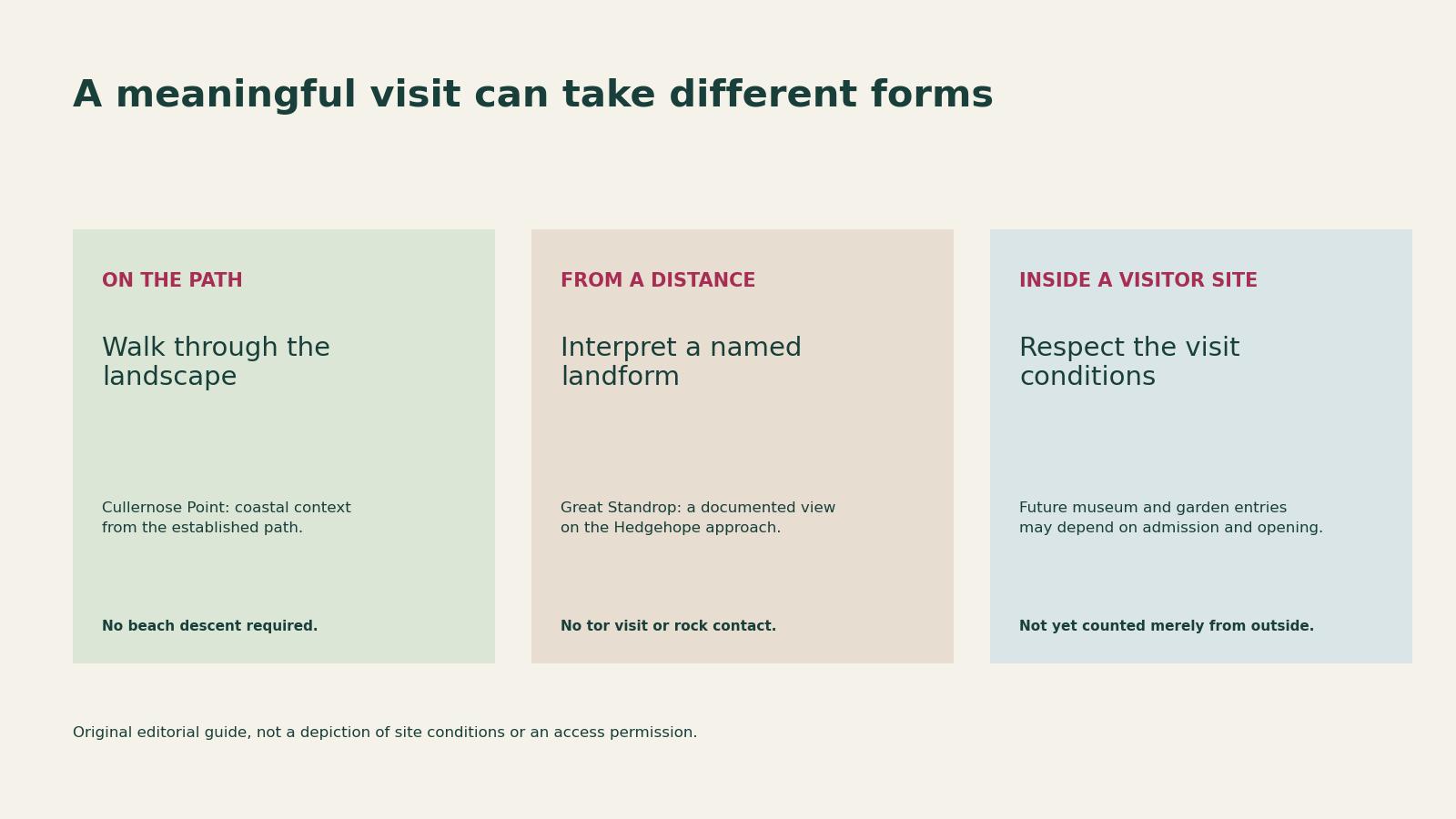
- On the path: Cullernose Point provides coastal landscape context from the established path, without a beach descent.
- From a distance: Great Standrop is interpreted from a documented view on the Hedgehope approach, not by visiting or touching the tor.
- Inside a visitor site: make time to go inside a museum or garden, checking admission and opening times first. Belsay’s quarry garden requires admission.
More places to explore next
The remaining 27 places are listed below by book number. We’ll add their walking links as they’re ready.
1. Akenshaw Burn · 4. Green Carts Quarry · 6. Kielder Stone · 7. Queen’s Crag · 9. Sugar Sands Bay · 11. Coquet valley · 15. Holy Island
18. Linhope Spout · 19. Lumsden Law · 21. Berwick · 22. Coquet Head · 23. Crindledykes · 24. Cullercoats · 25. Howick Haven · 26. Saltpan Rocks · 27. Beldon Cleggh · 28. Bradford Kame
29. Broomlee Lough · 32. Echo Crags · 34. Falstone Moss · 35. Gelt Linn · 36. Hauxley
42. Hancock Museum · 45. Hartley New Pit · 47. Newcastle upon Tyne · 48. The Spetchells · 50. Woodhorn Museum
The list retains the book’s site names. “Beldon Cleggh” is also encountered geographically as Beldon Cleugh. Some neighbouring places may share a walk.
Before you go
- Read the individual route, including its actual starting point and whether you must arrange return transport.
- Check current manager notices, closures and any admission or seasonal opening arrangements. A route being online does not mean every path is open today.
- On the coast, stay behind barriers and away from cliff bases. Do not add an unplanned tidal excursion to a landward walk.
- In the hills, allow for wind, cloud, wet ground and navigation. Check local dog restrictions rather than assuming that a lead makes access permissible.
- Leave rocks, fossils, archaeological remains and sensitive vegetation undisturbed. Observe from established, permitted paths and turn back when conditions or closures make the planned route unsuitable.
Further reading
Inspired by Ian Jackson, Northumberland Rocks (Northern Heritage, 2021). Use the book for more about the sites and the linked walks for route details. This is an independent Walkmates guide, not an author or publisher endorsement.
For more geological background, explore the book’s contents, the BGS Northumberland geodiversity audit and the JNCC account of the Cheviot tors.
We’ll keep adding walks here. Before each outing, check the route page and current local notices: paths, weather and access can change.
Keep reading
Related walking guides

Shaftoe Crags walk: choosing a start point and checking the route
Plan a Shaftoe Crags walk: compare Bolam Lake and Westwood starts, published circuits, parking, access and the shorter lakeside alternative.
Read route guideFive Northumberland hill walks for crags, history and big views
Compare five Northumberland hill walks, including Simonside, Hedgehope and The Cheviot, with route links, historic landmarks and planning advice.
Read route guideFive Northumberland walks for woodland, waterfalls and wildlife
Explore five Northumberland walks at Plessey Woods, Hareshaw Linn, Linhope Spout, Wallington and Hauxley, with route links and practical planning notes.
Read route guide