

Rhossili Down - The Beacon
Good walks are even better shared.
SS4288 : Track on Rhossili Down
David Smith Photo source
Overview
The Beacon is the 193 m summit of Rhossili Down, the highest point on Gower, above Rhossili Bay. A trig pillar stands beside the natural summit rock. Steep heathland paths lead from Rhossili village or Hillend, with views towards Worm's Head and longer circuits returning by the inland coast path or the beach.
Rhossili Down - The Beacon
The Beacon is the 193 m summit of Rhossili Down and the highest point on Gower. Its prominence is 145 m. An OS trig pillar marks the summit area; the Database of British and Irish Hills identifies a small rock beside it as the natural high point. The hill is a Hump. Its former Submarilyn designation was removed in May 2025 after the list definition changed.
Landscape and views
The Down rises behind Rhossili Bay, with a ridge of open heathland above the beach. Devonian sandstone and conglomerate form the high ground. The limestone cliffs around the village and Worm's Head belong to the neighbouring coastal landscape. Below the western scarp, the broad terrace was formed by material moving downslope under cold-climate conditions.
Views take in Rhossili Bay and Worm's Head. In clear weather the wider outlook includes west Wales, Lundy and the north Devon coast. Heather brings colour in late summer and early autumn; visibility and weather matter more than the season for distant views.
Summit and history
The trig pillar stands on a damaged cairn interpreted as a Bronze Age burial monument. The wider Down also contains the Sweynes Howes burial chambers and the concrete remains of a Second World War radar station, used between 1942 and 1945. Leave archaeological stonework undisturbed.
Choosing a route
The 6.5 km Walking Britain circuit takes the ridge to the Hillend area and returns along the Wales Coast Path above the beach. Its published figures are 212 m ascent and 2.5 hours for the whole walk.
The National Trust's 8 km, 2.5-hour circuit returns from Hillend along the beach and climbs steep steps back to Rhossili. That beach leg requires a tide and sea-condition check. The inland coast path offers a different return.
For a shorter summit outing, turn back at The Beacon and descend by the same southern path. A traverse from Hillend to Rhossili is one-way and needs an onward travel plan. The headland viewpoint at the NCI lookout can be visited separately or after returning to the village; it does not require crossing onto Worm's Head.
Access and facilities
Use the National Trust car park in Rhossili village. Parking is charged; follow the current payment instructions. Toilets are between the car park and National Trust shop, with accessible facilities at the car park. Village cafés and a pub provide refreshments, subject to opening hours.
Adventure Travel's 118 links Swansea and Rhossili. Check the current timetable and return journey before setting out, including any day-of-week or seasonal restrictions.
Safety
Expect steep paths, uneven ground and wet or boggy heath. Carry a map and suitable clothing: a low coastal hill can still be exposed to wind and poor visibility. Keep away from cliff edges and from the base of loose coastal cliffs.
Livestock graze in the area, including cattle and ponies on the headland. Give animals room, keep dogs close and use a short lead around livestock. If cattle threaten you and your dog, release the lead so you can move to safety separately. Follow local signs and protect ground-nesting birds.
Worm's Head is a tidal island, separate from The Beacon. Check the crossing times displayed by the causeway and seek advice from NCI Worms Head before attempting it. Plan the whole outward and return journey within the available window; a generic low-tide rule is not a substitute for local advice. If cut off, do not swim or wade back. Call 999 and ask for the Coastguard.
Explore routes near Rhossili Down - The Beacon
Walks starting near this hill. Open a route to check its map, distance and full itinerary.
Gower winter wildlife and birdwatching walk
View route
Llanelli North Dock to Machynys Point and Wetland Centre
View route
Llanelli North Dock to Burry Port Harbour Coastal Walk
View route
Llanelli warden-led wildlife walk
View route
Route planning notes
These notes describe possible approaches. Check a route's map and access information when planning your walk.
Rhossili Down circular via the Wales Coast Path
Start and finish at Rhossili's seafront car park (SS415879). Pass the church, climb to The Beacon, then continue north along the ridge past the radar-station remains. Before Hillend, turn left onto the Wales Coast Path and return above the beach, then past the church to the car park. Walking Britain gives 212 m ascent for this complete circuit. Its beach-return alternative is a different, tide-dependent choice.
Rhossili Down ridge: Hillend to Rhossili, one way
From Hillend, climb the steep northern approach and follow the ridge south, passing the radar-station remains and reaching The Beacon. Descend by the southern path to the gate above St Mary's Church, then continue into Rhossili. This reverses the ridge section of the published circuits. It ends in Rhossili; arrange onward transport rather than expecting a circuit back to Hillend.
Rhossili Down, Hillend and beach circular
Start and finish at the National Trust car park/shop in Rhossili (SS414881). Climb via the church to The Beacon, follow the ridge past the radar-station remains and descend to Hillend. Return south along Rhossili beach, then climb the steep steps to the village and car park. The National Trust's 8 km and 2.5 hours cover this entire circuit. Check tides and sea conditions before committing to the beach; use the inland coast-path return if the beach is unsafe.
The Beacon from Rhossili, out and back
From Rhossili village car park, take the church approach and climb the southern path to The Beacon. Return by the same path to the church and car park. This is the summit section of the longer circuits, shortened by turning back at the top. The descent is steep; take care on wet or loose ground.
The Beacon and Worm's Head mainland viewpoint
From Rhossili village car park, climb to The Beacon via the church and return the same way to the village. Continue past the National Trust shop along the headland path to the NCI lookout for the Worm's Head view, then retrace the headland path to the car park. This combined outing stays on the mainland. Crossing the tidal causeway onto Worm's Head is a separate undertaking requiring the day's posted crossing times and enough time to return before closure.
Make a day of it, together
Find someone to share the walk with, or organise a day out along a route you like.
Photo Gallery
View all Photo could not load
SS4288 : Track on Rhossili Down
David Smith
 Photo could not load
SS4188 : Path to The Beacon
Bill Boaden
 Photo could not load
SS4288 : Bryn Rhossili Down
Alan Richards
 Photo could not load
SS4288 : The Beacon
Philip Halling
 Photo could not load
SS4288 : Summit trig on Rhossili Down
Richard Law
 Photo could not load
SS4288 : View from The Beacon to Worms Head
John Light
 Photo could not load
SS4288 : Trig Point, The Beacon
Pierre Terre
 Photo could not load
SS4288 : The trig pillar on Rhossili Down
David Smith
 Photo could not load
SS4188 : Rhossili Bay from The Beacon Trig Point
John Light

SS4188 : Trig point on The Beacon
Bill Boaden
Hill facts and local notes
Classifications
Elevation
193m
633 ft
Prominence
145m
Coordinates
51.5764, -4.2816
SS419888
OS Map
159
Explorer: 164
At the Summit
An OS trig pillar on a damaged prehistoric cairn. The recorded natural high point is a small protruding rock beside the pillar, at 193 m.
Terrain & Geology
Rhossili Down is formed from Devonian sandstone and conglomerate. The limestone cliffs around Rhossili village and Worm’s Head are part of the adjacent coastal landscape. A broad solifluction terrace below the Down records cold-climate movement of loose material down its western slope.
Views & Scenery
Views over Rhossili Bay and Worm's Head, with wider views across Gower and, in clear conditions, towards west Wales, Lundy and the north Devon coast.
Best Seasons
Heathland flowers bring pink and purple colour in late summer and early autumn. Distant sea views depend on clear weather.
History & Heritage
Historical Significance
The summit cairn is a scheduled monument interpreted as a Bronze Age burial feature; its remains were disturbed by installation of the OS pillar. Sweynes Howes are separate prehistoric burial chambers on the Down. The ridge also has the concrete remains of a radar station used by the Army and RAF from 1942 to 1945.
Getting There & Facilities
Parking
National Trust car park in Rhossili village, beside the main visitor facilities. Charges apply; follow current signs and payment instructions. National Trust members should follow the current membership check-in process. Overnight parking and camping are not permitted.
Public Transport
Adventure Travel service 118 connects Swansea and Rhossili. Check the current operator timetable for your travel date and the last return bus; do not assume a daily or year-round Sunday service. Rail passengers can travel via Swansea station and the city bus station.
Nearby Facilities
Toilets are between the Rhossili car park and National Trust shop; accessible toilets and a Changing Places facility are at the car park. The village has cafés and a pub. Check opening times and carry water for the hill.
Safety Information
Known Hazards
- Steep, uneven hill paths and boggy heath; wet ground reduces grip, particularly on descents.
- Exposed ridge and coastal paths in strong winds or poor visibility; carry navigation and weather protection.
- Cliff edges and loose coastal cliffs: keep well back from edges and avoid lingering below unstable faces.
- Beach returns depend on tides and sea conditions. Check the return route before descending to the shore.
- Livestock graze throughout the year. Keep dogs on a short lead around animals; if cattle threaten you and your dog, release the lead and move away.
- Worm's Head is a separate tidal crossing. Use the posted crossing times and allow for the entire return. Never swim or wade back if cut off; call 999 and ask for the Coastguard.
Seasonal Hazards
Rain can leave steep paths slippery and wet heath boggy. Coastal storms and poor visibility increase exposure. Livestock are present year-round; keep dogs controlled and follow seasonal wildlife notices.
General Safety Tips
- Check weather conditions before setting out
- Carry appropriate clothing and equipment
- Let someone know your planned route
- Take a map, compass, and GPS device
- Carry emergency supplies: food, water, first aid kit, torch
Hills
Some common questions about the hills answered
Are there group walks up Rhossili Down - The Beacon?
Many walkers use Walkmates to join or organise walks with others. You can check for group walks around Rhossili Down - The Beacon through the maps
Are there other walkers around Rhossili Down - The Beacon?
Activity varies by location and time, but Walkmates lets you see whether others have shared walks or shown interest in this area. Find other people through the walking friends search walking friends for Rhossili Down - The Beacon search or of course create your own walk for Rhossili Down - The Beacon
Can I organise a walk to Rhossili Down - The Beacon?
Yes. If there aren’t any walks listed already, you can create a walk and make it available for others to join.
If you're signed up to Walkmates, you can create a walk to Rhossili Down - The Beacon.
How do I find a walk up this hill?
There are often multiple ways to walk this hill, depending on experience and route preference. Walkmates helps you explore walks and routes that others have shared.
Can I suggest a new route up Rhossili Down - The Beacon?
Yes. You can suggest or create routes to share with others. Walkmates focuses on the social side of walking, so routes are used to help people organise walks and explore areas together, rather than as detailed navigation tools or route libraries.
Other uses really appreciate knowledgeable walkers sharing their routes. Share your favourite route to Rhossili Down - The Beacon here
The is an error or something incorrect about this hill. How do I let you know?
We always strive to keep the information on Walkmates as accurate as possible. If you find an error, please let us know through the contact form and we'll aim to correct it as quickly as possible
Community Discussion
Comments
Location
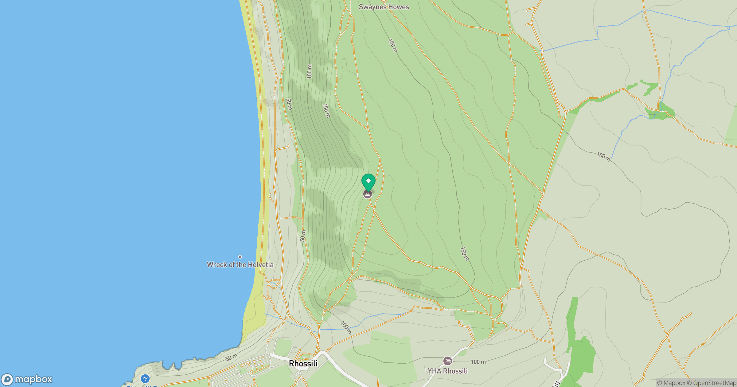
Grid reference: SS419888
View on OpenStreetMapOpens a map in a new tab, centred on the hill.
Nearby Hills
Fan Brycheiniog - Twr y Fan Foel
802m
Fan Gyhirych
726m
Pen y Fan
142m
Dunkery Beacon
520m
Pen y Fan
886m
No comments yet. Be the first.