

Kilvey Hill
Good walks are even better shared.
Overview
Kilvey Hill: A Gem of South Wales
Nestled in South Wales, Kilvey Hill offers an unbeatable blend of stunning views and rich history. Standing at 192 meters tall, this Marilyn is a perfect destination for a day hike, whether you're an experienced walker or just looking for a lovely stroll.
Geology
Kilvey Hill's geology is fascinating, composed mainly of limestone and sandstone that tell the story of an ancient marine environment. Look closely, and you might just spot some fossilised remains, so keep your eyes peeled — each step could reveal a slice of history!
The Routes
The Kilvey Hill Circular Walk is a moderate 3.5 km loop starting from Kilvey Hill Road. This trail leads you through a variety of terrains — muddy patches, rocky paths, and clear trails, making it ideal for those who enjoy a little adventure.
Summit Features
At the summit, you’ll find a well-marked trig point. It’s the perfect photo op, so you can let your friends know you’ve conquered Kilvey Hill! Enjoy a well-deserved rest here, taking in the beautiful scenery that stretches out before you.
Terrain
Expect a mixed bag when it comes to terrain. You’ll navigate well-defined paths, rocky sections, and some uneven ground. Just remember to tread carefully, especially when mother nature has decided to turn on the wet weather tap!
Views
The views from Kilvey Hill are simply marvellous. Gaze upon Swansea Bay, the lovely Gower Peninsula, and on clear days, catch a glimpse of the majestic Brecon Beacons. The best time to take in these sights? Spring and autumn, when the scenery shines bright and clear!
Hazards
When hiking Kilvey Hill, keep in mind that conditions can change. Loose rocks and muddy trails can present challenges, especially during wetter seasons. Always take care to watch your footing and prepare for changing weather conditions.
Nearby Summits
If you’re still up for more adventure, consider visiting nearby Mynydd Maen (243 m) or Mynydd y Gwrhyd (358 m) for additional hikes that won’t disappoint.
Access and Parking
For those driving, there’s limited parking available near Kilvey Hill Road. If you're planning to visit on weekends, arriving early is your best bet. Public transport options include local buses that run from Swansea's main roads.
Facilities
Stop by Swansea for nearby cafes and shops — perfect for refuelling after your hike or grabbing some last-minute supplies!
History
The name 'Kilvey' likely derives from the Welsh 'Cil-fyw', meaning 'the narrow place between the waters', hinting at the hill’s scenic location adjacent to the River Tawe.
Kilvey Hill is not just a hike; it’s a slice of the vibrance of South Wales, wrapped in stunning views, rich geology, and cultural significance. Pack your walking boots, grab a snack, and head out for a memorable day!
Explore routes near Kilvey Hill
Public walks starting within 80 km of this hill. Nearby does not mean a route reaches the summit; check its map and access before setting out.
Swansea Marina to Mumbles Pier approach
View route
Swansea Clyne Valley Railway Walk: Blackpill to Dunvant
View route
Swansea Canal: Coed Gwilym Park to Pontardawe Aqueduct
View route
Llanelli warden-led wildlife walk
View route
Route planning notes
These notes describe possible approaches, not verified navigable routes or permission to cross land. Check current paths, local access rules and conditions before setting out.
Kilvey Hill Circular Walk
A loop starting from the base of the hill, offering a gradual ascent and a chance to experience varied terrains and local wildlife.
Make a day of it, together
Find someone to share the walk with, or organise a day out along a route you like.
Photo Gallery
View all Photo could not load
SS6793 : The south side of Kilvey Hill
Bill Boaden
 Photo could not load
SS6793 : Windmill Ruin on Kilvey Hill
Nigel Davies
 Photo could not load
SS6793 : Wall fragment at remains of Kilvey Hill Windmill
Nigel Davies
 Photo could not load
SS6794 : Ordnance Survey Rivet
Adrian Dust
 Photo could not load
SS6793 : Path up to Kilvey Hill
Bill Boaden
 Photo could not load
SS6793 : Scrub on Kilvey Hill
Bill Boaden
 Photo could not load
SS6793 : Summit Shelter on Kilvey Hill
Nigel Davies
 Photo could not load
SS6794 : Path on Kilvey Hill
Bill Boaden
 Photo could not load
SS6794 : Transmitter Masts on Kilvey Hill
Nigel Davies
 Photo could not load
SS6794 : Kilvey Hill
Rude Health
Hill facts and local notes
Classifications
Elevation
193m
633 ft
Prominence
140m
Coordinates
51.6293, -3.9211
SS671940
OS Map
159
Explorer: 165
At the Summit
At the summit, you’ll be greeted by a prominent trig point, which is essentially a fancy way of saying, 'I’ve made it to the top!' There's also ample space to rest while enjoying the views.
Terrain & Geology
Kilvey Hill is primarily composed of limestone and sandstone, with fascinating fossilised remains that provide a glimpse into the area's geological history. It's a classic example of South Wales' rich geological diversity.
Views & Scenery
From the summit, you can see the stunning Swansea Bay, the Gower Peninsula, and on a clear day, even the Brecon Beacons in the distance. A sight that can leave you breathless, but in a good way.
History & Heritage
Name Origin
The name 'Kilvey' is believed to have originated from the Welsh 'Cil-fyw', which means 'the narrow place between the waters', hinting at its location near the River Tawe.
Historical Significance
Kilvey Hill has historically served as a landmark for navigation and offers cultural significance as a spot steeped in local lore. It's a great place for both local hikers and history enthusiasts.
Getting There & Facilities
Check current local access restrictions, parking rules and transport timetables before travelling. These notes do not confirm public access to the summit.
Parking
There is limited parking available at the base of the hill near Kilvey Hill Road, but be sure to arrive early during weekends to secure a spot.
Public Transport
The nearest bus stops are located on the main roads leading into Swansea, with local buses providing access to Kilvey Hill.
Nearby Facilities
Near the base of Kilvey Hill, you can find a few cafes and shops in Swansea city centre, perfect for a pre- or post-hike bite or a toilet stop.
Safety Information
Known Hazards
- While the paths are generally safe, loose rocks and wet conditions can make for a tricky footing. Always keep an eye out for changing weather.
General Safety Tips
- Check weather conditions before setting out
- Carry appropriate clothing and equipment
- Let someone know your planned route
- Take a map, compass, and GPS device
- Carry emergency supplies: food, water, first aid kit, torch
Hills
Some common questions about the hills answered
Are there group walks up Kilvey Hill?
Many walkers use Walkmates to join or organise walks with others. You can check for group walks around Kilvey Hill through the maps
Are there other walkers around Kilvey Hill?
Activity varies by location and time, but Walkmates lets you see whether others have shared walks or shown interest in this area. Find other people through the walking friends search walking friends for Kilvey Hill search or of course create your own walk for Kilvey Hill
Can I organise a walk to Kilvey Hill?
Yes. If there aren’t any walks listed already, you can create a walk and make it available for others to join.
If you're signed up to Walkmates, you can create a walk to Kilvey Hill.
How do I find a walk up this hill?
There are often multiple ways to walk this hill, depending on experience and route preference. Walkmates helps you explore walks and routes that others have shared.
Can I suggest a new route up Kilvey Hill?
Yes. You can suggest or create routes to share with others. Walkmates focuses on the social side of walking, so routes are used to help people organise walks and explore areas together, rather than as detailed navigation tools or route libraries.
Other uses really appreciate knowledgeable walkers sharing their routes. Share your favourite route to Kilvey Hill here
The is an error or something incorrect about this hill. How do I let you know?
We always strive to keep the information on Walkmates as accurate as possible. If you find an error, please let us know through the contact form and we'll aim to correct it as quickly as possible
Community Discussion
Comments
Location
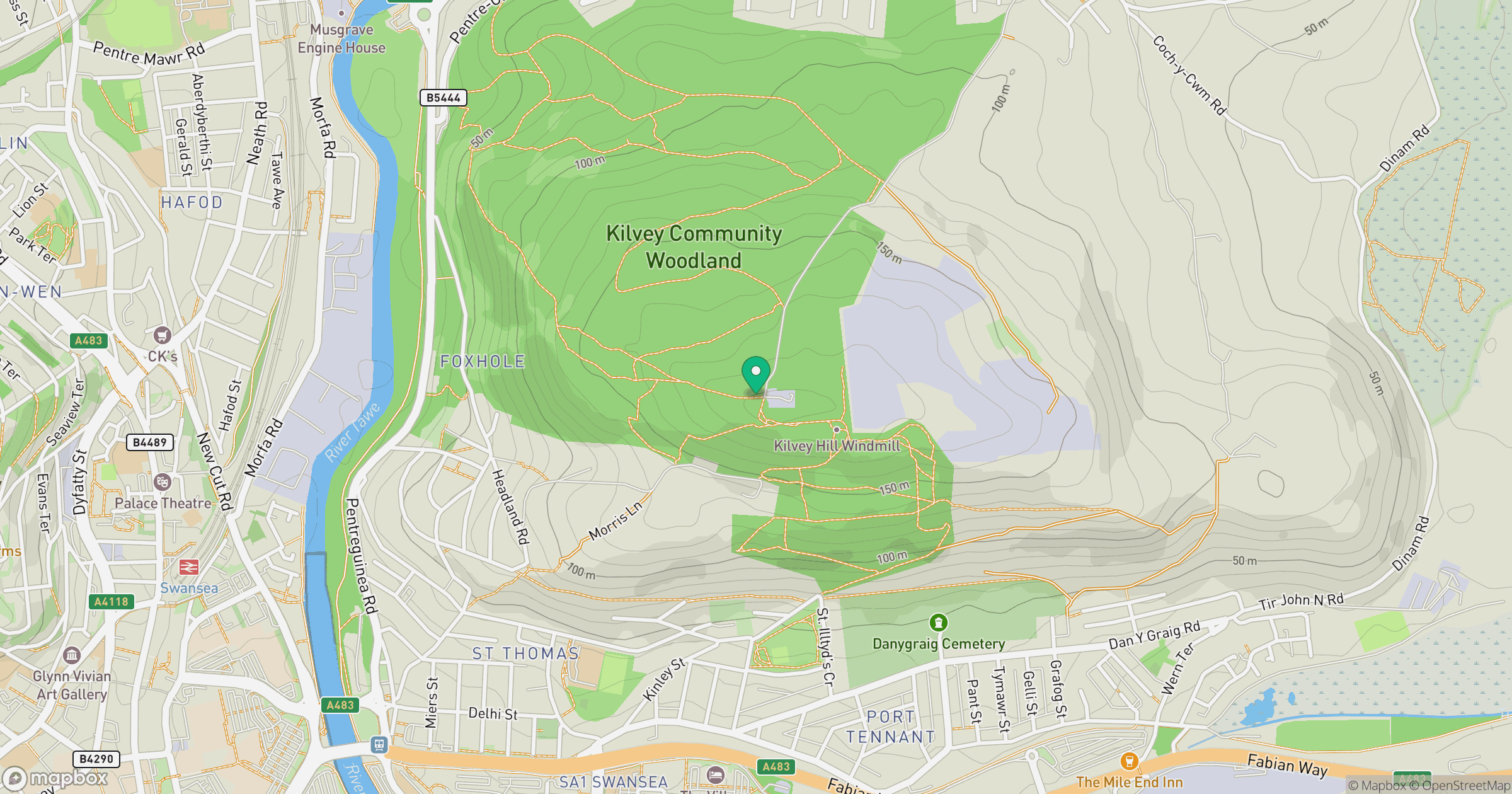
Grid reference: SS671940
View on OpenStreetMapOpens a map in a new tab, centred on the hill.
Hills within 30 km
Straight-line distance, not a walking route or confirmation of access.
Rhossili Down - The Beacon
193m
Mynydd Drumau
272m
Mynydd Dinas
258m
Mynydd y Betws
373m
Mynydd Uchaf
357m
No comments yet. Be the first.