
Crockbrack
Good walks are even better shared.
Overview
Crockbrack: A Hill Worth Climbing
Introduction
Nestled in the serene landscapes of Northern Ireland, Crockbrack is a hidden gem for hikers and outdoor enthusiasts alike. Standing at an elevation of 405 meters, this Marilyn offers an excellent challenge for both novice and seasoned walkers, with the promise of breathtaking views and a touch of local history.
Geology
Crockbrack's geological features reveal a predominantly limestone composition, dotted with sandstone formations that tell tales of ancient seas and shifting landscapes. The area’s unique geology not only shapes the terrain but also supports a diverse ecosystem of flora and fauna.
Routes
The most popular route is the Crockbrack Hill Circular, a 5 km trail that winds up and around the hill, taking an estimated 2 hours to complete. With a moderate difficulty level, this route is ideal for families and casual hikers looking to soak in the beauty of the outdoors without breaking a sweat. Just remember, it’ll be a much more pleasant stroll if the wellies don’t get bogged down!
Summit Features
The summit is crowned by a cairn that serves as both a landmark and a perfect resting point for weary hikers. There’s something deeply satisfying about plopping down at the top of a hill and surveying the world below—a natural therapy session without the need for a couch.
Terrain Type
Expect grassy trails interspersed with rocky outcrops and the potential for a bit of bogginess, especially after a generous downpour. Thus, hiking boots are always a wise choice.
Views
As for the views? They’re nothing short of spectacular! You’ll get a panoramic perspective of the Mourne Mountains to the east and a sweeping sight of the patchwork of fields that define the local landscape. The best seasons to visit are spring and early autumn, when the skies are clear and the colours are vibrant, energetically declaring that nature knows how to throw a good party!
Hazards
While the path offers a delightful outing, it’s essential to be cautious of sudden weather changes—one moment you might be basking in sunshine, and the next, you could be caught in a downpour. Also, take care on slippery rocks when the ground is wet. When it rains, it pours, but let’s keep that metaphorical!
Nearby Summits
If you’re keen on a mini-circuit, consider the Cranmore Hill and Slieve Croob nearby, both offering their unique charm and challenges for the enthusiast.
Access
For those driving out, there is plenty of parking at the base of the trail, conveniently located along the B6 road. Unfortunately, public transport is not exactly frequent, so your best bet is to grab a taxi or set off in your own vehicle. Dromara, the nearest village, is merely 6 km away and provides charming options for a post-hike pint.
Facilities
Before or after your adventure, pop into one of the few delightful cafes or shops in Dromara where you can refuel with treats and beverages. You’ll need the energy for all those uphill walks!
History
The name Crockbrack means 'speckled hill' in Irish—an apt description for this magnificent mound that influences local mythology and harbours the whispers of the past. Its cultural significance adds to the allure of hiking it, enriching the experience.
In conclusion, whether you’re seeking exploration, a photographic quest, or simply a bit of peace and quiet atop a hill, Crockbrack has it all. Just remember to pack a sandwich and leave your worries at the foot of the hill! Enjoy your hike!
Explore routes near Crockbrack
Public walks starting within 80 km of this hill. Nearby does not mean a route reaches the summit; check its map and access before setting out.
Banagher Glen and Forest: complete higher-return circuit
View route
Derry~Londonderry City Walls Circuit
View route
Peatlands Park Red Trail: Annagarriff Wood and Derryadd Lough
View route
Portballintrae to Giant's Causeway: railway path and Blue Trail return
View route
Route planning notes
These notes describe possible approaches, not verified navigable routes or permission to cross land. Check current paths, local access rules and conditions before setting out.
Crockbrack Hill Circular
A scenic circular route that takes you up and around Crockbrack, offering panoramic views of the surrounding countryside.
Make a day of it, together
Find someone to share the walk with, or organise a day out along a route you like.
Hill facts and local notes
Classifications
Elevation
526m
1,726 ft
Prominence
148m
Coordinates
54.8045, -6.8858
H716957
OS Map
13
At the Summit
The summit of Crockbrack features a prominent cairn that can be easily spotted from a distance, providing a perfect spot for a summit selfie.
Terrain & Geology
Crockbrack is predominantly composed of limestone with some sandstone formations, providing a unique insight into the geological history of the area.
Views & Scenery
From the summit, a stunning vista includes the Mourne Mountains to the east and the expansive views of the surrounding countryside.
History & Heritage
Name Origin
The name Crockbrack comes from the Irish 'Cnoc Brack', meaning 'speckled hill', possibly referring to the limestone landscape and its unique markings.
Historical Significance
Crockbrack has historical significance due to its natural geography that has played a part in local folklore and its role in the community's connection to nature.
Getting There & Facilities
Check current local access restrictions, parking rules and transport timetables before travelling. These notes do not confirm public access to the summit.
Parking
There is ample parking available at the base of the route, just off the B6 road; look for the intention signs leading towards the residential area.
Public Transport
Public transport options are limited; best approached by car or by taxi from nearby towns.
Nearby Facilities
A few cafes and shops can be found in Dromara, offering refreshments and necessary supplies for a day out on the hill.
Safety Information
Known Hazards
- Be wary of sudden weather changes; it may be sunny one moment and pouring rain the next. Also, watch out for slippery rocks in wet conditions.
General Safety Tips
- Check weather conditions before setting out
- Carry appropriate clothing and equipment
- Let someone know your planned route
- Take a map, compass, and GPS device
- Carry emergency supplies: food, water, first aid kit, torch
Hills
Some common questions about the hills answered
Are there group walks up Crockbrack?
Many walkers use Walkmates to join or organise walks with others. You can check for group walks around Crockbrack through the maps
Are there other walkers around Crockbrack?
Activity varies by location and time, but Walkmates lets you see whether others have shared walks or shown interest in this area. Find other people through the walking friends search walking friends for Crockbrack search or of course create your own walk for Crockbrack
Can I organise a walk to Crockbrack?
Yes. If there aren’t any walks listed already, you can create a walk and make it available for others to join.
If you're signed up to Walkmates, you can create a walk to Crockbrack.
How do I find a walk up this hill?
There are often multiple ways to walk this hill, depending on experience and route preference. Walkmates helps you explore walks and routes that others have shared.
Can I suggest a new route up Crockbrack?
Yes. You can suggest or create routes to share with others. Walkmates focuses on the social side of walking, so routes are used to help people organise walks and explore areas together, rather than as detailed navigation tools or route libraries.
Other uses really appreciate knowledgeable walkers sharing their routes. Share your favourite route to Crockbrack here
The is an error or something incorrect about this hill. How do I let you know?
We always strive to keep the information on Walkmates as accurate as possible. If you find an error, please let us know through the contact form and we'll aim to correct it as quickly as possible
Community Discussion
Comments
Location
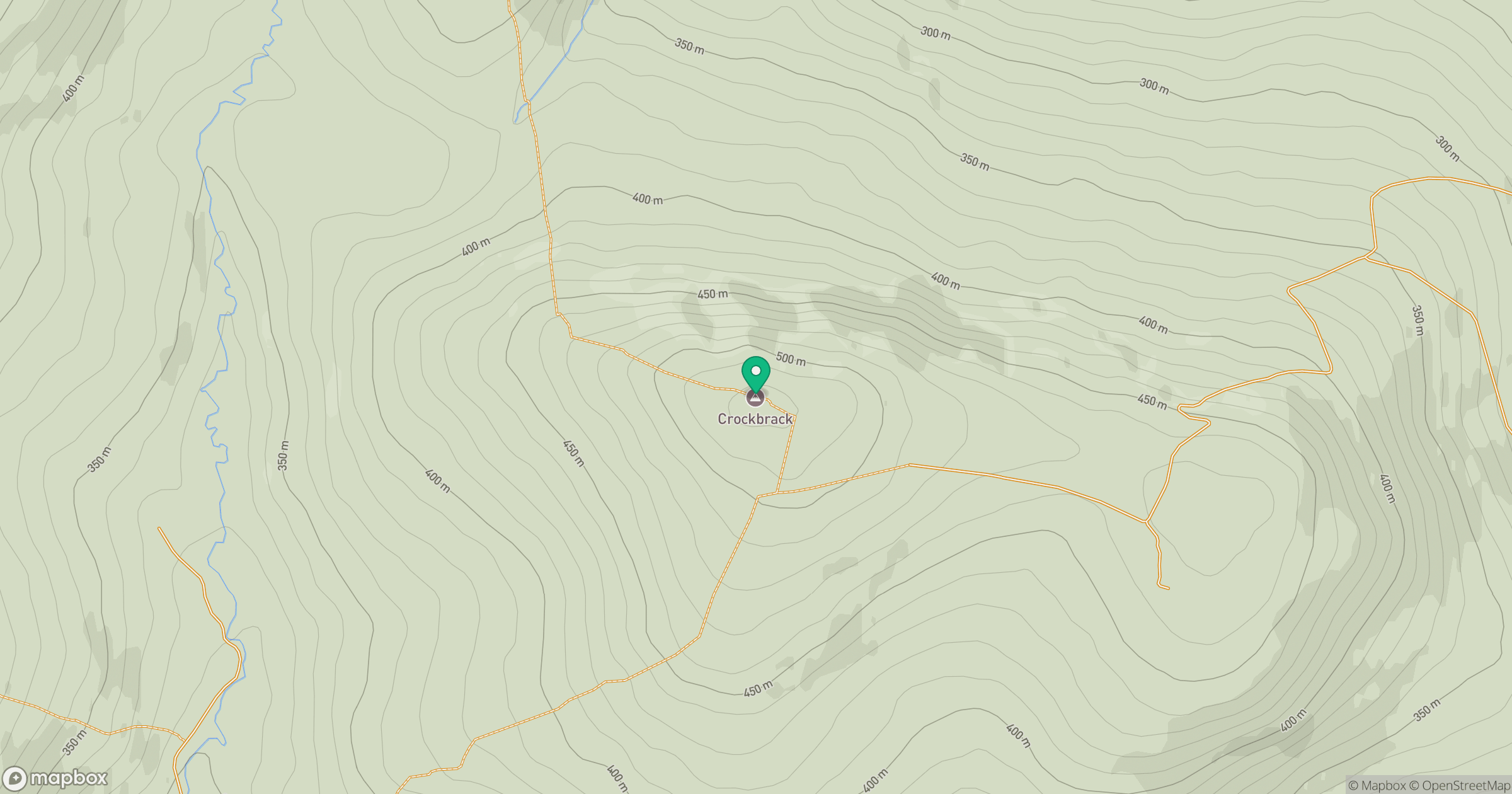
Grid reference: H716957
View on OpenStreetMapOpens a map in a new tab, centred on the hill.
Hills within 30 km
Straight-line distance, not a walking route or confirmation of access.
No comments yet. Be the first.