
Cregganconroe
Good walks are even better shared.
Overview
Cregganconroe
Cregganconroe, standing at a modest elevation of 295 meters within the beautiful Sperrin Mountains of Northern Ireland, may not be the highest peak, but it certainly offers a slice of adventure and stunning views that you won't want to miss.
Geology
This mountain showcases local geological wonders, with its sandstone and mudstone formations telling stories of ancient environments. The sedimentary nature of the rocks adds to the rugged charm, and who knows, you might even discover a fossil or two!
Routes
The Cregganconroe Loop is a widely loved route, making for a perfect afternoon's jaunt. Covering approximately 5.2 km and taking about 2.5 hours, this moderate trek offers both easy walking and the occasional rocky outcrop to keep you on your toes.
Summit Features
On reaching the summit, hikers are greeted by a charming stone cairn that's become a bit of a local landmark. It's a lovely spot for a well-deserved rest and the perfect place to snap some photos.
Terrain
Expect a delightful mix of grassy slopes and rocky areas – just the right recipe for a bit of a scramble without needing to rock-climb!
Views
The panorama from Cregganconroe is simply breathtaking. Not only can you gaze upon the sprawling Sperrin Mountains, but on a clear day, the distant Mourne Mountains might just wave hello.
Best Seasons: Late spring and autumn are peak times for those postcard-worthy views.
Hazards
Like a sneaky fox, the weather can change quite rapidly, so be sure to layer up – bring a waterproof jacket just in case! Additionally, watch your footing on rocky sections to avoid sending yourself tumbling.
Nearby Summits
For the keen peak-baggers, consider checking out nearby summits like Slemish and Binevenagh, which offer their own unique adventures.
Access
You can find parking at a layby near Straw village. Public transport is available, but check local schedules as they can be tricky to pin down. Don’t forget, Draperstown is your nearest haven for food, drinks, and a loo!
Facilities
Currently, facilities are limited in the area. However, if you venture to Draperstown, you will find a selection of cafes and shops ready to refuel you!
History
The name 'Cregganconroe' hints at a royal past with its etymological roots translating to 'Rocky place of the king'. Lush stories of ancient tribes using the mountain as a navigational guide only add to the allure of this charming peak.
Happy hiking! Ensure you pack your sense of adventure!
Explore routes near Cregganconroe
Public walks starting within 80 km of this hill. Nearby does not mean a route reaches the summit; check its map and access before setting out.
Peatlands Park Red Trail: Annagarriff Wood and Derryadd Lough
View route
Banagher Glen and Forest: complete higher-return circuit
View route
Portadown to Knock Bridge: Bann Boulevard and Moneypenny’s Lock
View route
Derry~Londonderry City Walls Circuit
View route
Route planning notes
These notes describe possible approaches, not verified navigable routes or permission to cross land. Check current paths, local access rules and conditions before setting out.
Cregganconroe Loop
A popular circular route starting from the nearby village, offering a scenic ascent and descent with delightful views.
Make a day of it, together
Find someone to share the walk with, or organise a day out along a route you like.
Hill facts and local notes
Classifications
Elevation
300m
984 ft
Prominence
114m
Coordinates
54.6215, -6.9728
H664753
OS Map
13
At the Summit
The summit is adorned with a mysterious, small stone cairn, possibly built by previous wanderers to mark their spot on a day well spent. There’s a fair chance it’s also home to a few cheeky birds.
Terrain & Geology
Cregganconroe features an intriguing mix of sedimentary rock, primarily composed of sandstone and mudstone, characteristic of the region's geological history. This formation gives way to stunning vistas across the lush landscape.
Views & Scenery
From the summit, you can enjoy extensive views of the Sperrin Mountains, the majestic Lough Neagh, and on a clear day, the Mourne Mountains.
History & Heritage
Name Origin
The name 'Cregganconroe' derives from the Irish 'Craighean Con Roí', meaning 'Rocky place of the king' which sounds rather regal, doesn’t it?
Historical Significance
This mountain holds significance in local folklore and was used as a landmark by ancient tribes, indicating that prominence is not just in elevation!
Getting There & Facilities
Check current local access restrictions, parking rules and transport timetables before travelling. These notes do not confirm public access to the summit.
Parking
There’s ample parking available at the small layby near the village of Straw, just a short walk to the trailhead.
Public Transport
Bus services operate to nearby towns, though check the latest schedules as they can be a bit like a game of hide and seek.
Nearby Facilities
Unfortunately, facilities are sparse in the immediate area; however, a short drive to Draperstown will yield a few cafes, shops, and even a toilet if you’re lucky!
Safety Information
Known Hazards
- Beware of sudden weather changes; the weather can shift quicker than you can say 'pack a jacket'. The terrain may be uneven, so watch your step near rocky outcrops.
General Safety Tips
- Check weather conditions before setting out
- Carry appropriate clothing and equipment
- Let someone know your planned route
- Take a map, compass, and GPS device
- Carry emergency supplies: food, water, first aid kit, torch
Hills
Some common questions about the hills answered
Are there group walks up Cregganconroe?
Many walkers use Walkmates to join or organise walks with others. You can check for group walks around Cregganconroe through the maps
Are there other walkers around Cregganconroe?
Activity varies by location and time, but Walkmates lets you see whether others have shared walks or shown interest in this area. Find other people through the walking friends search walking friends for Cregganconroe search or of course create your own walk for Cregganconroe
Can I organise a walk to Cregganconroe?
Yes. If there aren’t any walks listed already, you can create a walk and make it available for others to join.
If you're signed up to Walkmates, you can create a walk to Cregganconroe.
How do I find a walk up this hill?
There are often multiple ways to walk this hill, depending on experience and route preference. Walkmates helps you explore walks and routes that others have shared.
Can I suggest a new route up Cregganconroe?
Yes. You can suggest or create routes to share with others. Walkmates focuses on the social side of walking, so routes are used to help people organise walks and explore areas together, rather than as detailed navigation tools or route libraries.
Other uses really appreciate knowledgeable walkers sharing their routes. Share your favourite route to Cregganconroe here
The is an error or something incorrect about this hill. How do I let you know?
We always strive to keep the information on Walkmates as accurate as possible. If you find an error, please let us know through the contact form and we'll aim to correct it as quickly as possible
Community Discussion
Comments
Location
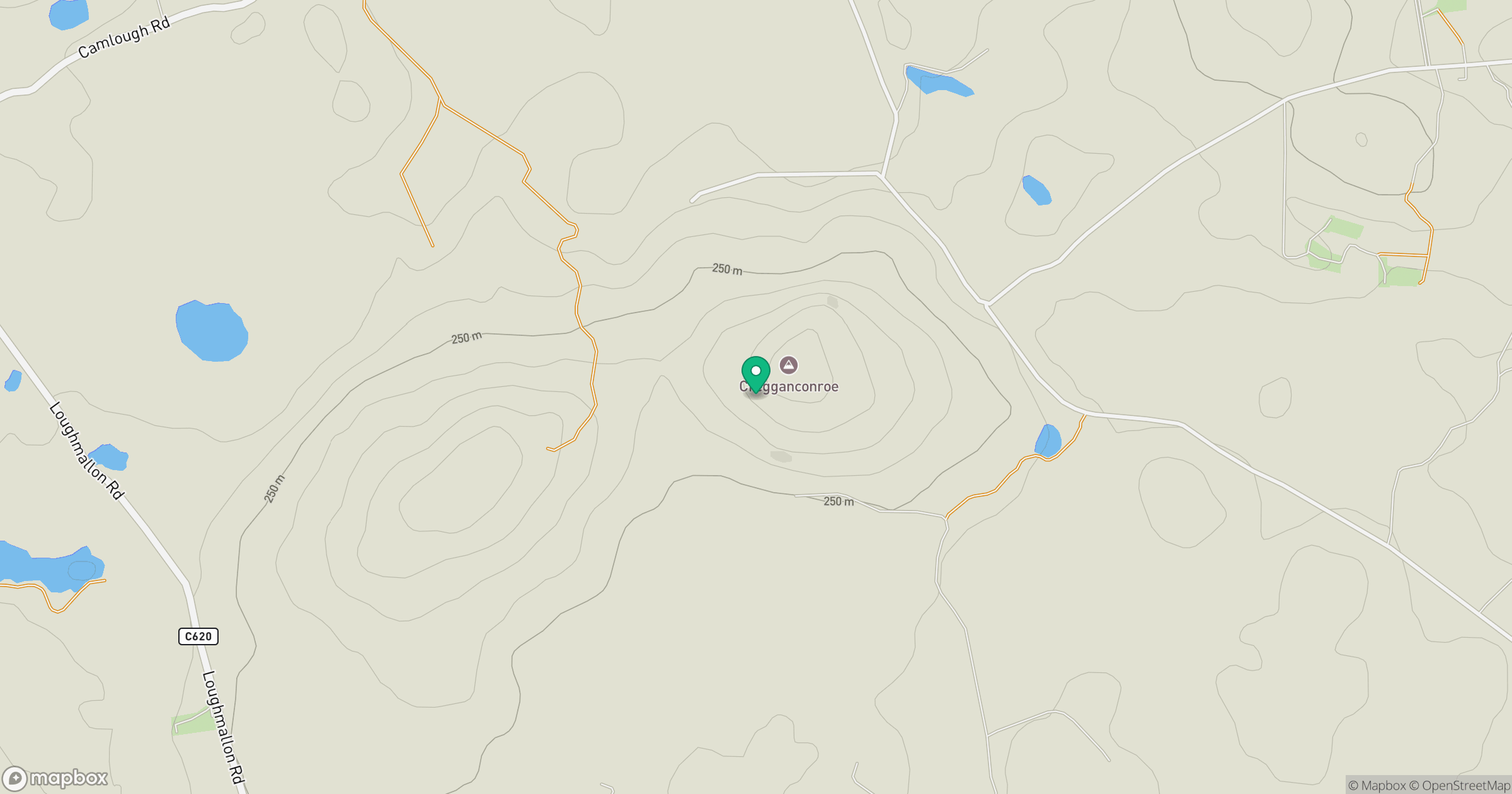
Grid reference: H664753
View on OpenStreetMapOpens a map in a new tab, centred on the hill.
Hills within 30 km
Straight-line distance, not a walking route or confirmation of access.
No comments yet. Be the first.