

Benbradagh
Good walks are even better shared.
Overview
Overview
Benbradagh stands proud at 506 meters, a prominent feature in the stunning Sperrin Mountains of Northern Ireland. Known for its accessible trails and breathtaking vistas, this Marilyn has become a favourite among local hikers. The ascent is manageable, and the well-defined paths lead you through an array of stunning landscapes.
Geology
The hill's geological fabric showcases hardy sandstone and layers of shale, remnants of an ancient marine environment that once thrived here. A geologist's delight, this area can teach us a thing or two about the earth's fantastical history. No need for a lab coat – just a good pair of walking shoes!
Routes
The Benbradagh Hill Walk is the most popular route, spanning approximately 5 km with an elevation gain that is more of a gentle uphill than a relentless slog. Expect to take about 2.5 hours, making it suitable for all but the most casual of strollers.
Summit Features
Upon reaching the summit, hikers are greeted by a modest stone cairn, the ideal backdrop for that all-important summit selfie. Don’t forget to snap a pic before indulging in your well-deserved snack.
Terrain Type
The terrain is primarily grassland dotted with rocky outcrops and patches of lovely heather. Wear those sturdy boots – your feet will thank you!
Views
From the summit, you'll experience a feast for the eyes, with views of the Sperrin Mountains stretching endlessly, and the Vale of Roe sprawling below like a patchwork quilt. Perfect for those who fancy a bit of scenery with their sweat. Late spring to early autumn is the prime time for these vistas, but don’t rule out a crisp winter hike!
Hazards
As with any hike, keep your wits about you. The terrain can become tricky when wet, and the weather has a penchant for being unpredictable. Always check the forecast and consider postponing if it looks grim.
Nearby Summits
After conquering Benbradagh, why not extend your adventure? Nearby, Slieve Gallion at 573 meters and Feeny Hill at 437 meters offer further exploration opportunities, perfect for a day of peak-bagging.
Access
Getting there is a breeze! The nearest parking can be found at Dungiven Forestry Park, which is only a short stroll to the trailhead. Buses do run from Derry/Londonderry, although they might test your patience with their infrequency.
Facilities
Before or after your trek, Dungiven awaits with cafes that can fuel your next adventure.
History
The name Benbradagh holds historical significance, harking back to ancient Gaelic times. The hill isn't just about exercise; it provides a glimpse into the cultural tapestry of the region.
In summary, Benbradagh offers an engaging hiking experience, complete with scenic views, fascinating geology, and a touch of local history. Whether you're a seasoned hiker or just up for a gentle jaunt, the hill welcomes all!
Explore routes near Benbradagh
Public walks starting within 80 km of this hill. Nearby does not mean a route reaches the summit; check its map and access before setting out.
Banagher Glen and Forest: complete higher-return circuit
View route
Derry~Londonderry City Walls Circuit
View route
Portballintrae to Giant's Causeway: railway path and Blue Trail return
View route
Peatlands Park Red Trail: Annagarriff Wood and Derryadd Lough
View route
Route planning notes
These notes describe possible approaches, not verified navigable routes or permission to cross land. Check current paths, local access rules and conditions before setting out.
Benbradagh Hill Walk
A circular route starting from the nearby village of Dungiven, providing a scenic ascent through heaths and forests.
Make a day of it, together
Find someone to share the walk with, or organise a day out along a route you like.
Photo Gallery
View all Photo could not load
C7211 : Bench Mark, Benbradagh
Rossographer
 Photo could not load
C7211 : Benbradagh
Rossographer
 Photo could not load
C7211 : The summit of Benbradagh
David Purchase
 Photo could not load
C7211 : Rocks at the summit of Benbradagh
David Purchase
 Photo could not load
C7211 : Benchmark on Benbradagh
David Purchase
Hill facts and local notes
Classifications
Elevation
465m
1,526 ft
Prominence
171m
Coordinates
54.9441, -6.8741
C722113
OS Map
08
At the Summit
The summit is crowned with a small stone cairn, offering a perfect spot for a photo-op and a well-earned snack break.
Terrain & Geology
Predominantly composed of sandstone and shale, the geology reveals a rich tapestry of sedimentary layers, giving hikers a glimpse into the area's ancient past.
Views & Scenery
Panoramic views of the surrounding Sperrin Mountains, the lush Vale of Roe and, on a clear day, the distant peaks of the Mourne Mountains.
History & Heritage
Name Origin
Benbradagh is derived from the Irish 'Binn Brádaigh', which translates to 'the hill of the Bradach', referring to the area’s historical significance.
Historical Significance
The area holds both geological and archaeological significance, with remnants of ancient settlements nearby.
Getting There & Facilities
Check current local access restrictions, parking rules and transport timetables before travelling. These notes do not confirm public access to the summit.
Parking
There's parking available at the Dungiven Forestry Park, which is just a short walk from the trailhead.
Public Transport
Accessible via local bus services from Derry/Londonderry, though infrequent; check the latest timetables.
Nearby Facilities
While there are no facilities directly on the mountain, Dungiven has several cafes and public toilets to use before or after your hike.
Safety Information
Known Hazards
- Occasional steep sections and changing weather conditions can pose risks, so it's wise to be prepared and keep an eye on the forecast.
General Safety Tips
- Check weather conditions before setting out
- Carry appropriate clothing and equipment
- Let someone know your planned route
- Take a map, compass, and GPS device
- Carry emergency supplies: food, water, first aid kit, torch
Hills
Some common questions about the hills answered
Are there group walks up Benbradagh?
Many walkers use Walkmates to join or organise walks with others. You can check for group walks around Benbradagh through the maps
Are there other walkers around Benbradagh?
Activity varies by location and time, but Walkmates lets you see whether others have shared walks or shown interest in this area. Find other people through the walking friends search walking friends for Benbradagh search or of course create your own walk for Benbradagh
Can I organise a walk to Benbradagh?
Yes. If there aren’t any walks listed already, you can create a walk and make it available for others to join.
If you're signed up to Walkmates, you can create a walk to Benbradagh.
How do I find a walk up this hill?
There are often multiple ways to walk this hill, depending on experience and route preference. Walkmates helps you explore walks and routes that others have shared.
Can I suggest a new route up Benbradagh?
Yes. You can suggest or create routes to share with others. Walkmates focuses on the social side of walking, so routes are used to help people organise walks and explore areas together, rather than as detailed navigation tools or route libraries.
Other uses really appreciate knowledgeable walkers sharing their routes. Share your favourite route to Benbradagh here
The is an error or something incorrect about this hill. How do I let you know?
We always strive to keep the information on Walkmates as accurate as possible. If you find an error, please let us know through the contact form and we'll aim to correct it as quickly as possible
Community Discussion
Comments
Location
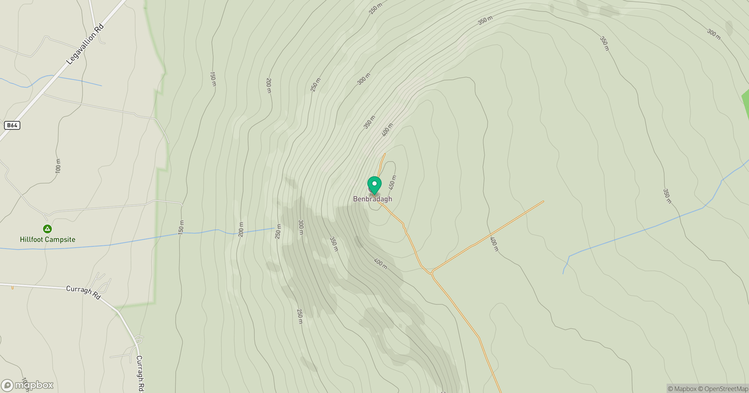
Grid reference: C722113
View on OpenStreetMapOpens a map in a new tab, centred on the hill.
Hills within 30 km
Straight-line distance, not a walking route or confirmation of access.
No comments yet. Be the first.