
Keady Mountain
Good walks are even better shared.
Overview
Keady Mountain
Keady Mountain stands proudly at 532 meters, a Marilyn classification peak in the stunning Southern Uplands of Northern Ireland. This mountain may not be the tallest kid on the block, but it sure has its charm and offers splendid routes for any hiking enthusiast looking to stretch their legs.
Geology
The geological wonders of Keady Mountain mostly comprise ancient granite and gneiss, the kind of rock that has seen things—approximately a billion years' worth of things! The rolling hills and rocky outcrops give it a unique rugged character, making it an excellent spot for both adventure and contemplation. Just don't forget to notice those fabulous mossy patches along the way!
Routes
One popular route is the Keady Mountain Circuit, a delightful circular trek that begins in the village of Keady. This route covers approximately 8 kilometers and takes about 3 hours to complete, depending on your pace and how often you stop to take pictures of the fantastic scenery. Be warned, it might take longer if you’re distracted by the sheep staring at you in disbelief!
Summit Features
The summit is prominently marked by a sizeable stone cairn that serves as a beacon for wandering souls and peak baggers alike. There's also a trig point, perfect for taking that all-important 'we made it!' photograph.
Terrain Type
Expect a mash-up of rocky terrains and grassy slopes—ideal for hiking! But be cautious, some boggy areas lurk about, waiting for unsuspecting feet to make their acquaintance. Consider yourself warned!
Views
Once you reach the top, the views will take your breath away. To the west, Slieve Gullion and the Mourne Mountains command the horizon. For the best views, spring and autumn are the prime seasons when Mother Nature spruces up her attire, so to speak.
Hazards
As always, tread carefully: the rocky paths become quite slippery when wet, and the boggy sections can be a right challenge. Treat them with due respect, or they might just decide to claim your boots!
Access
Getting there is straightforward. A small car park is located at the base of the mountain in Keady village—just be sure to keep an eye out for the local sheep who might decide to share your parking spot! Public transport is also available, with bus services running regularly to Keady from larger towns. The nearest town itself is Keady, where you can stock up on necessities before heading out.
Facilities
Once your hike is over, Keady village has a couple of charming cafes. Enjoy a cup of tea or coffee, and possibly even a slice of cake! Public toilets can typically be found near the community centre, for those urgent needs.
History
The name ‘Keady’ has royal undertones, stemming from the Irish word 'Cáidigh', meaning 'the place of the king.' This mountainous area has housed many historians and cultures over the years, making it not just an adventure destination but a portal into the past as well.
In summary, Keady Mountain offers a delightful day out with fabulous views, interesting terrain, and a touch of history. So, make sure to pack your sense of adventure!
Explore routes near Keady Mountain
Public walks starting within 80 km of this hill. Nearby does not mean a route reaches the summit; check its map and access before setting out.
Banagher Glen and Forest: complete higher-return circuit
View route
Portballintrae to Giant's Causeway: railway path and Blue Trail return
View route
Derry~Londonderry City Walls Circuit
View route
Peatlands Park Red Trail: Annagarriff Wood and Derryadd Lough
View route
Route planning notes
These notes describe possible approaches, not verified navigable routes or permission to cross land. Check current paths, local access rules and conditions before setting out.
Keady Mountain Circuit
A circular route starting from the village of Keady, taking in scenic views of the surrounding countryside.
Make a day of it, together
Find someone to share the walk with, or organise a day out along a route you like.
Hill facts and local notes
Classifications
Elevation
337m
1,106 ft
Prominence
112m
Coordinates
55.0589, -6.8599
C729241
OS Map
08
At the Summit
The summit is marked by a large stone cairn and offers a trig point, making it a popular spot for peak baggers and selfie enthusiasts. Watch out for the occasional sheep wondering what you're doing up there!
Terrain & Geology
Keady Mountain is primarily composed of granite and gneiss, materials formed from intense heat and pressure deep within the Earth's crust. The mountain features characteristic rolling hills and rocky outcrops, giving it an appealing ruggedness.
Views & Scenery
On a clear day, you can see the Slieve Gullion and the Mourne Mountains. The panoramic vistas are truly breathtaking—perfect for admiring whilst taking a deserved rest.
History & Heritage
Name Origin
The name 'Keady' derives from the Irish 'Cáidigh', meaning 'the place of the king'. Typical of Gaelic influence in this region!
Historical Significance
Historically, Keady has been an area of settlement for centuries, with its rich landscape providing resources for early inhabitants.
Getting There & Facilities
Check current local access restrictions, parking rules and transport timetables before travelling. These notes do not confirm public access to the summit.
Parking
There is a small car park at the base of the mountain in Keady village; it's free and should have enough space for a few vehicles. Just watch out for the local sheep.
Public Transport
Regular bus services run to Keady from larger towns like Armagh. Check local timetables for up-to-date information.
Nearby Facilities
The village has a couple of small shops and cafes where you can grab a cuppa and a slice of cake after your adventure. Public toilets are available near the community centre.
Safety Information
Known Hazards
- Rocky paths can be tricky, especially when wet. Watch your footing in the boggy sections, as they have a tendency to claim unwary hikers!
General Safety Tips
- Check weather conditions before setting out
- Carry appropriate clothing and equipment
- Let someone know your planned route
- Take a map, compass, and GPS device
- Carry emergency supplies: food, water, first aid kit, torch
Hills
Some common questions about the hills answered
Are there group walks up Keady Mountain?
Many walkers use Walkmates to join or organise walks with others. You can check for group walks around Keady Mountain through the maps
Are there other walkers around Keady Mountain?
Activity varies by location and time, but Walkmates lets you see whether others have shared walks or shown interest in this area. Find other people through the walking friends search walking friends for Keady Mountain search or of course create your own walk for Keady Mountain
Can I organise a walk to Keady Mountain?
Yes. If there aren’t any walks listed already, you can create a walk and make it available for others to join.
If you're signed up to Walkmates, you can create a walk to Keady Mountain.
How do I find a walk up this hill?
There are often multiple ways to walk this hill, depending on experience and route preference. Walkmates helps you explore walks and routes that others have shared.
Can I suggest a new route up Keady Mountain?
Yes. You can suggest or create routes to share with others. Walkmates focuses on the social side of walking, so routes are used to help people organise walks and explore areas together, rather than as detailed navigation tools or route libraries.
Other uses really appreciate knowledgeable walkers sharing their routes. Share your favourite route to Keady Mountain here
The is an error or something incorrect about this hill. How do I let you know?
We always strive to keep the information on Walkmates as accurate as possible. If you find an error, please let us know through the contact form and we'll aim to correct it as quickly as possible
Community Discussion
Comments
Location
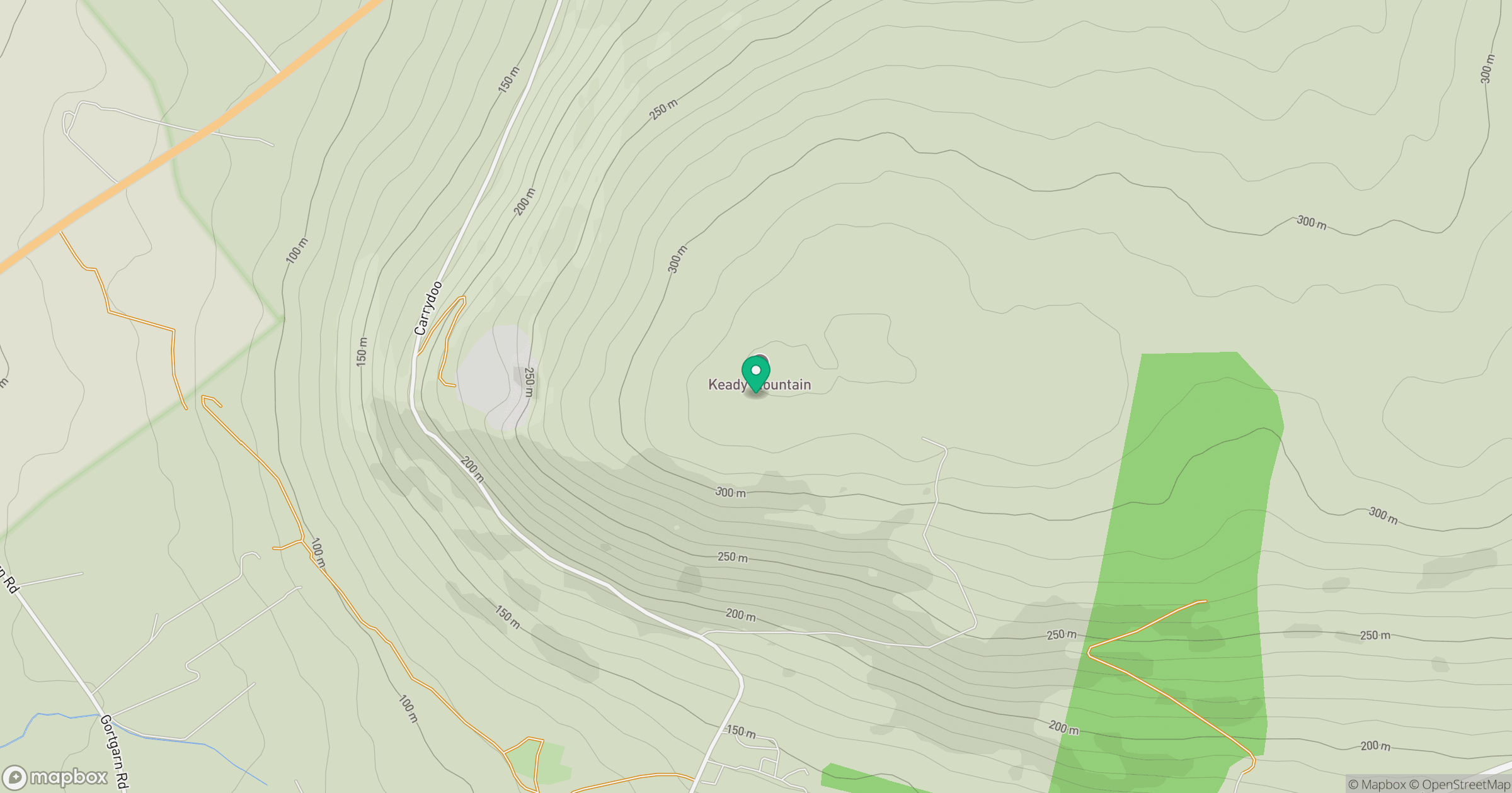
Grid reference: C729241
View on OpenStreetMapOpens a map in a new tab, centred on the hill.
Hills within 30 km
Straight-line distance, not a walking route or confirmation of access.
No comments yet. Be the first.