

Beinn Udlaidh
Good walks are even better shared.
NN2833 : Lochan on Beinn Udlaidh
Iain Russell Photo source
Overview
Beinn Udlaidh: A Scottish Highland Gem
Nestled in the picturesque Scottish Highlands, Beinn Udlaidh is a Marilyn that not only offers a delightful trek but also showcases some of Scotland’s finest natural beauty.
Geology
This mountain is primarily made up of ancient schist along with other metamorphic rocks. It exemplifies a rugged landscape with plenty of boulders and interesting rock formations. It’s a geological wonderland for those with a keen eye (and sturdy boots).
Route Information
The most common route begins at the B844, taking you through heather-clad hills and rocky outcrops. The ascent is moderate, making it accessible yet rewarding. Expect a journey of about 6 km and approximately 2.5 hours to reach the summit – perfect for a brisk weekend adventure!
Summit Features
At the top, you’ll find a humble cairn, reminding you that sometimes the simplest things are the most rewarding. Don’t forget to take a few snaps; your friends will want proof that you actually climbed a mountain!
Views from the Summit
Once you’ve conquered the summit, the panoramic views will take your breath away (if the uphill hasn’t done that already!). Look westward to Loch Awe or east to the majestic Grampians. The best times to soak in these vistas are during the spring or autumn months when both the flora and weather are cooperating nicely.
Hazards
As with many mountainous adventures, Beinn Udlaidh isn’t without its hazards. Quick weather changes can occur, so it’s best to prepare as if it’s a moody teenager. Additionally, rocky paths can be slippery; a little focus on where you place your feet goes a long way. And, of course, keep an eye out for midges – they can be persistent little critters!
Getting There
Parking is available at a small layby along the B844, though arriving early is advisable for prime spots. If you’re relying on public transport, there’s a bus service from Oban to Taynuilt, but do expect a bit of a walk to get to your starting point. Taynuilt itself is a quaint village where you can stock up on supplies before your trek.
Amenities
There are facilities in Taynuilt including cafés and public toilets, perfect for a pre-hike caffeine boost or a post-hike treat. Nothing beats a slice of cake after a challenging climb!
Historical Significance
The name 'Udlaidh' means 'place of the wolves' – a nod to a time when these magnificent creatures prowled the hills. While today's hikers may not encounter any wolves, they’re bound to appreciate the breathtaking scenery and tranquility.
Beinn Udlaidh is a fabulous choice for anyone looking to immerse themselves in the beauty of the Scottish Highlands. Lace up those hiking boots and set forth for a delightful day out!
Explore routes near Beinn Udlaidh
Walks starting near this hill. Open a route to check its map, distance and full itinerary.
Beinn Ime from Succoth
View route
The Cobbler from Succoth Carpark
View route
Killin: Falls of Dochart, Finlarig and Moirlanich Longhouse
View route
Loch Katrine: Brenachoile Point Shore Walk from Trossachs Pier
View route
Route planning notes
These notes describe possible approaches. Check a route's map and access information when planning your walk.
B844 Route to Summit
This standard route starts at the B844, winding its way upwards through heather-covered hills and rocky outcrops, providing both a hearty cardio workout and stunning views.
Make a day of it, together
Find someone to share the walk with, or organise a day out along a route you like.
Photo Gallery
View all Photo could not load
NN2833 : Lochan on Beinn Udlaidh
Iain Russell
 Photo could not load
NN2833 : Towards the top of Beinn Udlaidh
Steven Brown
 Photo could not load
NN2833 : Autumn snowfall on the Bridge of Orchy hills
Alan O'Dowd
 Photo could not load
NN2833 : Quartz dyke on Beinn Udlaidh
Steven Brown
 Photo could not load
NN2833 : Snow showers out west
Alan O'Dowd
 Photo could not load
NN2833 : Cairn on top of Beinn Udlaidh
David Gruar
 Photo could not load
NN2833 : Approaching the summit of Beinn Udlaidh
Alan O'Dowd
 Photo could not load
NN2833 : Summit of Beinn Udlaidh ('dark or gloomy hill')
Alan O'Dowd
 Photo could not load
NN2833 : Cairn and collapsed aerial, Beinn Udlaidh
Alan O'Dowd
 Photo could not load
NN2833 : Summit of Beinn Udlaidh
Iain Russell
Hill facts and local notes
Classifications
Elevation
840m
2,757 ft
Prominence
522m
Coordinates
56.4601, -4.7926
NN280332
OS Map
50
Explorer: 377E
At the Summit
The summit features a small cairn, and if you’re lucky, you might stumble upon a few hardy mountain flowers peeking through the rocky terrain, waving hello.
Terrain & Geology
Beinn Udlaidh is primarily composed of ancient schist and other metamorphic rock, giving it a rugged appearance and a geologically diverse landscape, peppered with striking boulders and occasionally gritty paths that may put a twist in your trek.
Views & Scenery
From the summit, enjoy sweeping views of the surrounding hills and valleys, including Loch Awe to the west and the impressive peaks of the Grampians to the east.
History & Heritage
Name Origin
The name 'Udlaidh' is derived from Gaelic, meaning 'place of the wolves' – though fortunately, there aren’t any left to greet you on your journey.
Historical Significance
Beinn Udlaidh is noted for its natural beauty and is often appreciated by outdoor enthusiasts looking for a less-travelled route in the Highlands.
Getting There & Facilities
Parking
There is a small layby by the B844 where you can park, but arrive early to avoid a game of musical chairs with other hikers.
Public Transport
The closest bus service runs from Oban to Taynuilt, with connections to other locations, but may require a bit of a stroll to begin your hike.
Nearby Facilities
The nearest café can be found in Taynuilt, and there are public toilets available there, so you can stock up on caffeine before your climb.
Safety Information
Known Hazards
- Watch out for sudden weather changes, slippery rocky paths, and, of course, the ever-dreamy midges that can turn a lovely hike into a buzzing ballet.
General Safety Tips
- Check weather conditions before setting out
- Carry appropriate clothing and equipment
- Let someone know your planned route
- Take a map, compass, and GPS device
- Carry emergency supplies: food, water, first aid kit, torch
Hills
Some common questions about the hills answered
Are there group walks up Beinn Udlaidh?
Many walkers use Walkmates to join or organise walks with others. You can check for group walks around Beinn Udlaidh through the maps
Are there other walkers around Beinn Udlaidh?
Activity varies by location and time, but Walkmates lets you see whether others have shared walks or shown interest in this area. Find other people through the walking friends search walking friends for Beinn Udlaidh search or of course create your own walk for Beinn Udlaidh
Can I organise a walk to Beinn Udlaidh?
Yes. If there aren’t any walks listed already, you can create a walk and make it available for others to join.
If you're signed up to Walkmates, you can create a walk to Beinn Udlaidh.
How do I find a walk up this hill?
There are often multiple ways to walk this hill, depending on experience and route preference. Walkmates helps you explore walks and routes that others have shared.
Can I suggest a new route up Beinn Udlaidh?
Yes. You can suggest or create routes to share with others. Walkmates focuses on the social side of walking, so routes are used to help people organise walks and explore areas together, rather than as detailed navigation tools or route libraries.
Other uses really appreciate knowledgeable walkers sharing their routes. Share your favourite route to Beinn Udlaidh here
The is an error or something incorrect about this hill. How do I let you know?
We always strive to keep the information on Walkmates as accurate as possible. If you find an error, please let us know through the contact form and we'll aim to correct it as quickly as possible
Community Discussion
Comments
Location
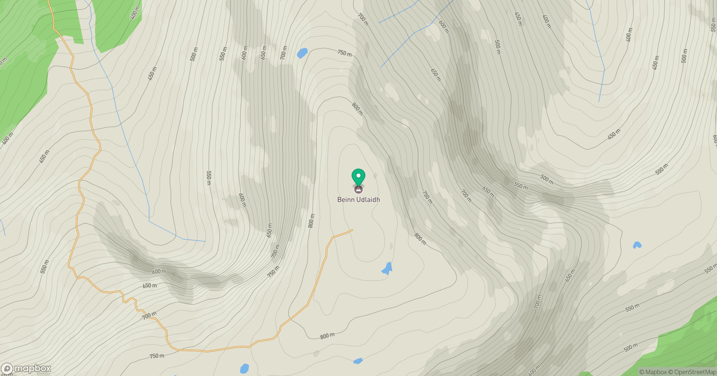
Grid reference: NN280332
View on OpenStreetMapOpens a map in a new tab, centred on the hill.

No comments yet. Be the first.