
Beinn a' Mheadhoin
Good walks are even better shared.
Overview
Beinn a' Mheadhoin
Overview
Beinn a' Mheadhoin stands proudly at 1016 meters, making it a celebrated Munro in the breathtaking Cairngorms. With its granite peaks and varying terrains, it's an adventurous day out for hikers of all levels.
Geology
The mountain's rugged landscape is primarily composed of granite, a testament to the fiery depths of the Earth from which it was formed. This geological history offers abundant opportunities to study the effects of glaciation that carved the stunning valleys we see today.
Routes
Hikers can approach Beinn a' Mheadhoin through several popular routes, each offering unique sights and challenges. The route from Derry Lodge provides a generally moderate hike, perfect for families or less experienced hikers. Alternatively, the Lairig Ghru provides a more challenging trek, ideal for those looking to truly test their mettle!
Summit Features
Once you’ve reached the summit, you’ll be greeted by a sturdy granite cairn that marks the top. It’s a great spot to catch your breath, have a snack, and take in the view — but remember, no summit selfies until the group is together!
Terrain
The terrain can vary greatly, with rocky outcrops and grassy trails offering a bit of variety. Just be wary of the occasional bog; they seem to delight in swallowing unsuspecting hikers’ boots!
Views
As you ascend, keep your eyes peeled for landmarks such as Ben Macdui, the second highest peak in the UK. The best views can be captured in Spring and Autumn, when clear skies are more likely, making those panoramic photographs truly shine.
Hazards
While Beinn a' Mheadhoin is approachable, never underestimate the unpredictable weather of the Highlands. Conditions can change in a flash, so always check the forecast and carry the essentials.
Nearby Summits
For those with more energy to spare, consider summiting nearby giants like Ben Macdui and Braeriach to fully explore the beauty of the Cairngorms.
Access
Starting your journey at Derry Lodge, there’s ample parking available. The nearest town is Aviemore, which provides various amenities to get you ready for your hike.
Facilities
Aviemore is well-equipped with cafes, shops, and restrooms before your adventurous day. Just remember, the journey is part of the experience, so gear up accordingly!
History
The name Beinn a' Mheadhoin evokes its stature and significance in the region. Historically, it has served as a hunting ground and has become an important attraction for climbers and outdoor enthusiasts alike.
So grab your boots and get hiking – Beinn a' Mheadhoin is waiting for you!
Explore routes near Beinn a' Mheadhoin
Walks starting near this hill. Open a route to check its map, distance and full itinerary.
Glen Affric: Coire Loch Woodland Trail
View route
Fort Augustus to Kytra Lock: Caledonian Canal Towpath
View route
Beinn Eighe Lancaster Wreckage at Coire Mhic Fhearchair
View route
Banavie to Glen Loy Aqueduct: Neptune’s Staircase Canal Towpath
View route
Route planning notes
These notes describe possible approaches. Check a route's map and access information when planning your walk.
From Derry Lodge
A popular route starting from Derry Lodge, winding through ancient Caledonian pine forests before ascending the gentler slopes of the mountain.
Via the Lairig Ghru
This route takes you through the dramatic Lairig Ghru pass, offering stunning views and a true sense of wilderness before the summit push.
Make a day of it, together
Find someone to share the walk with, or organise a day out along a route you like.
Hill facts and local notes
Classifications
Elevation
612m
2,008 ft
Prominence
243m
Coordinates
57.2858, -4.9572
NH218255
OS Map
25
Explorer: 415
At the Summit
The summit boasts a prominent cairn, built from local granite that offers a perfect photo opportunity, particularly when the sun is shining.
Terrain & Geology
Composed primarily of granite, Beinn a' Mheadhoin showcases the rugged beauty typical of the Cairngorms, with scoured rock faces hinting at the area's glacial past.
Views & Scenery
On a clear day, hikers can see the expansive stretch of the Cairngorms, including the distant peaks of Ben Macdui and Braeriach.
History & Heritage
Name Origin
The name 'Beinn a' Mheadhoin' translates to 'Mountain of the Middle', likely due to its central location in the Cairngorm range.
Historical Significance
Previously significant for hunting grounds and later for climbers and hikers, it embodies the spirit of the Scottish Highlands.
Getting There & Facilities
Parking
Parking is available at the Derry Lodge car park, which accommodates several vehicles and has direct access to the trails.
Public Transport
Limited public transport is available, with some buses operating from Aviemore. It's advised to check local schedules.
Nearby Facilities
Aviemore has various facilities, including cafes, shops, and toilets. The nearby Derry Lodge has no facilities.
Safety Information
Known Hazards
- Weather can change rapidly in the Highlands, and the presence of boggy ground can lead to slips. Always be prepared!
General Safety Tips
- Check weather conditions before setting out
- Carry appropriate clothing and equipment
- Let someone know your planned route
- Take a map, compass, and GPS device
- Carry emergency supplies: food, water, first aid kit, torch
Hills
Some common questions about the hills answered
Are there group walks up Beinn a' Mheadhoin?
Many walkers use Walkmates to join or organise walks with others. You can check for group walks around Beinn a' Mheadhoin through the maps
Are there other walkers around Beinn a' Mheadhoin?
Activity varies by location and time, but Walkmates lets you see whether others have shared walks or shown interest in this area. Find other people through the walking friends search walking friends for Beinn a' Mheadhoin search or of course create your own walk for Beinn a' Mheadhoin
Can I organise a walk to Beinn a' Mheadhoin?
Yes. If there aren’t any walks listed already, you can create a walk and make it available for others to join.
If you're signed up to Walkmates, you can create a walk to Beinn a' Mheadhoin.
How do I find a walk up this hill?
There are often multiple ways to walk this hill, depending on experience and route preference. Walkmates helps you explore walks and routes that others have shared.
Can I suggest a new route up Beinn a' Mheadhoin?
Yes. You can suggest or create routes to share with others. Walkmates focuses on the social side of walking, so routes are used to help people organise walks and explore areas together, rather than as detailed navigation tools or route libraries.
Other uses really appreciate knowledgeable walkers sharing their routes. Share your favourite route to Beinn a' Mheadhoin here
The is an error or something incorrect about this hill. How do I let you know?
We always strive to keep the information on Walkmates as accurate as possible. If you find an error, please let us know through the contact form and we'll aim to correct it as quickly as possible
Community Discussion
Comments
Location
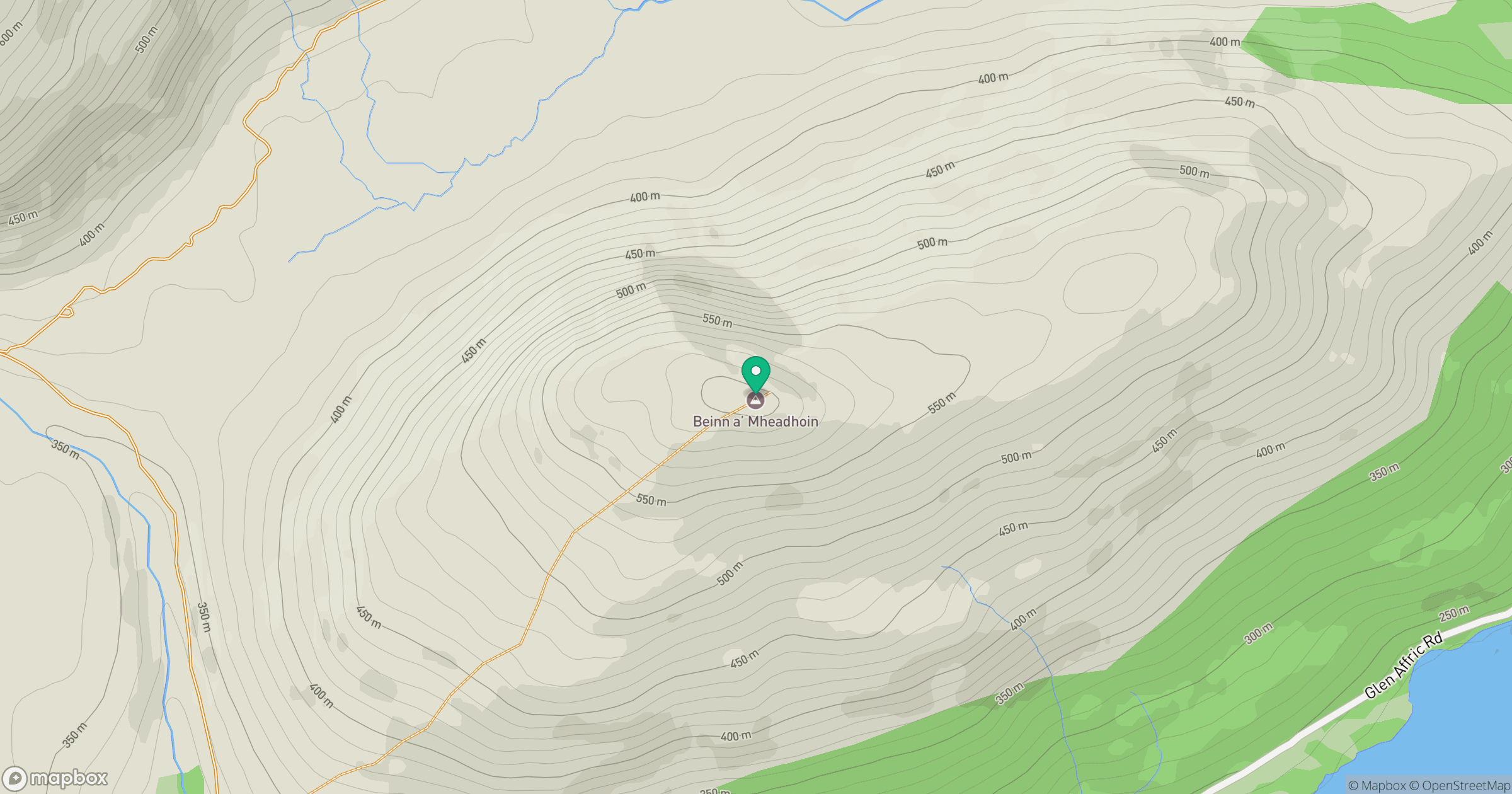
Grid reference: NH218255
View on OpenStreetMapOpens a map in a new tab, centred on the hill.
Nearby Hills
Carn Eighe
1,183m
Mam Sodhail
1,179m
Sgurr a' Choire Ghlais
1,084m
Gleouraich
1,035m
Sgurr Fhuaran
1,069m
No comments yet. Be the first.