
Beinn nan Sparra
Good walks are even better shared.
Overview
Beinn nan Sparra: A Hiker's Delight
Overview
Beinn nan Sparra stands tall at 817 meters in the Scottish Highlands, offering a splendid experience for hikers of all abilities. This Corbett is often overlooked but promises rewarding views and a thrilling adventure.
Geology
The mountain is composed mainly of Moine schists, giving it character. These ancient rocks not only tell a tale of geological time but offer excellent grip (mostly) for those brave enough to explore their rugged slopes. Just remember: if geology interests you, congratulations, you’re in good company!
Routes
East Ridge Route
Starting from a quaint parking spot along the A831, this route spans approximately 9km and can be tackled in about 3.5 hours. The path is moderate in difficulty, weaving through beautiful landscapes, offering aspirational views.
Summit Features
Once you reach the top, you’ll be greeted by a sturdy cairn—perfect for taking a well-deserved selfie. Just don’t forget to pose like you’ve conquered Everest!
Terrain
Expect a combination of grassy slopes and rocky outcrops, along with the occasional bog that will test your boots. It’s a true Highland experience!
Views
The panoramic views are exquisite, with Loch Ness stealing the show to the south, alongside a backdrop of the Glen Affric peaks that will make any photographer's heart race.
Best seasons for these views are in spring and autumn when the skies are typically clearer.
Hazards
Be mindful of the rapidly changing weather, a classic trait of the Highlands, and be aware that some sections may be slippery when wet – it’s not a dance competition up there!
Nearby Summits
Explore further with nearby friendships in peaks such as Carn Ghluasaid and Sgurr na Lapaich, both waiting to be trekked!
Access
Parking is available at a small lot along A831. Public transport is scarce around here – this mountain won’t come to you! A tip: the closest bus is to Drumnadrochit, and you’ll need a taxi after that.
Facilities
Conveniences can be found in Drumnadrochit, including shops, cafes, and restrooms to prep yourself for the hike ahead.
History
The name Beinn nan Sparra stems from 'Hill of the Sparrows,' and let's be honest, if the sparrows had a say in the matter, they’d probably call it 'The Great Birdwatch Hill.' Its historical relevance resonates with ancient clans who once roamed these lands.
With all these elements combined, Beinn nan Sparra awaits – are you ready for the heights?
Explore routes near Beinn nan Sparra
Public walks starting within 80 km of this hill. Nearby does not mean a route reaches the summit; check its map and access before setting out.
Glen Affric: Coire Loch Woodland Trail
View route
Loch Affric full circuit from River Affric
View route
Fort Augustus to Kytra Lock: Caledonian Canal Towpath
View route
Great Glen Way low route: Fort Augustus to Invermoriston Old Bridge
View route
Route planning notes
These notes describe possible approaches, not verified navigable routes or permission to cross land. Check current paths, local access rules and conditions before setting out.
East Ridge Route
A popular ascent that starts from the small parking area by the A831. This route takes you along a scenic path before ascending the east ridge, offering views of surrounding hills.
Make a day of it, together
Find someone to share the walk with, or organise a day out along a route you like.
Hill facts and local notes
Classifications
Elevation
447m
1,467 ft
Prominence
112m
Coordinates
57.2779, -4.8995
NH253245
OS Map
25
Explorer: 415
At the Summit
At the summit, expect a prominent cairn that provides a perfect backdrop for a photo - after all, nobody goes hiking just to post photos of their lunch, right?
Terrain & Geology
Beinn nan Sparra is primarily composed of ancient Moine schists, which are metamorphic rocks that have been shaped by heat and pressure over hundreds of millions of years. The rugged terrain reflects its geological history, which is fascinating to those who love to study the earth's layers.
Views & Scenery
From the summit, on a clear day, you can see the vast expanse of Loch Ness to the south and the rugged beauty of the surrounding peaks, including the mighty Glen Affric area.
History & Heritage
Name Origin
The name 'Beinn nan Sparra' translates to 'Hill of the Sparrows,' likely a nod to the small birds that can be found around the area, tweeting merrily away.
Historical Significance
The mountain holds historical significance as part of the Highland landscape used by ancient clans during territorial disputes.
Getting There & Facilities
Check current local access restrictions, parking rules and transport timetables before travelling. These notes do not confirm public access to the summit.
Parking
There is a small gravel parking area off A831 near the start of the East Ridge route. Parking is limited, so it fills up quickly on weekends.
Public Transport
Public transport options are limited. The closest station is in Inverness, from where you can catch a bus to Drumnadrochit and then a taxi to the parking area.
Nearby Facilities
In Drumnadrochit, you’ll find cafes, shops, and public toilets. Stock up on snacks before your hike!
Safety Information
Known Hazards
- Watch out for changeable weather conditions, especially in the Highlands. Also, sections can be slippery when wet.
General Safety Tips
- Check weather conditions before setting out
- Carry appropriate clothing and equipment
- Let someone know your planned route
- Take a map, compass, and GPS device
- Carry emergency supplies: food, water, first aid kit, torch
Hills
Some common questions about the hills answered
Are there group walks up Beinn nan Sparra?
Many walkers use Walkmates to join or organise walks with others. You can check for group walks around Beinn nan Sparra through the maps
Are there other walkers around Beinn nan Sparra?
Activity varies by location and time, but Walkmates lets you see whether others have shared walks or shown interest in this area. Find other people through the walking friends search walking friends for Beinn nan Sparra search or of course create your own walk for Beinn nan Sparra
Can I organise a walk to Beinn nan Sparra?
Yes. If there aren’t any walks listed already, you can create a walk and make it available for others to join.
If you're signed up to Walkmates, you can create a walk to Beinn nan Sparra.
How do I find a walk up this hill?
There are often multiple ways to walk this hill, depending on experience and route preference. Walkmates helps you explore walks and routes that others have shared.
Can I suggest a new route up Beinn nan Sparra?
Yes. You can suggest or create routes to share with others. Walkmates focuses on the social side of walking, so routes are used to help people organise walks and explore areas together, rather than as detailed navigation tools or route libraries.
Other uses really appreciate knowledgeable walkers sharing their routes. Share your favourite route to Beinn nan Sparra here
The is an error or something incorrect about this hill. How do I let you know?
We always strive to keep the information on Walkmates as accurate as possible. If you find an error, please let us know through the contact form and we'll aim to correct it as quickly as possible
Community Discussion
Comments
Location
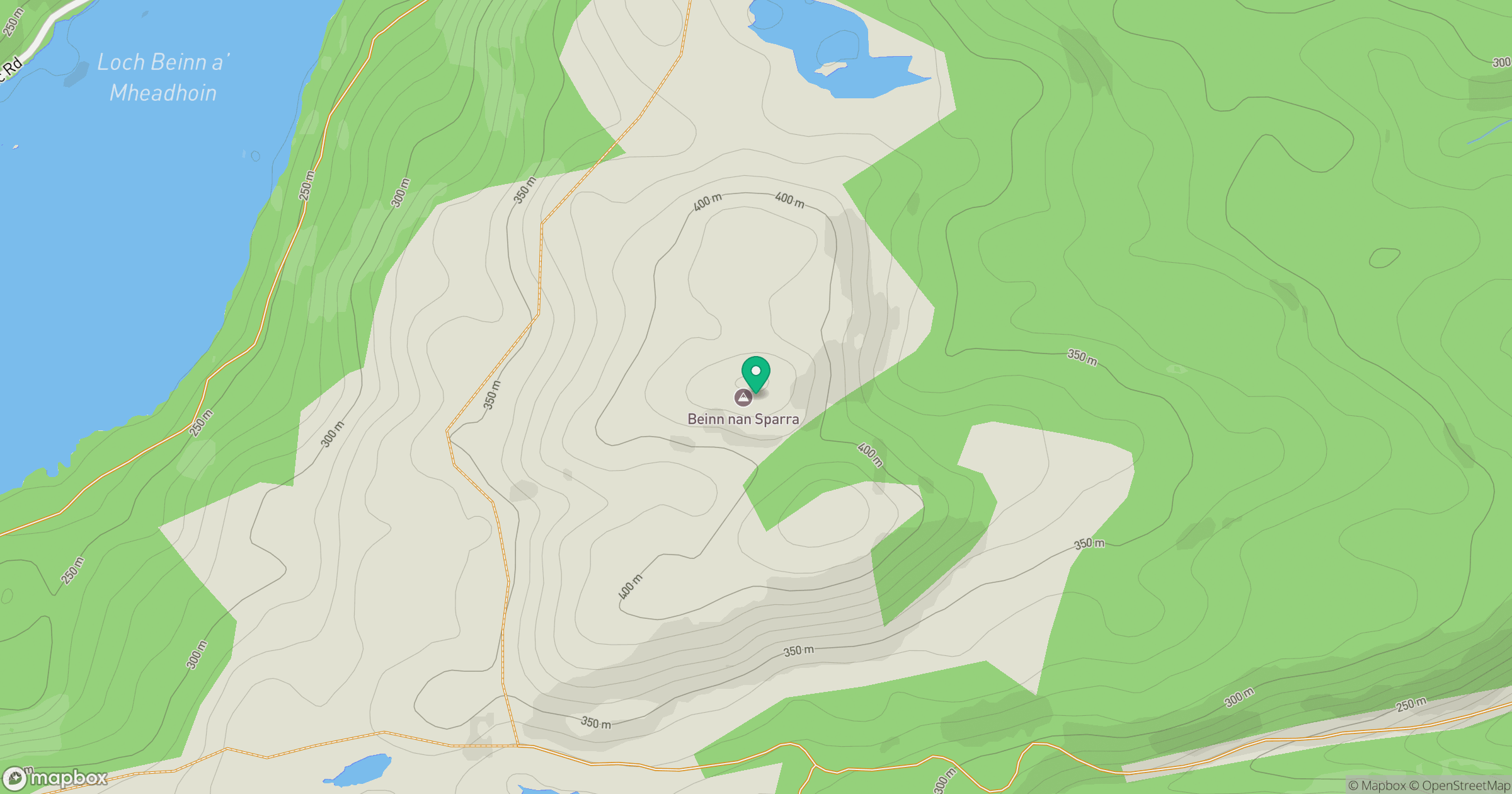
Grid reference: NH253245
View on OpenStreetMapOpens a map in a new tab, centred on the hill.
Hills within 30 km
Straight-line distance, not a walking route or confirmation of access.
Sgurr a' Choire Ghlais
1,084m
Carn Eighe
1,183m
Mam Sodhail
1,179m
Gleouraich
1,035m
Beinn Mheadhoin
541m
No comments yet. Be the first.