

Slievegarran
Good walks are even better shared.
Overview
Slievegarran: A Hiker's Delight
Overview
Nestled in the heart of Southeast Donegal, Slievegarran offers an unforgettable hiking experience for those willing to take up the challenge. With an elevation of 493 meters, it qualifies as a Marilyn, making it a standout feature of the locale.
Geology
Slievegarran's geology is predominantly made up of granite, showcasing some interesting rock formations. As you traverse this mountain, be sure to keep an eye out for the stunning boulders that tell the tales of time.
Routes
There are a couple of fantastic routes to explore:
- Ballyshannon Route: This moderate 8.0 km path takes roughly 3.5 hours and begins in the village of Ballyshannon. The scenery is lush, making for an enjoyable hike.
- Mullaghmore Route: For those seeking a challenge, this 10.5 km route from Mullaghmore Head offers a mix of breathtaking coastal views and a demanding ascent, taking about 4.5 hours.
Summit Features
At the summit, you'll find a quaint cairn, often adorned with stones left by fellow hikers. It's a great spot for a quick snack and to soak in the views.
Terrain Type
The terrain ranges from grassy slopes to rocky paths, with some boggy sections. Make sure to wear suitable footwear to avoid any slips and slides!
Views
The views from Slievegarran are nothing short of spectacular. On a clear day, you can see Donegal Bay and the distant Bluestack Mountains, making it a photographer’s paradise!
Hazards
Hiking Slievegarran requires a degree of caution. Sudden weather changes can occur, making it essential to check the forecast beforehand. Additionally, be cautious of the slippery terrain, especially after rain.
Access
You can find parking at the Ballyshannon Community Centre. For public transport, check bus schedules in advance, as they are not as frequent as one would hope. The nearest town is the charming Ballyshannon, where you can refuel after your hike.
Facilities
Ballyshannon has a variety of facilities, including cafes and pubs, ideal for a post-hike meal or catch-up with hiking buddies.
History
The name of the mountain, derived from 'Sliabh Garbh', literally translates to 'Rugged Mountain', aptly capturing its essence. Additionally, Slievegarran holds cultural significance in local folklore, celebrated in many tales and stories.
In summary, an adventure on Slievegarran is sure to be a memorable one, combining natural beauty, local culture, and a good dose of exercise. Just remember to pack a snack and a sense of humour!
Explore routes near Slievegarran
Public walks starting within 80 km of this hill. Nearby does not mean a route reaches the summit; check its map and access before setting out.
Castlewellan Forest Park: Lake, Arboretum and Mitchell's Lake Circuit
View route
Tollymore Forest Park: Mountain and Drinns Trail
View route
Tollymore Forest Park: River Trail near Newcastle
View route
Newcastle, Co. Down (NI) with Men Walking & Talking
View route
Route planning notes
These notes describe possible approaches, not verified navigable routes or permission to cross land. Check current paths, local access rules and conditions before setting out.
Ballyshannon Route
A scenic path that winds through lush hills and offers stunning views as you ascend. It begins in the village of Ballyshannon.
Mullaghmore Route
Starting from the Mullaghmore Head, this route provides a more challenging ascent, with breathtaking coastal panoramas and the chance to spot the local wildlife.
Make a day of it, together
Find someone to share the walk with, or organise a day out along a route you like.
Photo Gallery
View all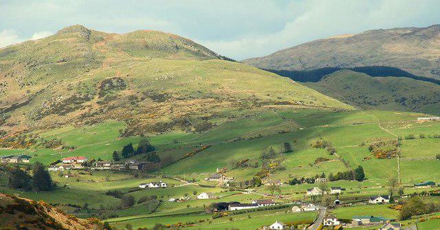 Photo could not load
J3142 : Slievegarran near Castlewellan
Albert Bridge
Hill facts and local notes
Classifications
Elevation
391m
1,283 ft
Prominence
133m
Coordinates
54.3125, -5.9787
J316423
OS Map
20
At the Summit
The summit features a modest cairn, which is often decorated with a few stones left by previous hikers as a sign of their visit. If you have some spare change, leave a little something for good luck!
Terrain & Geology
The mountain is predominantly composed of granite, with some spectacular outcrops that reflect the geological forces that have shaped this region over millennia. You'll find plenty of interesting rock formations and boulders scattered around.
Views & Scenery
From the summit, you can enjoy panoramic views of Donegal Bay, Mount Errigal, and the rugged Atlantic coastline stretching towards Sligo. On a clear day, you might even spot the distant hills of the Bluestack Mountains.
History & Heritage
Name Origin
The name 'Slievegarran' is derived from the Irish 'Sliabh Garbh', meaning 'Rugged Mountain'. Quite fitting considering the terrain this lovely hill presents.
Historical Significance
The mountain is significant in Irish folklore and aesthetics, often associated with the beauty of the lush hills and the captivating views it provides.
Getting There & Facilities
Check current local access restrictions, parking rules and transport timetables before travelling. These notes do not confirm public access to the summit.
Parking
The nearest parking is available at the Ballyshannon Community Centre, providing ample space to leave your vehicle safely while you explore the mountain.
Public Transport
Ballyshannon is serviced by local bus routes from larger towns, but check the schedules as they can be sporadic. Best to have a plan or, better yet, a friend with a car!
Nearby Facilities
Ballyshannon offers a range of facilities, including cafes, pubs, and public toilets. Perfect for a post-hike pint or some well-deserved cake!
Safety Information
Known Hazards
- Watch out for sudden weather changes, as conditions can shift rapidly in this region. Slippery rocks and boggy terrain present additional challenges, so always tread carefully.
General Safety Tips
- Check weather conditions before setting out
- Carry appropriate clothing and equipment
- Let someone know your planned route
- Take a map, compass, and GPS device
- Carry emergency supplies: food, water, first aid kit, torch
Hills
Some common questions about the hills answered
Are there group walks up Slievegarran?
Many walkers use Walkmates to join or organise walks with others. You can check for group walks around Slievegarran through the maps
Are there other walkers around Slievegarran?
Activity varies by location and time, but Walkmates lets you see whether others have shared walks or shown interest in this area. Find other people through the walking friends search walking friends for Slievegarran search or of course create your own walk for Slievegarran
Can I organise a walk to Slievegarran?
Yes. If there aren’t any walks listed already, you can create a walk and make it available for others to join.
If you're signed up to Walkmates, you can create a walk to Slievegarran.
How do I find a walk up this hill?
There are often multiple ways to walk this hill, depending on experience and route preference. Walkmates helps you explore walks and routes that others have shared.
Can I suggest a new route up Slievegarran?
Yes. You can suggest or create routes to share with others. Walkmates focuses on the social side of walking, so routes are used to help people organise walks and explore areas together, rather than as detailed navigation tools or route libraries.
Other uses really appreciate knowledgeable walkers sharing their routes. Share your favourite route to Slievegarran here
The is an error or something incorrect about this hill. How do I let you know?
We always strive to keep the information on Walkmates as accurate as possible. If you find an error, please let us know through the contact form and we'll aim to correct it as quickly as possible
Community Discussion
Comments
Location
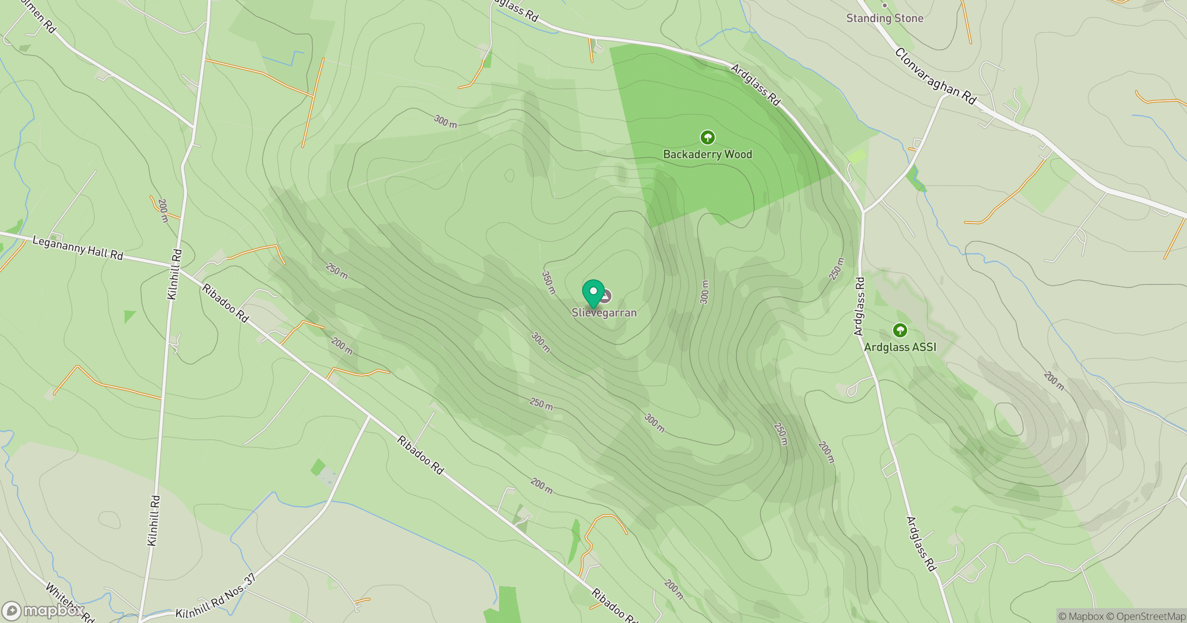
Grid reference: J316423
View on OpenStreetMapOpens a map in a new tab, centred on the hill.
Hills within 30 km
Straight-line distance, not a walking route or confirmation of access.
Slieve Bearnagh
739m
Slieve Commedagh
767m
Slieve Donard
850m
Slievelamagan
702m
Slieve Binnian
746m
No comments yet. Be the first.