

Slieve Gallion NE Top
Good walks are even better shared.
H8189 : Cairn at Slieve Gallion
Kenneth Allen Photo source
Overview
Slieve Gallion NE Top
Nestled in the beautiful landscape of Northern Ireland, Slieve Gallion NE Top is a Marilyn that promises both adventure and breathtaking views. Standing at an elevation of 598 meters, it might not be the tallest mountain around, but it carries its own charm and allure.
Geology
This mountain is primarily composed of basalt, resulting from volcanic activity millions of years ago. The unique geological formations create stunning cliffs and perfect venues for some amateur photography – the Instagram feed will thank you!
Access and Parking
Getting there is a breeze with a car park located conveniently at the trailhead. If you're hopping on public transport, the local bus services do connect to Draperstown, though don't expect them every fifteen minutes. The nearest town, Draperstown, is brimming with character and the locals are known for their warm hospitality!
Routes
One popular route is the Slieve Gallion Circular Walk. This picturesque loop offers a manageable distance of 7.5 km and takes about 3.5 hours, making it suitable for most hikers. Keep your eyes peeled for some delightful wildlife along the way!
Summit Features
At the summit, you'll find a charming cairn alongside a trig point which is an absolute must for a summit photo. Remember, if you didn't take a selfie at the top, did you even hike it?
Terrain
The terrain is a mix of rocky paths and grassy inclines. As you navigate, be warned of the boggy patches that might catch you unaware - so wear those hiking boots!
Views
From the summit, the panoramas are nothing short of majestic. Look eastward for a view of the Mourne Mountains, take a peek at the Sperrins to the north, and on a clear day, Lough Neagh sprawls out like a blue ribbon on the landscape.
Hazards
As beautiful as it is, the mountain can have fickle weather. Fog can roll in, especially during winter, so be sure to dress appropriately and brush up on your navigation skills. Safety first, folks!
Nearby Summits
For the more ambitious, nearby summits like Slieve Gallion at 615 meters and Slievebane a bit lower at 568 meters can add to your hiking repertoire.
Facilities
After your climb, reward yourself with a proper meal at one of the local cafes in Draperstown. Be sure to check out their cakes; they are a treat! Toilets are also conveniently available in the town.
History
The mountain's name, derived from the Irish language, ties it to local folklore. The landscape is dotted with ancient stone circles and burial sites, keeping the spirit of those who walked here long before us alive.
The Slieve Gallion NE Top is calling – lace up those boots and get out there!
Explore routes near Slieve Gallion NE Top
Walks starting near this hill. Open a route to check its map, distance and full itinerary.
Peatlands Park Red Trail: Annagarriff Wood and Derryadd Lough
View route
Portadown to Knock Bridge: Bann Boulevard and Moneypenny’s Lock
View route
Scarva to Poyntzpass: Newry Canal and Lough Shark Return
View route
Portballintrae to Giant's Causeway: railway path and Blue Trail return
View route
Route planning notes
These notes describe possible approaches. Check a route's map and access information when planning your walk.
Slieve Gallion Circular Walk
A scenic loop starting from the nearby village of Draperstown, offering panoramic views and a manageable ascent.
Make a day of it, together
Find someone to share the walk with, or organise a day out along a route you like.
Photo Gallery
View all Photo could not load
H8189 : Cairn at Slieve Gallion
Kenneth Allen
Hill facts and local notes
Classifications
Elevation
494m
1,619 ft
Prominence
47m
Coordinates
54.7480, -6.7368
H813896
OS Map
13
At the Summit
The summit features a prominent cairn and a trig point, providing a perfect spot for that all-important summit selfie. Don't forget to check in on Instagram!
Terrain & Geology
The mountain is primarily composed of basalt, which forms impressive cliffs and provides a unique terrain for geologists and curious hikers alike.
Views & Scenery
On a clear day, you can enjoy views of the Mourne Mountains to the east and the Sperrin Mountains to the north, and even catch a glimpse of Lough Neagh.
History & Heritage
Name Origin
The name 'Slieve Gallion' comes from the Irish 'Sliabh gCailleann', meaning 'mountain of the hag', linking to local folklore.
Historical Significance
The area is steeped in history, with ancient stone circles and burial sites dotting the landscape, reminding us that this land has been walked for millennia.
Getting There & Facilities
Parking
There is a car park at the base near the trailhead, with ample space for vehicles and a convenient walking path leading to the trail.
Public Transport
Draperstown is accessible via local bus services from neighbouring towns, though service frequency may vary.
Nearby Facilities
There are public toilets available in Draperstown and a few cafes serving hearty meals to refuel after your hike, perfect for a 'cuppa' and a slice of cake.
Safety Information
Known Hazards
- Changeable weather conditions can lead to fog, especially during the winter months. Ensure you have appropriate gear and know how to navigate!
General Safety Tips
- Check weather conditions before setting out
- Carry appropriate clothing and equipment
- Let someone know your planned route
- Take a map, compass, and GPS device
- Carry emergency supplies: food, water, first aid kit, torch
Hills
Some common questions about the hills answered
Are there group walks up Slieve Gallion NE Top?
Many walkers use Walkmates to join or organise walks with others. You can check for group walks around Slieve Gallion NE Top through the maps
Are there other walkers around Slieve Gallion NE Top?
Activity varies by location and time, but Walkmates lets you see whether others have shared walks or shown interest in this area. Find other people through the walking friends search walking friends for Slieve Gallion NE Top search or of course create your own walk for Slieve Gallion NE Top
Can I organise a walk to Slieve Gallion NE Top?
Yes. If there aren’t any walks listed already, you can create a walk and make it available for others to join.
If you're signed up to Walkmates, you can create a walk to Slieve Gallion NE Top.
How do I find a walk up this hill?
There are often multiple ways to walk this hill, depending on experience and route preference. Walkmates helps you explore walks and routes that others have shared.
Can I suggest a new route up Slieve Gallion NE Top?
Yes. You can suggest or create routes to share with others. Walkmates focuses on the social side of walking, so routes are used to help people organise walks and explore areas together, rather than as detailed navigation tools or route libraries.
Other uses really appreciate knowledgeable walkers sharing their routes. Share your favourite route to Slieve Gallion NE Top here
The is an error or something incorrect about this hill. How do I let you know?
We always strive to keep the information on Walkmates as accurate as possible. If you find an error, please let us know through the contact form and we'll aim to correct it as quickly as possible
Community Discussion
Comments
Location
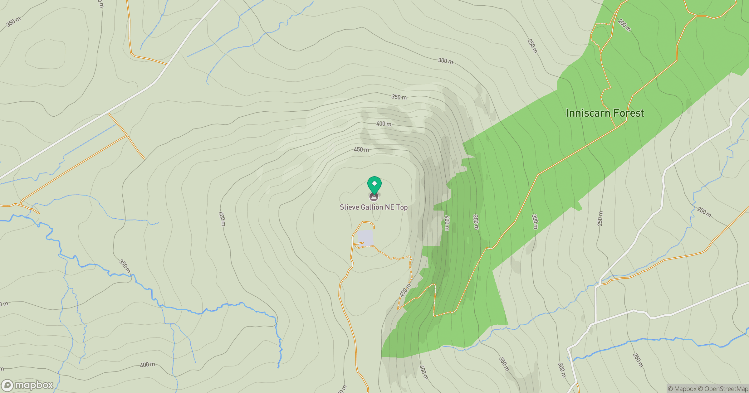
Grid reference: H813896
View on OpenStreetMapOpens a map in a new tab, centred on the hill.
No comments yet. Be the first.