

Slieve Binnian East Top
Good walks are even better shared.
J3223 : View due North to Binnian from the A2 East of Kilkeel
Eric Jones Photo source
Overview
Slieve Binnian East Top: A Hiker's Delight
Nestled in the heart of the Mourne Mountains, Slieve Binnian East Top stands proudly at 703 meters. This lesser-known cousin of its taller sibling, Slieve Binnian, offers spectacular views and a rewarding ascent that beckons hikers from all walks of life.
Geological Wonders
The peaks around Slieve Binnian are primarily composed of ancient granite, which provides a fascinating glimpse into the Earth's geological past. Shaped by powerful glaciers, the rock formation lends a rugged aspect to the mountain's character. Remember, while the views are grand, you can thank millions of years of geological processes for their existence!
Route Information
One of the most favored routes to the summit is the Binnian and Murlough Route. Starting at the Carricklittle car park, this path offers a delightful mix of scenery and challenge, approximately 10.5 kilometers in length. It’s moderate in difficulty, making it suitable for most outdoor enthusiasts—just don’t forget to pack a snack to enjoy at the top!
Summit Features and Views
When you reach the top, you’ll be greeted by a stone cairn—a perfect photo spot to capture your victory at 703 meters. The views from here are simply breathtaking. To the north, you can see the rugged contours of the Mourne range, while to the south, the shimmering expanse of the Irish Sea unfolds in a marvellous panorama. A sight not to be missed in any weather!
A Word of Caution
As picturesque as this mountain is, it’s not all roses. Loose rocks abound, and steep ascents can be challenging, particularly after rain when paths can become slippery. Always stay on your toes, quite literally! Visibility can quickly decrease in poor weather, so plan accordingly.
Nearby Summits
Don't stop at Slieve Binnian East Top—explore its more prominent siblings like Slieve Binnian (747 meters) and Slieve Donard (849 meters), famous for being the highest in the Mourne range. Each summit has its own unique flair and views.
Access and Facilities
The journey begins at the Carricklittle car park. Just be mindful that this spot fills rapidly during the weekends! If you’re relying on public transport, services to the Mournes are sporadic, so check your schedule ahead of time. The nearest town, Newcastle, boasts cafes and essential facilities if you need to refuel after your trek.
A Journey Through History
The name 'Binnian' has a melodic quality, potentially stemming from the Irish 'Binneán,' meaning 'little peak.' This etymology lends a sense of charm, which complements the area's rich tapestry of folklore and history—a testament to its cultural significance within the Mourne Mountains.
Conclusion
A hike up Slieve Binnian East Top is a fantastic day out for adventurers eager to explore the rugged beauty of Northern Ireland. It’s more than just a climb; it's an experience that combines nature, history, and a hearty helping of scenic delight. Just remember to pack your camera—these views will leave you speechless!
Explore routes near Slieve Binnian East Top
Walks starting near this hill. Open a route to check its map, distance and full itinerary.
Silent Valley to Ben Crom Dam: Reservoir Road Walk, County Down
View route
Tollymore Forest Park: River Trail near Newcastle
View route
Newcastle, Co. Down (NI) with Men Walking & Talking
View route
Castlewellan Forest Park: Lake, Arboretum and Mitchell's Lake Circuit
View route
Route planning notes
These notes describe possible approaches. Check a route's map and access information when planning your walk.
Binnian and Murlough Route
A popular route starting from the Carricklittle car park, leading hikers through scenic paths and challenging terrain.
Make a day of it, together
Find someone to share the walk with, or organise a day out along a route you like.
Photo Gallery
View all Photo could not load
J3223 : View due North to Binnian from the A2 East of Kilkeel
Eric Jones
 Photo could not load
J3223 : Quarry working area near the summit of the spur
Eric Jones
 Photo could not load
J3223 : View south across the unnamed south-eastern spur of Slieve Binnian
Eric Jones
 Photo could not load
J3223 : The col between Binnian's summit ridge and its unnamed eastern spur
Eric Jones
 Photo could not load
J3223 : View upslope towards the unnamed south-eastern spur of Slieve Binnian
Eric Jones
 Photo could not load
J3223 : View towards the summit of the unnamed south-eastern spur of Slieve Binnian
Eric Jones
 Photo could not load
J3223 : Unnamed subsidiary summit of Slieve Binnian
Eric Jones
 Photo could not load
J3223 : The unnamed south-eastern spur of Slieve Binnian viewed from the col
Eric Jones
 Photo could not load
J3223 : The south-eastern spur of Slieve Binnian
Eric Jones
Hill facts and local notes
Classifications
Elevation
639m
2,096 ft
Prominence
24m
Coordinates
54.1404, -5.9709
J326231
OS Map
30
At the Summit
The summit is marked by a distinct stone cairn, offering a perfect photo op for summiteers eager to prove they've conquered this peak.
Terrain & Geology
The slopes of Slieve Binnian East Top feature granite, a remnant of ancient volcanic activity, shaped by glacial erosion, providing a rugged yet picturesque landscape.
Views & Scenery
Panoramic views of the Mourne Mountains and the Irish Sea, with the impressive outline of Slieve Donard visible in the distance.
History & Heritage
Name Origin
The name 'Binnian' may derive from the Irish 'Binneán,' meaning 'little peak or hill.'
Historical Significance
This peak is part of the historical and mythical Mourne Mountains, rich in folklore and local legends.
Getting There & Facilities
Parking
Carricklittle car park, located off the B180 road, offers ample space for cars but fills quickly on weekends.
Public Transport
Limited bus services operate from Newcastle to the Mourne area; check local timetables.
Nearby Facilities
The nearest facilities, including cafes and toilets, can be found in Newcastle, making it a handy stop for snacks and supplies.
Safety Information
Known Hazards
- Loose stones and steep ascents; poor weather can reduce visibility significantly.
General Safety Tips
- Check weather conditions before setting out
- Carry appropriate clothing and equipment
- Let someone know your planned route
- Take a map, compass, and GPS device
- Carry emergency supplies: food, water, first aid kit, torch
Hills
Some common questions about the hills answered
Are there group walks up Slieve Binnian East Top?
Many walkers use Walkmates to join or organise walks with others. You can check for group walks around Slieve Binnian East Top through the maps
Are there other walkers around Slieve Binnian East Top?
Activity varies by location and time, but Walkmates lets you see whether others have shared walks or shown interest in this area. Find other people through the walking friends search walking friends for Slieve Binnian East Top search or of course create your own walk for Slieve Binnian East Top
Can I organise a walk to Slieve Binnian East Top?
Yes. If there aren’t any walks listed already, you can create a walk and make it available for others to join.
If you're signed up to Walkmates, you can create a walk to Slieve Binnian East Top.
How do I find a walk up this hill?
There are often multiple ways to walk this hill, depending on experience and route preference. Walkmates helps you explore walks and routes that others have shared.
Can I suggest a new route up Slieve Binnian East Top?
Yes. You can suggest or create routes to share with others. Walkmates focuses on the social side of walking, so routes are used to help people organise walks and explore areas together, rather than as detailed navigation tools or route libraries.
Other uses really appreciate knowledgeable walkers sharing their routes. Share your favourite route to Slieve Binnian East Top here
The is an error or something incorrect about this hill. How do I let you know?
We always strive to keep the information on Walkmates as accurate as possible. If you find an error, please let us know through the contact form and we'll aim to correct it as quickly as possible
Community Discussion
Comments
Location
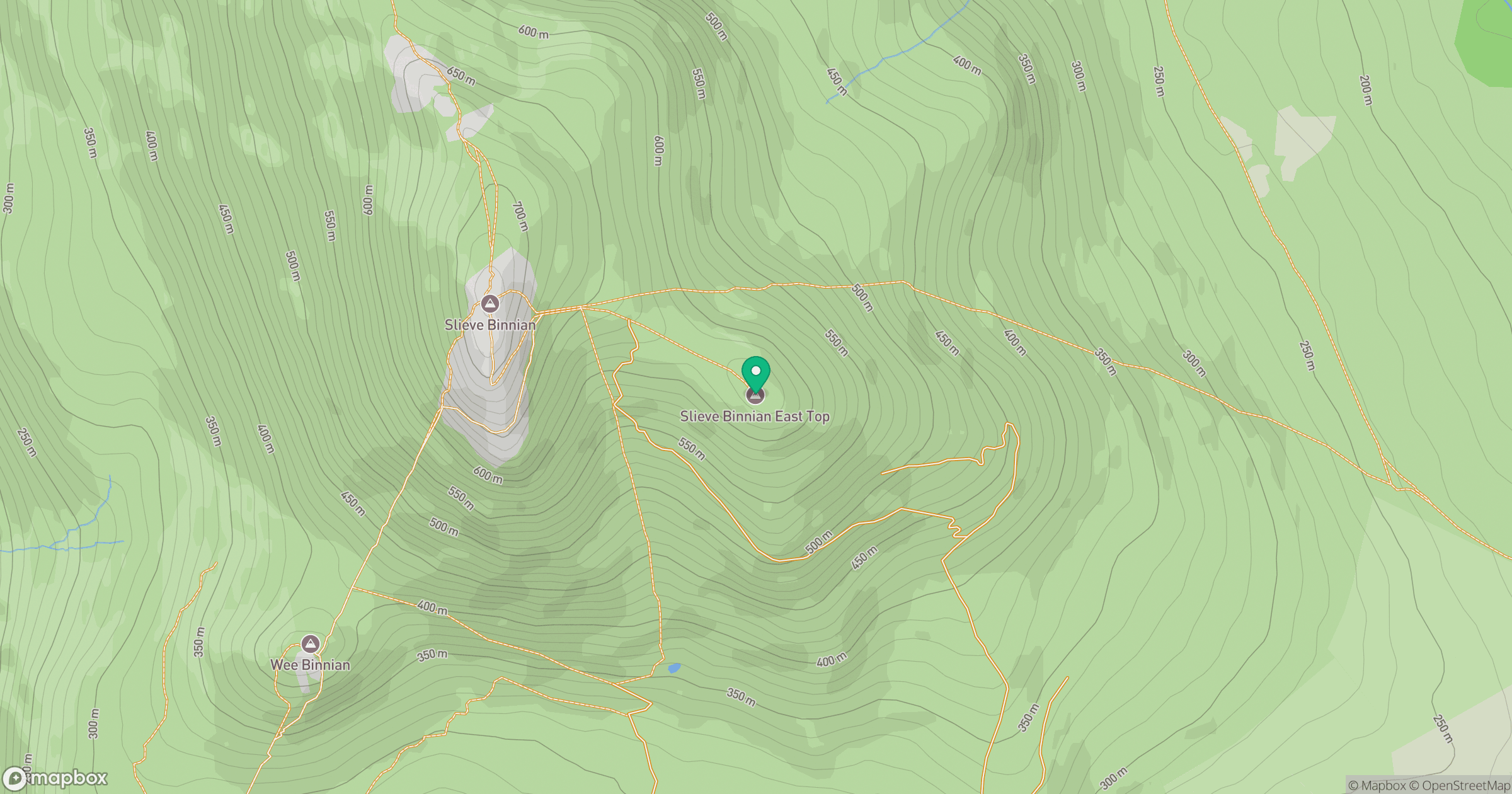
Grid reference: J326231
View on OpenStreetMapOpens a map in a new tab, centred on the hill.
Nearby Hills
Slieve Binnian
746m
Slievelamagan
702m
Slieve Bearnagh
739m
Slieve Commedagh
767m
Slieve Donard
850m
No comments yet. Be the first.