
Slieau Managh
Good walks are even better shared.
Overview
Slieau Managh
Overview
Nestled in the heart of the Isle of Man, Slieau Managh rises gracefully to an elevation of 468 meters. It's a Marilyn, which is a mountain with a prominence of at least 150 meters, making it a fascinating target for both seasoned hikers and casual walkers.
Geology
The mountain's geology showcases the unique volcanic activity that has shaped the Isle of Man over millions of years. With its slate and conglomerate structure, it's not just a feast for the eyes but also a geology buff's delight. So if you’ve ever wanted to impress your friends with rock facts, this is your stage!
Routes
The recommended route, aptly named The Ramble from St. John's, is a moderate trek that covers approximately 7.2 km. It takes about 2.5 hours to reach the summit, during which you'll navigate enchanting green fields, gentle slopes, and some rocky patches. Don't forget to bring along a snack – the summit begs for a picnic!
Summit Features
Reaching the summit, you'll encounter a charming stone cairn. It's the perfect backdrop for a breathtaking photo of your hiking crew — just be cautious not to block the view!
Terrain Type
The terrain is predominantly grassy with some rocky sections and boggy areas that can be a bit tricky, especially after a good rain. Your feet will surely enjoy the variety.
Views
No trek is complete without a good view, and Slieau Managh does not disappoint. From the summit, you can gaze out over the Irish Sea, taking in the surrounding hills and, on clear days, the majestic Welsh mountains on the horizon. For the best views, spring and early autumn are recommended, when the weather is most congenial.
Hazards
While the hike is relatively moderate, a fair warning: the weather can turn quicker than you can say 'slippy'. So be prepared for sudden changes and steer clear of the soggy patches unless you fancy a mud bath!
Nearby Summits
If you're feeling adventurous, consider extending your hike to nearby summits like Slieau Ruy and Snaefell. Each offers its own unique vistas and challenges.
Access
Getting to Slieau Managh is a breeze. The nearest parking is conveniently located in the St. John's village car park. Plus, there are buses that run regularly, so no need to worry if you don’t have your own wheels. St. John's greets you with a quaint charm, setting the perfect tone for your adventure.
Facilities
After your hike, you can reward yourself with a visit to a café in St. John's, where refreshments await. Toilets are also available nearby, to make sure you’re all good before hitting the road.
History
The name Slieau Managh translates from Manx Gaelic to 'mountain of the Manx'. This beautiful hill not only offers physical challenges but also holds cultural significance, being a part of local folklore and history.
Hiking Slieau Managh promises not just a workout, but a delightful experience wrapped in nature’s embrace. Don’t forget to share your adventure with friends — the more stories, the merrier!
Explore routes near Slieau Managh
Walks starting near this hill. Open a route to check its map, distance and full itinerary.
Kilsture Forest Woodpecker Trail
View route
Kirkcudbright Harbour to Barrhill Woods Circuit
View route
Kirroughtree Little Bruntis Lochs and Woodland Trail
View route
Steeple, Scoat Fell and Haycock from Ennerdale
View route
Route planning notes
These notes describe possible approaches. Check a route's map and access information when planning your walk.
The Ramble from St. John's
This route begins in the quaint village of St. John's, leading you through lush green fields and gentle slopes up to the summit.
Make a day of it, together
Find someone to share the walk with, or organise a day out along a route you like.
Hill facts and local notes
Classifications
Elevation
383m
1,257 ft
Prominence
36m
Coordinates
54.2890, -4.4652
SC396909
OS Map
95
Explorer: IoM OL
At the Summit
At the summit, hikers are greeted by a stone cairn and stunning panoramic views, making it a popular spot for a well-deserved rest and a sandwich.
Terrain & Geology
Slieau Managh is predominantly composed of slate and conglomerate, providing a rugged terrain that tells tales of ancient geological activity. The mountain's rock formations are a testament to the island's volcanic history.
Views & Scenery
From the top, you'll see the Irish Sea, the peaks of the surrounding hills, and on a clear day, you might even catch a glimpse of the distant Welsh mountains.
History & Heritage
Name Origin
The name 'Slieau Managh' is derived from the Manx Gaelic, meaning 'mountain of the Manx'.
Historical Significance
Slieau Managh holds cultural significance to the Isle of Man and is often featured in local folklore and hiking guides.
Getting There & Facilities
Parking
Parking is available at the St. John's village car park, which provides ample space for visitors.
Public Transport
Regular bus services connect St. John's with other towns on the island, making it accessible for those without a car.
Nearby Facilities
Nearby facilities include a small café in St. John's, where you can grab a hot drink or snack after your hike. Toilets are available in the village.
Safety Information
Known Hazards
- Be wary of sudden weather changes, as the Isle of Man can be notorious for unexpected conditions. Avoid the boggy sections, especially after rain, as they can be slippery.
General Safety Tips
- Check weather conditions before setting out
- Carry appropriate clothing and equipment
- Let someone know your planned route
- Take a map, compass, and GPS device
- Carry emergency supplies: food, water, first aid kit, torch
Hills
Some common questions about the hills answered
Are there group walks up Slieau Managh?
Many walkers use Walkmates to join or organise walks with others. You can check for group walks around Slieau Managh through the maps
Are there other walkers around Slieau Managh?
Activity varies by location and time, but Walkmates lets you see whether others have shared walks or shown interest in this area. Find other people through the walking friends search walking friends for Slieau Managh search or of course create your own walk for Slieau Managh
Can I organise a walk to Slieau Managh?
Yes. If there aren’t any walks listed already, you can create a walk and make it available for others to join.
If you're signed up to Walkmates, you can create a walk to Slieau Managh.
How do I find a walk up this hill?
There are often multiple ways to walk this hill, depending on experience and route preference. Walkmates helps you explore walks and routes that others have shared.
Can I suggest a new route up Slieau Managh?
Yes. You can suggest or create routes to share with others. Walkmates focuses on the social side of walking, so routes are used to help people organise walks and explore areas together, rather than as detailed navigation tools or route libraries.
Other uses really appreciate knowledgeable walkers sharing their routes. Share your favourite route to Slieau Managh here
The is an error or something incorrect about this hill. How do I let you know?
We always strive to keep the information on Walkmates as accurate as possible. If you find an error, please let us know through the contact form and we'll aim to correct it as quickly as possible
Community Discussion
Comments
Location
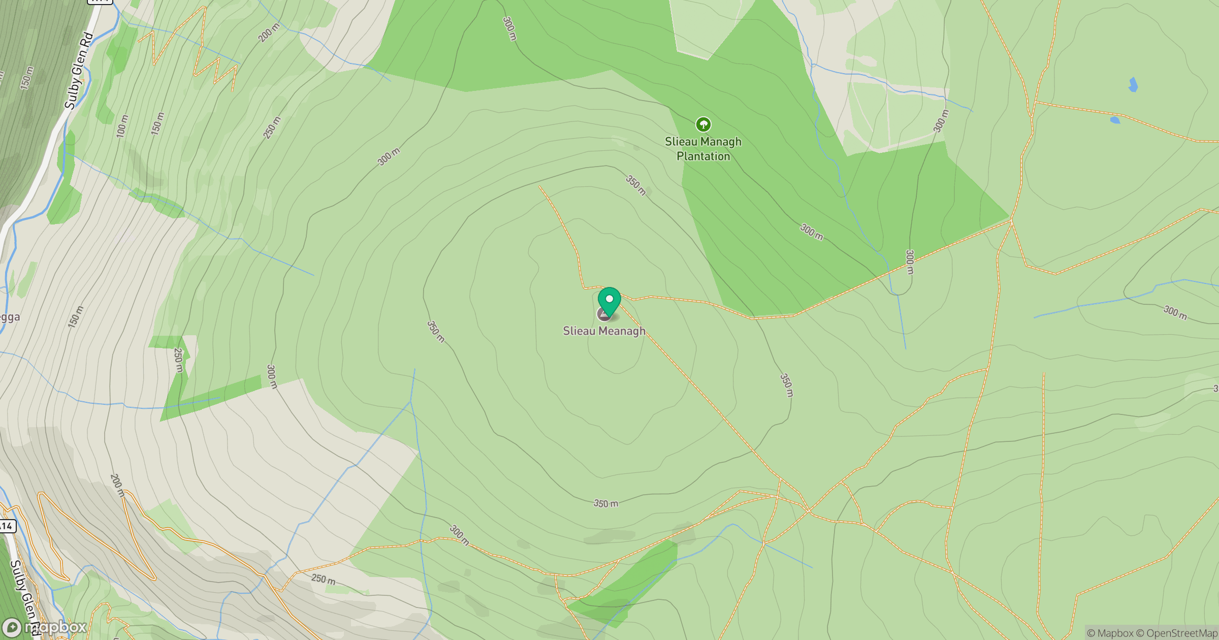
Grid reference: SC396909
View on OpenStreetMapOpens a map in a new tab, centred on the hill.
Nearby Hills
Snaefell
621m
Merrick
843m
Cairnsmore of Carsphairn
797m
Great Orme [Y Gogarth]
207m
Black Combe
600m
No comments yet. Be the first.