
Cronk ny Arrey Laa
Good walks are even better shared.
Overview
Cronk ny Arrey Laa
Nestled in the heart of the beautiful Isle of Man, Cronk ny Arrey Laa stands proud as one of the island's significant hills, boasting an elevation of 404 meters. Whether you are a seasoned hiker or a casual walker, this Marilyn is sure to deliver breathtaking views and invigorating exercise.
Geology
The geology of Cronk ny Arrey Laa is particularly intriguing, composed primarily of sedimentary rocks like limestone and slate. These rocks tell a story that dates back to the Carboniferous period, providing a glimpse into geological formations of bygone eras. Keep an eye out for fascinating rock layers and fossils as you make your ascent.
Routes
One of the most popular routes to the summit is from Druidale. This enjoyable path winds through serene woodlands and up onto open moorland, allowing hikers to immerse themselves in the natural beauty of the Isle of Man. The route measures approximately 8.0 km and typically takes around 3.5 hours to complete. Be prepared to tackle a few moderate slopes along the way!
Summit Features
When you reach the summit, you’ll be greeted by a classic stone cairn and a trig point, making for perfect photo opportunities or a chance to pause and reflect on your achievement. From up here, you can almost proclaim yourself ‘King of the Hill’!
Terrain Type
The terrain on Cronk ny Arrey Laa varies significantly, mixing grassy slopes with rocky outcrops. Just when you think you're on solid ground, you may encounter the occasional boggy area, so sturdy footwear is a must—nobody enjoys a soggy sock!
Views
The views from the summit are simply spectacular. On a clear day, you'll be treated to sweeping sightings of the surrounding hills and the vast Irish Sea beyond. In fact, don’t be surprised if you catch the faint outline of mainland Great Britain, particularly in late spring or early autumn when the skies are especially kind.
Hazards
While the hike provides plenty of reward, one must always be aware of the hazards. Weather on the Isle of Man can change quicker than you can say 'scenic walk', so be prepared for sudden rain or wind. Additionally, watch your footing on rocky or boggy terrain to avoid any unfortunate slips.
Nearby Summits
If you’re feeling adventurous, consider exploring nearby summits such as East Dudley or the South Top of Cronk ny Arrey Laa, which add variety to your hiking experience without the need for a long detour.
Access
Access is straightforward with a small parking area at Druidale conveniently located off the A3. Public transport options are available, but be sure to consult local schedules. The nearby town of Peel not only provides modern amenities but is also a lovely spot to recharge with a warm beverage post-hike.
Facilities
While Cronk ny Arrey Laa lacks facilities on the hill itself, nearby Peel boasts a variety of cafes, toilets, and shops to cater to all your hiking-related needs.
History
The name Cronk ny Arrey Laa translates to 'Hill of the day light', highlighting its prominence on the island. Culturally and historically, this mountain holds a special place in local folklore, and a visit here is not just about hiking—it's about connecting with the spirit of the Isle of Man itself.
So, lace up those boots, grab your walking poles, and let Cronk ny Arrey Laa show you all its charms. Happy hiking!
Explore routes near Cronk ny Arrey Laa
Walks starting near this hill. Open a route to check its map, distance and full itinerary.
Route planning notes
These notes describe possible approaches. Check a route's map and access information when planning your walk.
Druidale to Cronk ny Arrey Laa
A moderate ascent that combines serene woodland and open moorland, eventually leading to panoramic views at the summit.
Make a day of it, together
Find someone to share the walk with, or organise a day out along a route you like.
Hill facts and local notes
Classifications
Elevation
439m
1,440 ft
Prominence
126m
Coordinates
54.1371, -4.7194
SC224746
OS Map
95
Explorer: IoM OL
At the Summit
The summit features a prominent stone cairn and a trig point, perfect for that summit selfie or just pondering life’s big questions.
Terrain & Geology
The mountain is primarily composed of sedimentary rocks, including limestone and slate, which reveal fascinating layers of geological history from the Carboniferous period.
Views & Scenery
From the summit, one can enjoy breathtaking vistas of the surrounding hills, the Irish Sea, and on clear days, the mainland of Great Britain.
History & Heritage
Name Origin
The name 'Cronk ny Arrey Laa' translates roughly as 'Hill of the day light', hinting at its prominence and the beauty of views it offers.
Historical Significance
This mountain is not only a popular hiking destination but also holds cultural significance for the Isle of Man, featuring in local folklore and history.
Getting There & Facilities
Parking
There is a small parking area at Druidale, off the A3. Be sure to park sensibly and avoid blocking any local driveways.
Public Transport
Buses run regularly to the nearby villages, but it's best to check local timetables for up-to-date info.
Nearby Facilities
There are no facilities on the mountain itself, but nearby Peel offers cafes, toilets, and shops for all your pre- and post-hike needs.
Safety Information
Known Hazards
- Be wary of sudden weather changes, as the Isle of Man can be notoriously unpredictable; slippery rocks and boggy areas can also pose risks.
General Safety Tips
- Check weather conditions before setting out
- Carry appropriate clothing and equipment
- Let someone know your planned route
- Take a map, compass, and GPS device
- Carry emergency supplies: food, water, first aid kit, torch
Hills
Some common questions about the hills answered
Are there group walks up Cronk ny Arrey Laa?
Many walkers use Walkmates to join or organise walks with others. You can check for group walks around Cronk ny Arrey Laa through the maps
Are there other walkers around Cronk ny Arrey Laa?
Activity varies by location and time, but Walkmates lets you see whether others have shared walks or shown interest in this area. Find other people through the walking friends search walking friends for Cronk ny Arrey Laa search or of course create your own walk for Cronk ny Arrey Laa
Can I organise a walk to Cronk ny Arrey Laa?
Yes. If there aren’t any walks listed already, you can create a walk and make it available for others to join.
If you're signed up to Walkmates, you can create a walk to Cronk ny Arrey Laa.
How do I find a walk up this hill?
There are often multiple ways to walk this hill, depending on experience and route preference. Walkmates helps you explore walks and routes that others have shared.
Can I suggest a new route up Cronk ny Arrey Laa?
Yes. You can suggest or create routes to share with others. Walkmates focuses on the social side of walking, so routes are used to help people organise walks and explore areas together, rather than as detailed navigation tools or route libraries.
Other uses really appreciate knowledgeable walkers sharing their routes. Share your favourite route to Cronk ny Arrey Laa here
The is an error or something incorrect about this hill. How do I let you know?
We always strive to keep the information on Walkmates as accurate as possible. If you find an error, please let us know through the contact form and we'll aim to correct it as quickly as possible
Community Discussion
Comments
Location
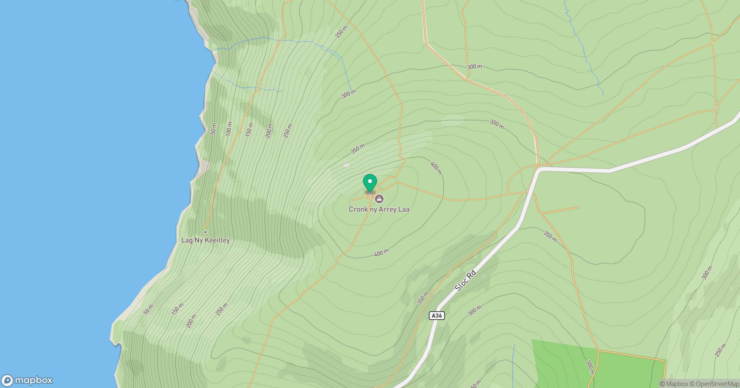
Grid reference: SC224746
View on OpenStreetMapOpens a map in a new tab, centred on the hill.
No comments yet. Be the first.