
Sgurr Thionail
Good walks are even better shared.
Overview
Sgurr Thionail
Nestled in the Scottish Highlands, Sgurr Thionail rises majestically to 927 meters, making it a proud Munro among the likes of its towering companions. The mountain's rugged terrain, composed chiefly of granite, has been shaped over millennia by glacial activity, resulting in stunning vistas that will make any hiker feel like they’ve stumbled into a postcard.
Routes
For the adventurers at heart, the Remote Approach from Inverie is a must-try. Clocking in at approximately 12 km and taking around 6 hours, this challenging route offers a thrilling trek through dense forests before the final ascent. Good things come to those who wait, and the views from the summit are a testament to that.
Summit Features
Upon reaching the top, you’ll be greeted by a cairn that stands as a testament to fellow adventurers who have braved the climb. Sit back, take a breath, and enjoy the panoramic views of the Knoydart Peninsula and the hills beyond. Be sure to have your camera ready, as the beauty is nothing short of captivating!
Terrain
Expect to encounter rocky and grassy patches with some scrambling required. Proper hiking boots are a must unless you fancy a tumble!
Views
On a clear day, Sgurr Thionail offers remarkable views, with the peaks of Skye visible in the distance. The best time to revel in these stunning perspectives is during the early autumn months when the heather is in full bloom and the chill of winter is yet to set in.
Parking and Access
Access to Sgurr Thionail begins from Inverie, a quaint village that can be reached via ferry from Mallaig. Park your vehicle in the limited parking available and prepare for a memorable hike. Remember, the heart of adventure is often found off the beaten path!
Conclusion
So there you have it, hikers! Sgurr Thionail is waiting to be explored. Just remember to bring your sense of adventure and respect for nature, as the Scottish wilderness always rewards those who tread softly.
Last Updated
2023-10-10
Explore routes near Sgurr Thionail
Public walks starting within 80 km of this hill. Nearby does not mean a route reaches the summit; check its map and access before setting out.
Loch Affric full circuit from River Affric
View route
Banavie to Glen Loy Aqueduct: Neptune’s Staircase Canal Towpath
View route
Glen Affric: Coire Loch Woodland Trail
View route
Ben Nevis via Mountain Path
View route
Route planning notes
These notes describe possible approaches, not verified navigable routes or permission to cross land. Check current paths, local access rules and conditions before setting out.
Remote Approach from Inverie
A scenic and remote route starting from the village of Inverie. This path meanders through lush forests before ascending steeply towards the summit, providing hikers with a true wilderness experience.
Make a day of it, together
Find someone to share the walk with, or organise a day out along a route you like.
Hill facts and local notes
Classifications
Elevation
906m
2,971 ft
Prominence
122m
Coordinates
57.1269, -5.3307
NG984089
OS Map
33
Explorer: 414S
At the Summit
The summit features a modest cairn which, similar to a well-intentioned stack of camping gear, stands proud and sturdy against the winds. Beyond the cairn, enjoy panoramic views revealing the rugged splendour of the surrounding hills.
Terrain & Geology
Sgurr Thionail is primarily composed of granite, typical of the region, with notable glacially-carved features. The rugged terrain reflects the powerful geological forces that shaped this breathtaking landscape.
Views & Scenery
From the summit, you can spot the majestic Knoydart Peninsula and even the distant peaks of Skye on a clear day. The blend of lochs and peaks creates a stunning tapestry beneath your feet.
History & Heritage
Name Origin
The name 'Sgurr Thionail' translates to 'Peak of the Hound' in Gaelic, which may owe to the shape of the mountain resembling a guard dog standing proud.
Historical Significance
This mountain is part of the rugged Knoydart range, historically a remote and wild area, often considered one of the last true wildernesses in the UK.
Getting There & Facilities
Check current local access restrictions, parking rules and transport timetables before travelling. These notes do not confirm public access to the summit.
Parking
The nearest parking is available in the village of Inverie, approximately a 5-minute walk from the trailhead. Spaces are limited, so it's best to arrive early to avoid disappointment.
Public Transport
Accessing Inverie typically requires taking a ferry from Mallaig. There are regular ferry services that connect you to this stunning part of the Highlands.
Nearby Facilities
In Inverie, you will find basic facilities including a small shop and a café. Toilets can be hard to come by in the wild expanses, so make sure to plan accordingly!
Safety Information
Known Hazards
- Loose rocks on the ascent, sudden weather changes common in the Highlands, and marked drops from the summit area. Consider carrying a map and compass, just in case technology decides to take a wee break.
General Safety Tips
- Check weather conditions before setting out
- Carry appropriate clothing and equipment
- Let someone know your planned route
- Take a map, compass, and GPS device
- Carry emergency supplies: food, water, first aid kit, torch
Hills
Some common questions about the hills answered
Are there group walks up Sgurr Thionail?
Many walkers use Walkmates to join or organise walks with others. You can check for group walks around Sgurr Thionail through the maps
Are there other walkers around Sgurr Thionail?
Activity varies by location and time, but Walkmates lets you see whether others have shared walks or shown interest in this area. Find other people through the walking friends search walking friends for Sgurr Thionail search or of course create your own walk for Sgurr Thionail
Can I organise a walk to Sgurr Thionail?
Yes. If there aren’t any walks listed already, you can create a walk and make it available for others to join.
If you're signed up to Walkmates, you can create a walk to Sgurr Thionail.
How do I find a walk up this hill?
There are often multiple ways to walk this hill, depending on experience and route preference. Walkmates helps you explore walks and routes that others have shared.
Can I suggest a new route up Sgurr Thionail?
Yes. You can suggest or create routes to share with others. Walkmates focuses on the social side of walking, so routes are used to help people organise walks and explore areas together, rather than as detailed navigation tools or route libraries.
Other uses really appreciate knowledgeable walkers sharing their routes. Share your favourite route to Sgurr Thionail here
The is an error or something incorrect about this hill. How do I let you know?
We always strive to keep the information on Walkmates as accurate as possible. If you find an error, please let us know through the contact form and we'll aim to correct it as quickly as possible
Community Discussion
Comments
Location
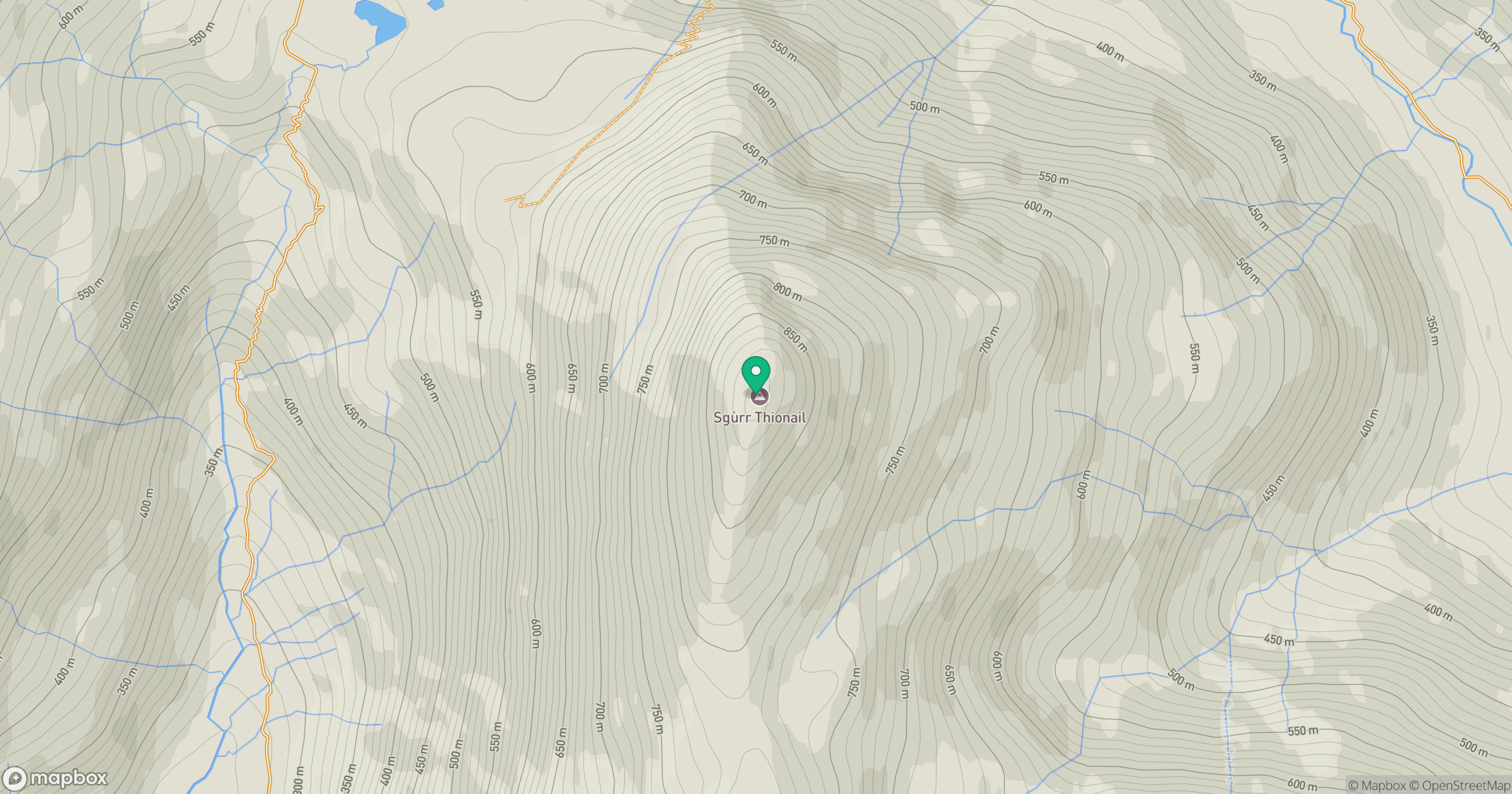
Grid reference: NG984089
View on OpenStreetMapOpens a map in a new tab, centred on the hill.
Hills within 30 km
Straight-line distance, not a walking route or confirmation of access.
Sgurr a' Mhaoraich
1,027m
Sgurr Fhuaran
1,069m
Gleouraich
1,035m
An Caisteal
622m
Beinn Sgritheall
974m
No comments yet. Be the first.