

Sgurr a' Mhaoraich
Good walks are even better shared.
NG9806 : 1010m on Sgùrr a' Mhaoraich
Richard Law Photo source
Overview
Sgurr a' Mhaoraich: A Highland Adventure
Overview
Sgurr a' Mhaoraich is a majestic Munro reaching an elevation of 1011 meters, located in the scenic Scottish Highlands. It offers outdoor enthusiasts an exhilarating experience amid breathtaking landscapes.
Geology
The mountain is made up predominantly of schists and gneisses, which are ancient metamorphic rocks. You might even stumble across some granite, which adds a unique touch to the intricate geological variations around. The ruggedness is a reminder of the glacier's mighty sculpting grace!
Routes
The primary route to the summit is the Allt a' Mhaoraich Route. This moderately challenging path is approximately 12 kilometers long and typically takes about 5 hours to complete. The trail meanders alongside the Allt a' Mhaoraich river, with stunning sights at every turn.
Terrain
Expect a diverse terrain comprising rocky paths and grassy slopes. Be prepared, however, for boggy sections, particularly after rain. A pair of sturdy hiking boots will be your best allies!
Summit Features
As you reach the summit, you'll be greeted by a prominent cairn, a popular gathering spot for those looking to enjoy the panoramic views and perhaps contemplate life’s great mysteries, like why the last biscuit is always the bottom one!
Views
From the summit, the visual feast includes stunning views of surrounding peaks and the shimmering expanse of Loch Nevis. On exceptionally clear days, the Isle of Skye makes a spectacular appearance. The best times to enjoy these vistas are late spring and summer when the heather blooms and the weather graces you with its best.
Hazards
Mountains can be unpredictable! Keep an eye on the skies as sudden weather changes can occur, especially in the fall. Trails can become slippery, so vigilance is key.
Nearby Summits
Sgurr a' Mhaoraich is neighboured by other peaks like Bidein a' Ghlas Thuill (992 meters) and Sgurr na Ciche (1037 meters), both of which are worth exploring if you have a bit of extra energy post-climb.
Access
Nearest Parking
The best parking spot is at the Kinloch Hourn car park, roughly 5 km from the trailhead. Arrive early to secure a spot because this hidden gem sees fair foot traffic!
Public Transport
Be mindful that public transport options are quite limited. The nearest bus service passes through Arnisdale, so plan accordingly.
Nearest Town
The quaint village of Arnisdale is your best bet for amenities post-hike, providing a lovely Highland atmosphere.
Facilities
Facilities are limited in Arnisdale, but you may find a café offering homemade cakes—an excellent treat for your well-deserved post-hike snack! Public toilets are available at the car park.
History
Name Meaning
The name Sgurr a' Mhaoraich translates to 'Peak of the Moors', aptly describing its wild and isolated beauty.
Significance
Historically, this mountain is significant to local communities, serving as a playground for outdoor adventurers and a symbol of Highland culture.
So, lace up those hiking boots and get ready for an adventure that is bound to leave you breathless (in a good way, of course)!
Explore routes near Sgurr a' Mhaoraich
Walks starting near this hill. Open a route to check its map, distance and full itinerary.
Loch Affric full circuit from River Affric
View route
Banavie to Glen Loy Aqueduct: Neptune’s Staircase Canal Towpath
View route
Ben Nevis via Mountain Path
View route
Glen Affric: Coire Loch Woodland Trail
View route
Route planning notes
These notes describe possible approaches. Check a route's map and access information when planning your walk.
Traditional Western Approach from Loch Quoich
This is the most popular route to ascend Sgurr a' Mhaoraich, starting from the parking area near the bridge over Loch Quoich. The route begins by following a stalkers' path that zigzags up the hillside before reaching the ridge. From here, the path becomes steeper and rougher, leading to the summit with stunning views over Knoydart and the surrounding areas.
Circular Route via Am Bathaich
This circular route offers a scenic variation by including the subsidiary top, Am Bathaich. Starting from the same parking area near Loch Quoich, the ascent initially follows the western approach but branches off to include Am Bathaich before continuing along the ridge to the summit. The descent retraces the stalkers' path back to the start.
Eastern Approach via Glen Quoich
This less-traveled route begins further east, from Glen Quoich. It involves a steep ascent through rough terrain to gain the ridge, which is then followed westward to the summit. This route is more remote and provides a quieter experience, with excellent views of the surrounding wilderness.
Extended Ridge Walk Including Gleouraich
For a full day's outing, this route combines the ascent of Sgurr a' Mhaoraich with Gleouraich, another Munro. Starting along the western approach, the route ascends Sgurr a' Mhaoraich first before continuing along the ridge to Gleouraich. The descent follows a stalkers' path back to the road, requiring a short road walk to return to the start.
Winter Ascent from Loch Quoich
This is a winter variation of the western approach, suitable for experienced mountaineers. The route follows the same path as the traditional ascent but requires additional caution, ice axe, and crampons due to snow and ice. The summit views in winter are particularly rewarding on clear days.
Make a day of it, together
Find someone to share the walk with, or organise a day out along a route you like.
Photo Gallery
View all Photo could not load
NG9806 : 1010m on Sgùrr a' Mhaoraich
Richard Law
 Photo could not load
NG9806 : Summit Cairn, Sgurr a' Mhaoraich
Chris Eilbeck
 Photo could not load
NG9806 : The Summit of Sgurr a’ Mhaoraich
Iain Lees
 Photo could not load
NG9806 : View over the Kinlochhourn Forest
Nigel Brown
 Photo could not load
NG9806 : Summit ridge, Sgurr a' Mhaoraich
Chris Eilbeck
 Photo could not load
NG9806 : On the Summit of Sgurr a’ Mhaoraich
Iain Lees
 Photo could not load
NG9806 : Sgurr a' Mhaoraich from Am Bathaich
Michael Earnshaw
 Photo could not load
NG9806 : Summit cairn on Sgùrr a' Mhaoraich
Russel Wills
 Photo could not load
NG9806 : Sgurr a' Mhaoraich
Leslie Barrie

NG9806 : Summit cairn - Sgùrr a' Mhaoraich
Richard Law
Hill facts and local notes
Classifications
Elevation
1,027m
3,368 ft
Prominence
708m
Coordinates
57.1057, -5.3304
NG983065
OS Map
33
Explorer: 414S
At the Summit
A prominent cairn marks the summit, providing a perfect spot for your next Instagram post claiming you conquered a Munro!
Terrain & Geology
Primarily composed of schists and gneisses, with some granite intrusions. The rocky outcrops offer a stunning geological tapestry that tells the story of glacial activity in the region.
Views & Scenery
The remarkable views of the surrounding peaks and the shimmering waters of Loch Nevis are simply breathtaking. You may even spot the Isle of Skye on a clear day.
History & Heritage
Name Origin
The name translates to 'Peak of the Moors', reflecting the rugged, remote nature of the landscape.
Historical Significance
Sgurr a' Mhaoraich holds cultural importance among local communities and is part of many outdoor adventures in the Scottish Highlands.
Getting There & Facilities
Parking
Parking available at the Kinloch Hourn car park, approximately 5 km from the start of the trail. Arrive early as it fills up quickly.
Public Transport
Limited public transport options; the nearest bus service runs through the village of Arnisdale. Plan your trip ahead.
Nearby Facilities
Limited facilities in Arnisdale, though there may be a local café offering homemade cakes (a worthy reward after your climb). Public toilets are available at the parking area.
Safety Information
Known Hazards
- Beware of sudden weather changes, especially in autumn. The trails can be slippery, and visibility can drop quickly.
General Safety Tips
- Check weather conditions before setting out
- Carry appropriate clothing and equipment
- Let someone know your planned route
- Take a map, compass, and GPS device
- Carry emergency supplies: food, water, first aid kit, torch
Hills
Some common questions about the hills answered
Are there group walks up Sgurr a' Mhaoraich?
Many walkers use Walkmates to join or organise walks with others. You can check for group walks around Sgurr a' Mhaoraich through the maps
Are there other walkers around Sgurr a' Mhaoraich?
Activity varies by location and time, but Walkmates lets you see whether others have shared walks or shown interest in this area. Find other people through the walking friends search walking friends for Sgurr a' Mhaoraich search or of course create your own walk for Sgurr a' Mhaoraich
Can I organise a walk to Sgurr a' Mhaoraich?
Yes. If there aren’t any walks listed already, you can create a walk and make it available for others to join.
If you're signed up to Walkmates, you can create a walk to Sgurr a' Mhaoraich.
How do I find a walk up this hill?
There are often multiple ways to walk this hill, depending on experience and route preference. Walkmates helps you explore walks and routes that others have shared.
Can I suggest a new route up Sgurr a' Mhaoraich?
Yes. You can suggest or create routes to share with others. Walkmates focuses on the social side of walking, so routes are used to help people organise walks and explore areas together, rather than as detailed navigation tools or route libraries.
Other uses really appreciate knowledgeable walkers sharing their routes. Share your favourite route to Sgurr a' Mhaoraich here
The is an error or something incorrect about this hill. How do I let you know?
We always strive to keep the information on Walkmates as accurate as possible. If you find an error, please let us know through the contact form and we'll aim to correct it as quickly as possible
Community Discussion
Comments
Location
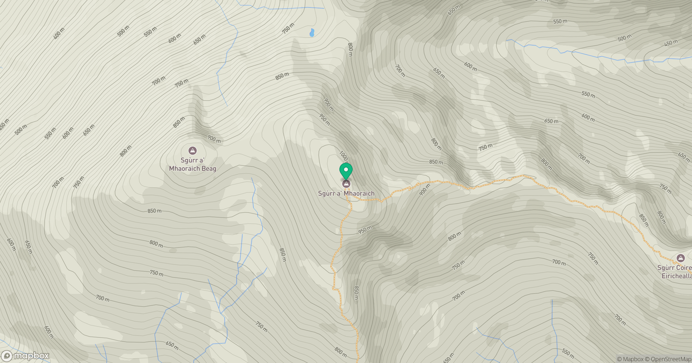
Grid reference: NG983065
View on OpenStreetMapOpens a map in a new tab, centred on the hill.
No comments yet. Be the first.