

Ratho Hill
Good walks are even better shared.
NT1271 : Waterlogged Walk
Anne Burgess Photo source
Overview
Ratho Hill: A Hidden Gem in Central Scotland
Ratho Hill may not be the tallest mountain in Scotland, but what it lacks in elevation, it makes up for in charm and accessibility. Nestled just a stone's throw from Edinburgh, this little Hewitt is perfect for those looking for a quick escape into nature without the need for extensive preparation.
Geology
Ratho Hill is primarily composed of sedimentary rock, such as sandstone and mudstone. The diverse layers exposed in the hill’s crags tell stories of ancient environments and are perfect for aspiring geologists to marvel at. If you stick around long enough, you might just start to see the world through a sedimentary lens!
Routes
The Ratho Hill Circular Walk is the most popular route, offering an easy 4.5 km trek that takes approximately 1.5 hours. Starting from the charming village of Ratho, this walk circles around the hill before ascending to the summit. Along the way, you’ll be treated to delightful views and maybe spot a local sheep or two—just don’t ask them for directions.
Summit Features
On reaching the summit, you’ll find a modest grassy knoll and a small stone cairn standing sentinel over the landscape. It’s the perfect spot for a quick snack or to snap a photo that your social media followers will envy.
Terrain Type
The terrain is mostly grassy but does feature a few rocky sections that add a touch of adventure to your walk. It’s a ‘take it easy’ kind of hike, but those rocks remind you to keep your eyes peeled.
Views
From the top, the views are simply breathtaking. On clear days, the Pentland Hills loom majestically to the south, while to the east, the bustling Edinburgh skyline unfolds, with Arthur's Seat drawing your eye. Spring and Autumn offer the best visibility, so time your hike for those seasons to get the most out of your visit.
Hazards
No hiking experience is without its hazards! In wet conditions, paths can become rather slippery, so tread carefully. And of course, keep your wits about you; you never know when a sheep may decide to cross your path!
Nearby Summits
If you're keen for more adventure, consider a visit to nearby summits such as East Craigs (153m) and Harperrig Hill (311m). They offer additional opportunities for exploration and a lovely day out.
Access
Accessing Ratho Hill is a breeze. The nearest parking is located in the village, just a stone’s throw from the trailhead, and public transport from Edinburgh takes you directly to Ratho. The quaint village has everything you need, including a café for those post-hike refreshments.
Facilities
Ratho has a lovely café where you can enjoy a cuppa and a slice of cake—because what’s a hike without a reward? Plus, there are public toilets available near the parking area to ensure you’re well-equipped for your journey.
History
The name 'Ratho' is thought to come from the Old Norse 'Hraðr', a nod to its historical roots involving ancient fortifications and settlements. This hill isn’t just another pile of rocks; it tells its own story!
In summary, Ratho Hill may not be the highest peak, but it is a delightful destination for anyone looking to enjoy nature without breaking a sweat. Whether you're keen on a peaceful stroll or a scenic picnic, this hidden gem is well worth exploring. Don't forget to pack your sense of adventure and perhaps some snacks for the road!
Happy hiking!
Explore routes near Ratho Hill
Walks starting near this hill. Open a route to check its map, distance and full itinerary.
East Calder: Almondell, Mandela Bridge and River Almond Circuit
View route
Linlithgow: Beecraigs Loch and Southern Woodland Circuit
View route
Artists’ walk in Craigmillar Castle Park (group meeting)
View route
To Absent Friends: Holyrood Park walk
View route
Route planning notes
These notes describe possible approaches. Check a route's map and access information when planning your walk.
Ratho Hill Circular Walk
A pleasant circular route starting from the village of Ratho that takes you around the hill before ascending to the summit, offering lovely views along the way.
Make a day of it, together
Find someone to share the walk with, or organise a day out along a route you like.
Photo Gallery
View all Photo could not load
NT1271 : Waterlogged Walk
Anne Burgess
 Photo could not load
NT1370 : Walkers on Union Canal
Calum McRoberts
 Photo could not load
NT1371 : M9 to M8 Motorway Spur
Anne Burgess
 Photo could not load
NT1371 : M8 Spur
Calum McRoberts
 Photo could not load
NT1371 : Path on Platt Hill
Callum Black
 Photo could not load
NT1371 : Trig point, Platt Hill
Callum Black
 Photo could not load
NT1371 : View west from Platt Hill
Callum Black
 Photo could not load
NT1371 : Platt Hill, trees
Callum Black
 Photo could not load
NT1371 : Trig point, Platt Hill
Calum McRoberts

NT1371 : Trig point, Platt Hill
Calum McRoberts
Hill facts and local notes
Classifications
Elevation
117m
384 ft
Prominence
35m
Coordinates
55.9246, -3.3908
NT131710
OS Map
65
Explorer: 350
At the Summit
The summit is adorned with a modest grassy knoll and a small stone cairn, perfect for a quick photo opportunity or a well-deserved snack break.
Terrain & Geology
Ratho Hill is primarily composed of sedimentary rock, including sandstone and mudstone, typical for the region. This geology gives rise to fascinating layers that tell tales of ancient environments, perfect for curious minds and amateur geologists alike.
Views & Scenery
On a clear day, you can see the Pentland Hills to the south and the vast Edinburgh skyline to the east, including the iconic Arthur's Seat.
History & Heritage
Name Origin
The name 'Ratho' is believed to derive from the Old Norse 'Hraðr', meaning 'place of raths or fortifications', reflecting its historical significance.
Historical Significance
Ratho Hill and its surroundings have been of interest since ancient times, providing insights into early settlement patterns and local folklore.
Getting There & Facilities
Parking
There is ample parking available at the Ratho village car park, just a short walk from the trailhead.
Public Transport
Regular bus services run from Edinburgh to Ratho, making public transit a viable option for hikers.
Nearby Facilities
You can find a cosy café in Ratho for refreshments post-hike, and there are public toilets available near the parking area.
Safety Information
Known Hazards
- Potential for slippery paths when wet, so watch your step! Also, be wary of the occasional wandering sheep.
General Safety Tips
- Check weather conditions before setting out
- Carry appropriate clothing and equipment
- Let someone know your planned route
- Take a map, compass, and GPS device
- Carry emergency supplies: food, water, first aid kit, torch
Hills
Some common questions about the hills answered
Are there group walks up Ratho Hill?
Many walkers use Walkmates to join or organise walks with others. You can check for group walks around Ratho Hill through the maps
Are there other walkers around Ratho Hill?
Activity varies by location and time, but Walkmates lets you see whether others have shared walks or shown interest in this area. Find other people through the walking friends search walking friends for Ratho Hill search or of course create your own walk for Ratho Hill
Can I organise a walk to Ratho Hill?
Yes. If there aren’t any walks listed already, you can create a walk and make it available for others to join.
If you're signed up to Walkmates, you can create a walk to Ratho Hill.
How do I find a walk up this hill?
There are often multiple ways to walk this hill, depending on experience and route preference. Walkmates helps you explore walks and routes that others have shared.
Can I suggest a new route up Ratho Hill?
Yes. You can suggest or create routes to share with others. Walkmates focuses on the social side of walking, so routes are used to help people organise walks and explore areas together, rather than as detailed navigation tools or route libraries.
Other uses really appreciate knowledgeable walkers sharing their routes. Share your favourite route to Ratho Hill here
The is an error or something incorrect about this hill. How do I let you know?
We always strive to keep the information on Walkmates as accurate as possible. If you find an error, please let us know through the contact form and we'll aim to correct it as quickly as possible
Community Discussion
Comments
Location
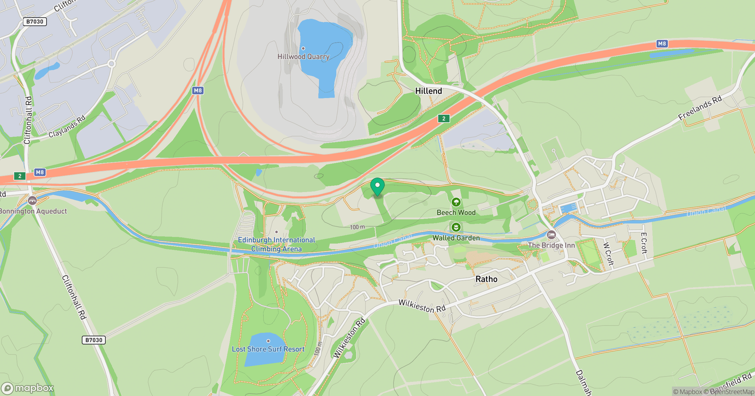
Grid reference: NT131710
View on OpenStreetMapOpens a map in a new tab, centred on the hill.
No comments yet. Be the first.