

Corstorphine Hill
Good walks are even better shared.
NT2073 : Woodland, Corstorphine Hill
Richard Webb Photo source
Overview
Corstorphine Hill is a wooded local nature reserve in western Edinburgh and one of the city's traditional Seven Hills. Its recorded 164.4 m high point is a rock on the northern ridge. Clermiston Tower and the Rest-and-be-Thankful viewpoint are separate landmarks.
Corstorphine Hill
Corstorphine Hill is a wooded local nature reserve in western Edinburgh. The retained DoBIH record identifies its northern rock summit at NT 20578 74152 as 164.4 m, with a southern top 0.6 m lower. Clermiston Tower is farther south at NT 20644 73839. Rest-and-be-Thankful is another distinct viewpoint.
A returning woodland walk
The route-planning note describes a complete circuit from Queensferry Road, visiting Rest-and-be-Thankful and Clermiston Tower before returning north along the ridge to its starting entrance. Walkhighlands publishes 4.5 km, 1–1.5 hours and 124 m ascent. The range remains in prose; there is no single estimated time. The route does not establish passage over the exact northern summit rock. Use its linked full directions and a detailed map.
Terrain and safety
Expect steps, uneven woodland paths and steep sections. Mud and exposed rock may be slippery, especially after rain or frost. Keep clear of quarry drops, respect fences and follow current notices. The many path junctions make navigation important.
Access and facilities
Car parks are reached from Clermiston Road North and Kaimes Road near Cairnmuir Road. There is no parking at the Queensferry Road circuit entrance. Allow separately for the approach from a car park. Lothian lists services 1 to Clermiston and 26 to Clerwood; check the operator's planner for the chosen entrance and travel date.
The reserve has a walled garden, seating, information panels, waymarked paths and orienteering. Do not depend on public toilets or refreshments in the woodland. Tower access is seasonal, supervised and weather-dependent; check the Friends of Corstorphine Hill before travelling.
Rocks, history and views
The hill is made from an intrusive dolerite sill, subsequently tilted and sculpted by glaciers. Exposed surfaces retain glacial scratches. Clermiston Tower commemorates Sir Walter Scott: it was built in 1871 and gifted to the city in 1932. Prehistoric cup markings and old quarries add to the hill's heritage.
Trees limit views from the ridge. Rest-and-be-Thankful overlooks Edinburgh; other viewpoints face the Forth and surrounding hills. The tower provides a broader outlook only when it is open.
Corstorphine's name has competing explanations. The council's historic appraisal includes Torfin's crossing as a possible derivation; certainty is unwarranted.
Explore routes near Corstorphine Hill
Walks starting near this hill. Open a route to check its map, distance and full itinerary.
To Absent Friends: Holyrood Park walk
View route
Artists’ walk in Craigmillar Castle Park (group meeting)
View route
East Calder: Almondell, Mandela Bridge and River Almond Circuit
View route
Dalkeith Country Park: Estate and North Woods Green Trail
View route
Route planning notes
These notes describe possible approaches. Check a route's map and access information when planning your walk.
Corstorphine Hill: Queensferry Road woodland circuit
Start and finish at the Queensferry Road reserve entrance (NT203751), where there is no parking. Take the lower path south through the woods, climbing the steps towards the zoo fence. Visit Rest-and-be-Thankful, then retrace to the fence junction. Continue towards Clermiston Tower, then follow ridge paths north, past the fenced quarry, to rejoin the outward path and return to Queensferry Road. Walkhighlands gives 4.5 km, 1–1.5 hours and 124 m ascent for this circuit. Its ridge itinerary does not identify the exact DoBIH summit rock; use a detailed map if that is your objective. Allow separately for any approach from the Clermiston Road North car park. Some sections are steep, muddy and slippery.
Make a day of it, together
Find someone to share the walk with, or organise a day out along a route you like.
Photo Gallery
View all Photo could not load
NT2073 : Woodland, Corstorphine Hill
Richard Webb
 Photo could not load
NT2074 : Former field, Clermiston
Richard Webb
 Photo could not load
NT2074 : Corstorphine Hill
Richard Webb
 Photo could not load
NT2074 : Northwest from Corstorphine Hill
Jim Barton
 Photo could not load
NT2074 : Boulder, Corstorphine Hill
Richard Webb
 Photo could not load
NT2074 : Steps to Craigcrook, Corstorphine Hill
Jim Barton
 Photo could not load
NT2074 : Corstorphine Hill
Callum Black
 Photo could not load
NT2074 : Woodland on Corstorphine Hill
Calum McRoberts
 Photo could not load
NT2074 : Woodland path, Corstorphine Hill
Jim Barton

NT2074 : Rock outcrop, Corstorphine Hill
Jim Barton
Hill facts and local notes
Classifications
Elevation
164m
539 ft
Prominence
119m
Coordinates
55.9539, -3.2735
NT205741
OS Map
66
Explorer: 350
At the Summit
DoBIH records a rock at NT 20578 74152, 164.4 m. Its southern summit at NT 20698 73820 is recorded as 0.6 m lower. Clermiston Tower stands farther south at NT 20644 73839. The tower and Rest-and-be-Thankful viewpoint are distinct from the northern high point; a trig point is not the recorded summit feature.
Terrain & Geology
A Carboniferous dolerite sill forms the hill: magma cooled beneath the surface between sedimentary rock layers. The resistant intrusion was tilted and later shaped by ice. Glacially smoothed rock and scratches are visible, and old quarries expose the rocks. The site is recognised for its local geodiversity.
Views & Scenery
Trees restrict views from much of the ridge. Rest-and-be-Thankful looks across Edinburgh, while other gaps and viewpoints overlook the Forth and surrounding hills. Clermiston Tower offers wider views when open. A panoramic outlook from the exact wooded summit is not guaranteed.
History & Heritage
Name Origin
The origin of Corstorphine is uncertain. Edinburgh's conservation-area appraisal suggests Gaelic crois torfin, meaning Torfin's crossing, among the proposed explanations. It does not support the claim that the name means hill of the nose.
Historical Significance
Clermiston Tower was built in 1871 to mark the centenary of Sir Walter Scott's birth and was given to Edinburgh in 1932. It is a Category B listed building. Prehistoric cup markings on the hill's western slopes are thought to be Neolithic or Bronze Age, although their purpose is uncertain. Quarrying also shaped the hill.
Getting There & Facilities
Parking
Small car parks serve the hill from Clermiston Road North and at the top of Kaimes Road by the end of Cairnmuir Road. The Queensferry Road circuit starts at a pedestrian entrance with no parking; allow for the additional walk from a car park. Follow current signs and restrictions.
Public Transport
Lothian's timetable lists service 1 to Clermiston and service 26 to Clerwood, useful for western-side approaches. The Queensferry Road circuit has a different start: plan that journey separately using the operator's journey planner. Check current stops, times and diversions before travel.
Nearby Facilities
The reserve has seating, interpretation panels, a walled garden, waymarked paths, an orienteering course and small car parks. Do not rely on finding a visitor centre, public toilets or refreshments within the reserve. Tower access is seasonal and volunteer-run; check Friends of Corstorphine Hill for current openings before travelling.
Safety Information
Known Hazards
- Woodland paths include steps and steep sections; wet rock, mud and roots can be slippery.
- Keep away from quarry drops and steep rock faces, stay outside fenced areas and obey local signs.
- The ridge has many branching paths. Carry a detailed map, especially if seeking the precise northern summit rock.
Seasonal Hazards
Rain can leave mud and slippery rock under the trees; frost can add ice. These are condition-dependent precautions rather than a report of current conditions. Tower access depends on its seasonal opening programme and the weather.
General Safety Tips
- Check weather conditions before setting out
- Carry appropriate clothing and equipment
- Let someone know your planned route
- Take a map, compass, and GPS device
- Carry emergency supplies: food, water, first aid kit, torch
Hills
Some common questions about the hills answered
Are there group walks up Corstorphine Hill?
Many walkers use Walkmates to join or organise walks with others. You can check for group walks around Corstorphine Hill through the maps
Are there other walkers around Corstorphine Hill?
Activity varies by location and time, but Walkmates lets you see whether others have shared walks or shown interest in this area. Find other people through the walking friends search walking friends for Corstorphine Hill search or of course create your own walk for Corstorphine Hill
Can I organise a walk to Corstorphine Hill?
Yes. If there aren’t any walks listed already, you can create a walk and make it available for others to join.
If you're signed up to Walkmates, you can create a walk to Corstorphine Hill.
How do I find a walk up this hill?
There are often multiple ways to walk this hill, depending on experience and route preference. Walkmates helps you explore walks and routes that others have shared.
Can I suggest a new route up Corstorphine Hill?
Yes. You can suggest or create routes to share with others. Walkmates focuses on the social side of walking, so routes are used to help people organise walks and explore areas together, rather than as detailed navigation tools or route libraries.
Other uses really appreciate knowledgeable walkers sharing their routes. Share your favourite route to Corstorphine Hill here
The is an error or something incorrect about this hill. How do I let you know?
We always strive to keep the information on Walkmates as accurate as possible. If you find an error, please let us know through the contact form and we'll aim to correct it as quickly as possible
Community Discussion
Comments
Location
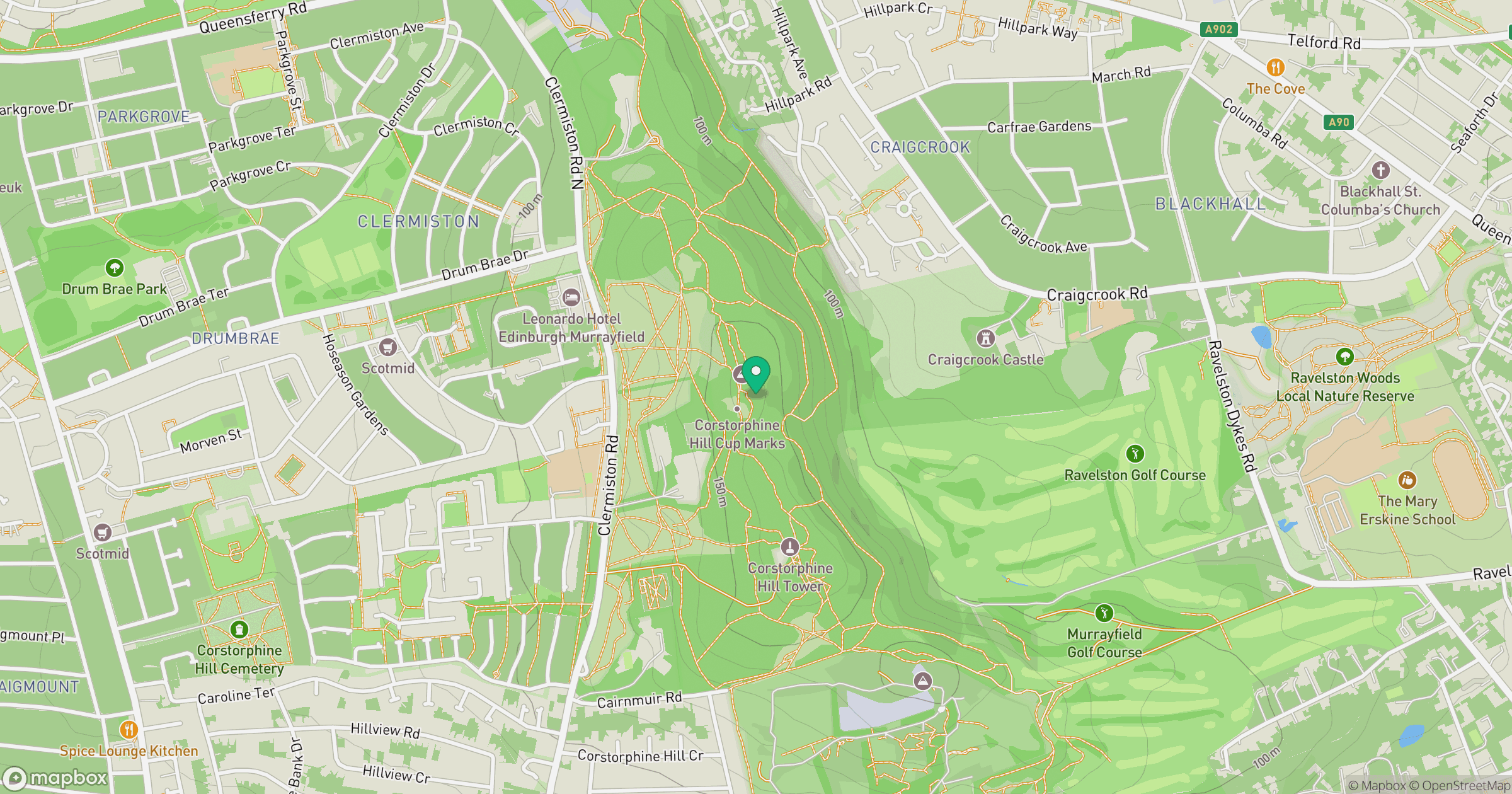
Grid reference: NT205741
View on OpenStreetMapOpens a map in a new tab, centred on the hill.
No comments yet. Be the first.