

Arthur's Seat
Good walks are even better shared.
NT2772 : Arthur's Seat from Bruntsfield Links
kim traynor Photo source
Overview
Arthur’s Seat is a 251 m volcanic hill in Edinburgh’s Holyrood Park, with wide views over the city and Firth of Forth. Compare the north-side path, Salisbury Crags circuit, steep Zigzag path and Dunsapie Loch approach. The summit is rocky and exposed, and road and path restrictions can affect your plans.
Arthur's Seat
Arthur’s Seat rises to 251 m in Holyrood Park, close to Edinburgh’s Royal Mile. The rocky summit looks across the Old Town and Edinburgh Castle towards the Firth of Forth. Its modest height makes it easy to fit into a city visit, but the upper paths are steep and uneven: choose a route that suits your footing and the weather.
Choose your walk
- Salisbury Crags and the summit: Walkhighlands’ 4.75 km circuit combines the top of the crags, the steep zigzag ascent and a return through Whinny Hill to St Margaret’s Loch. Allow the guide’s 2–2.5 hours. Stay back from the clifftop; this is not the Radical Road beneath it.
- North-side circuit: Countryfile’s 4 km route starts at Broad Pavement by Holyrood Palace, passes near St Anthony’s Chapel and returns on the grassy path west of Whinny Hill. Its estimate is two hours. Expect mud below and rock near the summit.
- The Hawse and Zigzag path: the official park guide gives 25 minutes from The Hawse to the summit. That is one-way, not a complete outing from a car park. The stone-pitched ascent is steep; keep to the built path towards Nether Hill.
- Dunsapie Loch: this eastern start reduces the amount of climbing, once you have reached the loch. Geowalks describes steep grass and rock, so short does not mean level or step-free. Return by the same path and include the walk to Dunsapie when planning your day.
- Sunrise: use a familiar summit route, such as the north-side path near St Anthony’s Chapel, and return the same way. Carry a headtorch and warm clothing, check the forecast and avoid shortcuts in the dark. A dawn visit is a timing choice, not a separate waymarked trail.
The official guide also gives 45 minutes from the main car park to the summit by the Summit path. Both official times are ascent estimates; allow for stops and descent. Use the linked route map for the particular walk you choose.
Access and closures
Checked 15 October 2026: HES lists the northern Radical Road below Salisbury Crags as fenced off for rockfall safety, while the southern section from The Hawse to the South Quarry and Hutton’s Section is accessible. Do not plan a through-walk beneath the crags or cross barriers. Check HES’s park management guidance and signs on arrival; the summit approaches above do not require the closed northern section.
The High Road was closed to motor vehicles when checked, although pedestrians and dismounted cyclists could use it. Do not assume you can drive to Dunsapie Loch. Broad Pavement, St Margaret’s Loch and Duddingston Loch are alternative parking locations, subject to current restrictions. Check roads and car parks before travelling, especially for weekends and events.
Holyrood Park is free to visit. Walk down the Royal Mile to the Holyrood entrance, or plan public transport to a convenient park entrance. Toilets are beside the Education Centre on the north side, behind Holyrood Palace, with seasonal opening hours. Bring water and arrange refreshments around the city before or after the walk. Plan your visit
A volcano, and a different kind of crag
Arthur’s Seat is the eroded core of an extinct volcano active about 342 million years ago. Basalt lava, volcanic ash and agglomerate record successive eruptions; later erosion and ice removed much of the original cone. Salisbury Crags are a separate, younger dolerite intrusion that solidified between existing rock layers. At Hutton’s Section, the contact with sedimentary rocks helped James Hutton explain how molten rock had entered older strata. British Geological Survey · Edinburgh Geological Society
People and the park
Holyrood Park preserves prehistoric or early historic forts, old cultivation terraces and medieval remains. James V enclosed the royal park in 1541–42. The summit sits within this protected archaeological landscape, so stay on established paths and leave stones and artefacts where they are. Historic Environment Scotland’s monument record
The name is traditionally linked to King Arthur, but that association belongs to folklore rather than a proven derivation. Royal Geographical Society
Underfoot and on the skyline
Wet rock, mud, steep steps and unguarded drops need care. Strong wind can make the summit uncomfortable or unsafe; ice makes a short climb considerably more serious. Wear grippy footwear, keep away from edges and turn back if conditions exceed your experience. The summit paths are unsuitable for wheelchairs and pushchairs; choose a lower park walk instead. Follow dog-control signs and take litter away. HES visitor safety and park rules
Reviewed 15 October 2026.
Explore routes near Arthur's Seat
Walks starting near this hill. Open a route to check its map, distance and full itinerary.
To Absent Friends: Holyrood Park walk
View route
Artists’ walk in Craigmillar Castle Park (group meeting)
View route
Dalkeith Country Park: Estate and North Woods Green Trail
View route
East Calder: Almondell, Mandela Bridge and River Almond Circuit
View route
Route planning notes
These notes describe possible approaches. Check a route's map and access information when planning your walk.
Summit circuit via Salisbury Crags
From Broad Pavement near Holyrood Palace, take the path behind Salisbury Crags and climb to their top, keeping back from the cliff edge. Continue to the steep zigzag summit path, then return through Whinny Hill and past St Margaret’s Loch. Walkhighlands gives 2–2.5 hours for this circuit. The clifftop route is different from the restricted Radical Road below.
Zigzag summit path from The Hawse
From The Hawse at the south end of Salisbury Crags, climb the steep stone-pitched zigzags towards Nether Hill, then continue to Arthur’s Seat. HES gives 25 minutes from The Hawse to the summit only; allow extra time for reaching the start and descending. Follow the built path rather than rocky shortcuts. Do not use the closed northern Radical Road to reach this ascent.
Dunsapie Loch approach
From Dunsapie Loch on the east side, follow the steep grassy and rocky paths uphill to the shoulder below the summit, then continue over rock to the top. Return the same way. This is a short ascent once at the loch, but it still has steep ground. Check HES road notices before planning a drive-up start; the High Road was closed to motor traffic on 15 October 2026.
Arthur’s Seat and Whinny Hill circular
From Broad Pavement, take the north-side summit path near St Anthony’s Chapel and climb the rocky upper section. Descend to the path junction and continue along the grassy, gorse-lined path west of Whinny Hill, returning past St Margaret’s Loch. This follows Countryfile’s 4 km circuit; lower paths can be muddy and the summit windy.
Sunrise summit walk via the north-side path
A dawn outing on the normal summit path, rather than a separate trail: start at Broad Pavement, pass near St Anthony’s Chapel and return the same way. Learn the route in daylight first, carry a headtorch and warm layers, and leave time for a careful descent. Avoid steep shortcuts in darkness and postpone the summit in strong wind or ice. Sunrise views depend on the weather.
Make a day of it, together
Find someone to share the walk with, or organise a day out along a route you like.
Photo Gallery
View all Photo could not load
NT2772 : Approaching Arthur's Seat
Iain Russell
 Photo could not load
NT2772 : Flush bracket bench mark, Arthur's Seat trig pillar
Mark Anderson
 Photo could not load
NT2772 : Trig pillar, Arthur's Seat
Mark Anderson
 Photo could not load
NT2772 : Arthur's Seat from Salisbury Crags
Richard Law
 Photo could not load
NT2772 : Arthur's Seat summit
Stephen Sweeney
 Photo could not load
NT2772 : Arthur's Seat
Richard Webb
 Photo could not load
NT2772 : Arthur's Seat
Richard Webb
 Photo could not load
NT2772 : The summit, Arthur's Seat
Richard Webb
 Photo could not load
NT2772 : Arthur's Seat and Salisbury Crags
M J Richardson
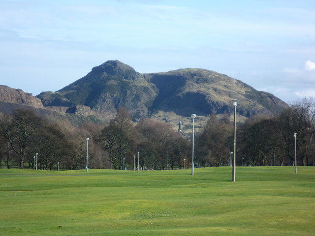
NT2772 : Arthur's Seat from Bruntsfield Links
kim traynor
Hill facts and local notes
Classifications
Elevation
251m
823 ft
Prominence
174m
Coordinates
55.9441, -3.1618
NT275729
OS Map
66
Explorer: 350
At the Summit
A rocky summit with a trig point and panoramic city views. DoBIH identifies the highest natural feature as rock beside the trig point, rather than the pillar itself. Take care on the uneven rock and keep away from steep edges.
Terrain & Geology
Arthur’s Seat is the eroded core of an extinct volcano active about 342 million years ago. Its rocks include basalt lava flows, volcanic ash and agglomerate within the old vent. Salisbury Crags are a younger dolerite sill intruded into sedimentary rocks, rather than the main rock of Arthur’s Seat. Later erosion and glaciation shaped the present hills and valleys.
Views & Scenery
In clear weather, look across Edinburgh’s Old Town and Castle, Holyrood Palace and the Scottish Parliament, with the Firth of Forth, Fife and the East Lothian coast beyond.
History & Heritage
Name Origin
The name is traditionally associated with King Arthur in folklore. This is not a securely established derivation, and the hill should not be presented as a proven site of Arthur’s court or Camelot.
Historical Significance
Holyrood Park contains four prehistoric or early historic forts, including remains on Arthur’s Seat, as well as cultivation terraces and medieval features. James V enclosed the royal park in 1541–42. The wider park is a Scheduled Monument. The rocks at nearby Hutton’s Section helped James Hutton interpret the intrusion of molten rock into older sedimentary layers.
Getting There & Facilities
Parking
Broad Pavement near Holyrood Palace is the start for the main north-side walks; St Margaret’s Loch and Duddingston Loch are alternatives. Check HES road and car-park notices before travelling. On 15 October 2026 the High Road was closed to motor traffic, so do not assume vehicle access to the Dunsapie Loch start. Weekend, event and maintenance restrictions can affect access; overnight parking is not permitted. Current notices: https://www.historicenvironment.scot/visit/all/holyrood-park/roads-and-car-parks/
Public Transport
Holyrood Park can be reached on foot down the Royal Mile, beside Holyrood Palace and the Scottish Parliament. Buses serve streets around several park entrances; choose the entrance for your route and check current services and the return journey with Traveline Scotland. The onward climb starts within the park.
Nearby Facilities
Public toilets are next to Holyrood Park Education Centre on the north side, behind Holyrood Palace; opening hours vary by season. Bring drinking water and plan food or café stops in Edinburgh before or after the walk. Check current toilet hours in HES’s visitor information. The rocky summit routes are not step-free.
Safety Information
Known Hazards
- Steep, uneven summit rock and stone steps can be slippery when wet; wear footwear with good grip.
- Strong wind can make the summit and Salisbury Crags clifftop hazardous. Keep well back from unguarded edges.
- Do not cross rockfall barriers or use the closed northern Radical Road as a through-route. Check HES notices and local signs.
- Lower paths can be muddy. Several paths converge near the summit; plan your descent and carry a headtorch if darkness is possible.
Seasonal Hazards
Ice and snow can make the rocky summit and steps difficult even when city streets are clear. Short winter days and pre-dawn starts add navigation and exposure risks. In dry weather, follow fire warnings; fires and barbecues are not permitted in Holyrood Park.
General Safety Tips
- Check weather conditions before setting out
- Carry appropriate clothing and equipment
- Let someone know your planned route
- Take a map, compass, and GPS device
- Carry emergency supplies: food, water, first aid kit, torch
Hills
Some common questions about the hills answered
Are there group walks up Arthur's Seat?
Many walkers use Walkmates to join or organise walks with others. You can check for group walks around Arthur's Seat through the maps
Are there other walkers around Arthur's Seat?
Activity varies by location and time, but Walkmates lets you see whether others have shared walks or shown interest in this area. Find other people through the walking friends search walking friends for Arthur's Seat search or of course create your own walk for Arthur's Seat
Can I organise a walk to Arthur's Seat?
Yes. If there aren’t any walks listed already, you can create a walk and make it available for others to join.
If you're signed up to Walkmates, you can create a walk to Arthur's Seat.
How do I find a walk up this hill?
There are often multiple ways to walk this hill, depending on experience and route preference. Walkmates helps you explore walks and routes that others have shared.
Can I suggest a new route up Arthur's Seat?
Yes. You can suggest or create routes to share with others. Walkmates focuses on the social side of walking, so routes are used to help people organise walks and explore areas together, rather than as detailed navigation tools or route libraries.
Other uses really appreciate knowledgeable walkers sharing their routes. Share your favourite route to Arthur's Seat here
The is an error or something incorrect about this hill. How do I let you know?
We always strive to keep the information on Walkmates as accurate as possible. If you find an error, please let us know through the contact form and we'll aim to correct it as quickly as possible
Community Discussion
Comments
Location
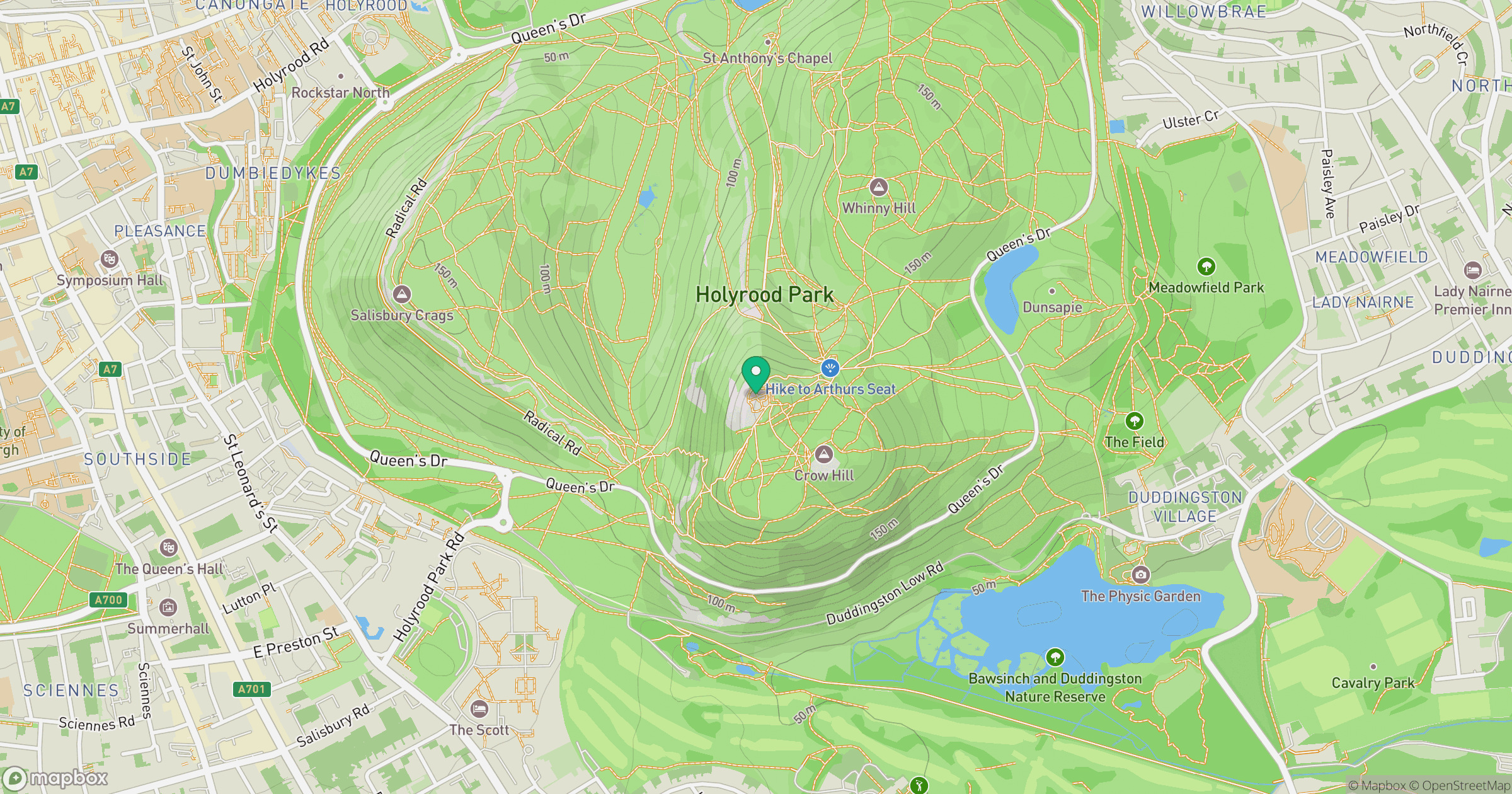
Grid reference: NT275729
View on OpenStreetMapOpens a map in a new tab, centred on the hill.
No comments yet. Be the first.