

Nine Standards Rigg
Good walks are even better shared.
NY8205 : Restoration of peat bog, Nine Standards Rigg
Andrew Curtis Photo source
Overview
Nine Standards Rigg is a 661.9 m Pennine fell east of Kirkby Stephen, with 159 m of prominence. Its nine drystone cairns stand on a lower skyline north of the trig point; the unmarked highest ground is 20 m southeast of the trig. Town and railway-station circuits cross Hartley Fell, with broad views over the Eden Valley.
Nine Standards Rigg
Nine Standards Rigg is a 661.9 m Pennine fell east of Kirkby Stephen, with 159 m of prominence. It is a Marilyn, Simm, Hewitt and Nuttall. The nine drystone cairns stand on a lower skyline roughly 500 m north of the trig point. The unmarked highest ground is at NY8255906096, 20 m southeast of the trig.
Routes
Kirkby Stephen station circuit
Start and finish at the railway station. The outward line goes through Nateby and Ladthwaite, then climbs Hartley Fell and Faraday Gill to the cairns and trig. Return by Birkett Lane, Hartley Quarry, the railway viaducts, Stenkrith and Halfpenny House. Skyware’s complete station circuit is 18 km with 720 m ascent, taking 5 hours 45 minutes, and is graded strenuous. Its published itinerary visits the trig; the natural summit is a short distance southeast. Road sections, stiles and boggy fell paths require care.
Kirkby Stephen town circuit
From the market square, cross Frank’s Bridge and walk via Podgill, Ewbank Scar and Ladthwaite, beneath Birkett Hill. Join Birkett Lane, then climb beside Faraday Gill to the cairns and trig. Return down Birkett Lane past Hartley Quarry, through Hartley village and across Frank’s Bridge to the market square. This is the guide’s separate town variant. Respect farm privacy and use the signed paths.
A Coast to Coast continuation towards Keld is a separate linear journey requiring its own finish and onward travel arrangements. The Coast to Coast became a National Trail on 26 March 2026. Natural England confirms new flagstones over Nine Standards Rigg and White Mossy Hill. Minutes of the North Yorkshire Local Access Forum meeting on 24 September 2025 report that flagging had been completed and that the National Park Authority requested exclusive use of the fully flagged red route. This supersedes older seasonal red/blue/green rotation advice. Follow current waymarks and local notices.
Landscape and views
Carboniferous sedimentary rocks underlie the fell, including limestone, shale and sandstone. Deep peat covers much of the surrounding moor, while broken flagstone and sandstone litter parts of the ridge. Clear-weather views from the cairns extend across the Eden Valley towards the Howgills, Lake District and northern Pennines; Wild Boar Fell stands across Mallerstang. Visibility depends on the weather rather than a guaranteed season.
Access and facilities
Christian Head and Stoneshot offer free long-stay town parking; Christian Head has a 2.1 m height limit. The railway station is a separate start outside town. Northern lists a station car park, but check its permitted use before leaving a car for a walk. Choose parking for your intended circuit and keep farm entrances clear.
Northern trains serve Kirkby Stephen on the Settle–Carlisle line. Stagecoach 563 links Penrith with Kirkby Stephen town and station; check current journey patterns, exact stops and last returns. There are public toilets at Stoneshot and refreshments in town. The railway station has no toilets. Carry food, water and hill equipment.
Terrain and safety
The climb crosses exposed moorland with wet peat, uneven paths and little shelter. New flagstones improve the Coast to Coast crossing but do not make all approaches dry or remove the need for navigation. Mist can obscure the cairns and path junctions; carry a current map and compass and know how to use them. Allow enough daylight for the full return.
Wet weather increases mud and boggy conditions; frost, ice or snow can make paths and stone surfaces slippery. Take suitable layers and waterproofs, check the forecast and leave gates as found. Use care on the B6270 verge and narrow lanes. The viaduct return uses permissive paths managed by Northern Viaduct Trust. Check council and National Park access notices, including open-access land restrictions, before travel and follow local signs.
History and surroundings
Historic England lists the nine cairns at Grade II and records a mention in 1635. They cross the boundary between Hartley and Winton parishes, but their original purpose and construction date remain uncertain. Do not climb or dismantle the cairns.
Nearby Wild Boar Fell (708.4 m) and Great Shunner Fell (715.7 m) are separate summits requiring their own route plans. The River Eden, Stenkrith, Ewbank Scar and the former railway viaducts add interest to the lower approaches.
Explore routes near Nine Standards Rigg
Walks starting near this hill. Open a route to check its map, distance and full itinerary.
Barnard Castle: Flatts Wood and Cleveland Walk
View route
Buckden Pike Wellington Wreckage and Memorial
View route
Pen-y-ghent from Horton in Ribblesdale
View route
Yorkshire Three Peaks Challenge – Gentle Pace
View route
Route planning notes
These notes describe possible approaches. Check a route's map and access information when planning your walk.
Nine Standards Rigg from Kirkby Stephen station
Start and finish at Kirkby Stephen railway station. Walk via Halfpenny House and Nateby, then take the B6270 verge and Ladthwaite path to Birkett Lane. Climb Hartley Fell beside Faraday Gill to the cairns and continue south to the trig. Retrace to Birkett Lane, descend past Hartley Quarry, then return over the railway viaducts via Stenkrith and Halfpenny House. Skyware gives 18 km, 720 m ascent and 5 hours 45 minutes for this complete circuit to the trig; the natural summit lies 20 m southeast of it. Expect boggy sections, stiles and road walking.
Nine Standards Rigg from Kirkby Stephen town
Begin and finish in Kirkby Stephen market square. Cross Frank’s Bridge and follow the Podgill and Ewbank Scar paths to Ladthwaite, passing beneath Birkett Hill. Join Birkett Lane and ascend Hartley Fell and Faraday Gill to the cairns, continuing south to the trig. Return down Faraday Gill and Birkett Lane, then descend past Hartley Quarry through Hartley village and cross Frank’s Bridge back to town. This is Skyware’s separate town circuit, with woodland steps, stiles and exposed moorland.
Make a day of it, together
Find someone to share the walk with, or organise a day out along a route you like.
Photo Gallery
View all Photo could not load
NY8205 : Restoration of peat bog, Nine Standards Rigg
Andrew Curtis
 Photo could not load
NY8206 : Winter at Nine Standards Rigg
David Brown
 Photo could not load
NY8205 : Peat haggs near Baxton Gill Head
Trevor Littlewood
 Photo could not load
NY8206 : Trig point above Nine Standards
Colin
 Photo could not load
NY8206 : Trig Point and The Nine Standards
Anthony Parkes
 Photo could not load
NY8206 : Trig Point, Nine Standards Rigg
Andrew Curtis
 Photo could not load
NY8206 : Trig point, Nine Standards Rigg
Ian Taylor
 Photo could not load
NY8206 : Trig Pillar, Nine Standards Rigg
Michael Graham
Hill facts and local notes
Classifications
Elevation
662m
2,172 ft
Prominence
159m
Coordinates
54.4500, -2.2705
NY825060
OS Map
91 92
Explorer: OL19S
At the Summit
The natural summit is unmarked ground at NY8255906096, 20 m southeast of the trig point at NY8254406109. The nine drystone cairns stand on a lower ridge roughly 500 m north of the trig; a viewpoint and viewfinder lie between the cairns and trig.
Terrain & Geology
Carboniferous sedimentary rocks underlie the fell, including limestone, shale, flagstone and sandstone. Deep peat covers much of the surrounding moorland, while broken flagstone and sandstone blocks litter the ridge. Faulting complicates the local sequence; the cairns are human-built drystone structures.
Views & Scenery
In clear weather the cairns overlook the Eden Valley, the Howgills, the Lake District fells and the northern Pennines. From the ridge, Wild Boar Fell rises across Mallerstang. The cairns stand below the true summit and views east are more restricted.
History & Heritage
Name Origin
The name refers to the group of nine drystone cairns on the northern skyline. They occur in historic boundary records, but their original purpose and construction date are uncertain.
Historical Significance
The nine drystone cairns are a Grade II listed group. Historic England records them crossing the Hartley–Winton parish boundary and mentions a documentary reference from 1635. This establishes their historical presence, not a known construction date.
Getting There & Facilities
Parking
Christian Head and Stoneshot in Kirkby Stephen provide free long-stay town parking; Christian Head has a 2.1 m height limit. Northern lists a car park at the separate railway station, but check its permitted use before leaving a car for a walk. Choose the start for your intended circuit and keep narrow lanes and farm entrances clear.
Public Transport
Northern trains serve Kirkby Stephen on the Settle–Carlisle line; the station is outside the town and starts the station circuit. Stagecoach 563 links Penrith with Kirkby Stephen town and station. Journey patterns and operating days vary, so check current rail and bus timetables, the exact stop and last return before setting out.
Nearby Facilities
Kirkby Stephen has shops, cafés and pubs, with public toilets at Stoneshot. The railway station has no toilets. Use town facilities before the walk and carry food and water for the exposed fell.
Safety Information
Known Hazards
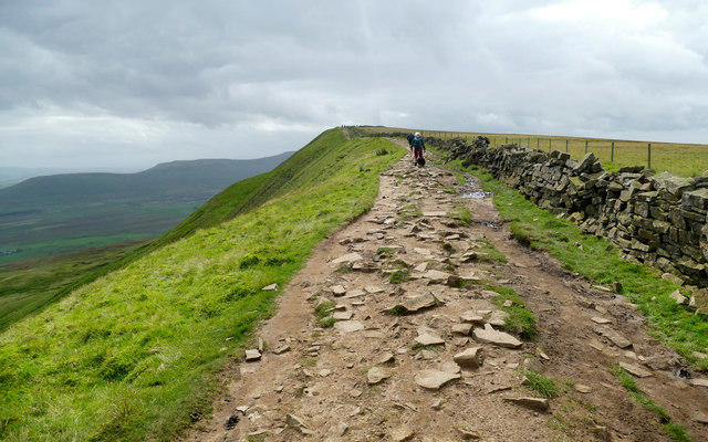
- Wet peat and boggy sections remain on the fell approaches; keep to established paths and the new flagged Coast to Coast line where provided.
- Mist can obscure the cairns and path junctions on the broad, exposed moor. Carry a current map and compass and suitable clothing.
- The station circuit includes the B6270 verge and narrow lanes; take care around traffic, stiles and uneven woodland steps.
- Treat the drystone cairns with care: do not climb them or move stones. Respect farm privacy and leave gates as found.
Seasonal Hazards
Rain can deepen mud and bogs. Frost, ice and snow can make paths and flagstones slippery, while wind and short winter days increase the demands of a full circuit. Use current Coast to Coast waymarks and local notices; older seasonal red/blue/green rotation advice has been superseded.
General Safety Tips
- Check weather conditions before setting out
- Carry appropriate clothing and equipment
- Let someone know your planned route
- Take a map, compass, and GPS device
- Carry emergency supplies: food, water, first aid kit, torch
Hills
Some common questions about the hills answered
Are there group walks up Nine Standards Rigg?
Many walkers use Walkmates to join or organise walks with others. You can check for group walks around Nine Standards Rigg through the maps
Are there other walkers around Nine Standards Rigg?
Activity varies by location and time, but Walkmates lets you see whether others have shared walks or shown interest in this area. Find other people through the walking friends search walking friends for Nine Standards Rigg search or of course create your own walk for Nine Standards Rigg
Can I organise a walk to Nine Standards Rigg?
Yes. If there aren’t any walks listed already, you can create a walk and make it available for others to join.
If you're signed up to Walkmates, you can create a walk to Nine Standards Rigg.
How do I find a walk up this hill?
There are often multiple ways to walk this hill, depending on experience and route preference. Walkmates helps you explore walks and routes that others have shared.
Can I suggest a new route up Nine Standards Rigg?
Yes. You can suggest or create routes to share with others. Walkmates focuses on the social side of walking, so routes are used to help people organise walks and explore areas together, rather than as detailed navigation tools or route libraries.
Other uses really appreciate knowledgeable walkers sharing their routes. Share your favourite route to Nine Standards Rigg here
The is an error or something incorrect about this hill. How do I let you know?
We always strive to keep the information on Walkmates as accurate as possible. If you find an error, please let us know through the contact form and we'll aim to correct it as quickly as possible
Community Discussion
Comments
Location
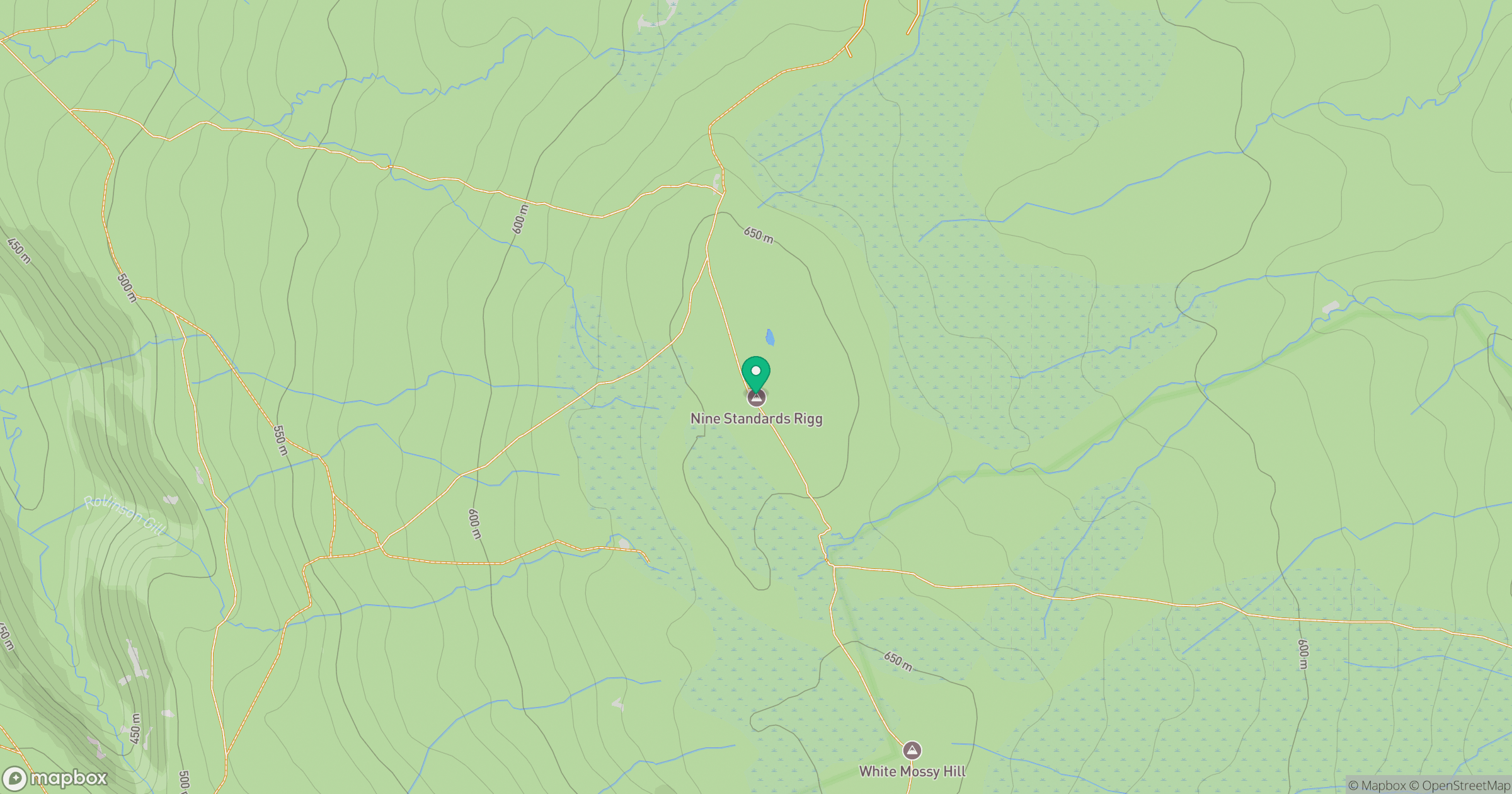
Grid reference: NY825060
View on OpenStreetMapOpens a map in a new tab, centred on the hill.
No comments yet. Be the first.