
Hartside Hill
Good walks are even better shared.
Overview
Hartside Hill: A Beacon of the North Pennines
Nestled in the scenic North Pennines, Hartside Hill boasts a respectable elevation of 593 meters, making it a prominent spot for hikers and nature lovers alike. Its accessibility and stunning vistas ensure that it remains a popular destination in the UK.
Geology
Hartside Hill's geological foundation is primarily carbonate-rich limestone and sandstone, a testament to its formation during the Carboniferous era. Hikers can observe unique rock formations and ancient fossils along the trails, a treasure trove for geology enthusiasts!
Routes
One of the most popular routes ascends from Melmerby, covering approximately 5 km and taking about two hours. It's a straightforward path, peppered with lovely views and friendly sheep who often look more interested in your sandwich than in the hike itself.
Summit Features
At the summit, you’ll find a solid trig point providing the perfect spot for a photo op, alongside a stone shelter that can provide a welcome break from the wind. If you’re lucky, you might catch sight of wildlife, so keep your eyes peeled!
Terrain Type
Expect varied terrain here! You will encounter grassy slopes, some rocky outcrops, and possibly a few boggy spots – always good for an unexpected splash if you’re not careful!
Views
The views from Hartside are nothing short of spectacular. On a clear day, you can see all the way to the Lake District and beyond. Spring and early autumn are particularly stunning months due to clear skies and vibrant colours.
Hazards
It’s essential to be mindful of potential hazards: slippery surfaces can be common, especially when the weather is less than delightful. Bring appropriate gear and keep an eye on the changing conditions.
Nearby Summits
If you're feeling particularly adventurous, consider venturing out to nearby peaks like Cross Fell and Little Fell, each offering their own unique experience and views.
Access & Facilities
Parking is available at the Hartside Cafe, and if you’re keen on public transport, be prepared for a bit of extra travel time from Alston. But rest assured, the facilities at the cafe provide a fantastic opportunity for refreshments and a chance to recount your hiking tales.
History
The name Hartside evokes images of stags frolicking in the wild, a nod to the rich biodiversity that once thrived here. Additionally, this hill has historical relevance due to its past quarrying activities, which shaped the region.
So pack your bags, lace-up those hiking boots, and make your way to Hartside Hill for an unforgettable outdoor adventure! Who knows, you might just be the next one to spot a stag on your climb.
Explore routes near Hartside Hill
Public walks starting within 80 km of this hill. Nearby does not mean a route reaches the summit; check its map and access before setting out.
Lauder Burn Mill and Chester Hill Circuit
View route
Pencaitland Railway Walk
View route
Dalkeith Country Park: Estate and North Woods Green Trail
View route
Earlston Diamond Jubilee Path to Leaderfoot
View route
Route planning notes
These notes describe possible approaches, not verified navigable routes or permission to cross land. Check current paths, local access rules and conditions before setting out.
Hartside Pass from Melmerby
A delightful route starting from Melmerby village, leading up through fields and along the wooded slopes towards the summit. This route is straightforward and well-marked, making it a favourite for families.
Make a day of it, together
Find someone to share the walk with, or organise a day out along a route you like.
Hill facts and local notes
Classifications
Elevation
468m
1,535 ft
Prominence
106m
Coordinates
55.7787, -2.8817
NT447542
OS Map
66 73
Explorer: 345W
At the Summit
The summit features a prominent trig point and a stone shelter which provides some respite from the breezy conditions often found at high altitudes. It's a classic spot for a selfie or just to take in the grandeur of the countryside.
Terrain & Geology
Hartside Hill is primarily composed of sedimentary rocks, including limestone and sandstone, which were formed during the Carboniferous period. These strata give the hill a rugged terrain and support diverse wildlife.
Views & Scenery
From the top, enjoy panoramic views of the North Pennines, the Lake District to the west, and the sweeping expanses of the Eden Valley. On a clear day, you might even spot the distant fells of Scotland.
History & Heritage
Name Origin
The name 'Hartside' is believed to derive from 'hart', an old English term for stag, possibly referencing the wildlife once prevalent in the area.
Historical Significance
Historically, the hill has been significant for quarrying during the 19th century, and the surrounding landscape is steeped in agricultural tradition.
Getting There & Facilities
Check current local access restrictions, parking rules and transport timetables before travelling. These notes do not confirm public access to the summit.
Parking
There is ample parking near the summit at Hartside Cafe, which offers stunning views and a good place to refuel post-hike.
Public Transport
Limited public transport options; the nearest bus stop is a few miles away in Alston. A car is highly recommended for convenience.
Nearby Facilities
Facilities include the Hartside Cafe at the summit, offering refreshments and restrooms. Alston also has several pubs and shops for pre or post-hike needs.
Safety Information
Known Hazards
- Potentially slippery conditions on wet grass and rocky sections. Weather can change rapidly, so be prepared for all seasons.
General Safety Tips
- Check weather conditions before setting out
- Carry appropriate clothing and equipment
- Let someone know your planned route
- Take a map, compass, and GPS device
- Carry emergency supplies: food, water, first aid kit, torch
Hills
Some common questions about the hills answered
Are there group walks up Hartside Hill?
Many walkers use Walkmates to join or organise walks with others. You can check for group walks around Hartside Hill through the maps
Are there other walkers around Hartside Hill?
Activity varies by location and time, but Walkmates lets you see whether others have shared walks or shown interest in this area. Find other people through the walking friends search walking friends for Hartside Hill search or of course create your own walk for Hartside Hill
Can I organise a walk to Hartside Hill?
Yes. If there aren’t any walks listed already, you can create a walk and make it available for others to join.
If you're signed up to Walkmates, you can create a walk to Hartside Hill.
How do I find a walk up this hill?
There are often multiple ways to walk this hill, depending on experience and route preference. Walkmates helps you explore walks and routes that others have shared.
Can I suggest a new route up Hartside Hill?
Yes. You can suggest or create routes to share with others. Walkmates focuses on the social side of walking, so routes are used to help people organise walks and explore areas together, rather than as detailed navigation tools or route libraries.
Other uses really appreciate knowledgeable walkers sharing their routes. Share your favourite route to Hartside Hill here
The is an error or something incorrect about this hill. How do I let you know?
We always strive to keep the information on Walkmates as accurate as possible. If you find an error, please let us know through the contact form and we'll aim to correct it as quickly as possible
Community Discussion
Comments
Location
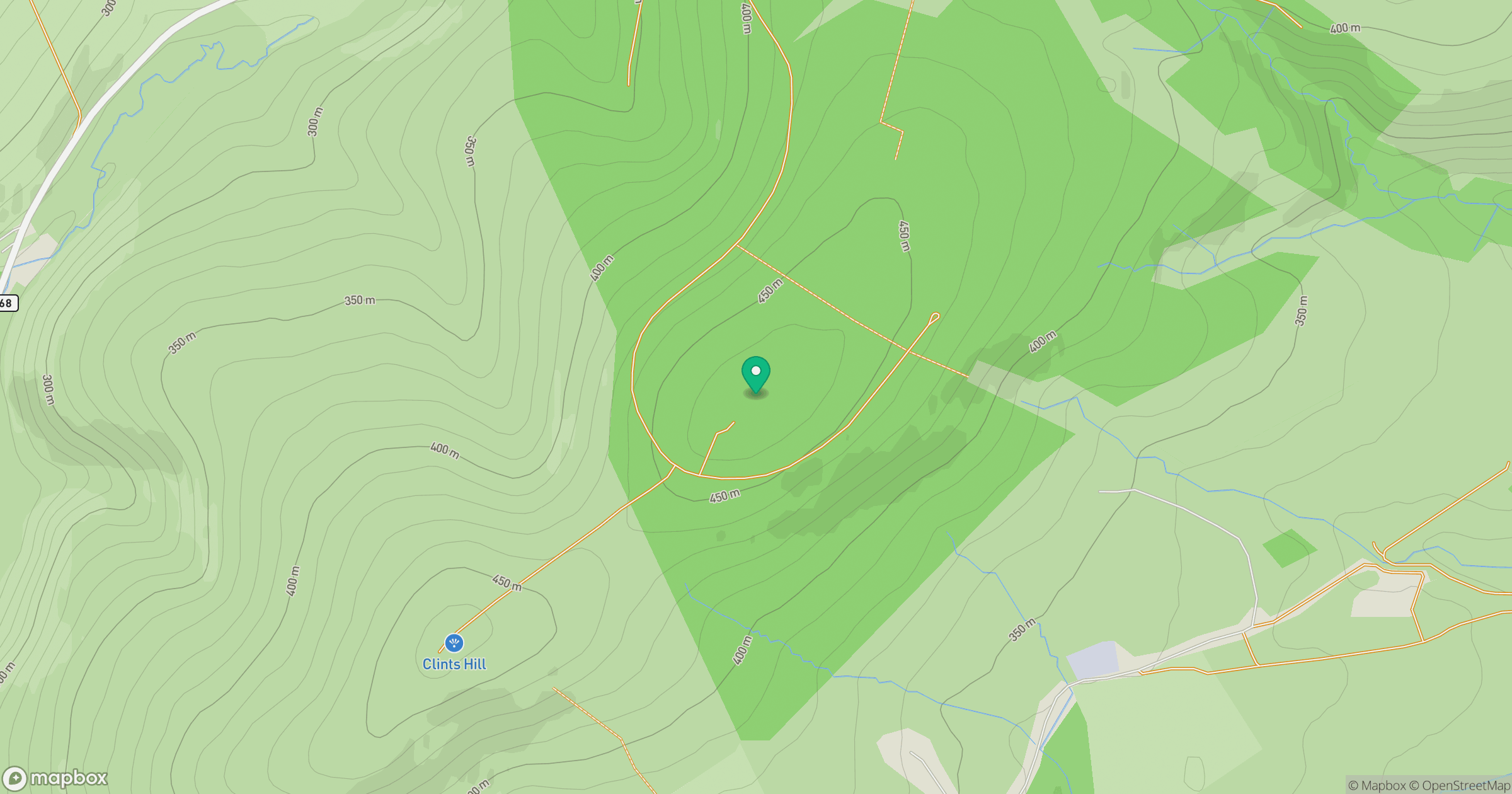
Grid reference: NT447542
View on OpenStreetMapOpens a map in a new tab, centred on the hill.
Hills within 30 km
Straight-line distance, not a walking route or confirmation of access.
No comments yet. Be the first.