
Craig Hill
Good walks are even better shared.
Overview
Craig Hill
Overview
Located in the picturesque Southern Uplands, Craig Hill stands majestically at an elevation of 521 meters. Classified as a Marilyn, it draws in hikers with its moderate yet rewarding trails and stunning panoramas.
Geology
The geological makeup of Craig Hill showcases Silurian sedimentary rocks, specifically mudstones and sandstones, that narrate the ancient Earth’s stories. If you're into geology, you'll love picking up the stones and imagining them as fossils of ancient sea beds.
Routes
From the A713 Road
This route is perfect for those looking to enjoy a bit of nature without facing an Olympic-level challenge. This 5.0 km trek takes roughly 2.5 hours, granting hikers a delightful experience as it winds through lush greenery before stepping up the game with some modest elevation gains. Remember to keep your eyes peeled for the occasional sheep, they’re great listeners!
Summit Features
At the very top, visitors will find a neat little cairn, alongside some delightful rocky outcrops that double as perfect perches for your lunch break or a contemplative moment. Don’t forget to bring a snack – those craggy benches can make for fine dining under the open sky!
Terrain
The terrain is primarily grassy, peppered with rocky bits that'll keep your feet on their toes – quite literally! The initial easy-going slopes are followed by a more rugged final push that will remind you that you’re not just walking in a park.
Views
The summit rewards effort with breathtaking views of the surrounding landscape. On a clear day, the rolling hills stretch out endlessly, and you might even spy the Galloway Forest Park shimmering in the distance. Spring and autumn are the finest seasons, bringing vibrant colours to the hills while keeping the weather less temperamental.
Hazards
Be mindful of the rocky terrain, especially when damp, as it can be slippery. And remember, the signal might cut out a bit, so make sure your hiking buddy isn’t your phone!
Nearby Summits
If you’re feeling adventurous, why not take a detour to Cairnsmore of Fleet, which tops out at 703 meters? A little friendly competition never hurt anybody!
Access
You’ll find informal parking right off the A713, just a short walk from the trailhead. For those relying on public transport, buses operate from Castle Douglas, which is about 10 miles away.
Facilities
While there are no facilities at Craig Hill itself, Castle Douglas boasts excellent cafés and public toilets, so plan your visit around a well-deserved post-hike snack.
History
The name 'Craig' denotes its rocky heritage and historical importance for local walkers, serving not just as a path to a summit but a cherished outing among the hills. So grab your gear, lace up your boots, and experience the charm of Craig Hill for yourself!
Conclusion
Craig Hill is a fantastic hike perfect for families and solo adventurers alike. Remember, the hills are alive with the sound of … well, your heavy breathing, but hey – it's worth every step! Enjoy your adventure!
Explore routes near Craig Hill
Public walks starting within 80 km of this hill. Nearby does not mean a route reaches the summit; check its map and access before setting out.
Selkirk Ettrick Water North Riverside Circuit
View route
Selkirk Haining Loch and Woodland Circuit
View route
Lindean Loch Nature Reserve Circuit
View route
Melrose to Newstead: River Tweed and Priorswalk
View route
Route planning notes
These notes describe possible approaches, not verified navigable routes or permission to cross land. Check current paths, local access rules and conditions before setting out.
From the A713 Road
A pleasant route beginning from the A713, meandering through lush greenery before climbing steadily to the summit.
Make a day of it, together
Find someone to share the walk with, or organise a day out along a route you like.
Hill facts and local notes
Classifications
Elevation
382m
1,255 ft
Prominence
144m
Coordinates
55.5945, -2.8878
NT441337
OS Map
73
Explorer: 338
At the Summit
The summit is crowned with a modest rock outcrop and a small cairn, perfect for a quick photo-op. If you squint just right, you might even see a pigeon trying to figure out why you're so sweaty.
Terrain & Geology
Craig Hill is predominantly composed of Silurian sedimentary rocks, particularly mudstones and sandstones, which give rise to its rugged appearance. These ancient formations provide a glimpse into the geological history of the region.
Views & Scenery
From the summit, you can marvel at the rolling hills of the Southern Uplands and catch distant glimpses of the Galloway Forest Park. With a clear sky, the views are sure to take your breath away - or maybe that's just the altitude!
History & Heritage
Name Origin
The name 'Craig' derives from the Gaelic word 'creag', meaning rock or crag, reflecting its rocky outcrops.
Historical Significance
Craig Hill holds a small place in the hearts of local walkers and is appreciated for its unassuming beauty and accessibility.
Getting There & Facilities
Check current local access restrictions, parking rules and transport timetables before travelling. These notes do not confirm public access to the summit.
Parking
There is informal parking available on the A713 just north of the trailhead.
Public Transport
Buses run from nearby towns; the nearest reliable service is from Castle Douglas.
Nearby Facilities
The nearest toilets are found in Castle Douglas, alongside several cafes to refuel after your hike. Plan wisely!
Safety Information
Known Hazards
- Spotty mobile reception in some areas, rocky terrain at the summit which can be tricky when wet.
General Safety Tips
- Check weather conditions before setting out
- Carry appropriate clothing and equipment
- Let someone know your planned route
- Take a map, compass, and GPS device
- Carry emergency supplies: food, water, first aid kit, torch
Hills
Some common questions about the hills answered
Are there group walks up Craig Hill?
Many walkers use Walkmates to join or organise walks with others. You can check for group walks around Craig Hill through the maps
Are there other walkers around Craig Hill?
Activity varies by location and time, but Walkmates lets you see whether others have shared walks or shown interest in this area. Find other people through the walking friends search walking friends for Craig Hill search or of course create your own walk for Craig Hill
Can I organise a walk to Craig Hill?
Yes. If there aren’t any walks listed already, you can create a walk and make it available for others to join.
If you're signed up to Walkmates, you can create a walk to Craig Hill.
How do I find a walk up this hill?
There are often multiple ways to walk this hill, depending on experience and route preference. Walkmates helps you explore walks and routes that others have shared.
Can I suggest a new route up Craig Hill?
Yes. You can suggest or create routes to share with others. Walkmates focuses on the social side of walking, so routes are used to help people organise walks and explore areas together, rather than as detailed navigation tools or route libraries.
Other uses really appreciate knowledgeable walkers sharing their routes. Share your favourite route to Craig Hill here
The is an error or something incorrect about this hill. How do I let you know?
We always strive to keep the information on Walkmates as accurate as possible. If you find an error, please let us know through the contact form and we'll aim to correct it as quickly as possible
Community Discussion
Comments
Location
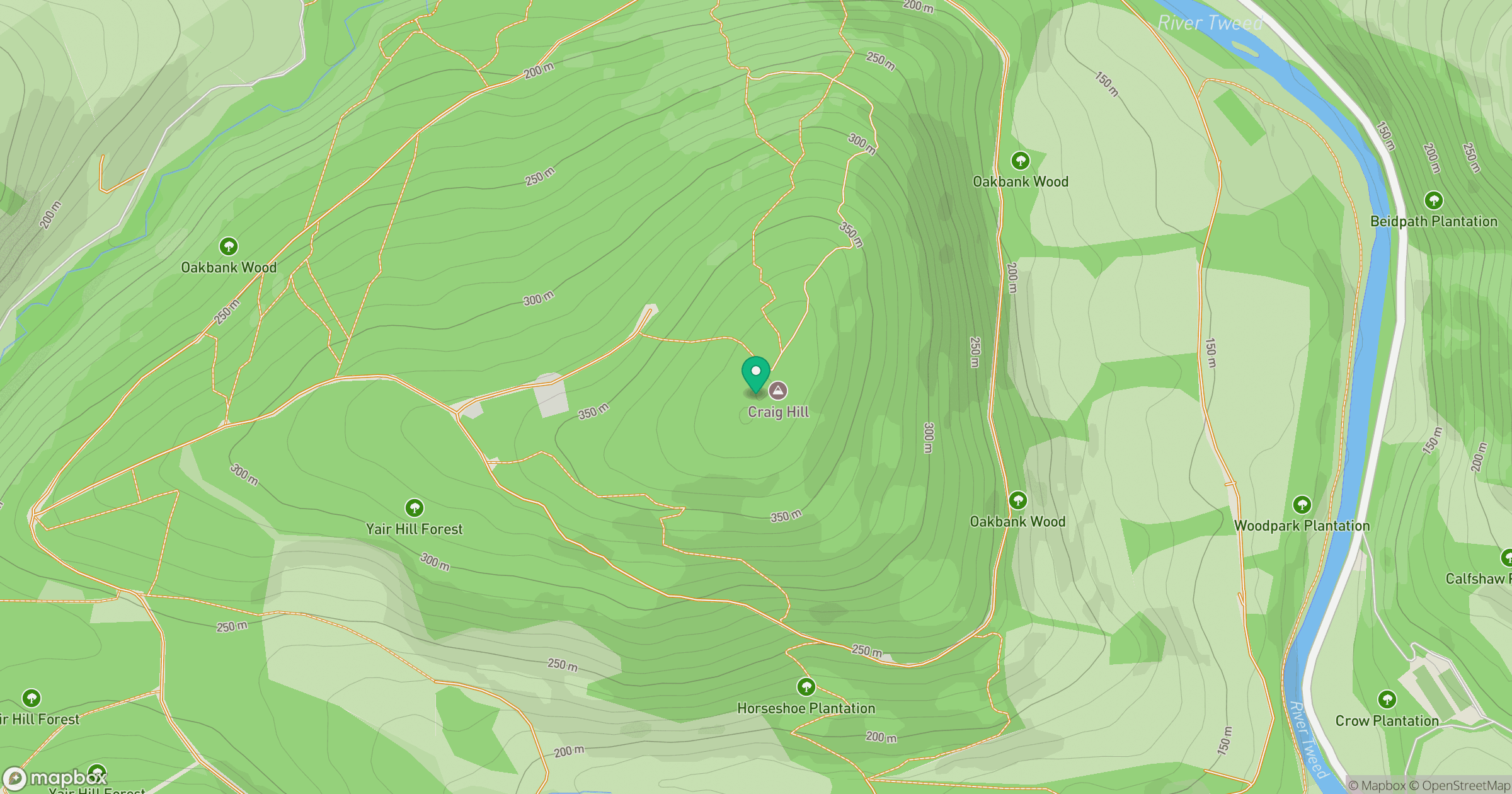
Grid reference: NT441337
View on OpenStreetMapOpens a map in a new tab, centred on the hill.
Hills within 30 km
Straight-line distance, not a walking route or confirmation of access.
No comments yet. Be the first.