

Lammer Law
Good walks are even better shared.
NT5261 : Filled in road, Lammer Law
Richard Webb Photo source
Overview
Lammer Law: A Hiker's Delight
Overview
Lammer Law, standing proudly at 609 meters, is a magnificent Marilyn located in the Southern Uplands. Known for its gentle slopes and stunning views, this hill offers a pleasant hike that is suitable for many levels of outdoor enthusiasts.
Geology
As you traverse its slopes, you'll notice that Lammer Law is primarily made up of andesitic volcanic rock, a remnant of the region's fiery past. The mix of grassy fields and rocky crags makes it a picturesque spot for both seasoned hikers and casual walkers.
Routes
One popular route is the Lammer Law Circular Route, starting at Longformacus. This moderate 8.5 km walk usually takes around 3 hours, allowing time to soak in the stunning landscapes along the way.
Summit Features
Reaching the summit is always a joy! Here, you'll find a trig point standing tall amidst a small cairn. Feel free to mark this summit in your hiking log—it's one worth bragging about!
Terrain Type
Expect a delightful mix of grassy slopes and rocky patches, but keep your eyes peeled for those sneaky boggy bits that can catch you off guard. A perfect reminder that nature always has a little surprise up its sleeve!
Views
Once at the top, bask in the panoramic views of the Southern Uplands, a sight sure to take your breath away (don’t worry, you’ll be back to lungfuls of air in no time)! The best seasons to enjoy these views are late spring and early autumn, when the colours are vibrant and the skies typically clearer.
Hazards
While the hike is enjoyable, it’s important to remain cautious. The weather can change faster than a squirrel on espresso, so pack an extra layer. Also, have your waterproof boots at the ready—the Scottish countryside loves a good splash!
Nearby Summits
Don’t forget to check out nearby peaks like Herdmanston Hill and Braid Law. Each offers its own unique charm and stunning vistas.
Access
Getting to Lammer Law is straightforward. There is a small parking area at Longformacus, just 10 minutes from the hike's start. If you prefer public transport, bus services from Edinburgh will get you there, but do check the schedules beforehand.
Facilities
Once you've completed your adventure, head to Duns for cafes, shops, and restrooms to replenish your energy and share stories about your triumph at the top.
History
The mountain's name, 'Lammer', comes from Old Norse, indicating its rich history. This peak has served as a guiding landmark for locals for generations.
So, grab your gear, lace up your boots, and set out for an unforgettable day on Lammer Law!
Explore routes near Lammer Law
Walks starting near this hill. Open a route to check its map, distance and full itinerary.
Lauder Burn Mill and Chester Hill Circuit
View route
Cottyburn to Haddington: East Lothian Railway Walk return
View route
Dalkeith Country Park: Estate and North Woods Green Trail
View route
Earlston Diamond Jubilee Path to Leaderfoot
View route
Route planning notes
These notes describe possible approaches. Check a route's map and access information when planning your walk.
Lammer Law Circular Route
A popular circular route beginning from the village of Longformacus, leading hikers through rolling hills and scenic pastures before ascending to the summit.
Make a day of it, together
Find someone to share the walk with, or organise a day out along a route you like.
Photo Gallery
View all Photo could not load
NT5261 : Filled in road, Lammer Law
Richard Webb
 Photo could not load
NT5261 : Road on Lammer Law
Richard Webb
 Photo could not load
NT5261 : The Summit of Lammer Law
Iain Lees
 Photo could not load
NT5261 : Lammer Law
Richard Webb
 Photo could not load
NT5261 : Lammer Law summit
Richard Webb
 Photo could not load
NT5261 : Lammer Law summit area
Richard Webb
 Photo could not load
NT5261 : Grouse butt
Richard Webb
 Photo could not load
NT5261 : Deep snow cover, Lammer Law
Richard Webb
 Photo could not load
NT5261 : View from Lammer Law
Richard Webb

NT5261 : Path leading to the Summit of Lammer Law
G Laird
Hill facts and local notes
Classifications
Elevation
529m
1,736 ft
Prominence
117m
Coordinates
55.8471, -2.7624
NT523618
OS Map
66
Explorer: 345E
At the Summit
The summit features a prominent trig point with a small stone cairn nearby, which is perfect for that triumphant selfie after reaching the top!
Terrain & Geology
Lammer Law is primarily composed of volcanic rock, specifically andesite, which adds to its rugged charm. The surrounding landscape is rich in sedimentary deposits.
Views & Scenery
From the summit, hikers can enjoy panoramic views of the surrounding Southern Uplands, including the rolling hills of Berwickshire and across to the distant Cheviot hills.
History & Heritage
Name Origin
The name 'Lammer' is thought to derive from the Old Norse 'lamr', meaning 'a mixture of river and lake', reflecting the landscape's watery heritage.
Historical Significance
Lammer Law has been a local landmark for centuries, often used as a point of reference for navigation in the region.
Getting There & Facilities
Parking
There is a small parking area at Longformacus, just a 10-minute walk from the start of the hike.
Public Transport
Buses run from Edinburgh to Longformacus but check for the most current schedules as they can be infrequent.
Nearby Facilities
The nearest facilities are in Duns, where you can find cafes, shops, and restrooms.
Safety Information
Known Hazards
- Watch out for sudden weather changes; the Scottish climate can be as fickle as a cat on a hot tin roof. Also, some parts may be muddy, so waterproof boots are a wise choice.
General Safety Tips
- Check weather conditions before setting out
- Carry appropriate clothing and equipment
- Let someone know your planned route
- Take a map, compass, and GPS device
- Carry emergency supplies: food, water, first aid kit, torch
Hills
Some common questions about the hills answered
Are there group walks up Lammer Law?
Many walkers use Walkmates to join or organise walks with others. You can check for group walks around Lammer Law through the maps
Are there other walkers around Lammer Law?
Activity varies by location and time, but Walkmates lets you see whether others have shared walks or shown interest in this area. Find other people through the walking friends search walking friends for Lammer Law search or of course create your own walk for Lammer Law
Can I organise a walk to Lammer Law?
Yes. If there aren’t any walks listed already, you can create a walk and make it available for others to join.
If you're signed up to Walkmates, you can create a walk to Lammer Law.
How do I find a walk up this hill?
There are often multiple ways to walk this hill, depending on experience and route preference. Walkmates helps you explore walks and routes that others have shared.
Can I suggest a new route up Lammer Law?
Yes. You can suggest or create routes to share with others. Walkmates focuses on the social side of walking, so routes are used to help people organise walks and explore areas together, rather than as detailed navigation tools or route libraries.
Other uses really appreciate knowledgeable walkers sharing their routes. Share your favourite route to Lammer Law here
The is an error or something incorrect about this hill. How do I let you know?
We always strive to keep the information on Walkmates as accurate as possible. If you find an error, please let us know through the contact form and we'll aim to correct it as quickly as possible
Community Discussion
Comments
Location
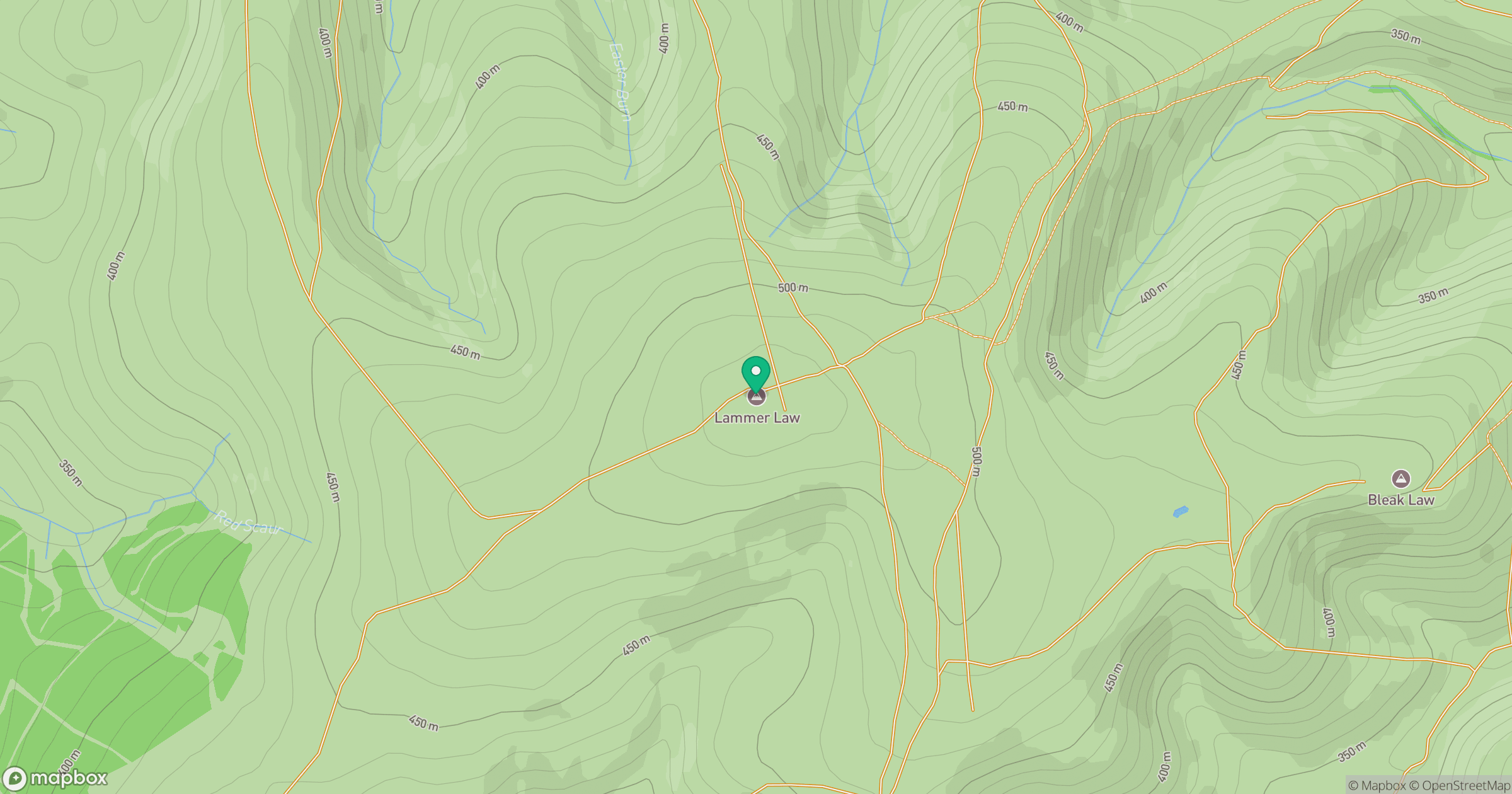
Grid reference: NT523618
View on OpenStreetMapOpens a map in a new tab, centred on the hill.
No comments yet. Be the first.