
Garn Fawr
Good walks are even better shared.
Overview
Garn Fawr, Pembrokeshire
Garn Fawr rises above Pwll Deri on the Pencaer peninsula near Goodwick and Fishguard. The current primary record gives 213 m height and 142 m prominence, classified as a Hump and Tump. Its former Submarilyn classification was removed in May 2025 following a list-definition change. Hill record
Summit and landscape
The exact high point is a rock 3 m northwest of the trig point, at SM 89586 38877. The trig is a useful landmark rather than the precise natural summit.
Pembrokeshire Coast National Park describes Garn Fawr as a resistant igneous intrusion. Its rocky top overlooks the coast, Strumble Head lighthouse and the Pencaer peninsula. Iron Age walls link the natural outcrops; a wartime lookout survives nearby. Landscape and history
Complete return walks
- Garn Fawr viewpoint circuit, 1.6 km: from the eastern car park at SM8989438830, climb to the summit area, descend past the lookout and return around the hillside. The route includes steep paths, stiles and a short rock scramble. National Trust route
- Strumble Head and Garn Fawr circular, 8.1 km: from the same eastern car-park area, take lanes via Caerlem to Strumble Head, return south along the coast path, then climb Garn Fawr and descend to the start. This is Walking Britain’s complete loop; use its map and junction directions. Full route
Keep clear of cliff edges and protect the archaeological remains. Wet and windy weather can make the rocky climb much harder. Dogs should be on leads around the grazing livestock. The car park and short trail have no facilities.
Getting here
Fishguard & Goodwick is the rail gateway, with additional onward travel required. The published 404 summer shuttle timetable ended on 27 September 2026. Check the council’s latest transport information rather than assuming it runs in autumn. Dated timetable
Sources checked 18 October 2026. Route lengths describe the specific complete circuits above, not a one-way ascent; no personal on-foot inspection is claimed.
Explore routes near Garn Fawr
Public walks starting within 80 km of this hill. Nearby does not mean a route reaches the summit; check its map and access before setting out.
Pembrokeshire Coast Path: Newport Parrog to Fishguard via Dinas Head
View route
Neyland to Johnston: Brunel and Westfield Railway Trail
View route
Stackpole Estate: Bosherston Lily Ponds and Lodge Park Woodland Circuit
View route
Abergwili to Nantgaredig: Tywi Valley Path out and back
View route
Route planning notes
These notes describe possible approaches, not verified navigable routes or permission to cross land. Check current paths, local access rules and conditions before setting out.
Garn Fawr viewpoint circuit
Start and finish at Garn Fawr car park (SM8989438830). Climb the path opposite the entrance, keep right at the junction, then pass through the wall gap and scramble over rock to the summit area. Descend by the wartime lookout steps, follow the steep path towards Pwll Deri and turn left around the hillside. Cross two stiles and stone steps; stay above the wall at the third stile and continue behind the cottage to the car park. National Trust’s 1.6 km total is for this complete circuit. The precise high point is the rock just northwest of the trig. Source: https://www.nationaltrust.org.uk/visit/wales/garn-fawr-to-poppit-sands/garn-fawr-viewpoint-walk
Strumble Head and Garn Fawr circular
Start and finish at the eastern Garn Fawr car park (SM899388). Walk down the lane past Caerlem, turn left at SM903399 and continue to Strumble Head. Join the coast path near SM895412 and follow it south to the lane at SM893388. Cross to the waymarked left-hand driveway and climb past the crag to Garn Fawr; descend beside the wall to the starting car park. Walking Britain’s 8.1 km total covers this complete return circuit, including the summit ascent. Use its full directions and map; exposed cliffs and road sections need care. Source: https://www.walkingbritain.co.uk/walk-3480-description
Make a day of it, together
Find someone to share the walk with, or organise a day out along a route you like.
Hill facts and local notes
Classifications
Elevation
213m
699 ft
Prominence
142m
Coordinates
52.0083, -5.0673
SM895388
OS Map
157
Explorer: OL35W
At the Summit
The 213 m natural high point is a rock 3 m northwest of the trig point at SM 89586 38877. The trig, Iron Age ramparts and nearby wartime lookout are separate features.
Terrain & Geology
Garn Fawr is a resistant igneous intrusion in the volcanic landscape of north Pembrokeshire. Pembrokeshire Coast National Park explains that magma cooled below ground here, leaving rocky crags as softer surrounding material eroded. The specific rhyolitic-tuff claim is not established for this summit.
Views & Scenery
Views across the north Pembrokeshire coast, Strumble Head lighthouse and the Pencaer peninsula, subject to visibility.
History & Heritage
Historical Significance
Garn Fawr has a substantial Iron Age stone-built hillfort. National Trust’s trail and the National Park identify the surviving lookout as First World War. Coflein records an early archaeological survey by Edward Lhuyd around 1700.
Getting There & Facilities
Check current local access restrictions, parking rules and transport timetables before travelling. These notes do not confirm public access to the summit.
Parking
Garn Fawr car park east of the hill, SM8989438830, is the National Trust viewpoint route’s start and finish. Space is limited; park considerately and follow current signs.
Public Transport
Fishguard & Goodwick is the local rail gateway; onward travel to the hill is additional. The council’s published 404 Strumble Shuttle summer timetable ran from 23 May to 27 September 2026. As checked on 18 October 2026, that timetable is out of season and cannot be relied on for an October bus. Check current Pembrokeshire County Council journey information before travelling.
Nearby Facilities
National Trust lists no facilities on the viewpoint trail. Carry water and check services in Goodwick or Fishguard before setting out.
Safety Information
Known Hazards
- The viewpoint route includes a short rock scramble and steep uneven descent; wet rock, mud and strong winds increase the difficulty.
- Keep away from cliff edges on longer coastal walks and supervise children closely.
- Cattle and ponies graze here; National Trust asks that dogs stay on leads.
- Follow marked paths, protect hillfort remains, and take care on the lanes.
General Safety Tips
- Check weather conditions before setting out
- Carry appropriate clothing and equipment
- Let someone know your planned route
- Take a map, compass, and GPS device
- Carry emergency supplies: food, water, first aid kit, torch
Hills
Some common questions about the hills answered
Are there group walks up Garn Fawr?
Many walkers use Walkmates to join or organise walks with others. You can check for group walks around Garn Fawr through the maps
Are there other walkers around Garn Fawr?
Activity varies by location and time, but Walkmates lets you see whether others have shared walks or shown interest in this area. Find other people through the walking friends search walking friends for Garn Fawr search or of course create your own walk for Garn Fawr
Can I organise a walk to Garn Fawr?
Yes. If there aren’t any walks listed already, you can create a walk and make it available for others to join.
If you're signed up to Walkmates, you can create a walk to Garn Fawr.
How do I find a walk up this hill?
There are often multiple ways to walk this hill, depending on experience and route preference. Walkmates helps you explore walks and routes that others have shared.
Can I suggest a new route up Garn Fawr?
Yes. You can suggest or create routes to share with others. Walkmates focuses on the social side of walking, so routes are used to help people organise walks and explore areas together, rather than as detailed navigation tools or route libraries.
Other uses really appreciate knowledgeable walkers sharing their routes. Share your favourite route to Garn Fawr here
The is an error or something incorrect about this hill. How do I let you know?
We always strive to keep the information on Walkmates as accurate as possible. If you find an error, please let us know through the contact form and we'll aim to correct it as quickly as possible
Community Discussion
Comments
Location
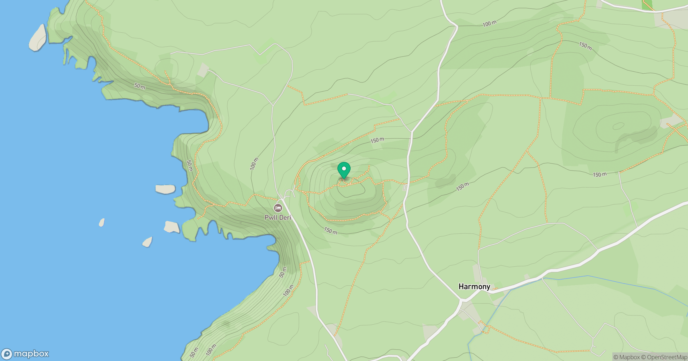
Grid reference: SM895388
View on OpenStreetMapOpens a map in a new tab, centred on the hill.
Hills within 30 km
Straight-line distance, not a walking route or confirmation of access.
No comments yet. Be the first.