

Carn Llidi
Good walks are even better shared.
SM7327 : Carn Llidi
Colin Smith Photo source
Overview
Carn Llidi is a 181 m rocky hill above Whitesands Bay on the St Davids peninsula, within Pembrokeshire Coast National Park. The summit is reached by a short rock scramble and looks over the coast and Ramsey Island. Walkers can also use the lower viewpoint or explore St David’s Head on coastal paths. Prehistoric monuments and wartime remains add interest to the surrounding landscape.
Carn Llidi
Carn Llidi is a 181 m rocky hill above Whitesands Bay on the St Davids peninsula, within Pembrokeshire Coast National Park. The summit is reached by a short rock scramble and looks over the coast and Ramsey Island. Walkers can also use the lower viewpoint or explore St David’s Head on coastal paths. Prehistoric monuments and wartime remains add interest to the surrounding landscape.
Height: 181 m (594 ft). Prominence: 122 m. Classification: Hump (source codes Hu,1).
Summit
A rock with protruding bolts marks the highest point at SM 73806 28007. Reaching it requires a short scramble above the easier viewpoint approach.
Geology
Carn Llidi forms part of the Ordovician St David’s Head Intrusion. Its crags expose layered gabbro and related igneous rocks, formed as magma cooled beneath the surface. The intrusion and surrounding sedimentary rocks were later folded during the Caledonian mountain-building period.
Routes
Carn Llidi summit from Whitesands via Upper Porthmawr
Start at Whitesands car park (SM734272). Walk back up the B4583, pass the first track on the left and take the next left by the caravan site. Follow the signed track through Upper Porthmawr and take the right-hand branch at the National Trust St David’s Head sign. Continue uphill past the metal posts. Where the concrete path turns right up steps, bear left towards the rocky summit; the final section requires a short scramble. Descend carefully by the same route and return through the farm to Whitesands. Keep dogs on leads at the farm. The lower viewpoint is an alternative if the summit rocks are unsuitable.
Difficulty: Moderate approach; summit scramble.
Carn Llidi viewpoint from Whitesands, out and back
The National Park’s short walk starts at Whitesands car park (SM734272). Walk up the road, take the left turn beyond the caravan site and follow the signed track through Upper Porthmawr. Take the right-hand branch at the National Trust sign, then the narrower path beyond the metal posts to the viewpoint. Return along the same track and road to Whitesands. There are stiles and steps; keep dogs on leads through the farm. The 2.3 km covers this complete viewpoint return, excluding the separate rocky scramble to Carn Llidi’s summit.
Difficulty: Moderate; uneven track, stiles and steps. Distance: 2.3 km.
St David’s Head coastal loop from Whitesands
Follow the National Trust’s coastal circuit from Whitesands car park (SM734272) to Porth Melgan. Cross the bridge and follow the valley north-east, then rejoin the coast and turn left towards St David’s Head. Continue past Coetan Arthur and the headland fort, return along the coast to Porth Melgan and retrace the path to Whitesands. The published 6 km and 1 hour 15 minutes describe this whole coastal loop. It does not visit Carn Llidi’s summit; adding the summit requires a separate scramble and additional walking. Expect rocky paths, steps, cliff edges and muddy valley ground.
Difficulty: Moderate coastal walk. Distance: 6 km. Time: 1 hour 15 minutes.
Views
Views include Whitesands Bay, St David’s Head, Ramsey Island and the offshore Bishops and Clerks rocks. The lower viewpoint also gives wide coastal views. Heather and gorse colour the St David’s Head coastal heath purple and gold in late summer.
Terrain
Farm tracks, uneven coastal paths, steps and stiles, rocky summit requiring a short scramble, muddy valley ground in wet conditions
Hazards
The final summit rocks require a short scramble and confident footing. Take particular care descending; use the lower viewpoint if the rocks or conditions are unsuitable.
Coastal routes pass cliff edges. Keep to marked paths, stay back from the edges and supervise children and dogs.
Rough, uneven paths, steps and stiles require care. Wet rock and strong winds make the exposed coastal setting more hazardous.
Keep dogs on leads around grazing livestock and through Upper Porthmawr, where there are free-range chickens.
The valley above Porth Melgan can be muddy and slippery in winter. Avoid the summit scramble in wet or windy conditions. If visiting the beach with a dog, Whitesands has a beach ban from 1 May to 30 September, with leads required on the promenade and in the car park during those dates. Check the National Park’s Trail News and follow local diversion signs before setting out.
Access and facilities
Whitesands car park at the end of the B4583, grid reference SM734272, is the start for these walks. It is operated by St Davids City Council. The published 2026 car tariff is £6.50 for the day or £4 after 3 pm. Charging applies from 1 March to 31 October; November to February is free. Check the signs for current terms.
The 403 Celtic Coaster links St Davids with Whitesands in summer. Its published 2026 season ran from 28 March to 27 September; it is not a winter service. Check Pembrokeshire County Council’s current timetable before planning a bus-dependent walk.
Whitesands has public toilets and a beach cafe beside the car park. Check opening hours before relying on refreshments, especially outside the main season. St Davids has further shops and places to eat.
Nearby summits and features
Carn Porth-llong (75.7 m), Carn Treliwyd (141.7 m) and Penberry (175 m).
Whitesands Bay, Porth Melgan, St David’s Head and Coetan Arthur burial chamber. Carn Llidi’s slopes and the neighbouring headland contain prehistoric field boundaries, burial chambers and remains of wartime installations.
History
Carn Llidi and St David’s Head contain Neolithic burial chambers and an extensive prehistoric field system, with an Iron Age fort on the headland. Second World War radar remains survive near Carn Llidi; the area had also been used for a First World War hydrophone station. These documented sites form part of the peninsula’s archaeological landscape.
Explore routes near Carn Llidi
Walks starting near this hill. Open a route to check its map, distance and full itinerary.
Neyland to Johnston: Brunel and Westfield Railway Trail
View route
Stackpole Estate: Bosherston Lily Ponds and Lodge Park Woodland Circuit
View route
Abergwili to Nantgaredig: Tywi Valley Path out and back
View route
Gower winter wildlife and birdwatching walk
View route
Route planning notes
These notes describe possible approaches. Check a route's map and access information when planning your walk.
Carn Llidi summit from Whitesands via Upper Porthmawr
Start at Whitesands car park (SM734272). Walk back up the B4583, pass the first track on the left and take the next left by the caravan site. Follow the signed track through Upper Porthmawr and take the right-hand branch at the National Trust St David’s Head sign. Continue uphill past the metal posts. Where the concrete path turns right up steps, bear left towards the rocky summit; the final section requires a short scramble. Descend carefully by the same route and return through the farm to Whitesands. Keep dogs on leads at the farm. The lower viewpoint is an alternative if the summit rocks are unsuitable.
Carn Llidi viewpoint from Whitesands, out and back
The National Park’s short walk starts at Whitesands car park (SM734272). Walk up the road, take the left turn beyond the caravan site and follow the signed track through Upper Porthmawr. Take the right-hand branch at the National Trust sign, then the narrower path beyond the metal posts to the viewpoint. Return along the same track and road to Whitesands. There are stiles and steps; keep dogs on leads through the farm. The 2.3 km covers this complete viewpoint return, excluding the separate rocky scramble to Carn Llidi’s summit.
St David’s Head coastal loop from Whitesands
Follow the National Trust’s coastal circuit from Whitesands car park (SM734272) to Porth Melgan. Cross the bridge and follow the valley north-east, then rejoin the coast and turn left towards St David’s Head. Continue past Coetan Arthur and the headland fort, return along the coast to Porth Melgan and retrace the path to Whitesands. The published 6 km and 1 hour 15 minutes describe this whole coastal loop. It does not visit Carn Llidi’s summit; adding the summit requires a separate scramble and additional walking. Expect rocky paths, steps, cliff edges and muddy valley ground.
Make a day of it, together
Find someone to share the walk with, or organise a day out along a route you like.
Photo Gallery
View all Photo could not load
SM7327 : Carn Llidi
Colin Smith
 Photo could not load
SM7327 : Bluebells beside a footpath below Carn Llidi in May
Jeremy Bolwell
 Photo could not load
SM7327 : Carn Llidi
Alan Hughes
 Photo could not load
SM7328 : The view northeast from the summit of Carn Llidi
Andy F
 Photo could not load
SM7328 : Concrete steps near the summit of Carn Llidi
Andy F
 Photo could not load
SM7328 : Defence site foundations near the summit of Carn Llidi
Andy F
 Photo could not load
SM7328 : On the slopes of Carn Llidi
John Duckfield
 Photo could not load
SM7328 : The view east from the summit of Carn Llidi
Andy F
 Photo could not load
SM7328 : Concrete path near summit of Carn Llidi
Andy F

SM7327 : View southwards from Carn Llidi, Pembs
Jeremy Bolwell
Hill facts and local notes
Classifications
Elevation
181m
594 ft
Prominence
122m
Coordinates
51.9045, -5.2897
SM738280
OS Map
157
Explorer: OL35W
At the Summit
A rock with protruding bolts marks the highest point at SM 73806 28007. Reaching it requires a short scramble above the easier viewpoint approach.
Terrain & Geology
Carn Llidi forms part of the Ordovician St David’s Head Intrusion. Its crags expose layered gabbro and related igneous rocks, formed as magma cooled beneath the surface. The intrusion and surrounding sedimentary rocks were later folded during the Caledonian mountain-building period.
Views & Scenery
Views include Whitesands Bay, St David’s Head, Ramsey Island and the offshore Bishops and Clerks rocks. The lower viewpoint also gives wide coastal views.
Best Seasons
Heather and gorse colour the St David’s Head coastal heath purple and gold in late summer.
History & Heritage
Historical Significance
Carn Llidi and St David’s Head contain Neolithic burial chambers and an extensive prehistoric field system, with an Iron Age fort on the headland. Second World War radar remains survive near Carn Llidi; the area had also been used for a First World War hydrophone station. These documented sites form part of the peninsula’s archaeological landscape.
Getting There & Facilities
Parking
Whitesands car park at the end of the B4583, grid reference SM734272, is the start for these walks. It is operated by St Davids City Council. The published 2026 car tariff is £6.50 for the day or £4 after 3 pm. Charging applies from 1 March to 31 October; November to February is free. Check the signs for current terms.
Public Transport
The 403 Celtic Coaster links St Davids with Whitesands in summer. Its published 2026 season ran from 28 March to 27 September; it is not a winter service. Check Pembrokeshire County Council’s current timetable before planning a bus-dependent walk.
Nearby Facilities
Whitesands has public toilets and a beach cafe beside the car park. Check opening hours before relying on refreshments, especially outside the main season. St Davids has further shops and places to eat.
Safety Information
Known Hazards
- The final summit rocks require a short scramble and confident footing. Take particular care descending; use the lower viewpoint if the rocks or conditions are unsuitable.
- Coastal routes pass cliff edges. Keep to marked paths, stay back from the edges and supervise children and dogs.
- Rough, uneven paths, steps and stiles require care. Wet rock and strong winds make the exposed coastal setting more hazardous.
- Keep dogs on leads around grazing livestock and through Upper Porthmawr, where there are free-range chickens.
Seasonal Hazards
The valley above Porth Melgan can be muddy and slippery in winter. Avoid the summit scramble in wet or windy conditions. If visiting the beach with a dog, Whitesands has a beach ban from 1 May to 30 September, with leads required on the promenade and in the car park during those dates. Check the National Park’s Trail News and follow local diversion signs before setting out.
General Safety Tips
- Check weather conditions before setting out
- Carry appropriate clothing and equipment
- Let someone know your planned route
- Take a map, compass, and GPS device
- Carry emergency supplies: food, water, first aid kit, torch
Hills
Some common questions about the hills answered
Are there group walks up Carn Llidi?
Many walkers use Walkmates to join or organise walks with others. You can check for group walks around Carn Llidi through the maps
Are there other walkers around Carn Llidi?
Activity varies by location and time, but Walkmates lets you see whether others have shared walks or shown interest in this area. Find other people through the walking friends search walking friends for Carn Llidi search or of course create your own walk for Carn Llidi
Can I organise a walk to Carn Llidi?
Yes. If there aren’t any walks listed already, you can create a walk and make it available for others to join.
If you're signed up to Walkmates, you can create a walk to Carn Llidi.
How do I find a walk up this hill?
There are often multiple ways to walk this hill, depending on experience and route preference. Walkmates helps you explore walks and routes that others have shared.
Can I suggest a new route up Carn Llidi?
Yes. You can suggest or create routes to share with others. Walkmates focuses on the social side of walking, so routes are used to help people organise walks and explore areas together, rather than as detailed navigation tools or route libraries.
Other uses really appreciate knowledgeable walkers sharing their routes. Share your favourite route to Carn Llidi here
The is an error or something incorrect about this hill. How do I let you know?
We always strive to keep the information on Walkmates as accurate as possible. If you find an error, please let us know through the contact form and we'll aim to correct it as quickly as possible
Community Discussion
Comments
Location
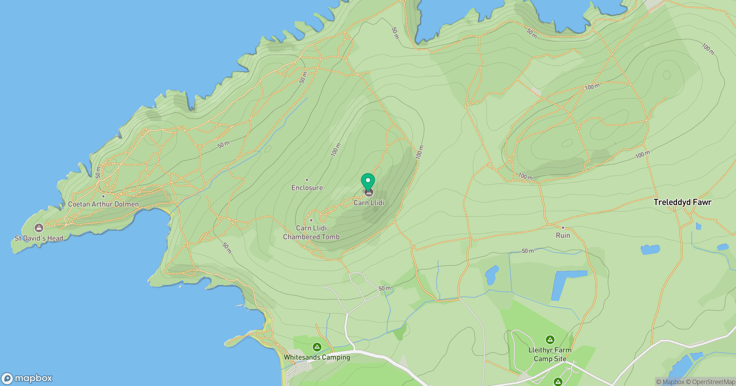
Grid reference: SM738280
View on OpenStreetMapOpens a map in a new tab, centred on the hill.
No comments yet. Be the first.