

Culvennan Fell
Good walks are even better shared.
Overview
Culvennan Fell
Culvennan Fell, rising to an elevation of 390 meters, is a lovely little Marilyn located in the Southern Uplands of Scotland. It's a popular spot for those looking to enjoy a bite of nature without having to tackle the likes of Ben Nevis!
Geology
This fell is predominantly composed of schist and granite. These ancient rocks share stories of the Earth's dynamic history, showcasing fascinating mineral formations and a rugged terrain. Keep your eyes peeled for interesting rock formations as you hike!
Routes
The Culvennan Circular Route is a 7.5 km trek that takes approximately 2.5 hours to complete. It's considered moderate, making it suitable for most hikers. Just remember to pack some refreshments for a lovely picnic at the summit!
Summit Features
At the top, the path leads you to a small cairn that marks the summit—ideal for a post-hike selfie! After all, if you didn’t post it on social media, did you even climb it?
Terrain Type
Expect a mix of grassy paths with rocky outcrops interspersed. This varied terrain offers a little bit of everything—just be prepared for the occasional squishy spot!
Views
The summit boasts stunning views of the Southern Uplands, and on a good day, you might even catch a glimpse of the Solway Firth. Spring and early summer bring the best views, as the landscape bursts into life with vibrant colours.
Hazards
While the path is mostly manageable, some rocky areas can become slippery when wet—so tread carefully! It's wise to keep an eye on the weather to avoid any surprises.
Nearby Summits
If you're feeling adventurous, consider including nearby summits such as Kirkconnell Fell (439 m) and Castle Hill (320 m) in your itinerary.
Access
For parking, there’s a handy little gravel area along the B7076, where you can leave your car. The nearest bus service can be found in Dumfries, with a short bus ride to Cummertrees and then a walk to the fell.
Facilities
Dumfries has all you need in terms of cafés and public amenities, but be aware that there are no facilities on the hill itself.
History
The name 'Culvennan' evokes an image of a quaint little nook, fitting for a fell of this nature with its gentle slopes and welcoming atmosphere. The area has a rich agricultural backdrop, serving as pastureland for locals for centuries.
In conclusion, Culvennan Fell may not be the highest peak in Scotland, but it's certainly a gem worth exploring! Grab your walking boots, a map, and perhaps a good sense of humour, and head on out for an adventure. You won't regret it!
Explore routes near Culvennan Fell
Public walks starting within 80 km of this hill. Nearby does not mean a route reaches the summit; check its map and access before setting out.
Wood of Cree Waterfalls and Scrubland Circuit
View route
Knockman Wood Cairn and Woodland Trail
View route
Kirroughtree Little Bruntis Lochs and Woodland Trail
View route
Glentrool Water of Trool and Spout Head Trail
View route
Route planning notes
These notes describe possible approaches, not verified navigable routes or permission to cross land. Check current paths, local access rules and conditions before setting out.
Culvennan Circular Route
A delightful circular walk that encompasses the best of Culvennan Fell, featuring picturesque views and varied terrain.
Make a day of it, together
Find someone to share the walk with, or organise a day out along a route you like.
Photo Gallery
View all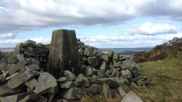 Photo could not load
NX3165 : Culvennan Fell trig
Colin Kinnear
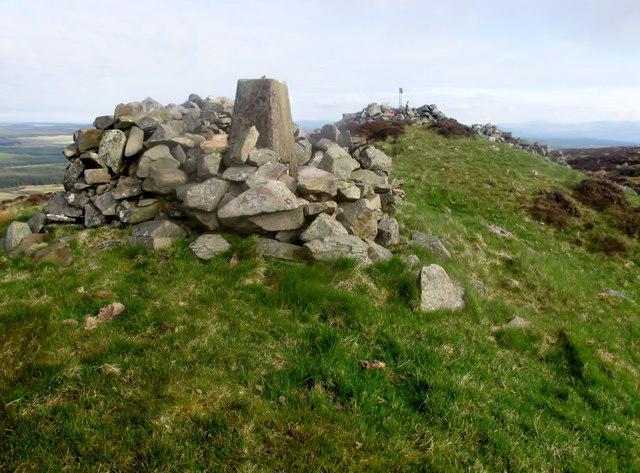 Photo could not load
NX3165 : Culvennan Fell
Rude Health
Hill facts and local notes
Classifications
Elevation
215m
705 ft
Prominence
111m
Coordinates
54.9512, -4.6395
NX310650
OS Map
82
Explorer: 310
At the Summit
The summit is adorned with a small cairn and offers a panoramic view of the surrounding countryside, making it an ideal spot for a cuppa or a cheeky snack.
Terrain & Geology
Culvennan Fell is primarily composed of schist and granite, with striking outcroppings that add an interesting dynamic to the landscape. The rocks tell a tale of ancient geological processes that shaped this part of the Southern Uplands.
Views & Scenery
On a clear day, you can see the rolling hills of the Southern Uplands, as well as a glimpse of the Solway Firth in the distance.
History & Heritage
Name Origin
Culvennan is believed to derive from 'Cul' meaning 'nook' and a variant of 'vennan' which means 'little hill', aptly describing its geographical character.
Historical Significance
Historically, the area served as pastureland for local farms and has a rich agricultural heritage.
Getting There & Facilities
Check current local access restrictions, parking rules and transport timetables before travelling. These notes do not confirm public access to the summit.
Parking
There is a small gravel pull-in along the B7076 near the foot of the fell, suitable for a few cars.
Public Transport
The nearest bus stop is in the village of Cummertrees, with occasional services from Dumfries.
Nearby Facilities
Dumfries has several cafés and public toilets. However, there are no facilities directly at the foot of Culvennan Fell.
Safety Information
Known Hazards
- The terrain can be slippery in wet conditions, especially around rocky outcrops. Take care and watch your step!
General Safety Tips
- Check weather conditions before setting out
- Carry appropriate clothing and equipment
- Let someone know your planned route
- Take a map, compass, and GPS device
- Carry emergency supplies: food, water, first aid kit, torch
Hills
Some common questions about the hills answered
Are there group walks up Culvennan Fell?
Many walkers use Walkmates to join or organise walks with others. You can check for group walks around Culvennan Fell through the maps
Are there other walkers around Culvennan Fell?
Activity varies by location and time, but Walkmates lets you see whether others have shared walks or shown interest in this area. Find other people through the walking friends search walking friends for Culvennan Fell search or of course create your own walk for Culvennan Fell
Can I organise a walk to Culvennan Fell?
Yes. If there aren’t any walks listed already, you can create a walk and make it available for others to join.
If you're signed up to Walkmates, you can create a walk to Culvennan Fell.
How do I find a walk up this hill?
There are often multiple ways to walk this hill, depending on experience and route preference. Walkmates helps you explore walks and routes that others have shared.
Can I suggest a new route up Culvennan Fell?
Yes. You can suggest or create routes to share with others. Walkmates focuses on the social side of walking, so routes are used to help people organise walks and explore areas together, rather than as detailed navigation tools or route libraries.
Other uses really appreciate knowledgeable walkers sharing their routes. Share your favourite route to Culvennan Fell here
The is an error or something incorrect about this hill. How do I let you know?
We always strive to keep the information on Walkmates as accurate as possible. If you find an error, please let us know through the contact form and we'll aim to correct it as quickly as possible
Community Discussion
Comments
Location
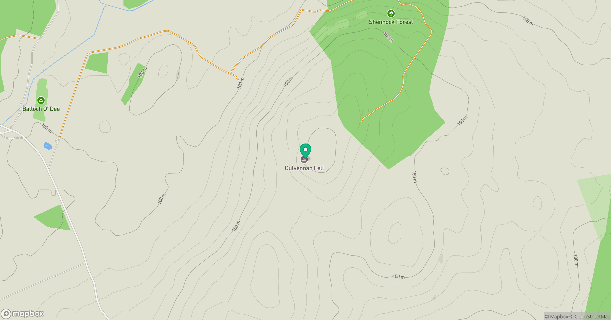
Grid reference: NX310650
View on OpenStreetMapOpens a map in a new tab, centred on the hill.
Hills within 30 km
Straight-line distance, not a walking route or confirmation of access.
No comments yet. Be the first.