

Barr Thormaid
Good walks are even better shared.
Overview
Barr Thormaid: A Highland Gem
Nestled within the stunning expanse of the Scottish Highlands, Barr Thormaid is one of those unassuming mountains that captures the heart of every hiker. Standing at 308 meters, it may not be the tallest peak among its neighbours, but what it lacks in height, it more than compensates with breathtaking scenery and a sense of adventure.
Geology
Barr Thormaid is made up predominantly of metamorphic schist, a rock form that has seen countless geological transformations. Geology enthusiasts will find the landscape intriguing, with rock formations that tell the story of ages gone by. Make sure to take a moment to appreciate the ancient stones that have witnessed the passage of time!
Routes
The Torridon Trail is the most popular route to the summit. This moderate hike spans approximately 10.5 km and typically takes about 4.5 hours to complete, offering a wonderful mix of terrain that includes rocky outcrops and grassy slopes—don’t forget to keep an eye out for those boggy patches; they may invite you to an unexpected splash!
Summit Features
As you reach the summit, you'll be greeted by a sturdy cairn, providing not just a magnificent photo opportunity, but also a reassuring sign that you've made it to the top! So, strike a pose and celebrate your triumph over the Highland heights.
Terrain
The terrain on your journey can be quite mixed, merging rocky sections and grassy meadows. Just remember to be careful as you navigate this beautiful landscape, as it’s all too easy to trip over a wayward stone, especially if you're busy admiring the views!
Views
And oh, the views! From the top, the panorama stretches out before you, showcasing Loch Gairloch and the islands that punctuate the horizon. The best time to experience these vistas is during spring and early summer when the heather is blooming in vibrant purple hues.
Hazards
While hiking Barr Thormaid is manageable, be cautious of the uneven terrain, which can lead to trips and falls. Moreover, weather in the Highlands can change as quickly as a squirrel can scamper up a tree, so ensure you're prepared for all elements, even if it is sunny when you set off!
Nearby Summits
If you're feeling ambitious, nearby summits such as Ben Ryvington (324 m) and the more formidable An Teallach (1064 m) await your adventurous spirit, making for a climber’s perfect playground.
Access
The nearest parking can be found in the lovely village of Gairloch, about 1.5 km from the trailhead. Public transport can get you there via local buses from Inverness, though services can be a bit hit or miss. Gairloch itself is a delightful spot with cafes and facilities to stock up on snacks.
Facilities
Before or after your hike, don’t miss out on the cafes in Gairloch, which serve hearty meals and hot drinks to reward your hard work on the trails!
History
The name Barr Thormaid, translating to 'Hill of the Great Place' in Gaelic, hints at its importance to past inhabitants. Remnants of ancient settlements nearby remind us that this mountain has been a witness to many stories.
Now get out there and enjoy everything Barr Thormaid has to offer!
Happy hiking!
Explore routes near Barr Thormaid
Public walks starting within 80 km of this hill. Nearby does not mean a route reaches the summit; check its map and access before setting out.
Crinan Canal: Bellanoch and Dunardry towpath return
View route
Glen Kin group walk
View route
Bishop’s Glen group walk
View route
West Bay walk and talk
View route
Route planning notes
These notes describe possible approaches, not verified navigable routes or permission to cross land. Check current paths, local access rules and conditions before setting out.
Torridon Trail
A scenic route starting from the village of Gairloch, winding through breathtaking landscapes and leading up to Barr Thormaid.
Make a day of it, together
Find someone to share the walk with, or organise a day out along a route you like.
Photo Gallery
View all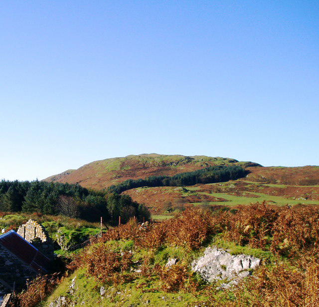 Photo could not load
NR7183 : Barr Thormaid seen from Kilmory Ross
Chris Purslow
Hill facts and local notes
Classifications
Elevation
130m
427 ft
Prominence
117m
Coordinates
55.9874, -5.6717
NR710832
OS Map
55
Explorer: 355N 358S
At the Summit
The summit features a prominent cairn, offering a perfect spot for those all-important selfies with your best hiking mates.
Terrain & Geology
The mountain primarily consists of metamorphic rocks, with interesting schist formations that tell the tale of ancient geological events. The rugged landscape is both beautiful and fascinating for geology enthusiasts.
Views & Scenery
From the summit, you can see the stunning views of the surrounding Highlands, including Loch Gairloch and the islands dotting the horizon.
History & Heritage
Name Origin
The name Barr Thormaid is thought to mean 'Hill of the Great Place' in Gaelic, reflecting its impressive stature in the local landscape.
Historical Significance
Historically, this mountain was significant for local clans; remnants of ancient settlements can sometimes be spotted in the valley below.
Getting There & Facilities
Check current local access restrictions, parking rules and transport timetables before travelling. These notes do not confirm public access to the summit.
Parking
There is a small parking area in Gairloch, which is approximately 1.5 km from the starting point of the trail.
Public Transport
Gairloch is accessible by local buses from Inverness; check the schedule as services may be sparse.
Nearby Facilities
In Gairloch, you'll find cafes, a few small shops, and public toilets to prepare you for your hike.
Safety Information
Known Hazards
- Uneven terrain can pose a risk of trips and falls; be mindful of where you step. Weather can change rapidly in the Highlands, so prepare for all conditions.
General Safety Tips
- Check weather conditions before setting out
- Carry appropriate clothing and equipment
- Let someone know your planned route
- Take a map, compass, and GPS device
- Carry emergency supplies: food, water, first aid kit, torch
Hills
Some common questions about the hills answered
Are there group walks up Barr Thormaid?
Many walkers use Walkmates to join or organise walks with others. You can check for group walks around Barr Thormaid through the maps
Are there other walkers around Barr Thormaid?
Activity varies by location and time, but Walkmates lets you see whether others have shared walks or shown interest in this area. Find other people through the walking friends search walking friends for Barr Thormaid search or of course create your own walk for Barr Thormaid
Can I organise a walk to Barr Thormaid?
Yes. If there aren’t any walks listed already, you can create a walk and make it available for others to join.
If you're signed up to Walkmates, you can create a walk to Barr Thormaid.
How do I find a walk up this hill?
There are often multiple ways to walk this hill, depending on experience and route preference. Walkmates helps you explore walks and routes that others have shared.
Can I suggest a new route up Barr Thormaid?
Yes. You can suggest or create routes to share with others. Walkmates focuses on the social side of walking, so routes are used to help people organise walks and explore areas together, rather than as detailed navigation tools or route libraries.
Other uses really appreciate knowledgeable walkers sharing their routes. Share your favourite route to Barr Thormaid here
The is an error or something incorrect about this hill. How do I let you know?
We always strive to keep the information on Walkmates as accurate as possible. If you find an error, please let us know through the contact form and we'll aim to correct it as quickly as possible
Community Discussion
Comments
Location
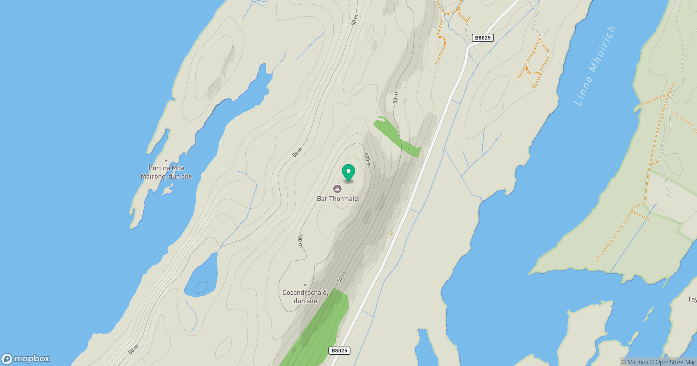
Grid reference: NR710832
View on OpenStreetMapOpens a map in a new tab, centred on the hill.
Hills within 30 km
Straight-line distance, not a walking route or confirmation of access.
Beinn an Oir
785m
Cnoc Reamhar
266m
Cruach Lusach
467m
Cruach Ionnastail
295m
Beinn Sgaillinish
194m
No comments yet. Be the first.