

Cruach Lusach
Good walks are even better shared.
NR7883 : Cruach Lusach from the top looking North
Alan Davidson Photo source
Overview
Cruach Lusach
Overview
Cruach Lusach is a delightful Marilyn located in the Scottish Highlands, known for its approachable slopes and stunning vistas. Standing at 600 meters, this mountain is perfect for both novice hikers looking for a manageable challenge and seasoned walkers wanting to stretch their legs.
Geology
The geology of Cruach Lusach is primarily characterised by metamorphic rocks like schists and gneisses. This fascinating geology not only shapes the mountain's appearance but also influences the flora and fauna that inhabit the area. As you climb, take a moment to appreciate the unique rock formations and the vibrant wildlife.
Routes
The most popular route is the Southern Approach from Lussa Lodge. This moderate trek spans about 4.5 km and takes approximately 2.5 hours to complete. The path meanders through beautiful landscapes dotted with wildflowers and heather, offering glimpses of the breathtaking views that await at the summit. Don't forget your camera, as the snap-worthy moments are endless!
Summit Features
Upon reaching the summit of Cruach Lusach, you'll be greeted by a charming cairn. It's a perfect place to catch your breath, enjoy a snack or have a quick chat with fellow enthusiasts. Just be warned, the local sheep seem to think they own the place!
Terrain
The terrain consists mainly of grassy slopes combined with rocky outcrops, interspersed with the occasional boggy patch. Suitable footwear is essential unless you want to experience an unplanned sock dunking. Waterproof boots are highly recommended, especially after a bit of rain.
Views
The summit rewards hikers with glorious panoramic views. Loch Sween sparkles in the distance, surrounded by lush green hills, while the Paps of Jura can sometimes be spotted looming in the horizon on clear days. For the best experience, consider hiking in spring or early autumn when the visibility is magnificent.
Hazards
As beautiful as the mountain is, it does have its challenges—be mindful of changing weather conditions, which can be as unpredictable as a cat on a hot tin roof! Slippery rocks and hidden bogs can also pose risks, so a careful approach is warranted.
Access
Nearest Parking
Parking is available at Lussa Lodge. Spaces are limited, so plan ahead to avoid disappointment.
Public Transport
Public transport is somewhat sparse; the nearest bus service to Tarbert runs infrequently. A car is highly recommended to get close to the trailhead.
Nearest Town
Tarbert, approximately 15 miles to the east, is the closest hub where you can find essential amenities.
Facilities
While the summit lacks any facilities, Tarbert is home to delightful cafes and shops where you can replenish your energy levels post-hike. Remember to hydrate and fuel yourself before setting off!
History
The name 'Cruach Lusach' translates from Gaelic as 'hill of the sweet heather', reflecting the vibrant flora that adorns its slopes. Moreover, the mountain boasts a rich history, being part of local folklore and serving as a natural landmark for generations of visitors.
In conclusion, Cruach Lusach is a gem in the Scottish Highlands that offers both a rewarding challenge and memorable views. Grab your gear, lace up your boots, and embark on an adventure to this welcoming peak!
Explore routes near Cruach Lusach
Walks starting near this hill. Open a route to check its map, distance and full itinerary.
Crinan Canal: Bellanoch and Dunardry towpath return
View route
Glen Kin group walk
View route
Bishop’s Glen group walk
View route
West Bay morning walk and silent disco
View route
Route planning notes
These notes describe possible approaches. Check a route's map and access information when planning your walk.
Southern Approach from Lussa Lodge
A scenic and straightforward route leading from Lussa Lodge, offering beautiful views as you ascend through heather-covered slopes.
Make a day of it, together
Find someone to share the walk with, or organise a day out along a route you like.
Photo Gallery
View all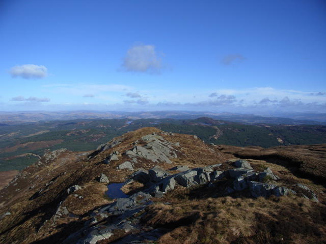 Photo could not load
NR7883 : Cruach Lusach from the top looking North
Alan Davidson
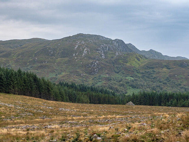 Photo could not load
NR7883 : Cruach Lusach from the north
Patrick Mackie
Hill facts and local notes
Classifications
Elevation
467m
1,531 ft
Prominence
280m
Coordinates
55.9907, -5.5513
NR786832
OS Map
55
Explorer: 358S
At the Summit
At the summit, you'll find a modest cairn, a perfect spot to catch your breath and contemplate the trek ahead. Just watch out for the cheeky sheep; they seem to think it's their mountain!
Terrain & Geology
Cruach Lusach is primarily composed of metamorphic rocks, including schists and gneisses, characteristic of the rugged landscape of the Scottish Highlands. This geology provides a unique habitat for various flora and fauna.
Views & Scenery
From the summit, panoramic views of the surrounding glens and the shimmering Loch Sween can be enjoyed. On clear days, you may even spot the distant peaks of the Paps of Jura.
History & Heritage
Name Origin
The name 'Cruach Lusach' is derived from Gaelic, meaning 'hill of the sweet heather', pointing to the lush vegetation found in the area.
Historical Significance
The mountain is a local landmark and has been part of the cultural tapestry for centuries, often featured in folklore and local history.
Getting There & Facilities
Parking
There is parking available at Lussa Lodge, which can accommodate several cars. Please park considerately to ensure access for others.
Public Transport
Public transport options are limited; the nearest bus service operates from Lochgilphead. Consider driving or arranging a lift to Lussa Lodge.
Nearby Facilities
While the summit may lack amenities, Tarbert has several cafes and shops where you can refuel post-hike. Ensure to hydrate and snack before and after your adventure.
Safety Information
Known Hazards
- Watch out for sudden weather changes, and be wary of slippery rocks, particularly in wet conditions. The bogs are also less forgiving than they appear!
General Safety Tips
- Check weather conditions before setting out
- Carry appropriate clothing and equipment
- Let someone know your planned route
- Take a map, compass, and GPS device
- Carry emergency supplies: food, water, first aid kit, torch
Hills
Some common questions about the hills answered
Are there group walks up Cruach Lusach?
Many walkers use Walkmates to join or organise walks with others. You can check for group walks around Cruach Lusach through the maps
Are there other walkers around Cruach Lusach?
Activity varies by location and time, but Walkmates lets you see whether others have shared walks or shown interest in this area. Find other people through the walking friends search walking friends for Cruach Lusach search or of course create your own walk for Cruach Lusach
Can I organise a walk to Cruach Lusach?
Yes. If there aren’t any walks listed already, you can create a walk and make it available for others to join.
If you're signed up to Walkmates, you can create a walk to Cruach Lusach.
How do I find a walk up this hill?
There are often multiple ways to walk this hill, depending on experience and route preference. Walkmates helps you explore walks and routes that others have shared.
Can I suggest a new route up Cruach Lusach?
Yes. You can suggest or create routes to share with others. Walkmates focuses on the social side of walking, so routes are used to help people organise walks and explore areas together, rather than as detailed navigation tools or route libraries.
Other uses really appreciate knowledgeable walkers sharing their routes. Share your favourite route to Cruach Lusach here
The is an error or something incorrect about this hill. How do I let you know?
We always strive to keep the information on Walkmates as accurate as possible. If you find an error, please let us know through the contact form and we'll aim to correct it as quickly as possible
Community Discussion
Comments
Location
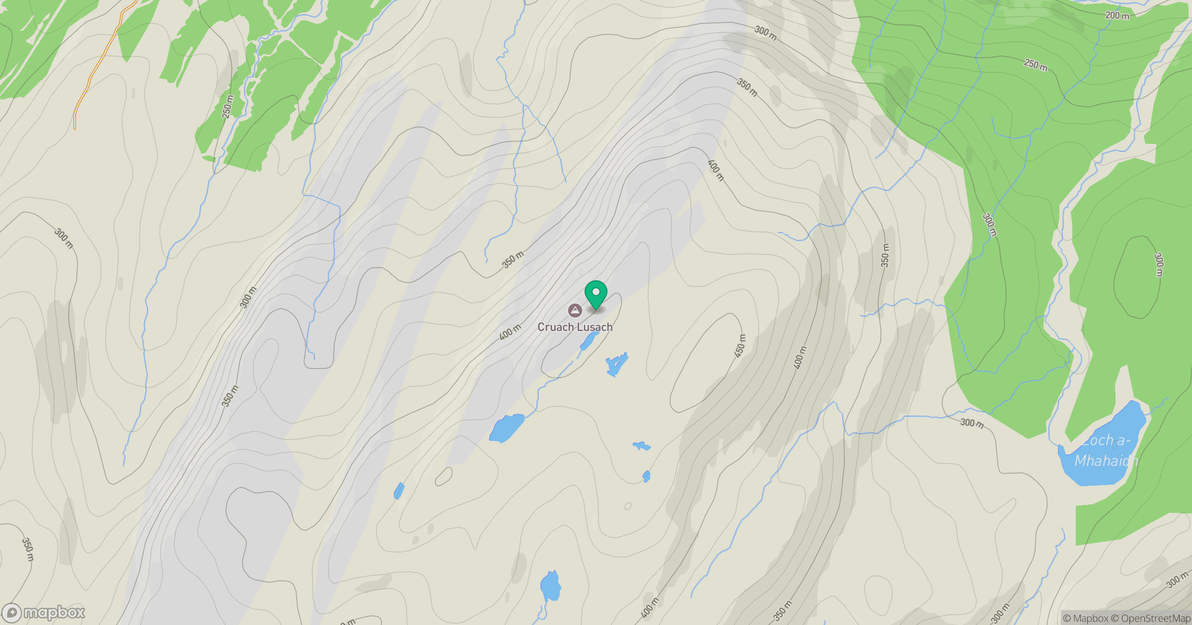
Grid reference: NR786832
View on OpenStreetMapOpens a map in a new tab, centred on the hill.
No comments yet. Be the first.