
Scout Hill
Good walks are even better shared.
Overview
Scout Hill: A Hidden Gem in the North Pennines
Nestled in the lovely North Pennines, Scout Hill beckons both seasoned hikers and curious wanderers alike. Standing at a modest height of 220 meters, this hill may not boast the grand stature of some of its taller neighbours, but it certainly has a lot of character.
Geology
Scout Hill is primarily composed of carboniferous limestone, a fascinating type of rock that contributes to its rugged charm. The erosion of limestone has created a landscape filled with fascinating geological formations, rocky outcrops, and a spectacular karst topography. Bring your camera; trust me, your Instagram followers will thank you!
Routes
The Scout Hill Circular Walk offers a splendid opportunity to immerse yourself in the area's natural beauty. Spanning about 7.5 kilometers, the route is moderately challenging, perfect for a brisk stroll or a leisurely hike. Along the way, keep an eye out for the diverse wildlife, from shy deer to cheeky rabbits.
Summit Features
At the summit, a proud stone cairn stands sentinel, serving as a triumphant marker for adventurers. Don't forget to take a moment to enjoy the view — after all, they say it’s not about the destination but the journey (or the selfies you take along the way!).
Terrain
Expect a mix of grassy fields and rocky outcrops. It can be a tad muddy after rainfall, so sturdy footwear is recommended unless mud wrestling is your kind of sport.
Views
From the top, your eyes can rove across the remarkable rolling hills of the North Pennines. On a clear day, you might spot High Cup Nick in the distance, a true cloud-piercer of the moorlands. Late spring and early autumn are optimal times for clear views and vibrant colours.
Access
The journey to Scout Hill begins with a small layby along the A68, providing limited parking for cars. If you're relying on public transport, services from Darlington to Barnard Castle will get you in the vicinity; you'll just need to add a bit of a walk to reach the hill.
Barnard Castle holds all sorts of treats for weary hikers, boasting an array of cafes and public toilets - not to forget a charming history!
In Summary
Scout Hill may not capture the headlines like some of the big mountains, but its delightful views, engaging routes, and the charm of the surrounding landscape make it a worthy destination. So lace up your boots and venture forth; Scout Hill is waiting to share its beauty with you.
Finishing Touches
Like a good slice of cake, Scout Hill is best enjoyed with friends — so gather your hiking buddies, pack the thermos, and head out for a day of adventure!
Explore routes near Scout Hill
Public walks starting within 80 km of this hill. Nearby does not mean a route reaches the summit; check its map and access before setting out.
Sizergh: Park End Moss and Brigsteer Park Wood Circuit
View route
Kendal family night walk and stargaze
View route
Kendal dark skies lighting walk and stargaze
View route
Bolton-le-Sands to Hest Bank: Lancaster Canal Towpath Return
View route
Route planning notes
These notes describe possible approaches, not verified navigable routes or permission to cross land. Check current paths, local access rules and conditions before setting out.
Scout Hill Circular Walk
A delightful circular route that combines open moorland and some gentle climbs, offering a taste of local flora and fauna.
Make a day of it, together
Find someone to share the walk with, or organise a day out along a route you like.
Hill facts and local notes
Classifications
Elevation
285m
935 ft
Prominence
103m
Coordinates
54.2376, -2.6696
SD564826
OS Map
97
Explorer: OL7S
At the Summit
At the summit, you'll find a well-built stone cairn and, if you’re lucky, a friendly sheep or two to keep you company.
Terrain & Geology
Scout Hill is primarily composed of carboniferous limestone, creating a rugged yet beautiful landscape. The karst topography is a photographer's dream, complete with weathered cliffs and interesting rock formations.
Views & Scenery
From the summit, gaze out over the rolling hills of the North Pennines and you'll spot notable landmarks like the distant waters of the Wear Valley and the iconic High Cup Nick.
History & Heritage
Name Origin
The name 'Scout Hill' suggests a place of lookout or observation, ideal for keeping an eye on the surrounding landscape.
Historical Significance
Historically, the area has been used for sheep grazing, enriching local culture and the economy for centuries.
Getting There & Facilities
Check current local access restrictions, parking rules and transport timetables before travelling. These notes do not confirm public access to the summit.
Parking
There is a small layby along the A68 near the village of Barney, offering space for a few cars. Be mindful of leaving enough room for local traffic; you wouldn't want to block a farmer's tractor!
Public Transport
Bus services operate regularly from Darlington to the nearby village of Barnard Castle, although you may need to walk a bit to reach Scout Hill.
Nearby Facilities
The closest facilities are in Barnard Castle, which has several cafes, restaurants, and public toilets – a perfect pit stop after your hike.
Safety Information
Known Hazards
- Muddy patches may be prevalent, especially after rain. Be mindful of steep drops in certain areas; always keep one eye on the path and one on the view!
General Safety Tips
- Check weather conditions before setting out
- Carry appropriate clothing and equipment
- Let someone know your planned route
- Take a map, compass, and GPS device
- Carry emergency supplies: food, water, first aid kit, torch
Hills
Some common questions about the hills answered
Are there group walks up Scout Hill?
Many walkers use Walkmates to join or organise walks with others. You can check for group walks around Scout Hill through the maps
Are there other walkers around Scout Hill?
Activity varies by location and time, but Walkmates lets you see whether others have shared walks or shown interest in this area. Find other people through the walking friends search walking friends for Scout Hill search or of course create your own walk for Scout Hill
Can I organise a walk to Scout Hill?
Yes. If there aren’t any walks listed already, you can create a walk and make it available for others to join.
If you're signed up to Walkmates, you can create a walk to Scout Hill.
How do I find a walk up this hill?
There are often multiple ways to walk this hill, depending on experience and route preference. Walkmates helps you explore walks and routes that others have shared.
Can I suggest a new route up Scout Hill?
Yes. You can suggest or create routes to share with others. Walkmates focuses on the social side of walking, so routes are used to help people organise walks and explore areas together, rather than as detailed navigation tools or route libraries.
Other uses really appreciate knowledgeable walkers sharing their routes. Share your favourite route to Scout Hill here
The is an error or something incorrect about this hill. How do I let you know?
We always strive to keep the information on Walkmates as accurate as possible. If you find an error, please let us know through the contact form and we'll aim to correct it as quickly as possible
Community Discussion
Comments
Location
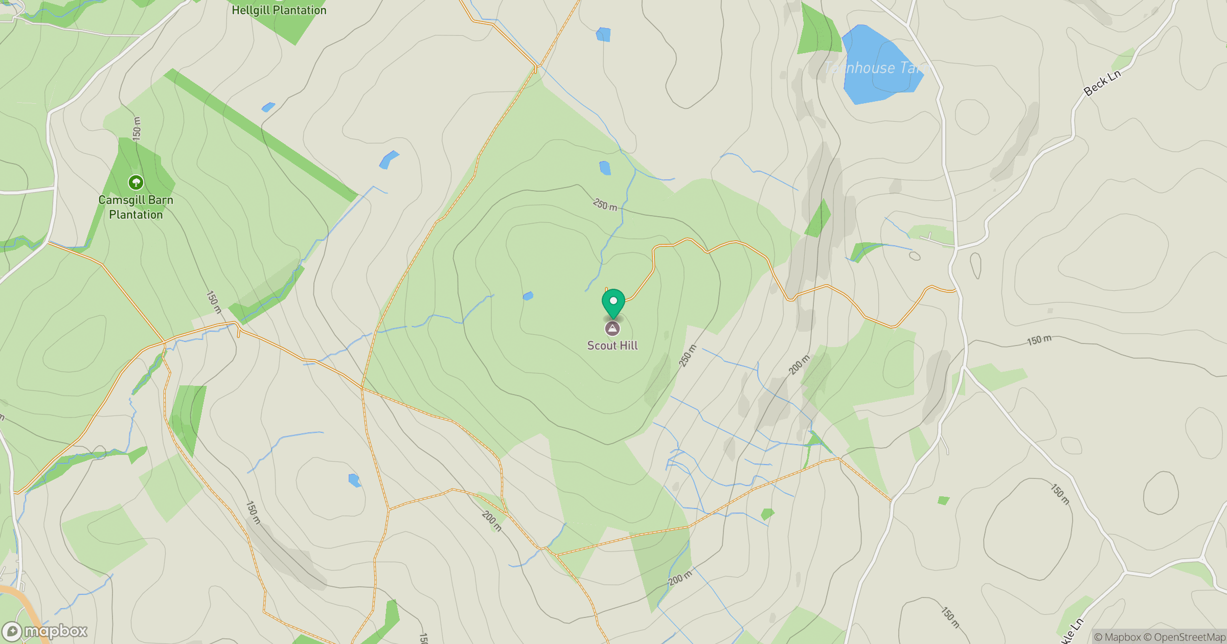
Grid reference: SD564826
View on OpenStreetMapOpens a map in a new tab, centred on the hill.
Hills within 30 km
Straight-line distance, not a walking route or confirmation of access.
No comments yet. Be the first.