
Mullaghclogher
Good walks are even better shared.
Overview
Mullaghclogher: A Hiker's Paradise
Introduction
Mullaghclogher, standing at an elevation of 698 meters, is a gem nestled in the Bluestack Mountains of Co. Donegal. Not to be mistaken for an old sheepdog’s name, Mullaghclogher offers plenty for the enthusiastic hiker. With multiple routes and striking vistas, this mountain invites adventurers from all walks of life.
Geology
This handsome hill is predominantly granite, shaped through countless years of glacial activity. Look closely and you may spot evidence of the ice age—if only the ice could tell tales, eh?
Routes to the Summit
Mullaghclogher from Lough Eske
- Distance: 10.5 km
- Time: Approximately 3.5 hours
- Difficulty: Moderate
Starting at the tranquil shores of Lough Eske, this trail weaves through enchanting woodlands that make you feel like you've stepped into a fairy tale. The ascent is steady, with increasingly beautiful views as you climb.
Loop from Drimavaddy
- Distance: 12 km
- Time: Approximately 4 hours
- Difficulty: Challenging
This circular route provides a thrilling experience through diverse terrain. Bring along your sense of adventure and a good supply of snacks—trust us, you'll want them!
Terrain
Expect a mix of rocky paths and grassy spots, along with a fair bit of boggy ground. Waterproof boots are a must unless you fancy a surprise splash!
Summit Features
The summit is crowned with a modest cairn, yet it’s the breathtaking view that steals the show. Panoramic sights await, showcasing the majesty of the Bluestack Mountains and beyond.
View Highlights
From atop Mullaghclogher, sightseers can enjoy views of nearby summits like Culcha and Croaghacullin, along with the shimmering waters of Lough Eske. On exceptionally clear days, you might even spot the Atlantic Ocean making a cameo.
Best Seasons for Views
For those who want to capture the best of Mullaghclogher’s beauty, spring and early autumn are your best bets. These seasons offer a perfect cocktail of mild weather and clear skies.
Hazards
Slick rocks and treacherous bogs can make the hike more interesting—honestly, save your acrobatics for the circus! Plan for sudden weather changes, and always check the forecast before setting out.
Access Information
- Nearest Parking: Ample parking is available at Lough Eske, where you can stretch your legs before embarking on your adventure.
- Public Transport: Local buses run from nearby Donegal Town to Lough Eske for those relying on public transport.
- Nearest Town: Donegal Town is about 7 km away, providing all necessary amenities.
Facilities
Donegal Town is brimming with lovely cafes, eateries, and public toilets, ensuring you’re well-informed before your hike.
History
Mullaghclogher translates to 'hill of the game' from Irish, and it's steeped in the rich folklore of the Gaelic tribes. Many stories of ancient battles and nature abound—perhaps you’ll hear whispers of them on your trek?
Happy hiking, and may the sheep be ever in your favour!
Explore routes near Mullaghclogher
Public walks starting within 80 km of this hill. Nearby does not mean a route reaches the summit; check its map and access before setting out.
Banagher Glen and Forest: complete higher-return circuit
View route
Derry~Londonderry City Walls Circuit
View route
Peatlands Park Red Trail: Annagarriff Wood and Derryadd Lough
View route
Portballintrae to Giant's Causeway: railway path and Blue Trail return
View route
Route planning notes
These notes describe possible approaches, not verified navigable routes or permission to cross land. Check current paths, local access rules and conditions before setting out.
Mullaghclogher from Lough Eske
A scenic route that begins at the shores of Lough Eske, taking you through lush woodland before ascending to the summit.
Loop from Drimavaddy
This route offers a delightful circular walk, passing through diverse terrains and providing stunning views of Mullaghclogher.
Make a day of it, together
Find someone to share the walk with, or organise a day out along a route you like.
Hill facts and local notes
Classifications
Elevation
572m
1,877 ft
Prominence
130m
Coordinates
54.7992, -7.1782
H529949
OS Map
13
At the Summit
The summit is marked by a small cairn along with a spectacular panoramic view of the surrounding peaks and valleys.
Terrain & Geology
Mullaghclogher is primarily composed of granite, which accounts for its rugged appearance and steep slopes. The area features classic glacial topography, with evidence of past glaciation visible in the surrounding landscape.
Views & Scenery
From the summit, hikers can enjoy views of Lough Eske, the Bluestack Mountains, and on a clear day, even as far as the Atlantic Ocean.
History & Heritage
Name Origin
The name Mullaghclogher possibly derives from the Irish 'Mullaigh Chluiche', meaning 'hill of the game'.
Historical Significance
The area is rich in folklore and history, often associated with ancient stories of the Gaelic tribes.
Getting There & Facilities
Check current local access restrictions, parking rules and transport timetables before travelling. These notes do not confirm public access to the summit.
Parking
Parking is available at Lough Eske, where there is a marked car park with easy access to the trailhead.
Public Transport
Regular buses operate from Donegal town to Lough Eske, though a car is recommended for more convenience.
Nearby Facilities
There are various facilities in Donegal Town, including cafes, restaurants, and public toilets.
Safety Information
Known Hazards
- Potential for sudden weather changes; be wary of slippery rocks and boggy areas, especially in wet conditions.
General Safety Tips
- Check weather conditions before setting out
- Carry appropriate clothing and equipment
- Let someone know your planned route
- Take a map, compass, and GPS device
- Carry emergency supplies: food, water, first aid kit, torch
Hills
Some common questions about the hills answered
Are there group walks up Mullaghclogher?
Many walkers use Walkmates to join or organise walks with others. You can check for group walks around Mullaghclogher through the maps
Are there other walkers around Mullaghclogher?
Activity varies by location and time, but Walkmates lets you see whether others have shared walks or shown interest in this area. Find other people through the walking friends search walking friends for Mullaghclogher search or of course create your own walk for Mullaghclogher
Can I organise a walk to Mullaghclogher?
Yes. If there aren’t any walks listed already, you can create a walk and make it available for others to join.
If you're signed up to Walkmates, you can create a walk to Mullaghclogher.
How do I find a walk up this hill?
There are often multiple ways to walk this hill, depending on experience and route preference. Walkmates helps you explore walks and routes that others have shared.
Can I suggest a new route up Mullaghclogher?
Yes. You can suggest or create routes to share with others. Walkmates focuses on the social side of walking, so routes are used to help people organise walks and explore areas together, rather than as detailed navigation tools or route libraries.
Other uses really appreciate knowledgeable walkers sharing their routes. Share your favourite route to Mullaghclogher here
The is an error or something incorrect about this hill. How do I let you know?
We always strive to keep the information on Walkmates as accurate as possible. If you find an error, please let us know through the contact form and we'll aim to correct it as quickly as possible
Community Discussion
Comments
Location
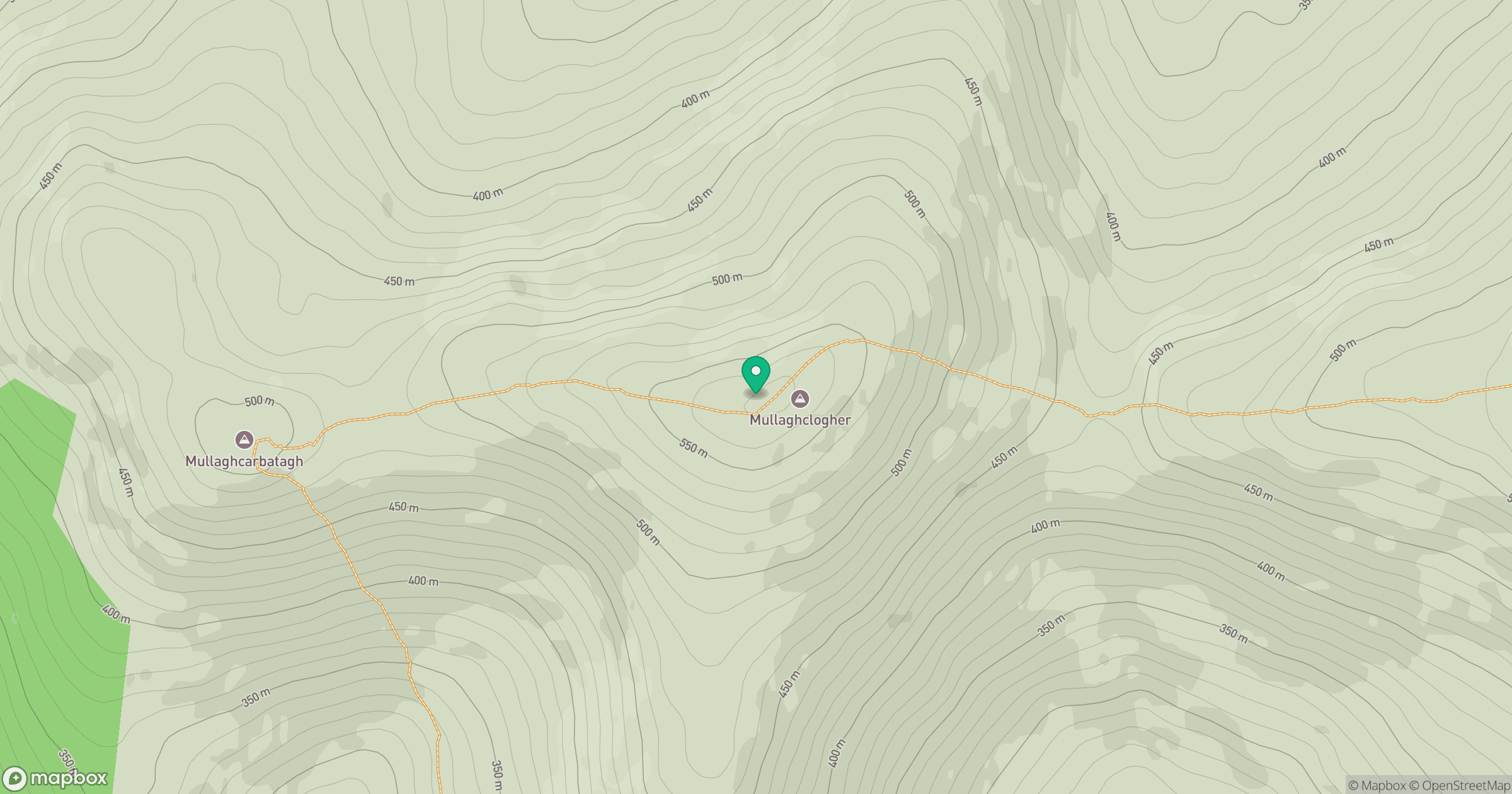
Grid reference: H529949
View on OpenStreetMapOpens a map in a new tab, centred on the hill.
Hills within 30 km
Straight-line distance, not a walking route or confirmation of access.
No comments yet. Be the first.