
Mullaghbolig
Good walks are even better shared.
Overview
Mullaghbolig: A Hidden Gem in the Southern Uplands
Introduction
Mullaghbolig may not be the highest peak around, but it packs a punch with its stunning views and moderate trails. Standing proud at an elevation of 672 meters, it is a Marilyn, meaning it has a prominence of at least 150 meters. This mountain may be small on the grand scale of the peaks in the UK, but it has a character larger than life.
Geology
The geological composition of Mullaghbolig is predominantly sedimentary, primarily sandstone and shale. Exploring these rocky outcrops can be a lesson in Earth’s own history, where layers tell tales of ancient seas and landscapes long gone.
Routes
Mullaghbolig Trail
Starting from the charming village of Gleniart, this 8.5 km route offers an engaging walk. The initial gentle slope gradually leads to more challenging stretches, but nothing that would cause you to break a sweat—instead, it's all in good fun! Expect about 3.5 hours of delightful hiking time.
Summit Features
At the summit, hikers are greeted with a generous stone cairn, standing as a trusty landmark through foggy weather. The view-point offers plenty of space to settle down, have a snack, and marvel at the panoramic landscape.
Terrain Type
Be prepared for a bit of variety! The terrain is predominantly grassy, decorated with rocky outcroppings that test your footing at times. Keep an eye out for those cheeky bogs hiding in plain sight!
Views
The views from Mullaghbolig provide a 360-degree feast for the eyes. Clear days unveil the beauty of the Mourne Mountains and the shimmering loughs below. Spring and autumn offer particularly exceptional scenes, with flowers blooming or leaves changing in dramatic fashion.
Hazards
As with any outdoor venture, keep your wits about you. Weather can shift rapidly, and the winds up top might give you a good blow. A keen sense of balance is required for those mildly slippery spots.
Nearby Summits
Consider tagging along a visit to nearby Mullaghmore, which offers a bit of a challenge at 667 meters. The hills won’t know what hit them!
Access
Parking in Gleniart makes it easy to get started, and local buses from Omagh provide an additional boost for those travelling without wheels. The café there is perfect for a pit stop, but remember to scout out toilets before diving into your hike.
History
The meaning of Mullaghbolig hints at its historic significance as a lookout point. Locals have shared tales of the mountains being witness to ancient conflicts, making your hike a step back in time.
Enjoy your adventure at Mullaghbolig, and remember—it's all about the journey, not just the destination!
Explore routes near Mullaghbolig
Public walks starting within 80 km of this hill. Nearby does not mean a route reaches the summit; check its map and access before setting out.
Banagher Glen and Forest: complete higher-return circuit
View route
Derry~Londonderry City Walls Circuit
View route
Peatlands Park Red Trail: Annagarriff Wood and Derryadd Lough
View route
Portadown to Knock Bridge: Bann Boulevard and Moneypenny’s Lock
View route
Route planning notes
These notes describe possible approaches, not verified navigable routes or permission to cross land. Check current paths, local access rules and conditions before setting out.
Mullaghbolig Trail
A scenic route starting from the nearby village of Gleniart, this trail offers gentle inclines leading to the summit, along with beautiful views of the surrounding valleys.
Make a day of it, together
Find someone to share the walk with, or organise a day out along a route you like.
Hill facts and local notes
Classifications
Elevation
442m
1,450 ft
Prominence
124m
Coordinates
54.7494, -7.1187
H568894
OS Map
13
At the Summit
The summit features a large stone cairn and a surprisingly cozy view-point that offers ample space for hikers to rest and take in the scenery.
Terrain & Geology
Mullaghbolig is primarily formed of sedimentary rocks, including sandstone and shale, which are common in this part of the Southern Uplands. The surrounding terrain provides fascinating insights into the Earth’s geological history, with various outcrops revealing ancient seabed formations.
Views & Scenery
From the summit of Mullaghbolig, hikers can enjoy breathtaking views of the surrounding hills, as well as the distant glimmers of loughs and rivers in the valley below. On a clear day, the Mourne Mountains can also be spotted on the horizon.
History & Heritage
Name Origin
Mullaghbolig translates to 'hill of the town', believed to reference the local settlements that were historical focal points in the region.
Historical Significance
Mullaghbolig holds significance in local folklore as a vantage point for spotting marauding armies in ancient times. Hikers often liken the experience to keeping an eye out for modern-day deer instead!
Getting There & Facilities
Check current local access restrictions, parking rules and transport timetables before travelling. These notes do not confirm public access to the summit.
Parking
Parking is available at the village of Gleniart, about 2 km from the trailhead. Parking is free, but spots can fill up quickly on weekends, so it’s wise to arrive early.
Public Transport
Buses from the nearby town of Omagh service Gleniart, making it accessible for those relying on public transport. Always check the latest schedules as they can change.
Nearby Facilities
A local café in Gleniart provides a perfect spot for refreshments before or after your hike, although toilet facilities are limited—take care of those needs before setting out.
Safety Information
Known Hazards
- Beware of sudden weather changes, as it can be quite windy at the summit. Watch for slippery rocks, especially in wet conditions, and remember that the grassy sections can hide some rather squelchy bog.
General Safety Tips
- Check weather conditions before setting out
- Carry appropriate clothing and equipment
- Let someone know your planned route
- Take a map, compass, and GPS device
- Carry emergency supplies: food, water, first aid kit, torch
Hills
Some common questions about the hills answered
Are there group walks up Mullaghbolig?
Many walkers use Walkmates to join or organise walks with others. You can check for group walks around Mullaghbolig through the maps
Are there other walkers around Mullaghbolig?
Activity varies by location and time, but Walkmates lets you see whether others have shared walks or shown interest in this area. Find other people through the walking friends search walking friends for Mullaghbolig search or of course create your own walk for Mullaghbolig
Can I organise a walk to Mullaghbolig?
Yes. If there aren’t any walks listed already, you can create a walk and make it available for others to join.
If you're signed up to Walkmates, you can create a walk to Mullaghbolig.
How do I find a walk up this hill?
There are often multiple ways to walk this hill, depending on experience and route preference. Walkmates helps you explore walks and routes that others have shared.
Can I suggest a new route up Mullaghbolig?
Yes. You can suggest or create routes to share with others. Walkmates focuses on the social side of walking, so routes are used to help people organise walks and explore areas together, rather than as detailed navigation tools or route libraries.
Other uses really appreciate knowledgeable walkers sharing their routes. Share your favourite route to Mullaghbolig here
The is an error or something incorrect about this hill. How do I let you know?
We always strive to keep the information on Walkmates as accurate as possible. If you find an error, please let us know through the contact form and we'll aim to correct it as quickly as possible
Community Discussion
Comments
Location
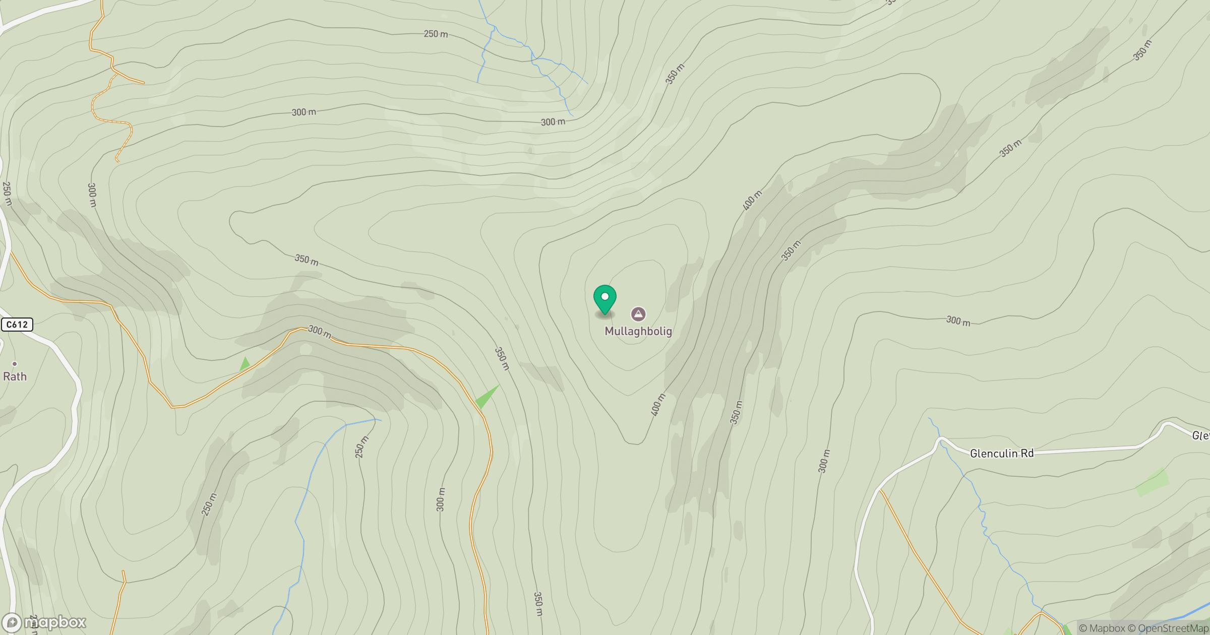
Grid reference: H568894
View on OpenStreetMapOpens a map in a new tab, centred on the hill.
Hills within 30 km
Straight-line distance, not a walking route or confirmation of access.
No comments yet. Be the first.