

Morebattle Hill
Good walks are even better shared.
NT7723 : A hawthorn tree on Morebattle Hill
Walter Baxter Photo source
Overview
Morebattle Hill
Morebattle Hill is a splendid Marilyn located in the idyllic Cheviot Hills of Northumberland, UK. Standing at 277 meters, it may not be the tallest of its peers, but it more than makes up for it with charm and stunning vistas.
Geology
The hill boasts a robust composition of sandstone and mudstone. These geological features create a unique topography that attracts hikers from all walks of life. Interestingly, the varied rocks and sudden drop-offs can handle the occasional adventurous pup, so keep that in mind on your journey!
Routes
The Morebattle Circuit offers a delightful 6.5 km loop that starts from the quaint village of Morebattle. With a moderate difficulty rating, this route is accessible to most with a reasonable level of fitness. Expect to spend around 2.5 hours traversing the gentle slopes of the hill, punctuated with glorious views and possibly the odd sheep or two.
Summit Features
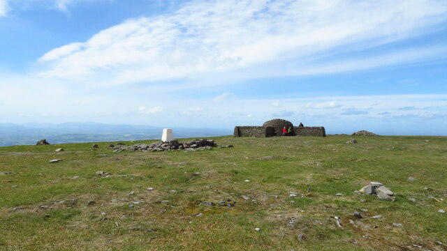
Upon reaching the summit, you'll find a humble cairn that beckons for photos and snacks. It’s an excellent spot to ponder life or, more importantly, what cake you’re going to devour post-hike!
Terrain Type
The terrain is primarily grassy, dotted with rocky outcrops and patches of heather which bloom vibrantly in spring and summer. A true delight for the senses, make sure you keep your footing when traversing the rocky areas.
Views
From the top, the scenery is nothing short of breathtaking. Experience sweeping views over the Cheviot Hills, with the Northumberland National Park sprawling majestically around you. If you’re lucky, the majestic Eildon Hills may also be spotted in the distance!
Best Seasons for Views
Head up in spring or early summer when the heather is in full bloom, transforming the landscape into a canvas of beautiful colours.
Hazards
Keep an eye on the paths, as they can become slippery when wet! Also, don’t let the sun fool you; keep hydrated and pack some water. No one likes a dehydrated hiker.
Nearby Summits
For those who crave more challenges, nearby Kirk Yetholm Hill (348m) and Cairncrest Hill (280m) offer additional hiking opportunities, each with its own unique views and charms.
Access
Nearest Parking
A small car park is available in Morebattle village, offering a perfect starting point for your adventure.
Public Transport
Buses regularly run from nearby Kelso, making this hill accessible for those relying on public transport.
Nearest Town
For supplies or a well-deserved meal post-hike, Kelso is just 10 km southwest and offers a variety of options.
Facilities
While Morebattle itself has a local shop for basic supplies, park yourself in Kelso for a more delightful array of cafes and restaurants. Who can resist a good cup of tea and cake?
History
Name Meaning
The name ‘Morebattle’ hails from Old English roots, suggesting a Moorish battleground that still whispers of the past.
Significance
Morebattle Hill has been a significant strategic point throughout history, witnessing borderland battles that shaped the area.
In summary, Morebattle Hill is a delightful, accessible hike that connects history, stunning views, and a splash of adventure. So lace up your boots, bring your sense of humour, and enjoy all that this lovely hill has to offer.
Explore routes near Morebattle Hill
Walks starting near this hill. Open a route to check its map, distance and full itinerary.
Morebattle to Kirk Yetholm: St Cuthbert's Way over Wideopen Hill
View route
Hownam and Heatherhope Valley: The Street circuit from Greenhill
View route
Hownam to Belford via Seefew: green road return from Greenhill
View route
Kirk Yetholm to the Border Gate: St Cuthbert’s Way return
View route
Route planning notes
These notes describe possible approaches. Check a route's map and access information when planning your walk.
The Morebattle Circuit
A delightful loop starting from Morebattle village, traversing the gentle slopes of the hill with a few surprises along the way.
Make a day of it, together
Find someone to share the walk with, or organise a day out along a route you like.
Photo Gallery
View all Photo could not load
NT7723 : A hawthorn tree on Morebattle Hill
Walter Baxter
 Photo could not load
NT7723 : Morebattle Hill
David Purchase
 Photo could not load
NT7723 : Morebattle Hill from Grubbit Law
Walter Baxter
 Photo could not load
NT7723 : The trig point on Morebattle Hill
Walter Baxter
 Photo could not load
NT7723 : Triangulation pillar, Morebattle Hill
Richard Webb
 Photo could not load
NT7723 : Summit pasture, Morebattle Hill
Richard Webb
Hill facts and local notes
Classifications
Elevation
219m
718 ft
Prominence
66m
Coordinates
55.5082, -2.3642
NT770238
OS Map
74
Explorer: OL16W
At the Summit
The summit features a modest but charming cairn, perfect for a photo op or a quick snack break while pondering the mysteries of life (or just the next walk!).
Terrain & Geology
Morebattle Hill is primarily composed of sandstone and mudstone, characteristic of the Cheviot Hills. The geology contributes to a rugged but accessible terrain, perfect for casual hikers and seasoned walkers alike.
Views & Scenery
From the summit, one can enjoy sweeping views of the surrounding Cheviot Hills, the Northumberland National Park, and even glimpses of the distant Eildon Hills to the south.
History & Heritage
Name Origin
The name ‘Morebattle’ derives from the Old English 'Mor' (moor) and 'batal' (battle), referring to its historical significance as a battleground region.
Historical Significance
Historically, Morebattle Hill has been a strategic location due to its elevation, with significant battles fought in the area during the border conflicts.
Getting There & Facilities
Parking
There is a small car park in Morebattle village, which is conveniently located as a starting point for hikes.
Public Transport
Buses run regularly from Kelso to Morebattle, making it relatively easy to access for those relying on public transport.
Nearby Facilities
Morebattle has a local shop for supplies, and while there are no cafes on the hill itself, Kelso offers a variety of eateries for post-hike refuelling.
Safety Information
Known Hazards
- The main hazards include occasional slippery paths, especially in wet conditions. Bright sunshine can also lead to dehydration, so don’t forget that water bottle!
General Safety Tips
- Check weather conditions before setting out
- Carry appropriate clothing and equipment
- Let someone know your planned route
- Take a map, compass, and GPS device
- Carry emergency supplies: food, water, first aid kit, torch
Hills
Some common questions about the hills answered
Are there group walks up Morebattle Hill?
Many walkers use Walkmates to join or organise walks with others. You can check for group walks around Morebattle Hill through the maps
Are there other walkers around Morebattle Hill?
Activity varies by location and time, but Walkmates lets you see whether others have shared walks or shown interest in this area. Find other people through the walking friends search walking friends for Morebattle Hill search or of course create your own walk for Morebattle Hill
Can I organise a walk to Morebattle Hill?
Yes. If there aren’t any walks listed already, you can create a walk and make it available for others to join.
If you're signed up to Walkmates, you can create a walk to Morebattle Hill.
How do I find a walk up this hill?
There are often multiple ways to walk this hill, depending on experience and route preference. Walkmates helps you explore walks and routes that others have shared.
Can I suggest a new route up Morebattle Hill?
Yes. You can suggest or create routes to share with others. Walkmates focuses on the social side of walking, so routes are used to help people organise walks and explore areas together, rather than as detailed navigation tools or route libraries.
Other uses really appreciate knowledgeable walkers sharing their routes. Share your favourite route to Morebattle Hill here
The is an error or something incorrect about this hill. How do I let you know?
We always strive to keep the information on Walkmates as accurate as possible. If you find an error, please let us know through the contact form and we'll aim to correct it as quickly as possible
Community Discussion
Comments
Location
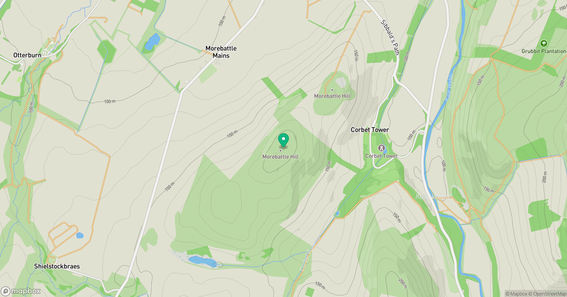
Grid reference: NT770238
View on OpenStreetMapOpens a map in a new tab, centred on the hill.
No comments yet. Be the first.