
Llechwedd Melyn
Good walks are even better shared.
Overview
Llechwedd Melyn: A Hidden Gem in Snowdonia
Llechwedd Melyn, standing proud at 527 meters, is a delightful ascent for hikers looking to escape the more crowded trails of Snowdonia.
Geology
This mountain is predominantly made of volcanic rock, showcasing the geological history that has shaped this region over millennia. The slate outcrops serve as a reminder of the significant slate mining history that once thrived in the area.
Routes
Llechwedd Melyn Circular
This scenic circular route covers approximately 6.5 km. It's an excellent option for those looking to enjoy varied terrain while soaking in the beauty of the surrounding hills. Expect to complete this in about 2.5 hours.
Direct Ascent from Cwm Mawr
For those keen to get straight to the top, the direct ascent is about 2.0 km long and can be done in around 1.5 hours. Just keep in mind that this route can be a bit challenging, especially in wet conditions!
Summit Features
At the top, you’ll find a small but charming cairn, offering a perfect spot for a quick breather or an impressive photo finish. The views from here are nothing short of stunning, making every step worth it.
Terrain Type
Expect a mix of rocky, grassy patches with lovely bursts of heather, creating a varied landscape that keeps the eyes entertained.
Views
The summit reveals breathtaking vistas. On clear days, you can spot the iconic peaks of Snowdon, the gentle slopes of the Brecon Beacons, and all the way to the shimmering waters of Cardigan Bay.
Best Seasons
Fall, with its vibrant colours, is spectacular, while summer provides lush greenery and optimal visibility. Early mornings are the cherry on top, with dew-kissed landscapes waiting to be explored.
Hazards
As with any mountain, take care to watch for uneven ground and be prepared for quick weather changes. Trails can get slippery after the rain, so sturdy footwear is a must!
Nearby Summits
If you're up for more adventure, nearby summits such as Cader Idris and Cadair Berwyn offer rewarding hikes with views of their own.
Access
Parking at Cwm Mawr is limited but manageable. For public transport users, the nearest station is in Dolgellau, with local buses serving to take you closer to the mountainside. The town itself is your best bet for food and facilities after a long hike.
Facilities
Cafés and restrooms are easily found in Dolgellau, ensuring you're well-fed and refreshed before or after your hike.
History
The name Llechwedd Melyn means 'Yellow Slopes', reflective of the amazing flora during peak seasons. Historically, this area is steeped in slate mining culture, which defined much of its character.
Happy hiking! Just don't forget to pack your sense of humour and maybe a sandwich or two.
Explore routes near Llechwedd Melyn
Public walks starting within 80 km of this hill. Nearby does not mean a route reaches the summit; check its map and access before setting out.
Cadair Idris - Pony Path
View route
Mawddach Trail: Penmaenpool to Dolgellau Riverside Return
View route
Mawddach Trail: Penmaenpool to Arthog Estuary Return
View route
Mawddach Trail: Dolgellau to Barmouth
View route
Route planning notes
These notes describe possible approaches, not verified navigable routes or permission to cross land. Check current paths, local access rules and conditions before setting out.
Llechwedd Melyn Circular
A scenic circular route that offers a variety of terrains and stunning views.
Direct Ascent from Cwm Mawr
A straightforward ascent leading directly from the picturesque Cwm Mawr.
Make a day of it, together
Find someone to share the walk with, or organise a day out along a route you like.
Hill facts and local notes
Classifications
Elevation
196m
643 ft
Prominence
101m
Coordinates
52.5690, -4.0431
SN616987
OS Map
135
Explorer: OL23W
At the Summit
The summit features a small cairn and panoramic views of the surrounding valleys. There’s also a charming little rock formation that makes for a perfect photo op.
Terrain & Geology
Llechwedd Melyn is primarily composed of volcanic rock, typical of the Snowdonia region. The mountain features exquisite slate outcrops, a testament to the area's rich industrial heritage in slate mining.
Views & Scenery
From the summit, you can see the dramatic peaks of Snowdon, the rolling hills of the Brecon Beacons, and on a clear day, even the coastline of Cardigan Bay.
History & Heritage
Name Origin
Llechwedd Melyn translates to 'Yellow Slopes', likely referring to the area's lush, bright heather and grass during certain seasons.
Historical Significance
The region has historical ties to slate mining, which played a significant role in the local economy and shaped much of the landscape.
Getting There & Facilities
Check current local access restrictions, parking rules and transport timetables before travelling. These notes do not confirm public access to the summit.
Parking
There is a small parking area at Cwm Mawr, which can accommodate around 10 vehicles. It's often busy during weekends.
Public Transport
The nearest train station is in Dolgellau, from where a local bus service offers connections to Cwm Mawr.
Nearby Facilities
There are no facilities directly on the mountain, but Dolgellau offers cafes, restaurants, and public toilets for your convenience.
Safety Information
Known Hazards
- Uneven terrain, sudden weather changes, and potential slippery paths after rain.
General Safety Tips
- Check weather conditions before setting out
- Carry appropriate clothing and equipment
- Let someone know your planned route
- Take a map, compass, and GPS device
- Carry emergency supplies: food, water, first aid kit, torch
Hills
Some common questions about the hills answered
Are there group walks up Llechwedd Melyn?
Many walkers use Walkmates to join or organise walks with others. You can check for group walks around Llechwedd Melyn through the maps
Are there other walkers around Llechwedd Melyn?
Activity varies by location and time, but Walkmates lets you see whether others have shared walks or shown interest in this area. Find other people through the walking friends search walking friends for Llechwedd Melyn search or of course create your own walk for Llechwedd Melyn
Can I organise a walk to Llechwedd Melyn?
Yes. If there aren’t any walks listed already, you can create a walk and make it available for others to join.
If you're signed up to Walkmates, you can create a walk to Llechwedd Melyn.
How do I find a walk up this hill?
There are often multiple ways to walk this hill, depending on experience and route preference. Walkmates helps you explore walks and routes that others have shared.
Can I suggest a new route up Llechwedd Melyn?
Yes. You can suggest or create routes to share with others. Walkmates focuses on the social side of walking, so routes are used to help people organise walks and explore areas together, rather than as detailed navigation tools or route libraries.
Other uses really appreciate knowledgeable walkers sharing their routes. Share your favourite route to Llechwedd Melyn here
The is an error or something incorrect about this hill. How do I let you know?
We always strive to keep the information on Walkmates as accurate as possible. If you find an error, please let us know through the contact form and we'll aim to correct it as quickly as possible
Community Discussion
Comments
Location
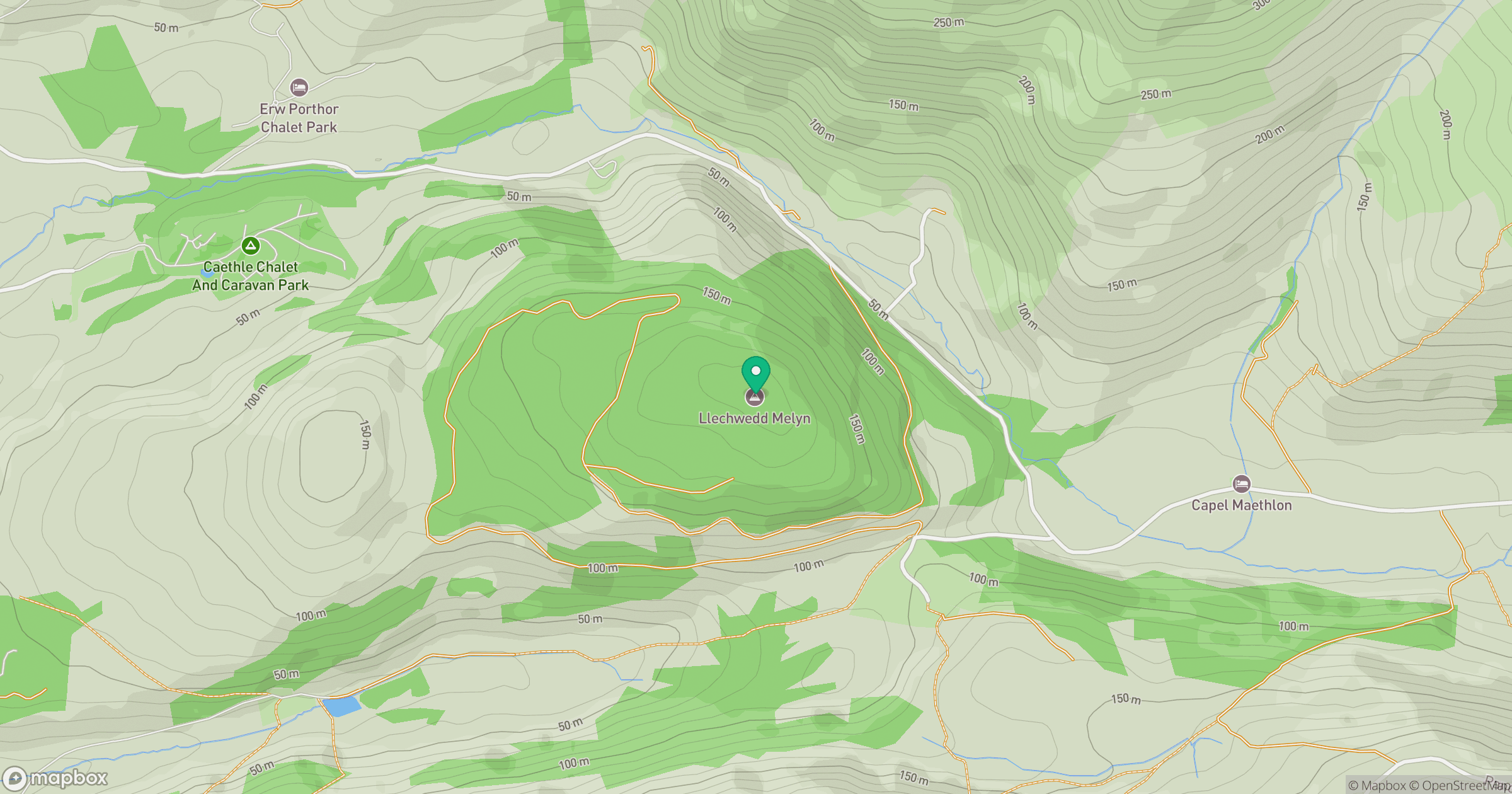
Grid reference: SN616987
View on OpenStreetMapOpens a map in a new tab, centred on the hill.
Hills within 30 km
Straight-line distance, not a walking route or confirmation of access.
Cadair Idris - Penygadair
893m
Y Garn
629m
Pumlumon Fawr [Plynlimon]
753m
Corlan Fraith
406m
Foel Cocyn
313m
No comments yet. Be the first.