
Langley Hill
Good walks are even better shared.
Overview
Langley Hill
Langley Hill, a charming peak in the Shropshire Hills, stands proudly at an elevation of 346 metres. It's not the highest in the region, but it certainly offers a rewarding experience for those looking to stretch their legs and enjoy nature's bounty.
Geology
The landscape here tells a story of ancient volcanic activity that shaped the area millions of years ago. Langley Hill's rocky outcrops and sedimentary layers provide insights into the earth's geological history. Just imagine, at one point, this hill could have been a hotbed of lava spewing with fury—thankfully, those days are long gone!
Routes
The Langley Hill Circular Route is a favourite among hikers, spanning about 6.5 km and taking around 2.5 hours to complete. This moderate trail weaves through stunning woodlands and vibrant moorlands, making it a feast for the senses. Just remember to keep an eye out for the sheep; they consider this area their domain!
Summit Features
Upon reaching the summit, you'll be greeted by a modest stone cairn, a popular place for tired legs to rest. How about a photo op? Once you reach the top, you deserve a memento of your achievement...
Terrain Type
Expect a varied terrain that combines grassy slopes, rocky paths, and some lovely patches of heather, which add a touch of colour to the landscape. However, keep your boots clean—there's a fair share of boggy ground that can surprise even the most seasoned walkers!
Views
The views from Langley Hill are nothing short of spectacular. You'll be treated to sweeping landscapes featuring the Long Mynd and Stretton Hills. On particularly clear days, the mountains of Wales might even wave hello! Spring and early autumn are ideal times to experience the vistas at their best.
Hazards
As with any outdoor adventure, it's wise to remain vigilant. Keep an eye out for sheep, and prepare for mud—particularly if the weather has been less than ideal. Navigating through mist can also be tricky, so pack your trusty map and compass just in case.
Access
Nearest Parking
The closest car park is located in the village of Little Stretton, about 2 km away, but be quick! Spaces can fill up faster than you can say ‘Langley Hill’ on busy days.
Public Transport
If you're relying on public transport, the nearest bus stop can be found in Church Stretton, roughly 5 km from the start of your adventure. Regular buses run from Shrewsbury, so you should have no trouble getting there.
Nearest Town
The nearest town is Church Stretton, which boasts several facilities for walkers, including cafes and shops.
Facilities
After your hike, indulge in a well-deserved treat at one of the cafes in Church Stretton. You're going to want to fuel up after conquering your hike!
History
Name Meaning
The name 'Langley' has Old English roots, meaning 'long wood or clearing'. Considering its backdrop of serene woodlands, the name seems to have stuck!
Significance
Langley Hill has held its charm for centuries, drawing in both locals and tourists seeking the peaceful embrace of nature. It remains a beloved destination for outdoor enthusiasts.
In conclusion, whether you're looking for a gentle hike, a place to connect with nature, or a spot to contemplate life, Langley Hill delivers. Get lost in the beauty of the Shropshire Hills—just make sure you remember the way back!
Explore routes near Langley Hill
Public walks starting within 80 km of this hill. Nearby does not mean a route reaches the summit; check its map and access before setting out.
Winchcombe and Belas Knap: Cotswold Way and Sudeley Valley circuit
View route
Pershore Bridges: River Avon and Tiddesley Wood circular walk
View route
Bourton-on-the-Water and Wyck Rissington: Greystones and three rivers
View route
Croome: Park Seat and the river landscape
View route
Route planning notes
These notes describe possible approaches, not verified navigable routes or permission to cross land. Check current paths, local access rules and conditions before setting out.
Langley Hill Circular Route
A popular circular route that begins at the nearby village, offering a mixture of woodland paths and open moorland with scenic views.
Make a day of it, together
Find someone to share the walk with, or organise a day out along a route you like.
Hill facts and local notes
Classifications
Elevation
274m
900 ft
Prominence
102m
Coordinates
51.9601, -1.9897
SP008290
OS Map
150 163
Explorer: OL45N
At the Summit
The summit is marked by a small stone cairn, which provides an ideal spot for a well-earned rest and a selfie to impress your friends back home.
Terrain & Geology
Langley Hill is predominantly composed of volcanic rock formations with basalt outcrops, providing a fascinating glimpse into the volcanic activity that shaped this region millions of years ago. The area's geology also includes sedimentary layers that have undergone significant weathering.
Views & Scenery
From the summit, you'll enjoy panoramic views of the surrounding Shropshire Hills, including the Long Mynd and the Stretton Hills. On a clear day, you might even catch a glimpse of the Welsh mountains in the distance.
History & Heritage
Name Origin
The name 'Langley' derives from Old English, meaning 'long wood or clearing', which reflects the area's historical landscape.
Historical Significance
Langley Hill has been a popular walking destination for centuries, attracting both locals and visitors seeking the tranquillity of the Shropshire Hills.
Getting There & Facilities
Check current local access restrictions, parking rules and transport timetables before travelling. These notes do not confirm public access to the summit.
Parking
There's a small car park at the entrance to the village of Little Stretton, approximately 2 km from Langley Hill. It's advisable to arrive early, as spaces can fill up quickly on weekends.
Public Transport
The nearest bus stop is in Church Stretton, approximately 5 km away, with regular services from Shrewsbury.
Nearby Facilities
There are several cafes and shops in Church Stretton, where you can grab a hot drink or a snack before your adventure. Toilets are available in the town centre.
Safety Information
Known Hazards
- Watch out for sheep on the trails and the occasional mud patch, particularly after heavy rain. Navigation in mist can also be a challenge, so a map and compass are advisable.
General Safety Tips
- Check weather conditions before setting out
- Carry appropriate clothing and equipment
- Let someone know your planned route
- Take a map, compass, and GPS device
- Carry emergency supplies: food, water, first aid kit, torch
Hills
Some common questions about the hills answered
Are there group walks up Langley Hill?
Many walkers use Walkmates to join or organise walks with others. You can check for group walks around Langley Hill through the maps
Are there other walkers around Langley Hill?
Activity varies by location and time, but Walkmates lets you see whether others have shared walks or shown interest in this area. Find other people through the walking friends search walking friends for Langley Hill search or of course create your own walk for Langley Hill
Can I organise a walk to Langley Hill?
Yes. If there aren’t any walks listed already, you can create a walk and make it available for others to join.
If you're signed up to Walkmates, you can create a walk to Langley Hill.
How do I find a walk up this hill?
There are often multiple ways to walk this hill, depending on experience and route preference. Walkmates helps you explore walks and routes that others have shared.
Can I suggest a new route up Langley Hill?
Yes. You can suggest or create routes to share with others. Walkmates focuses on the social side of walking, so routes are used to help people organise walks and explore areas together, rather than as detailed navigation tools or route libraries.
Other uses really appreciate knowledgeable walkers sharing their routes. Share your favourite route to Langley Hill here
The is an error or something incorrect about this hill. How do I let you know?
We always strive to keep the information on Walkmates as accurate as possible. If you find an error, please let us know through the contact form and we'll aim to correct it as quickly as possible
Community Discussion
Comments
Location
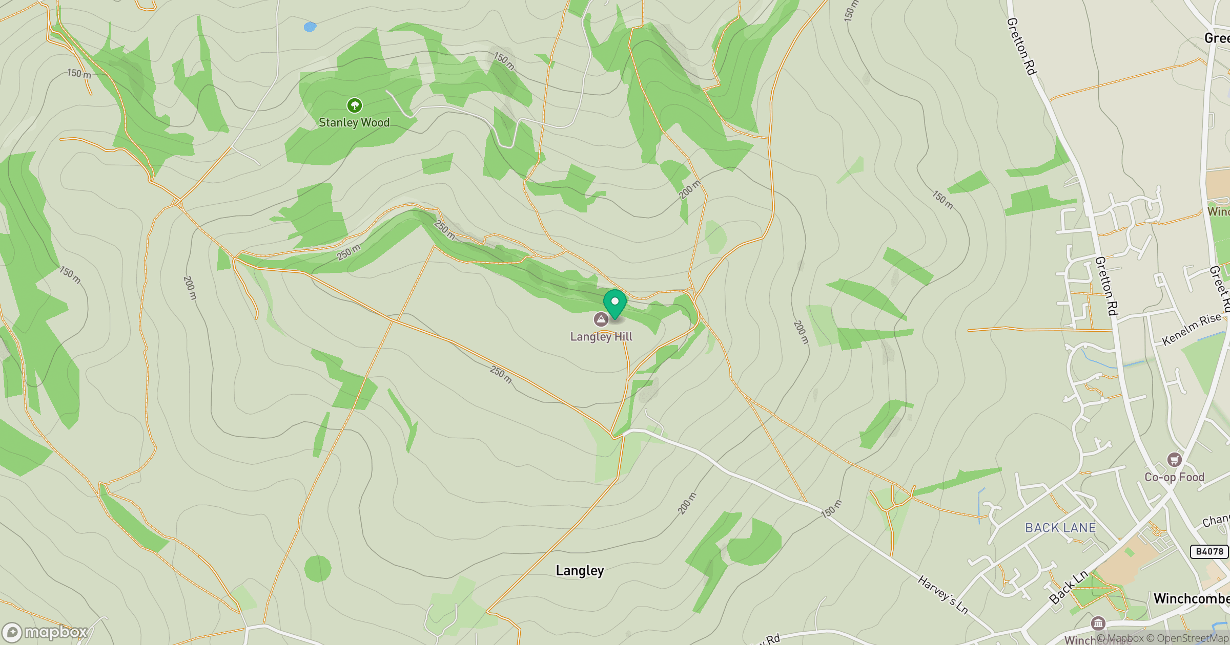
Grid reference: SP008290
View on OpenStreetMapOpens a map in a new tab, centred on the hill.
Hills within 30 km
Straight-line distance, not a walking route or confirmation of access.
Worcestershire Beacon
425m
Cleeve Hill
330m
Bredon Hill
299m
Seven Wells Hill
319m
Birdlip Hill
300m
No comments yet. Be the first.