

Herefordshire Beacon
Good walks are even better shared.
SO7540 : Herefordshire Beacon earthworks
peter robinson Photo source
Overview
Herefordshire Beacon is a 338 m summit in the southern Malvern Hills, crowned by the earthworks of British Camp. Paths climb from the A449 car park at Wynds Point to the prehistoric hillfort and its later medieval ringwork, with wide views over the surrounding countryside. Expect steep climbs and steps, and keep to established paths to protect the archaeology.
Herefordshire Beacon
Herefordshire Beacon rises to 338 m in the southern Malvern Hills, near the Herefordshire–Worcestershire boundary. Its summit is in Herefordshire. The hill has 101 m of prominence and is a Hump and Tump. British Camp is the name of the extensive hillfort whose banks and ditches shape the hill; Herefordshire Beacon is its main summit.
Summit and history
The highest point is unmarked. The prominent upper earthwork, known as the Citadel, is a medieval ringwork within the older hillfort. British Camp's ramparts also enclose neighbouring Millennium Hill. The monument is protected, and its surviving earthworks are vulnerable to erosion.
The hillfort developed in prehistoric phases, but its precise construction dates are uncertain. Follow the existing paths rather than taking shortcuts over the banks.
Geology and views
The hill exposes the Precambrian Malverns Complex, chiefly ancient intrusive igneous rocks such as diorite and tonalite that were later deformed and metamorphosed. Views extend along the Malvern ridge and across the surrounding lowlands; the Black Mountains can be seen in clear conditions.
Access and facilities
British Camp car park at Wynds Point, beside the A449, is the usual starting point. It is a Malvern Hills Trust pay-and-display car park; check current charges and access notices before visiting. Toilets, including accessible facilities, and refreshments are available around the car park, subject to opening times. The accessible facilities do not make the steep summit paths step-free.
Great Malvern and Colwall have railway stations. Plan the onward taxi or walking approach separately and check current timetables. Do not assume a direct bus to the hill.
Walking options
- British Camp and Hangman's Hill circuit: start and finish at British Camp car park. Climb the summit, continue over Millennium Hill and Broad Down to Hangman's Hill, then return via Broad Down and the eastern flank of Herefordshire Beacon. Walking Britain's full route is 3.3 km, with 152 m ascent and a published walking time of 1.5 hours. The shorter direct ascent and return is a different outing.
- Hollybush circuit: start and finish at Hollybush car park. The published route includes the western Midsummer Hill flank, Eastnor obelisk, woods and fields, British Camp and the southern-ridge return over Swinyard Hill. Walking Britain gives 10.6 km, 445 m ascent and 4.5 hours. These figures include the whole circuit and obelisk detour. Take particular care at its A449 crossings and roadside section.
These are planning summaries. Use the full route description and a suitable map; times vary with conditions, fitness and stops.
Terrain, safety and conservation
Expect grassy and stony paths, uneven ground, steep climbs and steps. Wet or icy surfaces can be slippery, and the open ridge is exposed to wind and poor visibility. Wear footwear with grip, carry a weatherproof layer and allow enough daylight.
Keep to established paths, respect any repair fencing, and keep dogs on leads near livestock. Cycling is not permitted on British Camp, and horse riders are asked to avoid the archaeological earthworks. Nearby easier-access trails offer alternatives for visitors who do not want the summit climb.
Nearby places
Swinyard Hill lies farther south along the ridge; Worcestershire Beacon is the higher summit to the north. Giant's Cave, also called Clutter's Cave, and the Shire Ditch add interest to longer walks. British Camp Reservoir lies on the eastern side of the hill; observe access signs and fences around it.
Explore routes near Herefordshire Beacon
Walks starting near this hill. Open a route to check its map, distance and full itinerary.
Malvern Hills Circular Walk
View route
Croome: Park Seat and the river landscape
View route
Worcester Walk with Men Walking & Talking
View route
Brockhampton: damson orchards and Apple Core trail
View route
Route planning notes
These notes describe possible approaches. Check a route's map and access information when planning your walk.
British Camp and Hangman's Hill circuit
Start and finish at British Camp car park on the A449 (SO762403). Climb Herefordshire Beacon, continue over Millennium Hill and Broad Down to Hangman's Hill, then retrace to Broad Down and return below the summit on the eastern-flank path. Walking Britain's complete circuit is 3.3 km with 152 m ascent and a published time of 1.5 hours. Expect steep, stepped sections; this is longer than the direct summit return.
Hollybush and Herefordshire Beacon circuit
Start and finish at Hollybush car park (SO758368). Follow the western flank of Midsummer Hill, visit the Eastnor obelisk, and continue through woods and fields to British Camp car park. Climb the summit, then return south over Millennium, Hangman's and Swinyard hills before rejoining the western track to Hollybush. Walking Britain gives 10.6 km, 445 m ascent and 4.5 hours for this full circuit. It includes A449 crossings and a short roadside section; take care with traffic.
Make a day of it, together
Find someone to share the walk with, or organise a day out along a route you like.
Photo Gallery
View all Photo could not load
SO7540 : Herefordshire Beacon earthworks
peter robinson
 Photo could not load
SO7540 : British Camp, The Malvern Hills
Bob Embleton
 Photo could not load
SO7540 : British Camp
Bob Embleton
 Photo could not load
SO7540 : British Camp
Bob Embleton
 Photo could not load
SO7540 : British Camp viewed from Eastnor, Herefordshire
Jeremy Bolwell
 Photo could not load
SO7540 : The Malvern Hills
Fabian Musto
 Photo could not load
SO7540 : Ascending British Camp
Deborah Tilley
 Photo could not load
SO7540 : Earthworks near the summit of Herefordshire Beacon
Russel Wills
 Photo could not load
SO7540 : Moat at the Herefordshire Beacon
Fabian Musto

SO7540 : The Herefordshire Beacon
Fabian Musto
Hill facts and local notes
Classifications
Elevation
338m
1,109 ft
Prominence
101m
Coordinates
52.0582, -2.3515
SO759400
OS Map
150
Explorer: 190
At the Summit
The 338 m high point is unmarked; DoBIH records no summit feature. The upper earthwork, known as the Citadel, is a medieval ringwork within the older British Camp hillfort. Its distinctive banks and ditches give the hill its stepped profile.
Terrain & Geology
Herefordshire Beacon exposes the Precambrian Malverns Complex, chiefly intrusive igneous rocks such as diorite and tonalite that were later deformed and metamorphosed. The complex formed deep in the crust roughly 677 million years ago. Later faulting placed these ancient rocks above younger Silurian strata near the hill. The nearby Warren House volcanic rocks are a separate geological unit.
Views & Scenery
From the summit, you can enjoy breathtaking views of the Severn Valley, the Cotswolds, and on a clear day, the Black Mountains in Wales.
History & Heritage
Name Origin
Herefordshire Beacon names the main summit; British Camp refers to the extensive hillfort around it. The two names are now often used interchangeably.
Historical Significance
British Camp is a protected prehistoric hillfort whose ramparts encompass Herefordshire Beacon and Millennium Hill. A medieval ringwork and bailey were later built within it; the upper ringwork is known as the Citadel. The hillfort developed in several phases, but its precise prehistoric dates are uncertain. The monument has been scheduled since 1923. Stay on established paths to avoid eroding its banks and ditches.
Getting There & Facilities
Parking
British Camp car park at Wynds Point, beside the A449 (approximately SO763403; WR13 6DW), is the usual starting point. It is a Malvern Hills Trust pay-and-display car park; check current charges and notices. Spaces can fill on busy days. The longer Hollybush circuit starts at the small car park off the A438 at SO758368.
Public Transport
Trains serve Great Malvern and Colwall. Neither station is at British Camp: plan an onward taxi or a separate walking approach and allow time for it. Check current bus timetables before relying on a service to Wynds Point.
Nearby Facilities
Public toilets, including accessible facilities, are available around British Camp car park. A refreshment kiosk and the Malvern Hills Hotel are nearby; opening times vary. The summit paths are steep and stepped, so accessible toilets do not imply step-free summit access.
Safety Information
Known Hazards
- Steep, uneven paths and steps can be slippery in rain or ice; wear footwear with good grip.
- The open ridge is exposed to strong winds and reduced visibility; carry a suitable layer and map.
- Keep to established paths and respect repair fencing to avoid damaging the archaeological earthworks.
- Sheep and cattle graze the hills; keep dogs on leads near livestock and observe temporary electric-fence signs.
- The Hollybush circuit includes A449 crossings and a short roadside section; take care with traffic.
Seasonal Hazards
Wet weather makes grass, mud and steps slippery. Frost or ice can affect the exposed paths in winter; strong wind and low cloud can make the ridge unpleasant at any time. Allow enough daylight and check the forecast before setting out.
General Safety Tips
- Check weather conditions before setting out
- Carry appropriate clothing and equipment
- Let someone know your planned route
- Take a map, compass, and GPS device
- Carry emergency supplies: food, water, first aid kit, torch
Hills
Some common questions about the hills answered
Are there group walks up Herefordshire Beacon?
Many walkers use Walkmates to join or organise walks with others. You can check for group walks around Herefordshire Beacon through the maps
Are there other walkers around Herefordshire Beacon?
Activity varies by location and time, but Walkmates lets you see whether others have shared walks or shown interest in this area. Find other people through the walking friends search walking friends for Herefordshire Beacon search or of course create your own walk for Herefordshire Beacon
Can I organise a walk to Herefordshire Beacon?
Yes. If there aren’t any walks listed already, you can create a walk and make it available for others to join.
If you're signed up to Walkmates, you can create a walk to Herefordshire Beacon.
How do I find a walk up this hill?
There are often multiple ways to walk this hill, depending on experience and route preference. Walkmates helps you explore walks and routes that others have shared.
Can I suggest a new route up Herefordshire Beacon?
Yes. You can suggest or create routes to share with others. Walkmates focuses on the social side of walking, so routes are used to help people organise walks and explore areas together, rather than as detailed navigation tools or route libraries.
Other uses really appreciate knowledgeable walkers sharing their routes. Share your favourite route to Herefordshire Beacon here
The is an error or something incorrect about this hill. How do I let you know?
We always strive to keep the information on Walkmates as accurate as possible. If you find an error, please let us know through the contact form and we'll aim to correct it as quickly as possible
Community Discussion
Comments
Location
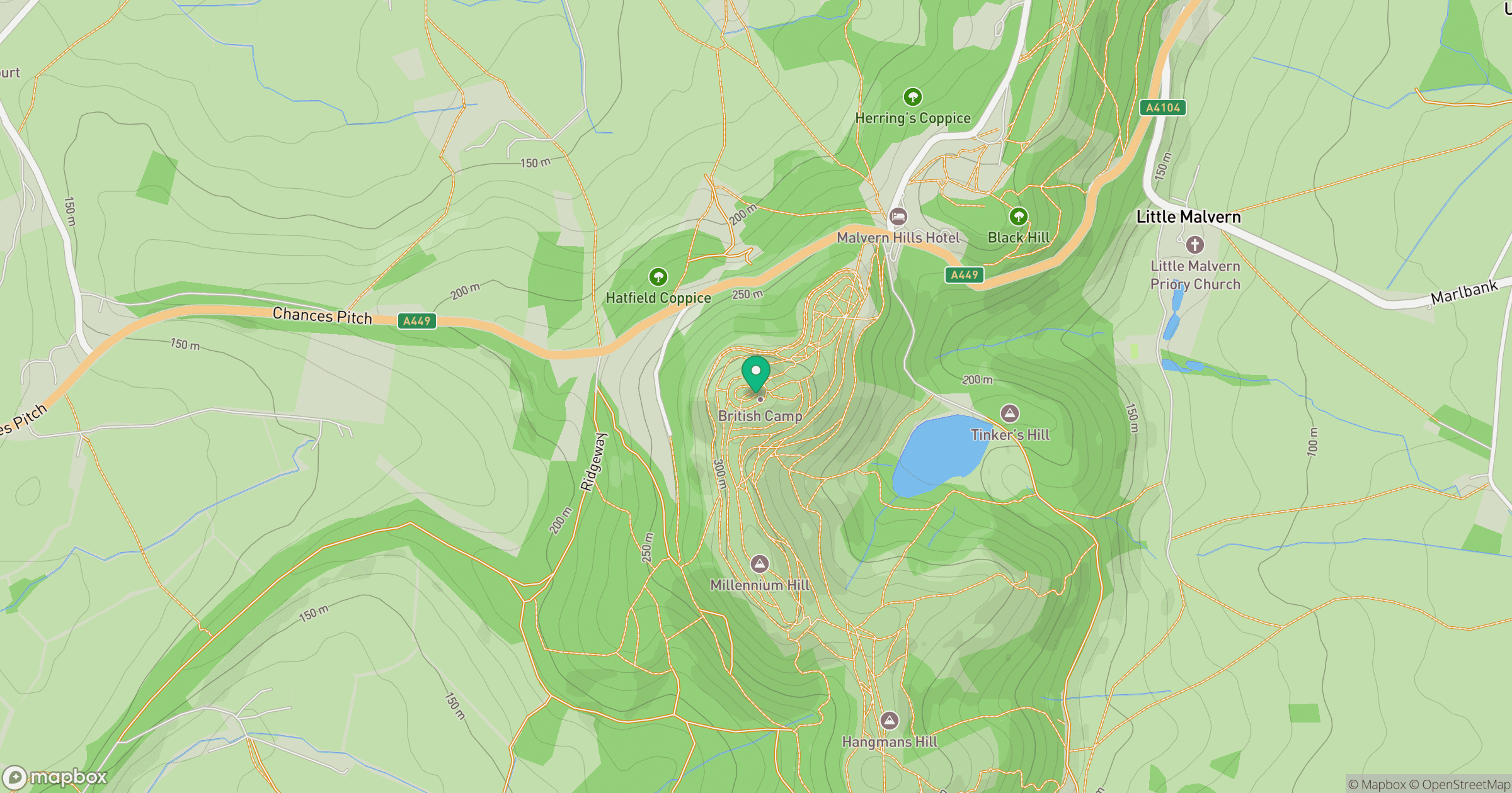
Grid reference: SO759400
View on OpenStreetMapOpens a map in a new tab, centred on the hill.
Nearby Hills
Worcestershire Beacon
425m
Titterstone Clee Hill
533m
The Wrekin
407m
Long Mynd - Pole Bank
517m
Stiperstones
537m
No comments yet. Be the first.