

Bredon Hill
Good walks are even better shared.
SO9540 : Bredon Hill from Broadway Tower
Michael Dibb Photo source
Overview
Bredon Hill is an isolated Cotswold outlier above the Vale of Evesham. Its 298.8 m natural summit lies near Kemerton Camp, an Iron Age hillfort, and Parson's Folly. Village-based circuits cross farmland, woodland and the escarpment, with wide views towards the Malverns.
Bredon Hill
Bredon Hill is an isolated Cotswold outlier above the Vale of Evesham. Its 298.8 m natural summit lies near Kemerton Camp, an Iron Age hillfort, and Parson's Folly. Village-based circuits cross farmland, woodland and the escarpment, with wide views towards the Malverns.
Summit identity
The natural summit is unmarked ground 10 m east of the boulder carrying a viewfinder, at SO 95762 40268 and 298.8 m. Parson's Folly and the Banbury Stone, also called the Elephant Stone, are nearby landmarks.
The boulder and the tower are landmarks rather than the natural high point. The route measurements below are the publishers' complete circuits through the camp and tower area; allow separately for the short visit to the exact natural summit.
Routes
Elmley Castle via Kemerton Camp and Fiddler's Knap
From Elmley Castle (SO982412), climb via Hill House Farm and bridleways to Kemerton Camp and the tower area. Return on the signed permissive path towards Lalu Farm, then the Wychavon Way and the descent beside Fiddler's Knap, returning through the village churchyard to the same starting point at SO982412. Walking Britain's complete circuit is 8.9 km, 258 m ascent and 3 h 20 min. Mud, a steeper descent and a stile occur. Visit the natural summit separately, 10 m east of the viewfinder boulder.
Kemerton via the northern edge and The Warren
Start beside St Benet's Church in Kemerton (SO949373). Climb the lane and tracks to the northern escarpment, then follow the wall to the tower area. Descend south through The Warren, follow western tracks and field-edge paths into Kemerton, then take the village road back to the starting point beside St Benet's Church. Walking Britain gives 8.5 km, 242 m ascent and 3 h 10 min for this complete circuit. Visit the natural summit separately, 10 m east of the viewfinder boulder.
Overbury via the northern edge and Overbury Park
Start and finish at Overbury Church, GL20 7NY. Climb steadily to the northern edge, follow it to the tower, then descend through Overbury Park, largely on the estate road. Evesham Ramblers gives 9.15 km and 262 m ascent for this full circuit. Its top path is narrow and rocky in places; the published route has no stiles. Keep dogs on leads. Visit the natural summit separately, 10 m east of the viewfinder boulder.
Elmley Castle, Overbury and Grafton long circuit
From Elmley Castle (SO983412), climb Hill Lane and the Wychavon Way to the camp and tower area. Descend past Sundial Farm to Overbury, continue through Grafton, then rejoin the Wychavon Way above Ashton under Hill. Return by Fiddler's Knap and the Elmley churchyard. Walking Britain gives 17.2 km, 545 m ascent and 6 h 40 min for this complete circuit, which includes substantial repeated climbing and road sections. Visit the natural summit separately, 10 m east of the viewfinder boulder.
Access, parking and facilities
For the Elmley Castle approach, Worcestershire County Council provides parking at Elmley Castle Picnic Place off Kersoe Lane, WR10 3HS, near SO982411. The council lists free admission and 24-hour pedestrian and vehicle access. The published short circuit starts nearby at SO982412. For other starts, use legal village roadside spaces without obstructing homes, gates or farm traffic. Upper Court estate parking is for its guests.
Elmley Castle Picnic Place has parking, picnic tables and an information point. Bring food and drinking water for the hill.
LMS Travel service 565 lists the Queen Elizabeth stop in Elmley Castle on its Evesham–Pershore route. Check the operator's timetable for your travel date and plan the return journey before setting out.
Use signed public footpaths and bridleways and follow current conditions on permissive paths. Keep to established routes through the archaeological earthworks and grazing land.
Terrain and safety
- Steep slopes border the northern and western escarpment; avoid shortcuts down the scarp.
- The hollow around the Banbury Stone has steep, uneven ground.
- The Elmley Castle circuit includes a muddy bridleway and a steeper descent beside Fiddler's Knap. The northern-edge path is narrow and rocky in places.
- Sheep and cattle graze parts of the hill. Keep dogs on leads near livestock and leave gates as found.
- Tracks branch across the plateau and woodland. Carry a map and identify the correct return to your starting village.
Wet weather makes muddy bridleways and sloping paths slippery; ice adds difficulty on rocky ground. The open plateau and scarp edge can be windy. In low cloud, keep away from steep edges and check junctions carefully.
Geology
Bredon Hill is a geological outlier of the Cotswolds. Jurassic clays and silts underlie the Marlstone and the Middle Jurassic Inferior Oolite limestone cap. Water passing through porous limestone meets less permeable clay, forming springs and helping destabilise slopes. Old landslips and cambering shape the escarpment. The Banbury Stone is limestone breccia: rock fragments naturally cemented together by calcite.
Views and nearby features
In clear weather the summit area overlooks the Vale of Evesham, the Severn Valley, the Malvern Hills and the Cotswold Edge.
Kemerton Camp's Iron Age earthworks, Parson's Folly, the Banbury Stone or Elephant Stone, the summit viewfinder and the northern escarpment.
Worcestershire Beacon (425.1 m) and Cleeve Hill (330 m) are other regional hill walks to plan as separate outings.
Name and history
Bredon combines an older Celtic element meaning 'hill' with Old English dun, also meaning 'hill'. The later addition of 'Hill' repeats the meaning a third time.
Kemerton Camp is an Iron Age promontory hillfort with substantial ramparts and is protected as Scheduled Monument 1005331. The hill and its views have inspired writers, artists and musicians. Parson's Folly is a familiar landmark near the natural summit.
Explore routes near Bredon Hill
Walks starting near this hill. Open a route to check its map, distance and full itinerary.
Pershore Bridges: River Avon and Tiddesley Wood circular walk
View route
Evesham Walk with Men Walking & Talking
View route
Croome: Park Seat and the river landscape
View route
Winchcombe and Belas Knap: Cotswold Way and Sudeley Valley circuit
View route
Route planning notes
These notes describe possible approaches. Check a route's map and access information when planning your walk.
Elmley Castle via Kemerton Camp and Fiddler's Knap
From Elmley Castle (SO982412), climb via Hill House Farm and bridleways to Kemerton Camp and the tower area. Return on the signed permissive path towards Lalu Farm, then the Wychavon Way and the descent beside Fiddler's Knap, returning through the village churchyard to the same starting point at SO982412. Walking Britain's complete circuit is 8.9 km, 258 m ascent and 3 h 20 min. Mud, a steeper descent and a stile occur. Visit the natural summit separately, 10 m east of the viewfinder boulder.
Kemerton via the northern edge and The Warren
Start beside St Benet's Church in Kemerton (SO949373). Climb the lane and tracks to the northern escarpment, then follow the wall to the tower area. Descend south through The Warren, follow western tracks and field-edge paths into Kemerton, then take the village road back to the starting point beside St Benet's Church. Walking Britain gives 8.5 km, 242 m ascent and 3 h 10 min for this complete circuit. Visit the natural summit separately, 10 m east of the viewfinder boulder.
Overbury via the northern edge and Overbury Park
Start and finish at Overbury Church, GL20 7NY. Climb steadily to the northern edge, follow it to the tower, then descend through Overbury Park, largely on the estate road. Evesham Ramblers gives 9.15 km and 262 m ascent for this full circuit. Its top path is narrow and rocky in places; the published route has no stiles. Keep dogs on leads. Visit the natural summit separately, 10 m east of the viewfinder boulder.
Elmley Castle, Overbury and Grafton long circuit
From Elmley Castle (SO983412), climb Hill Lane and the Wychavon Way to the camp and tower area. Descend past Sundial Farm to Overbury, continue through Grafton, then rejoin the Wychavon Way above Ashton under Hill. Return by Fiddler's Knap and the Elmley churchyard. Walking Britain gives 17.2 km, 545 m ascent and 6 h 40 min for this complete circuit, which includes substantial repeated climbing and road sections. Visit the natural summit separately, 10 m east of the viewfinder boulder.
Make a day of it, together
Find someone to share the walk with, or organise a day out along a route you like.
Photo Gallery
View all Photo could not load
SO9540 : Bredon Hill from Broadway Tower
Michael Dibb
 Photo could not load
SO9540 : Bredon Hill from Dover's Hill
Michael Dibb
 Photo could not load
SO9540 : Banbury Stone, Bredon Hill, 1950
David Hawgood
 Photo could not load
SO9540 : The Banbury Stone
Philip Halling
 Photo could not load
SO9540 : The Banbury (or Elephant) Stone
Jonathan Thacker
 Photo could not load
SO9540 : Parsons' Folly on Bredon Hill
Philip Halling
 Photo could not load
SO9540 : Stone Graffiti, Bredon Hill
Paul Buckingham
 Photo could not load
SO9540 : New Year's Day on Bredon Hill
Philip Halling
 Photo could not load
SO9540 : Cotswold Stone Wall, Bredon Hill Fort
Bob Embleton

SO9540 : The Elephant Stone prepares to sleep
Jonathan Thacker
Hill facts and local notes
Classifications
Elevation
299m
980 ft
Prominence
255m
Coordinates
52.0607, -2.0632
SO957402
OS Map
150
Explorer: 190
At the Summit
The natural summit is unmarked ground 10 m east of the boulder carrying a viewfinder, at SO 95762 40268 and 298.8 m. Parson's Folly and the Banbury Stone, also called the Elephant Stone, are nearby landmarks.
Terrain & Geology
Bredon Hill is a geological outlier of the Cotswolds. Jurassic clays and silts underlie the Marlstone and the Middle Jurassic Inferior Oolite limestone cap. Water passing through porous limestone meets less permeable clay, forming springs and helping destabilise slopes. Old landslips and cambering shape the escarpment. The Banbury Stone is limestone breccia: rock fragments naturally cemented together by calcite.
Views & Scenery
In clear weather the summit area overlooks the Vale of Evesham, the Severn Valley, the Malvern Hills and the Cotswold Edge.
History & Heritage
Name Origin
Bredon combines an older Celtic element meaning 'hill' with Old English dun, also meaning 'hill'. The later addition of 'Hill' repeats the meaning a third time.
Historical Significance
Kemerton Camp is an Iron Age promontory hillfort with substantial ramparts and is protected as Scheduled Monument 1005331. The hill and its views have inspired writers, artists and musicians. Parson's Folly is a familiar landmark near the natural summit.
Getting There & Facilities
Parking
For the Elmley Castle approach, Worcestershire County Council provides parking at Elmley Castle Picnic Place off Kersoe Lane, WR10 3HS, near SO982411. The council lists free admission and 24-hour pedestrian and vehicle access. The published short circuit starts nearby at SO982412. For other starts, use legal village roadside spaces without obstructing homes, gates or farm traffic. Upper Court estate parking is for its guests.
Public Transport
LMS Travel service 565 lists the Queen Elizabeth stop in Elmley Castle on its Evesham–Pershore route. Check the operator's timetable for your travel date and plan the return journey before setting out.
Nearby Facilities
Elmley Castle Picnic Place has parking, picnic tables and an information point. Bring food and drinking water for the hill.
Safety Information
Known Hazards
- Steep slopes border the northern and western escarpment; avoid shortcuts down the scarp.
- The hollow around the Banbury Stone has steep, uneven ground.
- The Elmley Castle circuit includes a muddy bridleway and a steeper descent beside Fiddler's Knap. The northern-edge path is narrow and rocky in places.
- Sheep and cattle graze parts of the hill. Keep dogs on leads near livestock and leave gates as found.
- Tracks branch across the plateau and woodland. Carry a map and identify the correct return to your starting village.
Seasonal Hazards
Wet weather makes muddy bridleways and sloping paths slippery; ice adds difficulty on rocky ground. The open plateau and scarp edge can be windy. In low cloud, keep away from steep edges and check junctions carefully.
General Safety Tips
- Check weather conditions before setting out
- Carry appropriate clothing and equipment
- Let someone know your planned route
- Take a map, compass, and GPS device
- Carry emergency supplies: food, water, first aid kit, torch
Hills
Some common questions about the hills answered
Are there group walks up Bredon Hill?
Many walkers use Walkmates to join or organise walks with others. You can check for group walks around Bredon Hill through the maps
Are there other walkers around Bredon Hill?
Activity varies by location and time, but Walkmates lets you see whether others have shared walks or shown interest in this area. Find other people through the walking friends search walking friends for Bredon Hill search or of course create your own walk for Bredon Hill
Can I organise a walk to Bredon Hill?
Yes. If there aren’t any walks listed already, you can create a walk and make it available for others to join.
If you're signed up to Walkmates, you can create a walk to Bredon Hill.
How do I find a walk up this hill?
There are often multiple ways to walk this hill, depending on experience and route preference. Walkmates helps you explore walks and routes that others have shared.
Can I suggest a new route up Bredon Hill?
Yes. You can suggest or create routes to share with others. Walkmates focuses on the social side of walking, so routes are used to help people organise walks and explore areas together, rather than as detailed navigation tools or route libraries.
Other uses really appreciate knowledgeable walkers sharing their routes. Share your favourite route to Bredon Hill here
The is an error or something incorrect about this hill. How do I let you know?
We always strive to keep the information on Walkmates as accurate as possible. If you find an error, please let us know through the contact form and we'll aim to correct it as quickly as possible
Community Discussion
Comments
Location
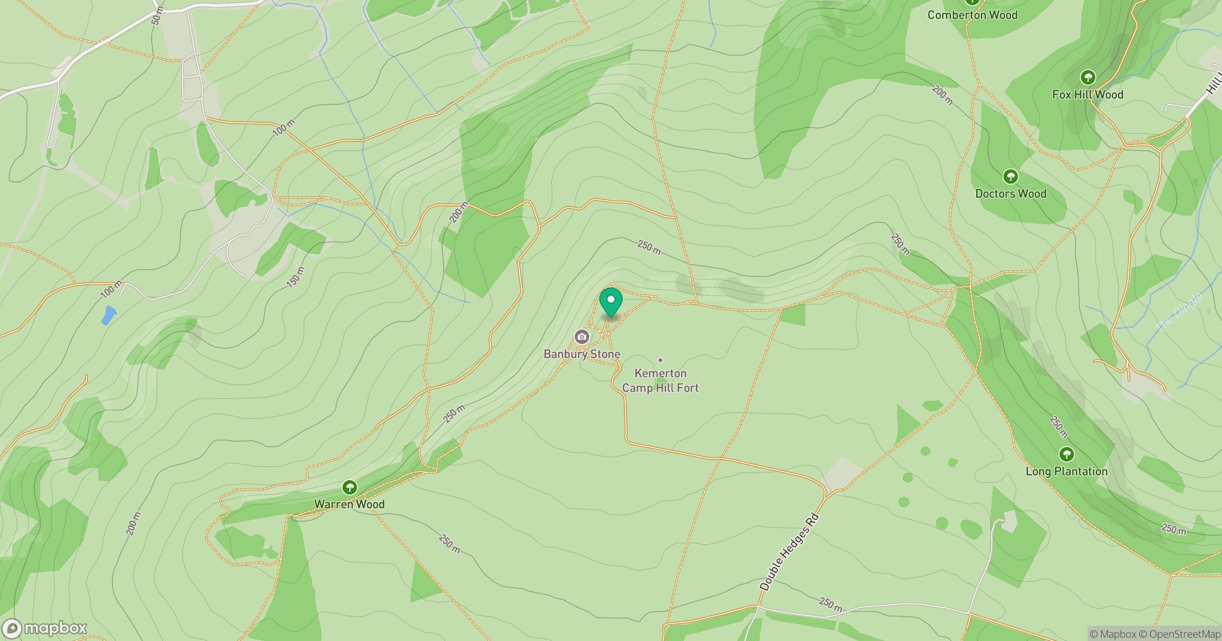
Grid reference: SO957402
View on OpenStreetMapOpens a map in a new tab, centred on the hill.
Nearby Hills
Worcestershire Beacon
425m
Titterstone Clee Hill
533m
The Wrekin
407m
Long Mynd - Pole Bank
517m
Stiperstones
537m
No comments yet. Be the first.