

Foel y Ddinas
Good walks are even better shared.
Overview
Exploring Foel y Ddinas
Foel y Ddinas rises majestically to an elevation of 466 meters in the heart of Snowdonia National Park. A Marilyn classification, it offers not just a workout for the legs, but also a feast for the eyes!
Geology
The landscape underfoot is mainly volcanic in nature, revealing a rich geological tapestry. Ancient igneous rocks testify to the region's tumultuous history, making each step feel like a walk through time – just make sure to keep your eyes on the path!
The Route
The Foel y Ddinas Circular is a popular route that embarks from Trawsfynydd. Stretching about 7.5 km, the hike takes approximately 2.5 hours, depending on how much time you spend gasping at the view!
Moderate in difficulty, this trail will take you around the hill's eastern flanks, allowing for gradual ascents peppered with stunning views. What better way to sweat out those biscuits?
Summit Features
At the summit, a rocky cairn welcomes you. Feel free to join the ranks of previous summit-goers who’ve added their stone—just don’t drop it on your foot! Enjoy a well-deserved snack and soak in the stunning surroundings—the perfect spoils of your trek.
Terrain
The paths are typically grassy with rocky outcrops scattered throughout. Keep your footing, especially after a decent rainfall, and you'll do just fine.
Views
On a clear day, the vistas from Foel y Ddinas are nothing short of breathtaking. To the north, the rugged Rhinogs loom large, while Snowdon makes a stealthy appearance to the east. Best seasons for these views are spring and autumn, when nature is at its vibrant best.
Safety Precautions
While the trail is manageable, do not underestimate the weather; it can change faster than you can say 'lovely day for a stroll.' And keep those feet dry to avoid any unwelcome slips!
Access
For those venturing out, Trawsfynydd has a parking area close to the trailhead, making it easy to lace up your boots. If you're relying on public transport, be sure to check local schedules, especially if you're planning a last-minute jaunt!
Facilities
In Trawsfynydd, facilities are minimal, but there's a shop to get the essentials. Remember the golden rule: snacks are crucial!
History
Did you know? The name Foel y Ddinas implies a historical fortress site. It wouldn't be too surprising if you stumbled upon remnants of ancient watchtowers—though I wouldn’t suggest trying to sit on them!
In conclusion, Foel y Ddinas presents a rewarding experience for hikers of moderate ability. Pack your sense of adventure and enjoy the great Welsh outdoors!
Explore routes near Foel y Ddinas
Public walks starting within 80 km of this hill. Nearby does not mean a route reaches the summit; check its map and access before setting out.
Aran Benllyn and Aran Fawddwy from LLanuwchllyn
View route
Arenig Fach guided mountain walk
View route
Waun-oer, Maesglase and Cribin Fawr guided mountain walk
View route
Coed y Brenin: Pont Ty'n-y-groes and Mawddach Forest Trail
View route
Route planning notes
These notes describe possible approaches, not verified navigable routes or permission to cross land. Check current paths, local access rules and conditions before setting out.
The Foel y Ddinas Circular
A scenic route that starts from the village of Trawsfynydd, taking you around the eastern flanks of the hill.
Make a day of it, together
Find someone to share the walk with, or organise a day out along a route you like.
Photo Gallery
View all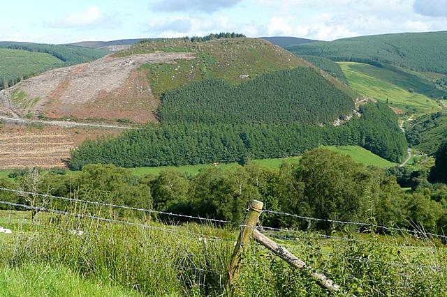 Photo could not load
SH9530 : Foel y Ddinas
Graham Horn
Hill facts and local notes
Classifications
Elevation
488m
1,601 ft
Prominence
122m
Coordinates
52.8610, -3.5575
SH952304
OS Map
125
Explorer: OL23E
At the Summit
At the summit, you'll find a well-constructed cairn and breathtaking views to reward your uphill effort. There's enough space for a picnic, if you're so inclined!
Terrain & Geology
Foel y Ddinas is primarily composed of volcanic rock, indicative of the region's dramatic geological history. The area features ancient igneous formations that date back millions of years.
Views & Scenery
From the summit, hikers can enjoy panoramic views of the surrounding Rhinogs, the expansive valleys below, and even a glimpse of the illustrious Snowdon on a clear day.
History & Heritage
Name Origin
The name 'Foel y Ddinas' translates to 'hill of the fortress,' hinting at a historical significance possibly linked to past settlements.
Historical Significance
The summit is thought to have been a lookout point due to its commanding views, suggesting early human settlement and watchful eyes toward the valleys below.
Getting There & Facilities
Check current local access restrictions, parking rules and transport timetables before travelling. These notes do not confirm public access to the summit.
Parking
There is a small parking area near Trawsfynydd, which serves as a great starting point for your adventure. It is advisable to arrive early during peak seasons due to limited spaces.
Public Transport
Buses operate from nearby towns such as Blaenau Ffestiniog to Trawsfynydd. However, service frequency may vary, so check current timetables.
Nearby Facilities
While facilities are limited in Trawsfynydd, the village does feature a small shop and raucous community centre, offering basic amenities; restrooms can be a bit sparse, so plan accordingly.
Safety Information
Known Hazards
- Be mindful of sudden changes in weather, which can be unpredictable in the area. Slippery rocks might be a challenge, especially after rain.
General Safety Tips
- Check weather conditions before setting out
- Carry appropriate clothing and equipment
- Let someone know your planned route
- Take a map, compass, and GPS device
- Carry emergency supplies: food, water, first aid kit, torch
Hills
Some common questions about the hills answered
Are there group walks up Foel y Ddinas?
Many walkers use Walkmates to join or organise walks with others. You can check for group walks around Foel y Ddinas through the maps
Are there other walkers around Foel y Ddinas?
Activity varies by location and time, but Walkmates lets you see whether others have shared walks or shown interest in this area. Find other people through the walking friends search walking friends for Foel y Ddinas search or of course create your own walk for Foel y Ddinas
Can I organise a walk to Foel y Ddinas?
Yes. If there aren’t any walks listed already, you can create a walk and make it available for others to join.
If you're signed up to Walkmates, you can create a walk to Foel y Ddinas.
How do I find a walk up this hill?
There are often multiple ways to walk this hill, depending on experience and route preference. Walkmates helps you explore walks and routes that others have shared.
Can I suggest a new route up Foel y Ddinas?
Yes. You can suggest or create routes to share with others. Walkmates focuses on the social side of walking, so routes are used to help people organise walks and explore areas together, rather than as detailed navigation tools or route libraries.
Other uses really appreciate knowledgeable walkers sharing their routes. Share your favourite route to Foel y Ddinas here
The is an error or something incorrect about this hill. How do I let you know?
We always strive to keep the information on Walkmates as accurate as possible. If you find an error, please let us know through the contact form and we'll aim to correct it as quickly as possible
Community Discussion
Comments
Location
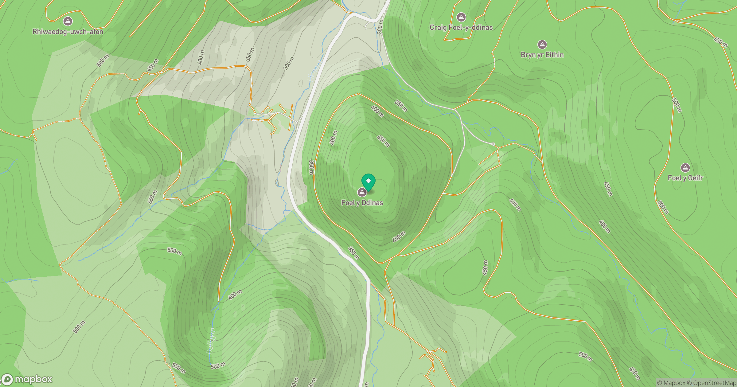
Grid reference: SH952304
View on OpenStreetMapOpens a map in a new tab, centred on the hill.
Hills within 30 km
Straight-line distance, not a walking route or confirmation of access.
No comments yet. Be the first.