
![SK1771 : Fin Cop [1]](/media/gallery/480/3d924b8c7cc143aa89088bbaf5f28c19.jpg)
Fin Cop
Good walks are even better shared.
SK1771 : Fin Cop [1]
Michael Dibb Photo source
Overview
Fin Cop
Nestled within the stunning Peak District, Fin Cop offers a delightful hiking experience with its charming landscape and rich history. With an elevation of 261 meters, this proud hill stands as a gateway to captivating scenery and striking geological formations.
Geology
Fin Cop is primarily composed of limestone, a rock known for its unique formations and biodiversity. The region's carboniferous geology contributes to its rugged beauty and offers a glimpse into the Earth’s ancient past. Hikers might find themselves admiring the exposed bedrock and understanding the significant role it plays in the local ecosystem.
Routes
One of the most popular ways to reach its summit is via the Fin Cop Circular Walk, starting from Great Longstone. This approximately 8.5 km route is well-maintained and provides hikers with a moderate challenge. Expect roughly 2.5 hours of enjoyable walking, punctuated by picturesque views and occasional encounters with fellow nature lovers.
Summit Features
Once you reach the summit, you’ll be greeted by a rocky outcrop featuring a small cairn. This delightful little heap of stones has become a well-known landmark, drawing hikers eager to take a photograph and perhaps add a stone of their own. Additionally, curious minds will appreciate the historical stone enclosures that hint at the site’s ancient significance.
Terrain
The terrain of Fin Cop is primarily grassy with rocky outcrops. While the incline is gentle, be prepared for a few muddy patches, especially after a good rain. Sturdy footwear is recommended to navigate the variances in the ground.
Views
Fin Cop promises stunning panoramic views, overlooking the Peak District's rolling hills and the breathtaking limestone cliffs of the Monsal Valley. The best views are often witnessed in spring and early summer when the vegetation is lush and vibrant. However, autumn's breathtaking colours also provide a feast for the eyes.
Hazards
Hikers should remain vigilant particularly regarding slippery rocks after rainfall. The unpredictable weather in this part of the country means that conditions can change rapidly – so be prepared!
Access
Parking is available in Great Longstone, a charming village that serves as the perfect starting point for your journey. Delightful tea shops and quaint facilities await you upon your return. The nearest town, Bakewell, is not only a culinary highlight of the region (think Bakewell pudding) but also well-served by public transport, allowing for easy access to this fantastic outdoor adventure.
Facilities
Before you embark on your trek, grab a bite at the local café in Great Longstone or ensure your comfort with the available toilets nearby. Proper planning makes for a much more enjoyable hike!
History
The name 'Fin Cop' speaks volumes about its historical significance, suggesting a boundary or end point through its etymology.
In closing, Fin Cop is not just a hike; it's an experience steeped in nature, history, and stunning landscapes. Don't forget your camera and a good sense of humour because you may need it for the inevitable sheep encounters along the way!
Happy hiking!
Explore routes near Fin Cop
Walks starting near this hill. Open a route to check its map, distance and full itinerary.
Three Villages and Five Wells
View route
Three Villages and Five Wells
View route
Three Villages and Five Wells
View route
Miller’s Dale to Bakewell guided walk
View route
Route planning notes
These notes describe possible approaches. Check a route's map and access information when planning your walk.
Fin Cop Circular Walk
A scenic circular route starting from the village of Great Longstone, offering panoramic views of the area and a gentle ascent to the summit.
Make a day of it, together
Find someone to share the walk with, or organise a day out along a route you like.
Photo Gallery
View all![SK1771 : Fin Cop [1]](https://cdn.walkmates.com/gallery-images/3d924b8c7cc143aa89088bbaf5f28c19.jpg) Photo could not load
Photo could not load
SK1771 : Fin Cop [1]
Michael Dibb
![SK1771 : Fin Cop [2]](https://cdn.walkmates.com/gallery-images/5328aaccdf6e4536b4a87a169495d681.jpg) Photo could not load
Photo could not load
SK1771 : Fin Cop [2]
Michael Dibb
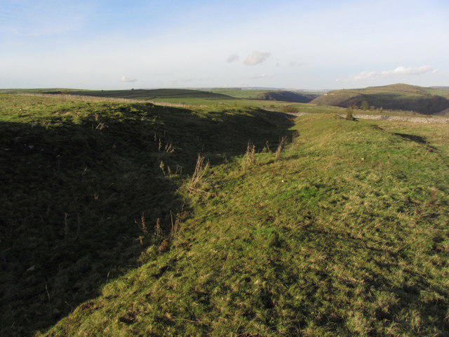 Photo could not load
SK1771 : Ditch and bank, part of Fin Cop Settlement
Colin Park
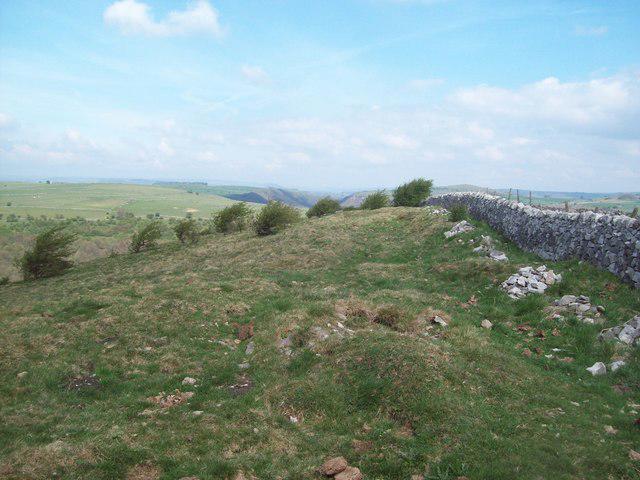 Photo could not load
SK1770 : Summit of Fin Cop
Jonathan Clitheroe
Hill facts and local notes
Classifications
Elevation
327m
1,073 ft
Prominence
96m
Coordinates
53.2352, -1.7402
SK174709
OS Map
119
Explorer: OL24E
At the Summit
The summit features a distinctive rocky outcrop, adorned with a small cairn that has become a popular landmark for hikers. The area is also known for its intriguing historical stone enclosures.
Terrain & Geology
Fin Cop is predominantly made up of limestone, which gives it its rugged features. The area is rich in carboniferous geological formations, making it a point of interest for both geologists and casual hikers alike.
Views & Scenery
From the summit, enjoy stunning views over the surrounding Peak District, including the impressive limestone cliffs of the Monsal Valley and the distant contours of the White Peak.
History & Heritage
Name Origin
The name 'Fin Cop' is derived from old words meaning 'end' or 'boundary', alluding to its position in the landscape as a notable landmark.
Historical Significance
The area is believed to have held historical significance during the Iron Age, with remnants of ancient enclosures and a historical use as a lookout point.
Getting There & Facilities
Parking
There is parking available in Great Longstone, where the circular route begins. Limited spaces can fill up quickly during weekends.
Public Transport
The nearest bus services run from Bakewell and surrounding villages to Great Longstone, with a regular schedule especially during summer.
Nearby Facilities
In Great Longstone, you’ll find a quaint café for refreshments and nearby public toilets, making it a convenient starting point for your adventure.
Safety Information
Known Hazards
- Be cautious of slippery rocks, particularly after rainfall, and be mindful of sudden weather changes common in the Peak District.
General Safety Tips
- Check weather conditions before setting out
- Carry appropriate clothing and equipment
- Let someone know your planned route
- Take a map, compass, and GPS device
- Carry emergency supplies: food, water, first aid kit, torch
Hills
Some common questions about the hills answered
Are there group walks up Fin Cop?
Many walkers use Walkmates to join or organise walks with others. You can check for group walks around Fin Cop through the maps
Are there other walkers around Fin Cop?
Activity varies by location and time, but Walkmates lets you see whether others have shared walks or shown interest in this area. Find other people through the walking friends search walking friends for Fin Cop search or of course create your own walk for Fin Cop
Can I organise a walk to Fin Cop?
Yes. If there aren’t any walks listed already, you can create a walk and make it available for others to join.
If you're signed up to Walkmates, you can create a walk to Fin Cop.
How do I find a walk up this hill?
There are often multiple ways to walk this hill, depending on experience and route preference. Walkmates helps you explore walks and routes that others have shared.
Can I suggest a new route up Fin Cop?
Yes. You can suggest or create routes to share with others. Walkmates focuses on the social side of walking, so routes are used to help people organise walks and explore areas together, rather than as detailed navigation tools or route libraries.
Other uses really appreciate knowledgeable walkers sharing their routes. Share your favourite route to Fin Cop here
The is an error or something incorrect about this hill. How do I let you know?
We always strive to keep the information on Walkmates as accurate as possible. If you find an error, please let us know through the contact form and we'll aim to correct it as quickly as possible
Community Discussion
Comments
Location
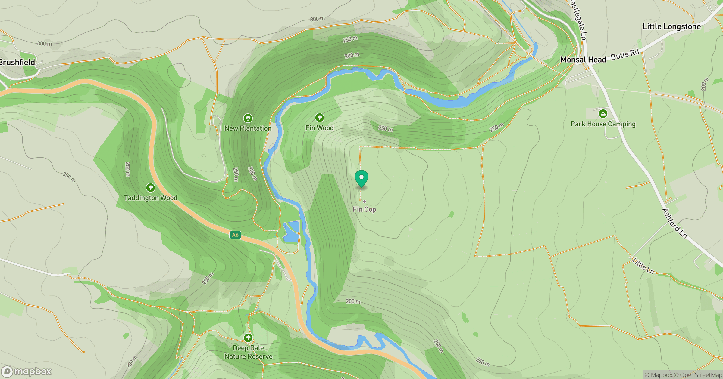
Grid reference: SK174709
View on OpenStreetMapOpens a map in a new tab, centred on the hill.
Nearby Hills

Kinder Scout
636m
The Roaches
505m
Rombalds Moor [Ilkley Moor]
402m

Pendle Hill
557m
Winter Hill
456m
No comments yet. Be the first.