

Eildon Mid Hill
Good walks are even better shared.
NT5432 : Eildon Mid Hill trig pillar
steven ruffles Photo source
Overview
Eildon Mid Hill rises to 422 m above Melrose and is the highest of the three main Eildon Hills. Its trig point and viewpoint indicator overlook the Tweed valley. Steep hill paths reach the summit from the saddle shared with Eildon Hill North; a longer circuit also visits Wester Hill.
Eildon Mid Hill
At 422 m, Eildon Mid Hill is the highest of the three main Eildons above Melrose. Eildon Hill North reaches 404 m and Eildon Wester Hill 371 m. Mid Hill is a Marilyn, with 172 m of prominence.
Walking
The Melrose approach follows St Cuthbert's Way towards the saddle, then leaves it for the steep summit path. For a Mid Hill-only walk, return by the same approach. The longer three-summit itinerary also visits Wester and North hills; its distance and time apply to that complete circuit.
The common-route notes identify each itinerary and its starting point. Nutwood and Abbey car parks serve different published walks, so match your parking to your chosen route. Check weather and carry a map, suitable footwear and weatherproof clothing.
Summit and landscape
A trig point and viewpoint indicator stand on the summit. Clear-weather views reach across the Tweed valley and surrounding Border hills. The indicator was erected in 1927 to commemorate Sir Walter Scott.
The hills expose ancient igneous intrusions: Mid Hill's summit is trachyte and its slopes include felsite. Erosion has revealed rock that originally cooled underground.
History
The prehistoric hillfort and Roman signal station occupy Eildon Hill North. The Roman fort of Trimontium lies near Newstead. These sites should not be mistaken for remains on Mid Hill itself.
Explore routes near Eildon Mid Hill
Walks starting near this hill. Open a route to check its map, distance and full itinerary.
Melrose and Gattonside Circular: Tweed and Village Views
View route
Melrose Eildon North Hill via Newstead
View route
Melrose to Newstead: River Tweed and Priorswalk
View route
Melrose to Abbotsford: River Tweed Out and Back
View route
Route planning notes
These notes describe possible approaches. Check a route's map and access information when planning your walk.
Eildon Hills three-summit circuit from Melrose
From Nutwood car park (NT548339), follow Dingleton Road and St Cuthbert's Way to the saddle. Climb Mid Hill and return to the saddle, then visit Wester Hill and return again. Cross Eildon Hill North and descend east, returning through Newstead. Walkhighlands gives 9.5 km, 525 m ascent and 3–4 hours for this complete circuit. Use the saddle route between Mid and Wester; Mid Hill's south slope is very steep.
Eildon Mid Hill from Melrose, out and back
From Nutwood car park, walk through Market Square to Dingleton Road. Take the signed St Cuthbert's Way steps and field paths to the saddle between Mid and North hills. Turn right onto the steep, stony summit path to Mid Hill's trig point and viewpoint indicator. Retrace the same approach to Melrose. This uses the summit approach of the published three-hill walk.
Make a day of it, together
Find someone to share the walk with, or organise a day out along a route you like.
Photo Gallery
View all Photo could not load
NT5432 : Eildon Mid Hill trig pillar
steven ruffles
 Photo could not load
NT5432 : Eildon Mid Hill
Raibeart MacAoidh
 Photo could not load
NT5432 : On Eildon Mid Hill
Mary and Angus Hogg
 Photo could not load
NT5432 : The Eildon Hills from Lee Pen
Jim Barton
 Photo could not load
NT5432 : Eildon Mid Hill Trig Point Flush Bracket S7474
thejackrustles
 Photo could not load
NT5432 : The Eildon Hills
David Lally
 Photo could not load
NT5432 : Misty Daybreak on Bowdenmoor Loch
Iain Lees
 Photo could not load
NT5432 : Sunrise over the Cheviots from Eildon Mid Hill
John Lindsay
 Photo could not load
NT5432 : "Good old Gala" from the Summit of Eildon Mid hill
Iain Lees

NT5432 : A winter sunrise from Eildon Mid Hill
Walter Baxter
Hill facts and local notes
Classifications
Elevation
422m
1,385 ft
Prominence
172m
Coordinates
55.5822, -2.7182
NT548322
OS Map
73
Explorer: 338
At the Summit
Trig point and viewpoint indicator on the summit. The indicator commemorates Sir Walter Scott and was erected in 1927.
Terrain & Geology
The Eildons are the eroded remains of an Early Carboniferous igneous intrusion, about 350 million years old. Magma solidified beneath the surface in sheets, rather than forming the present hills as surface lava flows. Eildon Mid Hill has trachyte at its summit and pink felsite on its steep slopes. Nearby Little Hill is a separate basaltic volcanic vent.
Views & Scenery
The Tweed valley and Melrose lie below the Eildons. In clear weather, the outlook extends towards the Lammermuir and Moorfoot Hills, Upper Tweeddale and the Cheviots.
Best Seasons
Gorse and hawthorn flower along the Melrose approach in spring; heather brings colour later in the year.
History & Heritage
Historical Significance
Mid Hill’s viewpoint indicator is a memorial to Sir Walter Scott, erected in 1927. The major prehistoric hillfort and Roman signal station are on neighbouring Eildon Hill North, not Mid Hill. These are distinct from the Roman fort of Trimontium near Newstead below the hills.
Getting There & Facilities
Parking
Nutwood car park in Melrose (NT548339) is the start of the three-summit route described here. Abbey car park on Buccleuch Street is the start of the council’s Eildon Hills Path itinerary, which differs from that circuit. Abbey is pay and display; check signs for current charges and restrictions.
Public Transport
Borders Buses services 67 and 68 connect Galashiels, Tweedbank station and Melrose. Use Melrose for the routes described here. Check current timetables and service notices, including return connections, before travelling.
Nearby Facilities
Public toilets are on Abbey Street in Melrose, near the Abbey car park. Check opening arrangements and carry food and water for the hill.
Safety Information
Known Hazards
- Steep, stony paths and loose scree require care, especially on descent.
- Mid Hill’s south slope is particularly steep; return to the saddle before continuing towards Wester Hill.
- Approach paths can be muddy after rain. Open hilltops need suitable clothing and navigation in poor weather.
General Safety Tips
- Check weather conditions before setting out
- Carry appropriate clothing and equipment
- Let someone know your planned route
- Take a map, compass, and GPS device
- Carry emergency supplies: food, water, first aid kit, torch
Hills
Some common questions about the hills answered
Are there group walks up Eildon Mid Hill?
Many walkers use Walkmates to join or organise walks with others. You can check for group walks around Eildon Mid Hill through the maps
Are there other walkers around Eildon Mid Hill?
Activity varies by location and time, but Walkmates lets you see whether others have shared walks or shown interest in this area. Find other people through the walking friends search walking friends for Eildon Mid Hill search or of course create your own walk for Eildon Mid Hill
Can I organise a walk to Eildon Mid Hill?
Yes. If there aren’t any walks listed already, you can create a walk and make it available for others to join.
If you're signed up to Walkmates, you can create a walk to Eildon Mid Hill.
How do I find a walk up this hill?
There are often multiple ways to walk this hill, depending on experience and route preference. Walkmates helps you explore walks and routes that others have shared.
Can I suggest a new route up Eildon Mid Hill?
Yes. You can suggest or create routes to share with others. Walkmates focuses on the social side of walking, so routes are used to help people organise walks and explore areas together, rather than as detailed navigation tools or route libraries.
Other uses really appreciate knowledgeable walkers sharing their routes. Share your favourite route to Eildon Mid Hill here
The is an error or something incorrect about this hill. How do I let you know?
We always strive to keep the information on Walkmates as accurate as possible. If you find an error, please let us know through the contact form and we'll aim to correct it as quickly as possible
Community Discussion
Comments
Location
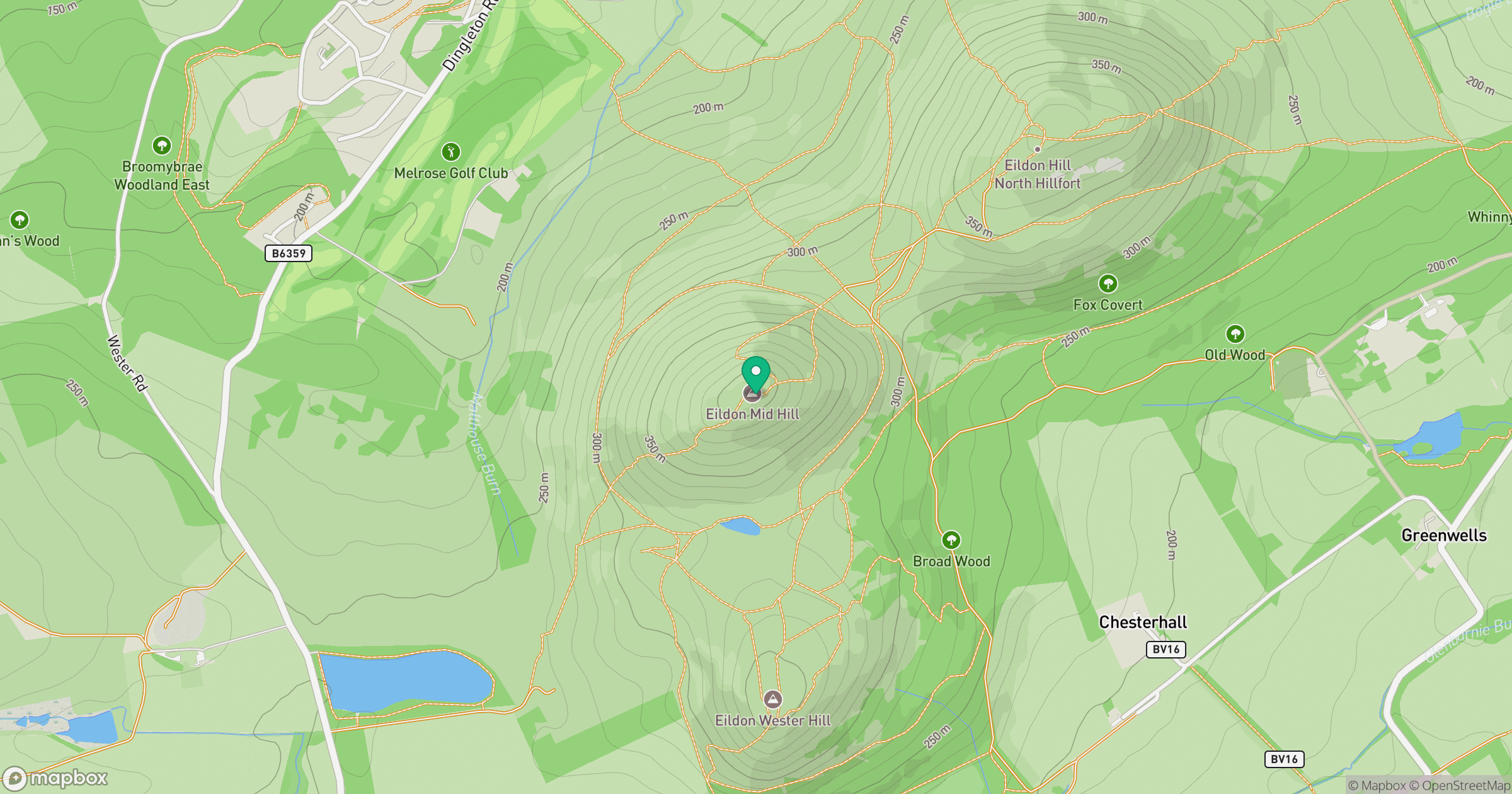
Grid reference: NT548322
View on OpenStreetMapOpens a map in a new tab, centred on the hill.
No comments yet. Be the first.