
Creag a' Chuir
Good walks are even better shared.
Overview
Creag a' Chuir
Introduction
Creag a' Chuir is a hidden gem in the Scottish Highlands, standing at a respectable elevation of 741 meters. This Corbett is often overshadowed by its grander neighbours, but trust us, it’s a trek that you won’t regret!
Geology
This mountain offers a fascinating glimpse into volcanic activity that shaped the region long ago. The volcanic rocks and sedimentary layers tell a story of earth's fiery past, and the rugged terrain is both challenging and rewarding for hikers.
The Route
Starting from the B829, the Creag a' Chuir Circuit will lead you on an approximately 7.5 km journey. Expect to spend around 3.5 hours tackling the moderate ascent. The route is well-marked, but always keep an eye on the weather - it can change faster than a cat can chase a mouse.
Summit Features
Once you've reached the summit, you’ll be greeted by a humble cairn, perfect for your well-earned rest and a selfie to prove you conquered this fine mountain!
Terrain
Be prepared for a mix of grassy areas, rocky patches, and perhaps a bog or two – it wouldn’t be the Highlands without them! A sturdy pair of boots will be your best friend.
Views
The summit provides breathtaking panoramic views of Loch Arklet and the majestic Ben Lomond, making your climb utterly worthwhile. The best time to visit is in late spring through early autumn; who wouldn’t want to enjoy those golden rays?
Hazards
Stay safe! Be aware of the unpredictable weather, rough terrain, and the fact that you might find yourself enamoured by the scenery and forgetful of time.
Nearby Summits
If you’re feeling adventurous, why not pair your hike with nearby peaks such as Ben Lomond or Meall an t-SUIDHE?
Access
Parking is limited on the B829, so ensure to park considerately. Public transport options are found in Aberfoyle, about 20 minutes by taxi to the trailhead.
Facilities
Post-hike, make your way back to Aberfoyle for some refreshing tea or a cosy café. Toilets are also available in town, which is always a bonus after a day in the great outdoors!
Conclusion
Creag a' Chuir may not be the highest or most famous mountain, but it offers a slice of the Highlands that shouldn’t be missed. So lace up your boots, pack your bag, and experience all that this spectacular landscape has to offer.
Happy hiking!
Explore routes near Creag a' Chuir
Public walks starting within 80 km of this hill. Nearby does not mean a route reaches the summit; check its map and access before setting out.
Coire Ardair lochan from Aberarder and back
View route
Fort Augustus to Kytra Lock: Caledonian Canal Towpath
View route
Great Glen Way low route: Fort Augustus to Invermoriston Old Bridge
View route
Ben Nevis via Mountain Path
View route
Route planning notes
These notes describe possible approaches, not verified navigable routes or permission to cross land. Check current paths, local access rules and conditions before setting out.
Creag a' Chuir Circuit
A scenic loop starting from the nearby B829 road, this route offers a gentle ascent with beautiful views along the way.
Make a day of it, together
Find someone to share the walk with, or organise a day out along a route you like.
Hill facts and local notes
Classifications
Elevation
643m
2,110 ft
Prominence
108m
Coordinates
56.9303, -4.4591
NN504848
OS Map
42
Explorer: OL50 393
At the Summit
The summit is crowned with a modest cairn, a perfect spot for those triumphant selfies after a good workout!
Terrain & Geology
Predominantly composed of volcanic rock with significant sedimentary layering, Creag a' Chuir showcases the stunning geological processes that shaped the Highlands. The rocky outcrops provide interesting insights into the area's ancient volcanic activity.
Views & Scenery
Panoramic views of Loch Arklet and the towering peaks of the Trossachs, including Ben Lomond. On a clear day, the beauty of the surrounding landscapes can make anyone question why they don’t live in the Highlands!
History & Heritage
Name Origin
The name 'Creag a' Chuir' translates to 'Crag of the Enclosure', which possibly refers to the ancient agricultural practices in the area.
Historical Significance
The mountain holds ecological significance, serving as a habitat for various wildlife and plants. It is a great location for nature enthusiasts.
Getting There & Facilities
Check current local access restrictions, parking rules and transport timetables before travelling. These notes do not confirm public access to the summit.
Parking
There is limited parking available on the B829, approximately 1.5 km from the trailhead. Ensure you park considerately.
Public Transport
The nearest bus stop is in the village of Aberfoyle, from which it's about a 20-minute taxi ride to the trailhead.
Nearby Facilities
Cafes and public toilets can be found in Aberfoyle, providing much-needed refreshments after your hike.
Safety Information
Known Hazards
- Variable weather conditions, uneven terrain, and remote location mean it's essential to carry appropriate gear and navigation tools.
General Safety Tips
- Check weather conditions before setting out
- Carry appropriate clothing and equipment
- Let someone know your planned route
- Take a map, compass, and GPS device
- Carry emergency supplies: food, water, first aid kit, torch
Hills
Some common questions about the hills answered
Are there group walks up Creag a' Chuir?
Many walkers use Walkmates to join or organise walks with others. You can check for group walks around Creag a' Chuir through the maps
Are there other walkers around Creag a' Chuir?
Activity varies by location and time, but Walkmates lets you see whether others have shared walks or shown interest in this area. Find other people through the walking friends search walking friends for Creag a' Chuir search or of course create your own walk for Creag a' Chuir
Can I organise a walk to Creag a' Chuir?
Yes. If there aren’t any walks listed already, you can create a walk and make it available for others to join.
If you're signed up to Walkmates, you can create a walk to Creag a' Chuir.
How do I find a walk up this hill?
There are often multiple ways to walk this hill, depending on experience and route preference. Walkmates helps you explore walks and routes that others have shared.
Can I suggest a new route up Creag a' Chuir?
Yes. You can suggest or create routes to share with others. Walkmates focuses on the social side of walking, so routes are used to help people organise walks and explore areas together, rather than as detailed navigation tools or route libraries.
Other uses really appreciate knowledgeable walkers sharing their routes. Share your favourite route to Creag a' Chuir here
The is an error or something incorrect about this hill. How do I let you know?
We always strive to keep the information on Walkmates as accurate as possible. If you find an error, please let us know through the contact form and we'll aim to correct it as quickly as possible
Community Discussion
Comments
Location
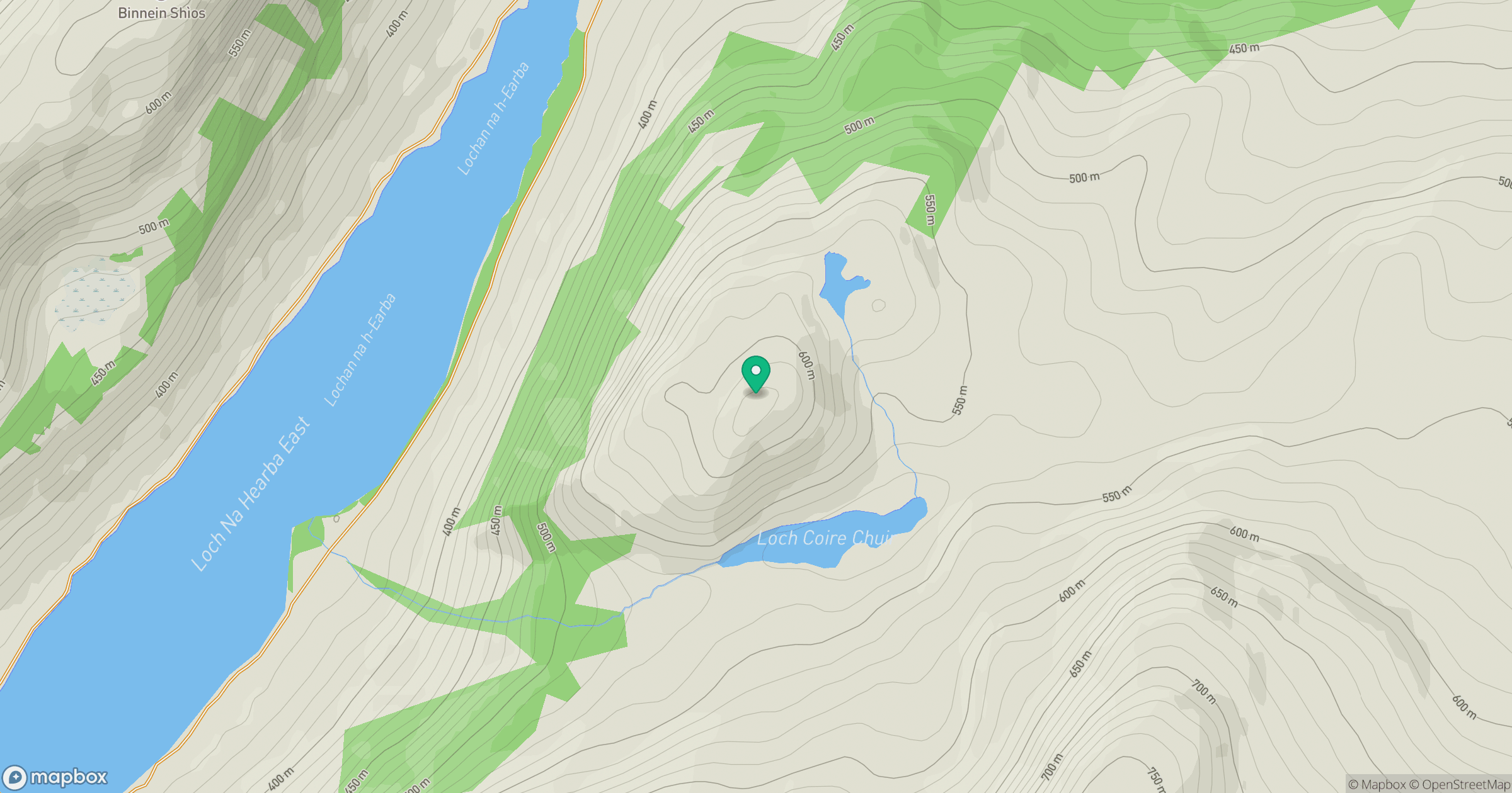
Grid reference: NN504848
View on OpenStreetMapOpens a map in a new tab, centred on the hill.
Hills within 30 km
Straight-line distance, not a walking route or confirmation of access.
No comments yet. Be the first.