

Chimney Rock Mountain
Good walks are even better shared.
Overview
Chimney Rock Mountain
Chimney Rock Mountain, standing at a respectable 411 meters, is a charming climb nestled within the breathtaking landscapes of Northumberland National Park. Known for its volcanic rock formations and robust geological features, this Marilyn offers an accessible hike with rewards that go beyond the summit.
Geology
Chimney Rock is primarily composed of ignimbrite, an unusual rock that tells tales of volcanic activity from millennia ago. As you make your way up the mountain, keep an eye out for the remnants of ancient glaciers, which shape the stunning topography of the area.
Routes
Two popular routes lead to the summit:
- Chimney Rock Trail: This circular route is perfect for families and those looking for a moderately challenging walk. It meanders around the base before climbing steadily upward over roughly 5.5 km. Allow about 2.5 hours for this jaunt, and don’t forget to enjoy the surroundings.
- The Summit Approach: If you're feeling adventurous, this direct path will take you to the summit in about an hour. At 1.2 km, it's the quickest way up but does come with a “make sure to hold onto your hat” kind of challenge!
The Summit
When you finally triumphantly reach the top, you'll be greeted by the imposing cairn and a sturdy trig point, perfect for a panoramic selfie. The views extend across the Northumberland Moors and distant Cheviot Hills, making your efforts well worth the climb!
Terrain
The best way to describe the terrain is 'grassy with a hint of rock.' While overall it's manageable, be prepared for steeper sections, particularly on the direct approach.
Views
Plan your visit for spring or early autumn to experience stunning vistas. Sunrises here are a sight to behold, with the landscape glowing as the sun breaks the horizon. Keep your eyes peeled for the iconic Hadrian's Wall winding through the hills, a true highlight for history buffs.
Hazards
Always be cautious of loose rocks, especially in wet conditions—sudden and unexpected slides can ruin your day. Proper footwear is a must!
Nearby Summits
If you're feeling up for it, why not tack on additional hikes to The Cheviot (815 m) or Carter Bar (615 m)? Both are within a short drive and offer stunning views and worthy challenges.
Access
The nearest parking area, which accommodates about 15 vehicles, fills up fast during peak season, so take a tip from the locals and get there early! Bellingham, just 10 miles away, is your best bet for public transport and local suppliers, and maybe even a good pie.
Facilities
Make sure to prep with snacks and liquid courage before your journey, as the mountain’s facilities are non-existent. But do reward yourself with a scrumptious treat at a Bellingham café when you return!
History
The quirky name of Chimney Rock comes from its very shape—a fascinating conversation starter if you bump into fellow hikers! Located near ancient sites, the mountain is a reminder of not just our natural heritage, but our cultural history as well.
So there you have it! Chimney Rock may not be the tallest, but it has a character all of its own, strutting its volcanic stuff with pride!
Explore routes near Chimney Rock Mountain
Public walks starting within 80 km of this hill. Nearby does not mean a route reaches the summit; check its map and access before setting out.
Newcastle, Co. Down (NI) with Men Walking & Talking
View route
Silent Valley to Ben Crom Dam: Reservoir Road Walk, County Down
View route
Tollymore Forest Park: River Trail near Newcastle
View route
Tollymore Forest Park: Mountain and Drinns Trail
View route
Route planning notes
These notes describe possible approaches, not verified navigable routes or permission to cross land. Check current paths, local access rules and conditions before setting out.
Chimney Rock Trail
A circular route starting from the car park that navigates around the base of the mountain before ascending to the summit. Ideal for families and less experienced hikers.
The Summit Approach
This route leads directly up to the summit via a well-defined path, providing hikers a straight shot without any faffing about.
Make a day of it, together
Find someone to share the walk with, or organise a day out along a route you like.
Photo Gallery
View all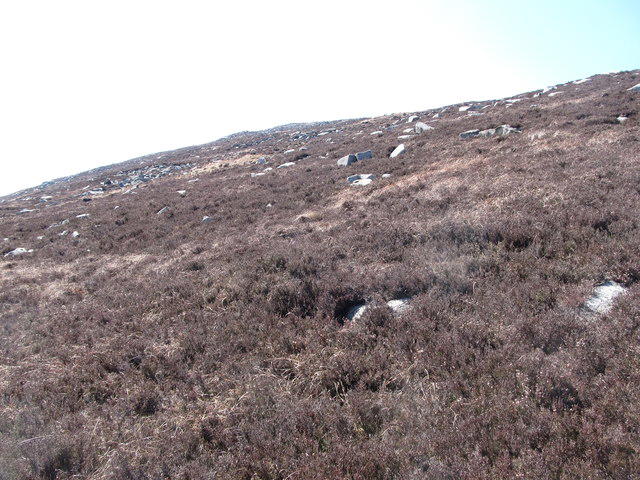 Photo could not load
J3625 : The boulder strewn eastern slopes of Chimney Rock Mountain
Eric Jones
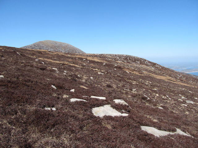 Photo could not load
J3625 : View NNW along the eastern flank of Chimney Rock Mountain
Eric Jones
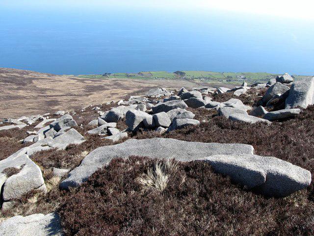 Photo could not load
J3625 : Boulders on the south-eastern slopes of Chimney Rock Mountain
Eric Jones
Hill facts and local notes
Classifications
Elevation
656m
2,152 ft
Prominence
130m
Coordinates
54.1622, -5.9125
J364257
OS Map
29
At the Summit
At the summit, you'll find a large cairn and a trig point. Stand on the trig point, and you might just feel like the king of the hill!
Terrain & Geology
Chimney Rock Mountain is primarily composed of volcanic rock, specifically ignimbrite, which gives it a robust structure. The area also showcases evidence of glacial activity and features picturesque crags that offer a glimpse into the planet's geological history.
Views & Scenery
From the summit, hikers can enjoy sweeping views of the Northumberland Moors and the distant Cheviot Hills. Keep an eye out for Hadrian's Wall peeking through the landscape.
History & Heritage
Name Origin
The name 'Chimney Rock' is thought to derive from the distinctive chimney-like shape of the rocky outcrop that looms over the landscape.
Historical Significance
Chimney Rock Mountain is part of a significant area for both natural beauty and cultural history, being located near historic sites like Hadrian's Wall, which dates back to Roman Britain.
Getting There & Facilities
Check current local access restrictions, parking rules and transport timetables before travelling. These notes do not confirm public access to the summit.
Parking
There is a parking area located at the start of the Chimney Rock Trail, with space for approximately 15 vehicles. It can get busy in the summer, so arrive early to secure a spot.
Public Transport
The nearest bus service operates from the village of Bellingham, roughly 10 miles away, offering services several times a day.
Nearby Facilities
There are no facilities directly at the mountain, but Bellingham offers cafes, pubs, and public toilets just a short drive away.
Safety Information
Known Hazards
- Loose rocks on the ascent can be treacherous. Ensure you're wearing sturdy footwear and take care, especially in wet conditions.
General Safety Tips
- Check weather conditions before setting out
- Carry appropriate clothing and equipment
- Let someone know your planned route
- Take a map, compass, and GPS device
- Carry emergency supplies: food, water, first aid kit, torch
Hills
Some common questions about the hills answered
Are there group walks up Chimney Rock Mountain?
Many walkers use Walkmates to join or organise walks with others. You can check for group walks around Chimney Rock Mountain through the maps
Are there other walkers around Chimney Rock Mountain?
Activity varies by location and time, but Walkmates lets you see whether others have shared walks or shown interest in this area. Find other people through the walking friends search walking friends for Chimney Rock Mountain search or of course create your own walk for Chimney Rock Mountain
Can I organise a walk to Chimney Rock Mountain?
Yes. If there aren’t any walks listed already, you can create a walk and make it available for others to join.
If you're signed up to Walkmates, you can create a walk to Chimney Rock Mountain.
How do I find a walk up this hill?
There are often multiple ways to walk this hill, depending on experience and route preference. Walkmates helps you explore walks and routes that others have shared.
Can I suggest a new route up Chimney Rock Mountain?
Yes. You can suggest or create routes to share with others. Walkmates focuses on the social side of walking, so routes are used to help people organise walks and explore areas together, rather than as detailed navigation tools or route libraries.
Other uses really appreciate knowledgeable walkers sharing their routes. Share your favourite route to Chimney Rock Mountain here
The is an error or something incorrect about this hill. How do I let you know?
We always strive to keep the information on Walkmates as accurate as possible. If you find an error, please let us know through the contact form and we'll aim to correct it as quickly as possible
Community Discussion
Comments
Location
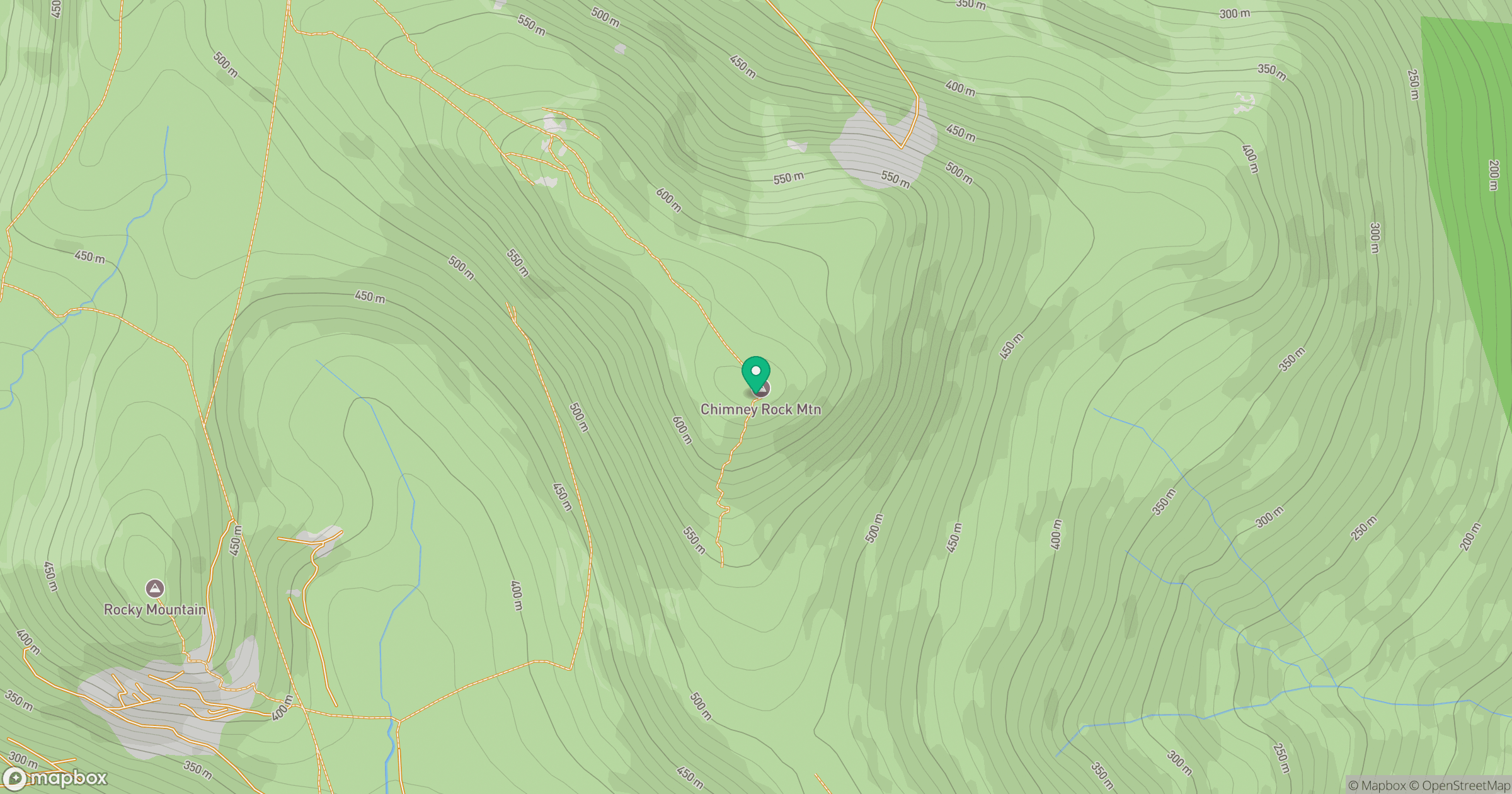
Grid reference: J364257
View on OpenStreetMapOpens a map in a new tab, centred on the hill.
Hills within 30 km
Straight-line distance, not a walking route or confirmation of access.
Slieve Donard
850m
Slieve Commedagh
767m
Slievelamagan
702m
Slieve Binnian
746m
Slieve Bearnagh
739m
No comments yet. Be the first.