
Calton Hill
Good walks are even better shared.
Overview
Calton Hill: Edinburgh's Iconic Overlook
Calton Hill rises to 106 m above Edinburgh’s east end. Its open hilltop brings together city views, volcanic rock and a distinctive group of monuments. The natural summit is the exposed rock behind Nelson Monument at NT262741, rather than the top of a building.
A returning hill walk
Start at the Calton Hill steps on Waterloo Place. Climb to Hume Walk and follow the path around the north side of the hill, then uphill towards the southern viewpoint and Nelson Monument. Visit the natural summit rock behind the tower, keeping clear of steep edges. Continue past the National Monument, then towards the Observatory and the Dugald Stewart Monument. Descend the walkway and steps beside the latter to finish at the same Waterloo Place entrance. This hill-only circuit uses surfaced paths, steps and a rougher summit approach.
Views and terrain
Look towards Edinburgh Castle and the Old Town, Arthur’s Seat and Holyrood, and across Leith towards the Firth of Forth. Pavements and surfaced park paths make much of the approach straightforward, but steps and uneven rock mean that the standard summit circuit is not step-free. The hilltop is exposed to the weather.
Geology and monuments
Calton Hill preserves Carboniferous lava flows and volcanic ash deposits associated with the Arthur’s Seat volcanic system. Faulting separated the rocks, and later ice shaped the crag-and-tail landscape. Lower western lavas include basalt; upper eastern lavas include mugearite.
The unfinished National Monument commemorates Scottish troops who died in the Napoleonic Wars. Designed by C. R. Cockerell and William Henry Playfair, its Parthenon-inspired construction ran from 1826 until funds ran out in 1829. Nelson Monument commemorates Trafalgar; the current venue account dates its construction to 1807–1815 and the addition of its time ball to 1853. The Observatory and Dugald Stewart Monument are further landmarks on the circuit.
Getting there and facilities
Waverley station is close by. Buses stop on Waterloo Place and Royal Terrace, and nearby tram stops include Picardy Place and St Andrew Square. Paid parking is available off the hill on Regent Road and at Q-Park Omni. General visitors cannot drive up to park at Collective. Its Regent Road access offers blue-badge parking during opening hours and taxi drop-off/pick-up without parking.
Collective has toilets during its opening hours, including accessible provision on request, and lists a coffee kiosk and Cafe Calton. Check the venue’s current arrangements before relying on facilities. Gallery and tower opening times do not define pedestrian access hours for the hill. Visiting Nelson Monument’s viewing platform is separate from reaching the natural summit.
Care on the hill
Use footwear with grip on uneven or slippery surfaces. Ice and snow can affect paths beyond the gallery grounds, and some areas have limited lighting after dark. Bring a light for the return from a sunset visit, watch children near rocky edges and use care at city road crossings. Follow signs around any grounds-maintenance work.
Explore routes near Calton Hill
Walks starting near this hill. Open a route to check its map, distance and full itinerary.
To Absent Friends: Holyrood Park walk
View route
Artists’ walk in Craigmillar Castle Park (group meeting)
View route
Dalkeith Country Park: Estate and North Woods Green Trail
View route
East Calder: Almondell, Mandela Bridge and River Almond Circuit
View route
Route planning notes
These notes describe possible approaches. Check a route's map and access information when planning your walk.
Calton Hill Classic Circular Walk
Start and finish at the Calton Hill steps on Waterloo Place. Climb to Hume Walk and follow it around the north side of the hill, then take the uphill path towards the southern viewpoint and Nelson Monument. The natural summit is the exposed rock behind the tower. Continue to the National Monument, then towards the Observatory and Dugald Stewart Monument. Descend the walkway and steps beside Dugald Stewart Monument to return to the same Waterloo Place entrance. Expect surfaced paths, long steps and a rougher summit approach; keep away from steep edges.
Make a day of it, together
Find someone to share the walk with, or organise a day out along a route you like.
Hill facts and local notes
Classifications
Elevation
106m
348 ft
Prominence
49m
Coordinates
55.9543, -3.1823
NT262741
OS Map
66
Explorer: 350
At the Summit
The natural summit is exposed rock behind Nelson's monument, at 106 m and NT262741. Nelson Monument, the National Monument and the Observatory are separate built landmarks around the hilltop.
Terrain & Geology
Carboniferous lava flows and volcanic ash deposits link Calton Hill to the Arthur’s Seat volcanic system. Faulting separated these rocks, and glacial erosion later shaped the crag-and-tail landform. Basalt occurs in the lower western lavas and mugearite in upper eastern lavas.
Views & Scenery
Stunning views of Edinburgh, including Arthur's Seat, the Old Town, and the Firth of Forth. On a clear day, you can even spot the Pentland Hills.
History & Heritage
Historical Significance
The National Monument commemorates Scottish troops killed in the Napoleonic Wars. C. R. Cockerell and William Henry Playfair designed the Parthenon-inspired structure; building began in 1826 and stopped in 1829 when funds ran out. Nelson Monument commemorates Trafalgar; its operator dates construction to 1807–1815 and the time ball to 1853. The City Observatory and Dugald Stewart Monument are other prominent hilltop landmarks.
Getting There & Facilities
Parking
Use paid off-hill parking on Regent Road or at Q-Park Omni. There is no general visitor parking at Collective. Blue-badge holders can use its gated Regent Road access and hilltop parking during opening hours; taxis may drop off and pick up but cannot park.
Public Transport
Waverley railway station is a short walk from the Waterloo Place approach. Lothian buses stop on Waterloo Place and Royal Terrace. Nearby tram stops are Picardy Place and St Andrew Square.
Nearby Facilities
Collective provides toilets during gallery opening hours, with accessible toilets available on request. It also lists a coffee kiosk and Cafe Calton. Check current venue hours before relying on these facilities; cafes and other services are also available in the surrounding city centre.
Safety Information
Known Hazards
- Uneven rock, steps and slippery paths need care, especially in ice or snow.
- The hilltop is exposed; check the forecast and dress for wind and rain.
- Some areas have limited lighting after dark. Bring a light for the return from a sunset visit.
- Keep clear of rocky edges and take care at busy city road crossings.
General Safety Tips
- Check weather conditions before setting out
- Carry appropriate clothing and equipment
- Let someone know your planned route
- Take a map, compass, and GPS device
- Carry emergency supplies: food, water, first aid kit, torch
Hills
Some common questions about the hills answered
Are there group walks up Calton Hill?
Many walkers use Walkmates to join or organise walks with others. You can check for group walks around Calton Hill through the maps
Are there other walkers around Calton Hill?
Activity varies by location and time, but Walkmates lets you see whether others have shared walks or shown interest in this area. Find other people through the walking friends search walking friends for Calton Hill search or of course create your own walk for Calton Hill
Can I organise a walk to Calton Hill?
Yes. If there aren’t any walks listed already, you can create a walk and make it available for others to join.
If you're signed up to Walkmates, you can create a walk to Calton Hill.
How do I find a walk up this hill?
There are often multiple ways to walk this hill, depending on experience and route preference. Walkmates helps you explore walks and routes that others have shared.
Can I suggest a new route up Calton Hill?
Yes. You can suggest or create routes to share with others. Walkmates focuses on the social side of walking, so routes are used to help people organise walks and explore areas together, rather than as detailed navigation tools or route libraries.
Other uses really appreciate knowledgeable walkers sharing their routes. Share your favourite route to Calton Hill here
The is an error or something incorrect about this hill. How do I let you know?
We always strive to keep the information on Walkmates as accurate as possible. If you find an error, please let us know through the contact form and we'll aim to correct it as quickly as possible
Community Discussion
Comments
Location
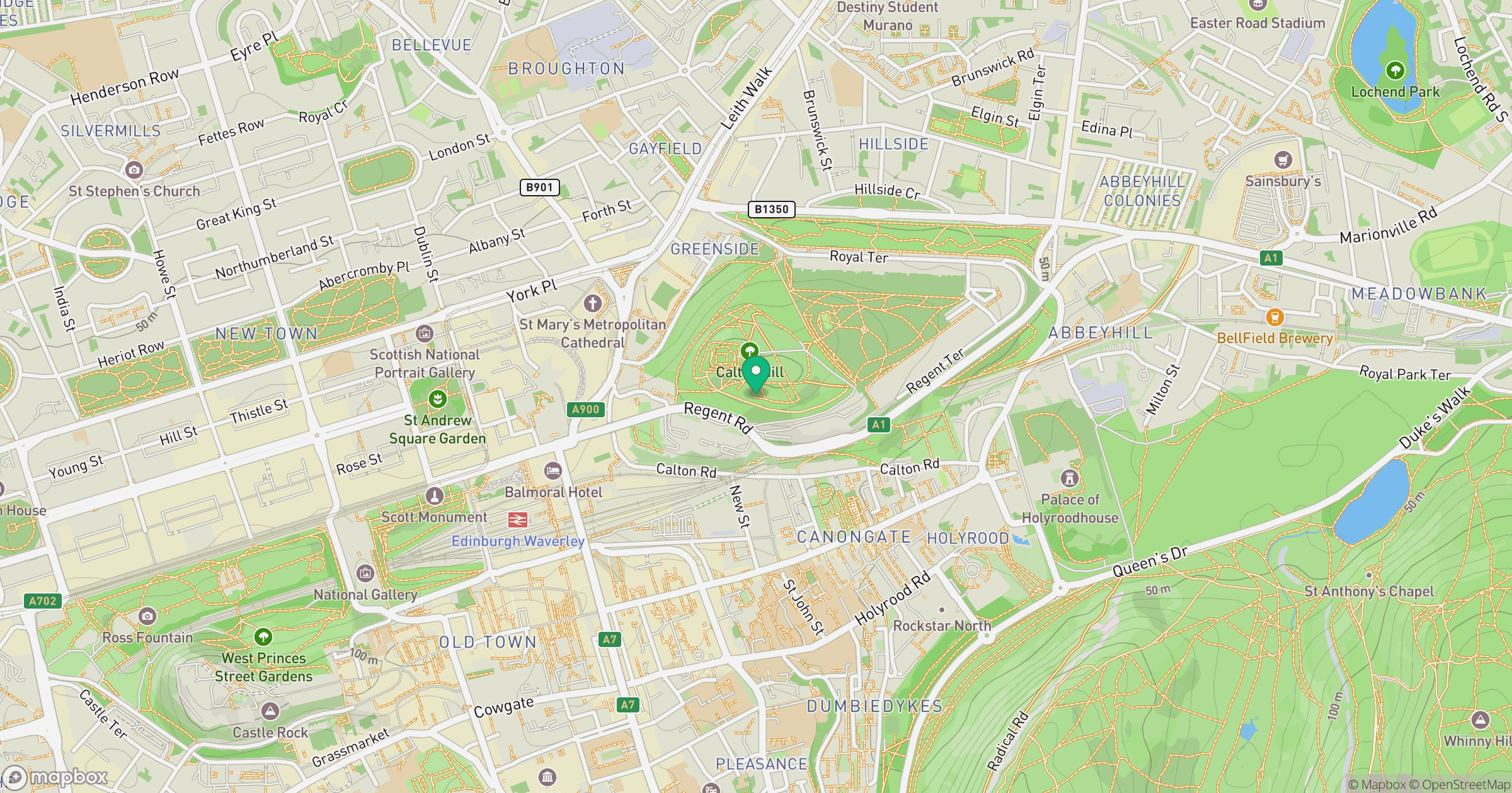
Grid reference: NT262741
View on OpenStreetMapOpens a map in a new tab, centred on the hill.
No comments yet. Be the first.