

Ben Tianavaig
Good walks are even better shared.
NG5140 : Summit of Ben Tianavaig
John Allan Photo source
Overview
Ben Tianavaig is a 413 m coastal Marilyn on Skye, above the southern side of Portree Bay. Grassy slopes lead to a trig-point summit overlooking the Sound of Raasay, while cliffs and landslip pinnacles fall away to the east. The recommended walk from Camastianavaig returns by the ascent path; the rough coastal circuit is a separate, more exposed outing.
Ben Tianavaig
Ben Tianavaig is a 413 m Marilyn on Skye, rising above the southern side of Portree Bay and the Sound of Raasay. Its summit views include Portree, Raasay, the Storr and the Cuillin in clear weather.
Summit
The highest natural ground is within 1 m of the cylindrical trig point. DoBIH gives the summit reference as NG 51182 40974, or NG511409 at six-figure precision, and a prominence of 366 m.
Landscape and geology
The eastern escarpment overlooks broken landslip ground and rock pinnacles. Geological Society of Glasgow fieldwork describes Palaeogene basalt lavas that have slipped on underlying Lower Jurassic shales below Ben Tianavaig. The grassy inland slopes contrast with the steep seaward cliffs.
Routes
Camastianavaig south ridge and return
Begin at the shore parking at Camastianavaig (NG508388). Walk along the road to the Hill Path entrance near the postbox, climb between the fences, then follow the hill path up the south ridge to the summit beside the trig. Return by the ascent route to the original shore start, using inland path alternatives where clear. Walkhighlands gives 5.5 km, 424 m of ascent and 2–3 hours for this complete out-and-back. IsleofSkye.com describes the same return scope as 5.6 km and an average two hours without breaks.
An Ceam Dubh coastal circuit
This is a separate, more demanding clockwise outing. From Tianavaig Bay, climb the south ridge to the summit, continue north and then east along the escarpment, and descend south through An Ceam Dubh below the cliffs. Drop to the coastal pasture, then follow the narrow coast path south and cross the final stony foreshore to the original bay start. Scotland Off the Beaten Track gives 7 km, 460 m of ascent and 3–3½ hours for the complete circuit. The descent has faint or absent paths and steep ground; the coastal path includes an exposed section. High tide can cover the final foreshore, so plan the tide and route before committing. The recommended easier descent is to retrace the ascent path.
Terrain and safety
Lower paths can be wet, muddy and obscured by bracken. Higher up, grassy hill paths and occasional rocky steps run beside unprotected cliffs. Keep back from the edges, use inland alternatives where clear and choose a clear day with light winds. The short distance and modest height do not remove the consequences of a fall. Keep dogs controlled around livestock and leave gates as found.
Access and facilities
Take the minor road from the B883 to Camastianavaig. Parking by the shore is limited; IsleofSkye.com describes space for around eight cars. Keep the road, passing places and private drives clear, and use the signed hill path rather than entering gardens. Picnic tables stand beside the shore. Bring food and water and use Portree for facilities before the walk; public toilets are available at Portree Pier for much of the year, with opening arrangements to check locally.
Walkhighlands mentions a bus stop at Camastianavaig road end, about 1 km from the shore start, but a current timetable has not been verified. Check a dated outward and return journey with Traveline Scotland or the operator. The route metrics above exclude any bus-stop approach.
Nearby hills
Other hills in this part of Skye include Beinn na Greine (417 m), Sithean a' Bhealaich Chumhaing (393 m) and Ben Lee (444 m). They are separate objectives with their own approaches.
Regional history
The Braes district is associated with the crofters’ land-rights struggle. The Battle of the Braes took place on 19 April 1882 following a dispute about grazing on Ben Lee. The episode became an important part of the wider movement for land reform.
Sources
Sources checked on 17 October 2026. This is the research date, separate from source publication dates and the DoBIH row revision of 2 February 2013.
- Database of British and Irish Hills, version 18.6: Ben Tianavaig, record 1230; nearby records 1229, 1232 and 1226.
- Walkhighlands: Ben Tianavaig, Braes. Article publication/update date not shown.
- IsleofSkye.com: Ben Tianavaig. Article publication/update date not shown.
- Scotland Off the Beaten Track: Ben Tianavaig. Page tagged updated 2025; stated last visit May 2022.
- Geological Society of Glasgow, Proceedings Session 160, p.22, field report from April 2018.
- High Life Highland: The Battle of the Braes.
- Scottish Outdoor Access Code.
- Portree & Braes Community Trust: Public Toilets.
Explore routes near Ben Tianavaig
Walks starting near this hill. Open a route to check its map, distance and full itinerary.
Fairy Lochs Liberator Wreckage Circuit
View route
Beinn Eighe Lancaster Wreckage at Coire Mhic Fhearchair
View route
Berneray Community Hall to the beautiful beach
View route
Glen Affric: Coire Loch Woodland Trail
View route
Route planning notes
These notes describe possible approaches. Check a route's map and access information when planning your walk.
Camastianavaig south ridge and return
Start at the shore parking at Camastianavaig (NG508388). Walk along the road to the Hill Path sign near the postbox, climb between the fences and continue up the south ridge to the summit beside the trig point. Return by the same route to the shore parking, using the inland path alternatives where clear. Allow 2–3 hours for this complete 5.5 km outing, with about 424 m of ascent. Wet lower ground and unprotected drops require care; stay back from the cliff edges. The rough coastal descent is a separate route.
An Ceam Dubh coastal circuit (rough)
From Tianavaig Bay at Camastianavaig, ascend the south ridge to Ben Tianavaig. Continue north and then east along the ridge beyond the summit before descending south through An Ceam Dubh below the cliffs. Descend to the coastal pasture, then follow the coast path south and the final stony foreshore back to the original bay start. Scotland Off the Beaten Track gives 7 km, 460 m of ascent and 3–3½ hours for this complete clockwise circuit. Faint or absent paths, very steep slopes and a narrow exposed coastal section make this substantially harder than the standard return. The final foreshore can be submerged at high tide: plan the tide and route before committing. For the easier descent, retrace the ascent path instead.
Make a day of it, together
Find someone to share the walk with, or organise a day out along a route you like.
Photo Gallery
View all Photo could not load
NG5140 : Summit of Ben Tianavaig
John Allan
 Photo could not load
NG5140 : South from the top of Ben Tianavaig
John Allan
 Photo could not load
NG5140 : Beinn Tianabhaig trig point
John Allan
 Photo could not load
NG5140 : From Ben Tianavaig to Portree
Richard Dorrell
 Photo could not load
NG5140 : Summit of Ben Tianavaig
Richard Dorrell
 Photo could not load
NG5140 : Summit of Ben Tianavaig
Richard Dorrell
 Photo could not load
NG5140 : Summit of Ben Tianavaig
John Allan
 Photo could not load
NG5140 : Ben Tianavaig Trig Point Flush Bracket 10319
thejackrustles
 Photo could not load
NG5140 : Summit of Ben Tianavaig
Richard Dorrell

NG5140 : Flush bracket 10319
Ian Taylor
Hill facts and local notes
Classifications
Elevation
413m
1,355 ft
Prominence
366m
Coordinates
57.3910, -6.1425
NG511409
OS Map
23 24
Explorer: 409 410
At the Summit
The highest natural ground is within 1 m of the cylindrical trig point, at NG 51182 40974. The summit elevation is 413 m, with 366 m of prominence. Keep back from the nearby cliff edges.
Terrain & Geology
The broken eastern slopes are a landslip landscape. Geological Society of Glasgow fieldwork describes Palaeogene basalt lavas that have slipped on underlying Lower Jurassic shales below Ben Tianavaig, leaving cliffs and pinnacles above the Sound of Raasay.
Views & Scenery
In clear weather the summit overlooks Portree and its harbour, Raasay and the Sound of Raasay, the Storr and the Trotternish coast. The Red Hills and Black Cuillin form the view to the south.
History & Heritage
Historical Significance
The surrounding Braes district is associated with the crofters’ land-rights struggle. The Battle of the Braes took place on 19 April 1882 following a dispute about grazing on Ben Lee, and became an important episode in the wider movement for land reform.
Getting There & Facilities
Parking
Limited parking beside the shore and picnic tables at Camastianavaig, reached by the minor road from the B883. IsleofSkye.com describes space for around eight cars. Keep the road, passing places and private driveways clear. The Hill Path entrance is along the road near the postbox.
Public Transport
Walkhighlands mentions a bus stop at Camastianavaig road end, about 1 km from the shore start, but a current timetable has not been verified. Check a dated outward and return journey with Traveline Scotland or the operator; do not assume a regular service from Portree. The walking-route distances exclude the bus-stop approach.
Nearby Facilities
There are picnic tables beside the shore parking. Bring food and water and use Portree for facilities before the walk. Public toilets at Portree Pier operate for much of the year; check their opening arrangements locally.
Safety Information
Known Hazards
- Unprotected cliff edges and substantial drops towards the sea occur beside the ridge paths. Keep back from the edges and avoid the route in strong winds or poor visibility.
- Wet and muddy lower paths, grassy slopes and occasional rocky steps can be slippery. Bracken can obscure parts of the lower approach.
- The optional An Ceam Dubh circuit adds steep rough ground, faint or absent paths and a narrow exposed coastal section. Its final foreshore can be submerged at high tide.
General Safety Tips
- Check weather conditions before setting out
- Carry appropriate clothing and equipment
- Let someone know your planned route
- Take a map, compass, and GPS device
- Carry emergency supplies: food, water, first aid kit, torch
Hills
Some common questions about the hills answered
Are there group walks up Ben Tianavaig?
Many walkers use Walkmates to join or organise walks with others. You can check for group walks around Ben Tianavaig through the maps
Are there other walkers around Ben Tianavaig?
Activity varies by location and time, but Walkmates lets you see whether others have shared walks or shown interest in this area. Find other people through the walking friends search walking friends for Ben Tianavaig search or of course create your own walk for Ben Tianavaig
Can I organise a walk to Ben Tianavaig?
Yes. If there aren’t any walks listed already, you can create a walk and make it available for others to join.
If you're signed up to Walkmates, you can create a walk to Ben Tianavaig.
How do I find a walk up this hill?
There are often multiple ways to walk this hill, depending on experience and route preference. Walkmates helps you explore walks and routes that others have shared.
Can I suggest a new route up Ben Tianavaig?
Yes. You can suggest or create routes to share with others. Walkmates focuses on the social side of walking, so routes are used to help people organise walks and explore areas together, rather than as detailed navigation tools or route libraries.
Other uses really appreciate knowledgeable walkers sharing their routes. Share your favourite route to Ben Tianavaig here
The is an error or something incorrect about this hill. How do I let you know?
We always strive to keep the information on Walkmates as accurate as possible. If you find an error, please let us know through the contact form and we'll aim to correct it as quickly as possible
Community Discussion
Comments
Location
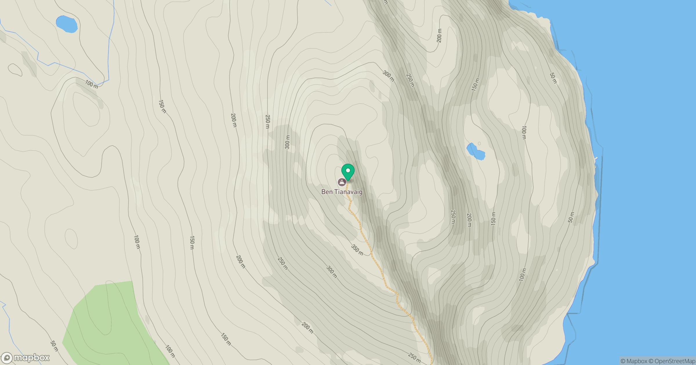
Grid reference: NG511409
View on OpenStreetMapOpens a map in a new tab, centred on the hill.
No comments yet. Be the first.