
Beinn Bhan
Good walks are even better shared.
Overview
Beinn Bhan
Beinn Bhan, standing proud at 877 meters, is not just another Munro; it's a challenging yet rewarding adventure nestled in the heart of the Scottish Highlands.
Geology
The geological features of Beinn Bhan are nothing short of fascinating. Predominantly granite, the mountain reveals ancient stories etched in stone from volcanic activity and ice ages. On a clear day, the granite sparkles, and the sharp cliffs make for dramatic drop-offs that will certainly remind you of your own mortality if you get too close.
Route Overview
The most popular route begins in the south and meanders through breathtaking glens. It's approximately 12 km long, taking about 5 hours for the average hiker. The path isn’t particularly difficult, but as with any mountain adventure, preparation is key. Proper footwear will save you from prancing awkwardly across rocky passes that might just decide to trip you up.
Summit Features
Upon reaching the summit, you’ll be greeted by a delightful stone cairn, a perfect backdrop for that triumphant selfie. Onlookers often chuckle at the sight of hikers throwing their arms up in victory after a long trek, as if to say, "Look at me! I am on top of the world!" Well, sort of.
Terrain and Views
Expect rocky paths that can turn boggy after a downpour, so watch your step. However, the effort is well worth it. When you finally hoist yourself up to the top, prepare for stunning views of the surrounding lochs and peaks.
Dramatic vistas stretching over to Loch Maree and the rugged heights of Torridon provide a visual feast; just keep an eye out for the odd sheep that might be plotting to steal your lunch.
Hazards
Be aware that the terrain can be challenging. Mishaps can happen if you let your guard down, especially with sudden weather changes. Carry the necessary gear and a map; a good explorer never goes into the wild unprepared!
Access and Facilities
Parking is available near the main trailhead, about 10 minutes from the lovely village of Kinlochewe, which serves as your gateway to adventure. If you're relying on public transport, buses run regularly from Inverness, dropping you right at the village.
Kinlochewe isn't just a place to park; it's where your adventure begins. With a local café dishing up hearty meals and shops that won't judge your choice of £5 chocolate bars for sustenance, you’re well-stocked for your hike.
History
In Gaelic, Beinn Bhan means 'White Mountain.' The lighter granite that gleams in the sun is a nod to the mountain's name, and it has historical importance with nearby ancient settlements adding to its allure.
After a good day outdoors, a round at the café with tales of adventure is often on the cards, preferably with a side of cake. So lace up those boots, grab your walking pole, and head out to one of Scotland’s hidden gems!
Explore routes near Beinn Bhan
Walks starting near this hill. Open a route to check its map, distance and full itinerary.
Beinn Eighe Lancaster Wreckage at Coire Mhic Fhearchair
View route
Fairy Lochs Liberator Wreckage Circuit
View route
Glen Affric: Coire Loch Woodland Trail
View route
Fort Augustus to Kytra Lock: Caledonian Canal Towpath
View route
Route planning notes
These notes describe possible approaches. Check a route's map and access information when planning your walk.
Main Route from the South
A popular route that winds through scenic glens and offers stunning vistas along the ascent, making it a favourite among hikers needing a bit of motivation.
Make a day of it, together
Find someone to share the walk with, or organise a day out along a route you like.
Hill facts and local notes
Classifications
Elevation
896m
2,939 ft
Prominence
851m
Coordinates
57.4424, -5.6617
NG803450
OS Map
24
Explorer: 428N 428S
At the Summit
The summit is marked by a stone cairn, a popular spot for weary hikers to take a celebratory selfie with their accomplishment.
Terrain & Geology
Composed predominantly of granite, Beinn Bhan's rugged structure features dramatic cliffs and steep slopes, shaped by ancient glacial activity. The rock formations here tell tales of the earth’s history, from volcanic origins to serene valleys.
Views & Scenery
From the summit, one can enjoy breathtaking views of the rugged terrain of the Highlands, including the nearby Loch Maree and the peaks of Torridon.
History & Heritage
Name Origin
Beinn Bhan translates to 'White Mountain' in Gaelic, likely referring to its lighter-coloured granite rock which appears striking against the backdrop of the blue skies.
Historical Significance
This area has historic significance, with evidence of ancient settlements nearby, and it holds a vital place in the folklore of the Highlands.
Getting There & Facilities
Parking
There is a small parking area near the start of the main route, approximately a 10-minute drive from the village of Kinlochewe.
Public Transport
Buses from Inverness to Kinlochewe operate regularly, stopping at the village, which is the closest point of public transport access.
Nearby Facilities
Facilities include a café in Kinlochewe, offering refreshments and bathroom facilities for hikers. There are also a couple of small shops for supplies.
Safety Information
Known Hazards
- Uneven terrain can lead to falls; sudden weather changes may result in visibility problems. Ensure to pack extra layers and check the forecast before setting out.
General Safety Tips
- Check weather conditions before setting out
- Carry appropriate clothing and equipment
- Let someone know your planned route
- Take a map, compass, and GPS device
- Carry emergency supplies: food, water, first aid kit, torch
Hills
Some common questions about the hills answered
Are there group walks up Beinn Bhan?
Many walkers use Walkmates to join or organise walks with others. You can check for group walks around Beinn Bhan through the maps
Are there other walkers around Beinn Bhan?
Activity varies by location and time, but Walkmates lets you see whether others have shared walks or shown interest in this area. Find other people through the walking friends search walking friends for Beinn Bhan search or of course create your own walk for Beinn Bhan
Can I organise a walk to Beinn Bhan?
Yes. If there aren’t any walks listed already, you can create a walk and make it available for others to join.
If you're signed up to Walkmates, you can create a walk to Beinn Bhan.
How do I find a walk up this hill?
There are often multiple ways to walk this hill, depending on experience and route preference. Walkmates helps you explore walks and routes that others have shared.
Can I suggest a new route up Beinn Bhan?
Yes. You can suggest or create routes to share with others. Walkmates focuses on the social side of walking, so routes are used to help people organise walks and explore areas together, rather than as detailed navigation tools or route libraries.
Other uses really appreciate knowledgeable walkers sharing their routes. Share your favourite route to Beinn Bhan here
The is an error or something incorrect about this hill. How do I let you know?
We always strive to keep the information on Walkmates as accurate as possible. If you find an error, please let us know through the contact form and we'll aim to correct it as quickly as possible
Community Discussion
Comments
Location
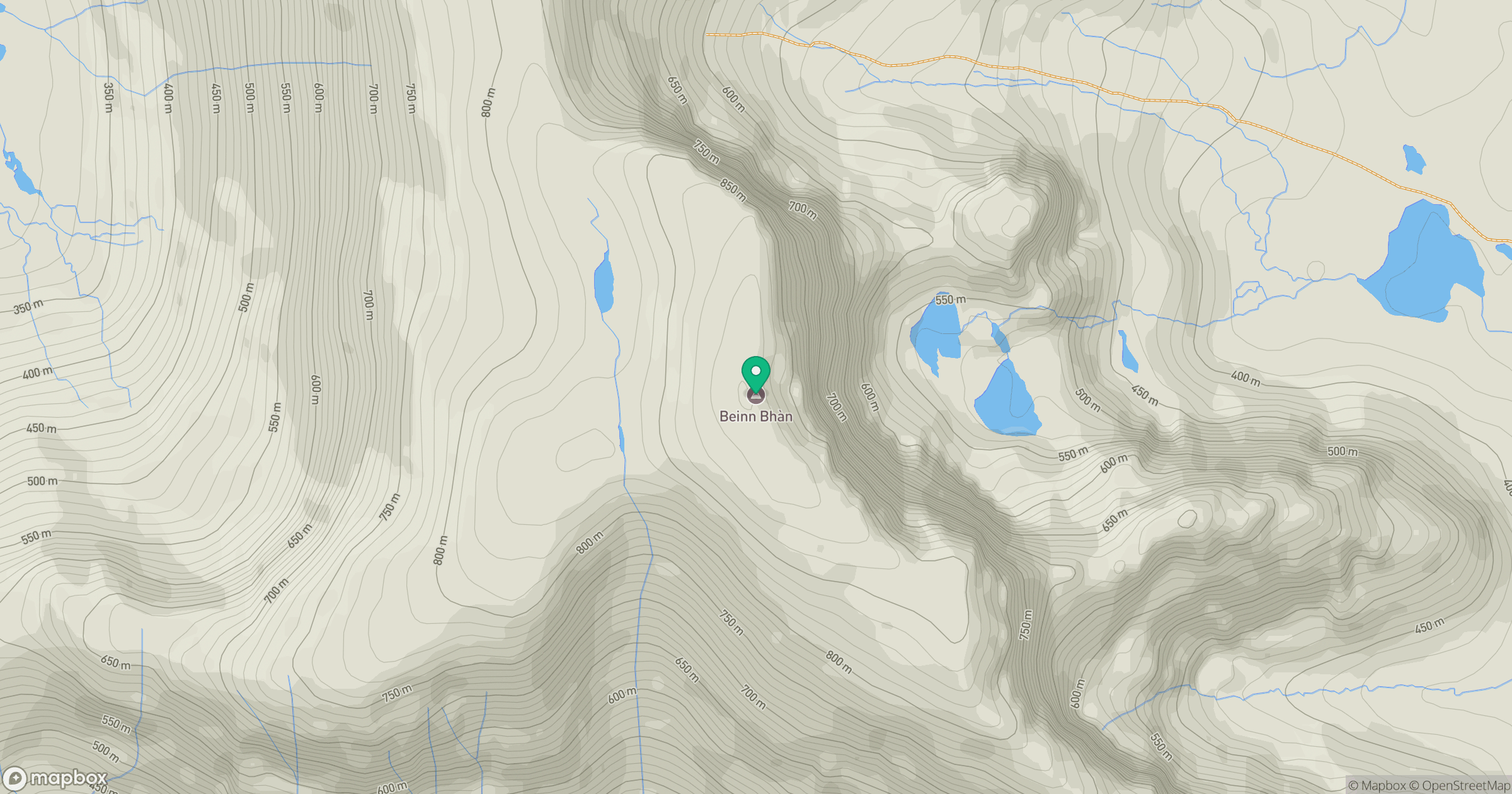
Grid reference: NG803450
View on OpenStreetMapOpens a map in a new tab, centred on the hill.
No comments yet. Be the first.