

Liathach - Spidean a' Choire Leith
Good walks are even better shared.
NG9358 : Liathach, Torridon.
djmacpherson Photo source
Overview
Spidean a' Choire Leith (1,054.8 m) is Liathach's highest summit above Glen Torridon. A summit-only eastern ascent is distinct from the full two-Munro traverse across Am Fasarinen to Mullach an Rathain. Very steep terrain, scrambling and exposed ground require experienced mountain judgement and navigation.
Liathach - Spidean a' Choire Leith
Spidean a' Choire Leith is Liathach's highest summit in Torridon. Its recorded height is 1,054.8 m (commonly rounded to 1,055 m); it is a Munro and Marilyn. This page describes that summit, which is distinct from Liathach's western Munro, Mullach an Rathain (1,023.9 m). DoBIH
Terrain and geology
Torridonian sandstone forms Liathach's terraced cliffs, with quartzite covering the highest summit. The previous description of a predominantly schist-and-gneiss mountain was incorrect. BGS; Torridon Mountain Rescue
The summit is a rough, angular quartzite cone with a cairn. Its ridge overlooks the northern corries and the rest of Liathach. Steep slopes and concealed cliffs make precise navigation important. Summit guide; Chris Townsend
Choosing a route
Summit-only eastern approach: approach from Glen Torridon via Toll a' Meitheach and the eastern ridge, then retrace that route. This avoids the main Am Fasarinen traverse but still involves steep mountain paths, some scrambling and rough boulders. It is a demanding mountain outing rather than a moderate walk. Chris Townsend; standalone out-and-back description
Full ridge traverse: this also visits Mullach an Rathain. The standard eastern start is the A896 parking east of Glen Cottage, NG935566; the usual western descent is through Toll Ban to a different roadhead. Walkhighlands quotes 11.5 km and 8–10 hours for its published route. Those figures belong to that itinerary: confirm the chosen parking, variations and return arrangements before using them. Full route
Taking the Am Fasarinen pinnacles directly normally involves Grade 2 scrambling in summer conditions. The narrow southern bypass remains severely exposed above cliffs and can be eroded or wet. Neither option should be presented as easy. West-to-east is also possible, but does not remove the need for competent route-finding; a South Ridge ascent is a separate variation. UKHillwalking; Climb Torridon
Northern Pinnacles: these concern Meall Dearg and Mullach an Rathain. They are a specialist, technical addition, not a direct ordinary approach to Spidean. Go Further Scotland
Coire na Caime: the former moderate circular itinerary and its 10 km/4 h figures have not been verified and should not be used. The separate published walk behind Liathach is a linear through-walk with different roadheads; it is not evidence for the former circuit. Behind Liathach guide
These summaries are for planning, not turn-by-turn navigation. Use a complete current route guide and suitable mapping. Do not improvise descents through Liathach's terraced cliffs. If the party lacks the required experience, seek qualified local guidance.
Weather and winter
Wet rock, wind and cloud increase the seriousness of exposed terrain. Snow and ice require winter mountaineering competence, suitable boots, ice axe and crampons, and the skills to use them. Assess avalanche conditions and cornices; summer routes and grades do not describe winter conditions. Check mountain weather and the seasonal SAIS Torridon forecast alongside Mountaineering Scotland's winter guidance. An archived forecast is not a current assessment.
Access and facilities
Parking near the eastern path is limited. Use legitimate spaces and keep passing places clear. The published standard guide lists no public transport to the start; arrange the final journey and the return between roadheads rather than assuming a direct city bus or nearby Tornapress stop. Route access; NTS visitor information
Torridon village has a shop/café and public toilets, and Torridon Youth Hostel provides accommodation. Check opening and booking arrangements directly. NTS facilities; Hostelling Scotland
Name
Liathach is commonly translated as 'the grey one'; Spidean a' Choire Leith as 'peak of the grey corrie'. These names appear in the historical Scottish Mountaineering Club Journal. The earlier unsourced folklore and best-season claims have been removed.
Source and scope note
Content checked on 15 October 2026 against independent geological, mountaineering, land-manager and route sources. The original DoBIH-derived summit measurements and source revision are retained. Source-coordinate variants are recorded in the catalogue comments; this is an editorial audit, not a new survey. Route summaries do not certify current ground conditions or separately linked tracks.
Explore routes near Liathach - Spidean a' Choire Leith
Walks starting near this hill. Open a route to check its map, distance and full itinerary.
Beinn Eighe Lancaster Wreckage at Coire Mhic Fhearchair
View route
Fairy Lochs Liberator Wreckage Circuit
View route
Loch Affric full circuit from River Affric
View route
Glen Affric: Coire Loch Woodland Trail
View route
Route planning notes
These notes describe possible approaches. Check a route's map and access information when planning your walk.
Liathach Traverse (East to West)
Start from the A896 east of Glen Cottage (NG935566). The standard traverse reaches Spidean a' Choire Leith via Toll a' Meitheach and the eastern ridge, then crosses Am Fasarinen to Mullach an Rathain. The pinnacles involve exposed Grade 2 scrambling; the southern bypass is also very exposed. The usual descent via Toll Ban reaches a different roadhead. Plan the return and use a full current guide; this is a planning summary.
Spidean a' Choire Leith (Eastern Approach, Out and Back)
A summit-only ascent from the A896 east of Glen Cottage, via Toll a' Meitheach and the eastern ridge, returning by the same route. It stops at Spidean a' Choire Leith and does not cross Am Fasarinen or reach Mullach an Rathain. Very steep paths, short scrambling sections and rough quartzite remain demanding, particularly on descent or in cloud. This is not a moderate low-exposure walk. Use a detailed guide and map.
Liathach Traverse (West to East)
A reverse traverse visits Mullach an Rathain before crossing Am Fasarinen to Spidean a' Choire Leith and the eastern ridge. Specify the western ascent, eastern descent and road return using a full guide; the South Ridge is a separate scrambling variant. The pinnacles and exposed southern bypass retain their seriousness in either direction. There is no sound basis for calling west-to-east navigation easier. No complete itinerary is supplied here.
Specialist Northern Pinnacles: Not a Direct Spidean Approach
The Northern Pinnacles link Meall Dearg with Mullach an Rathain, not directly with Spidean a' Choire Leith. This is specialist exposed scrambling and rock-climbing terrain, distinct from Am Fasarinen. Continuing to Spidean requires a separately planned main-ridge traverse. The former Glen Cottage/Coire na Caime directions and 8 km/6 h totals are withdrawn. Consult a specialist guide; this correction note is not a navigable itinerary.
Unverified Coire na Caime Circuit: Planning Note Only
The former 10 km/4 h moderate circuit from Glen Cottage has not been substantiated and its directions and totals are withdrawn. Coire na Caime lies on Liathach's northern side; this card does not establish a safe circuit or a summit route. Do not navigate from it. A separately published Coire Dubh/Coire Mhic Nobuil through-walk has different roadheads and must be planned from its own guide.
Make a day of it, together
Find someone to share the walk with, or organise a day out along a route you like.
Photo Gallery
View all Photo could not load
NG9358 : Liathach, Torridon.
djmacpherson
 Photo could not load
NG9257 : Spidean a' Choire Leith from the end of Am Fasarinen
Nigel Brown
 Photo could not load
NG9258 : View north from Spidean a' Choire Lèith
Russel Wills
 Photo could not load
NG9258 : Looking down Coire Mhic Nòbuil
Nigel Brown
 Photo could not load
NG9358 : Winter conditions on Liathach
Walter Baxter
 Photo could not load
NG9358 : Walking on Liathach
Walter Baxter
 Photo could not load
NG9258 : Loch Clair with Liathach & Beinn Eighe
djmacpherson
 Photo could not load
NG9258 : Liathach from Beinn Alligin with Brocken Spectre
ronnie leask
 Photo could not load
NG9258 : Liathach
Ivor MacKenzie

NG9258 : Liathach in deep snow
Andrew Spenceley
Hill facts and local notes
Classifications
Elevation
1,055m
3,461 ft
Prominence
957m
Coordinates
57.5642, -5.4636
NG929579
OS Map
25
Explorer: 433
At the Summit
Cairn on the rocky, quartzite-covered highest summit of Liathach.
Terrain & Geology
Liathach's terraced cliffs are chiefly Torridonian sandstone. Quartzite caps the highest summit, Spidean a' Choire Leith, forming its angular rocky cone.
Views & Scenery
Views along Liathach to Am Fasarinen and Mullach an Rathain, into the northern corries and across the Torridon mountains. Visibility depends on cloud and weather.
History & Heritage
Name Origin
Liathach is commonly translated as 'the grey one'. Spidean a' Choire Leith is commonly rendered 'peak of the grey corrie'.
Historical Significance
Liathach and its named summits were described in the Scottish Mountaineering Club Journal in the early twentieth century. The earlier generic folklore claim was not substantiated.
Getting There & Facilities
Parking
The standard eastern approach starts at limited A896 roadside parking east of Glen Cottage, grid reference NG935566. The usual full traverse descends to a different roadhead near the Toll Ban path; plan how to return. Use legitimate parking spaces and do not obstruct single-track passing places. Check local notices and space on arrival.
Public Transport
The published standard traverse guide lists no public transport to its start east of Glen Cottage. Check current services to Torridon and arrange onward travel to the A896 trailheads and the return journey. Do not assume a direct bus from Edinburgh or Glasgow serves the walk.
Nearby Facilities
Torridon village has a shop/café and public toilets; Torridon Youth Hostel offers accommodation. Check current opening and booking arrangements directly. These village facilities are separate from the roadside mountain-path starts.
Safety Information
Known Hazards
- Very steep terrain, loose rock, boulders and cliff edges require care even on a summit-only ascent.
- The direct Am Fasarinen pinnacles involve exposed Grade 2 scrambling in summer conditions.
- The southern bypass is narrow, eroded in places and very exposed above cliffs; it is not an easy option.
- Cloud and poor visibility complicate route-finding. Terraced cliffs can be hidden from above; do not improvise descent shortcuts.
- Strong wind, wet rock and fatigue increase risk. Plan a complete route and return arrangements before setting out.
- Northern Pinnacles are separate specialist terrain associated with Meall Dearg and Mullach an Rathain.
Seasonal Hazards
Snow and ice make both summit-only ascents and ridge traverses serious winter mountaineering. Winter navigation, avalanche awareness, suitable boots, ice axe and crampons, and the skills to use them are needed. Beware cornices and check mountain weather and the seasonal SAIS Torridon forecast; archived reports do not show current conditions.
General Safety Tips
- Check weather conditions before setting out
- Carry appropriate clothing and equipment
- Let someone know your planned route
- Take a map, compass, and GPS device
- Carry emergency supplies: food, water, first aid kit, torch
Hills
Some common questions about the hills answered
Are there group walks up Liathach - Spidean a' Choire Leith?
Many walkers use Walkmates to join or organise walks with others. You can check for group walks around Liathach - Spidean a' Choire Leith through the maps
Are there other walkers around Liathach - Spidean a' Choire Leith?
Activity varies by location and time, but Walkmates lets you see whether others have shared walks or shown interest in this area. Find other people through the walking friends search walking friends for Liathach - Spidean a' Choire Leith search or of course create your own walk for Liathach - Spidean a' Choire Leith
Can I organise a walk to Liathach - Spidean a' Choire Leith?
Yes. If there aren’t any walks listed already, you can create a walk and make it available for others to join.
If you're signed up to Walkmates, you can create a walk to Liathach - Spidean a' Choire Leith.
How do I find a walk up this hill?
There are often multiple ways to walk this hill, depending on experience and route preference. Walkmates helps you explore walks and routes that others have shared.
Can I suggest a new route up Liathach - Spidean a' Choire Leith?
Yes. You can suggest or create routes to share with others. Walkmates focuses on the social side of walking, so routes are used to help people organise walks and explore areas together, rather than as detailed navigation tools or route libraries.
Other uses really appreciate knowledgeable walkers sharing their routes. Share your favourite route to Liathach - Spidean a' Choire Leith here
The is an error or something incorrect about this hill. How do I let you know?
We always strive to keep the information on Walkmates as accurate as possible. If you find an error, please let us know through the contact form and we'll aim to correct it as quickly as possible
Community Discussion
Comments
Location
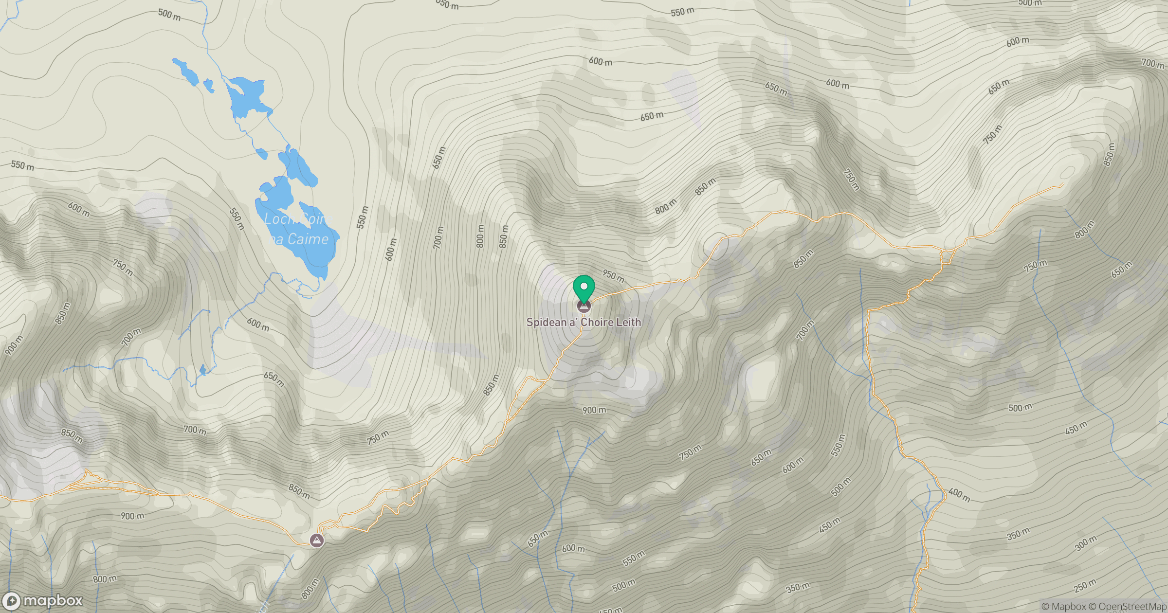
Grid reference: NG929579
View on OpenStreetMapOpens a map in a new tab, centred on the hill.
No comments yet. Be the first.