
A' Chruach
Good walks are even better shared.
Overview
A' Chruach: A Gem in the Highlands
Nestled in the heart of the Scottish Highlands, A' Chruach stands proudly at an elevation of 740 meters. Known for its rugged beauty and panoramic views, this Marilyn offers an inviting challenge for both novice and seasoned hikers alike.
Geology
The mountain is primarily made of schist and granite, showcasing the incredible geological history of the Scottish Highlands. Glacial features evident throughout the landscape tell tales of ancient times when glaciers carved out these magnificent hills.
Hiking Routes
One of the most popular routes to the summit begins at Glen Dochart. This moderately challenging trek spans 7.5 km and typically takes about 3.5 hours. It traverses lush landscapes, rocky outcrops, and offers numerous photo opportunities along the way.
Summit Features
Upon reaching the summit, hikers are greeted by a prominent cairn marking the peak – the perfect spot to catch your breath and snap that all-important selfie. Just be careful not to trip over the very stones that define this beauty!
Terrain
The terrain is rugged and rocky, with grassy patches and sprawling heather adding to the enchanting atmosphere. Good footwear is essential to tackle the uneven paths leading to the top.
Views
The views from A' Chruach are truly captivating. On a clear day, you can see Loch Tay stretching out to the southeast and the dramatic peaks of Ben More to the northwest. Spring and autumn are particularly magical times to hike, as the changing colours of nature add an extra dash of vibrance to the already stunning vista.
Hazards
As with any mountainous terrain, caution is advised. The steep and uneven ground can pose slip hazards, especially in wetter conditions. Also, keep an eye on the weather; mist can roll in fast, which can reduce visibility significantly.
Access
For accessing A' Chruach, you can park at a small area on the edge of Glen Dochart. Public transport seekers can find the nearest train station in Crianlarich, approximately 10 miles away, with bus services connecting to Killin.
Facilities
While facilities are sparse on the mountain itself, the nearby village of Killin offers a range of options, including cafes and public toilets, making it a great starting point for your adventure.
History and Meaning
The name 'A' Chruach' or 'The Stony Hill' gives a nod to its geological features. Recognized for its scenic beauty and hiking opportunities, this mountain has held significant importance for local outdoor enthusiasts for ages.
Whether you're an experienced mountaineer or someone just keen to explore, A' Chruach is well worth the visit. Just remember to bring a map, some snacks, and perhaps a flask of tea – you’ll want to relish every moment on this splendid hill!
Explore routes near A' Chruach
Walks starting near this hill. Open a route to check its map, distance and full itinerary.
Crinan Canal: Bellanoch and Dunardry towpath return
View route
Beinn Ime from Succoth
View route
The Cobbler from Succoth Carpark
View route
Glen Kin group walk
View route
Route planning notes
These notes describe possible approaches. Check a route's map and access information when planning your walk.
A' Chruach from Glen Dochart
A scenic route starting from Glen Dochart leading through lush landscapes and rocky terrain to the summit.
Make a day of it, together
Find someone to share the walk with, or organise a day out along a route you like.
Hill facts and local notes
Classifications
Elevation
366m
1,201 ft
Prominence
202m
Coordinates
56.3429, -5.3937
NM903218
OS Map
49
Explorer: 359
At the Summit
The summit has a prominent stone cairn marking the highest point, offering a perfect pose for those all-important summit selfies.
Terrain & Geology
Composed primarily of schist and granite, A' Chruach showcases the ancient geological history of the Highlands, with glacial features evident throughout the landscape.
Views & Scenery
From the summit, enjoy breathtaking views of Loch Tay to the southeast and the grandeur of Ben More to the northwest. On a clear day, you might even spot the distant peaks of the Ben Lawers range.
History & Heritage
Name Origin
The name 'A' Chruach' translates to 'The Stony Hill' in Gaelic, a fitting title considering its rocky summit.
Historical Significance
The mountain has been a favourite among hikers for generations, not least due to its scenic beauty and the challenge it presents to outdoor enthusiasts.
Getting There & Facilities
Parking
There's a small parking area at the edge of Glen Dochart, where you can leave your vehicle safely before setting off on your adventure.
Public Transport
The nearest train station is in Crianlarich, approximately 10 miles away. From there, local buses service the area towards Killin.
Nearby Facilities
The village of Killin offers cafes, shops, and basic amenities, including public toilets located within the village.
Safety Information
Known Hazards
- Steep and uneven terrain can pose a risk of slips and falls, particularly in wet conditions. There may also be low visibility in misty weather, so a map and compass are a must.
General Safety Tips
- Check weather conditions before setting out
- Carry appropriate clothing and equipment
- Let someone know your planned route
- Take a map, compass, and GPS device
- Carry emergency supplies: food, water, first aid kit, torch
Hills
Some common questions about the hills answered
Are there group walks up A' Chruach?
Many walkers use Walkmates to join or organise walks with others. You can check for group walks around A' Chruach through the maps
Are there other walkers around A' Chruach?
Activity varies by location and time, but Walkmates lets you see whether others have shared walks or shown interest in this area. Find other people through the walking friends search walking friends for A' Chruach search or of course create your own walk for A' Chruach
Can I organise a walk to A' Chruach?
Yes. If there aren’t any walks listed already, you can create a walk and make it available for others to join.
If you're signed up to Walkmates, you can create a walk to A' Chruach.
How do I find a walk up this hill?
There are often multiple ways to walk this hill, depending on experience and route preference. Walkmates helps you explore walks and routes that others have shared.
Can I suggest a new route up A' Chruach?
Yes. You can suggest or create routes to share with others. Walkmates focuses on the social side of walking, so routes are used to help people organise walks and explore areas together, rather than as detailed navigation tools or route libraries.
Other uses really appreciate knowledgeable walkers sharing their routes. Share your favourite route to A' Chruach here
The is an error or something incorrect about this hill. How do I let you know?
We always strive to keep the information on Walkmates as accurate as possible. If you find an error, please let us know through the contact form and we'll aim to correct it as quickly as possible
Community Discussion
Comments
Location
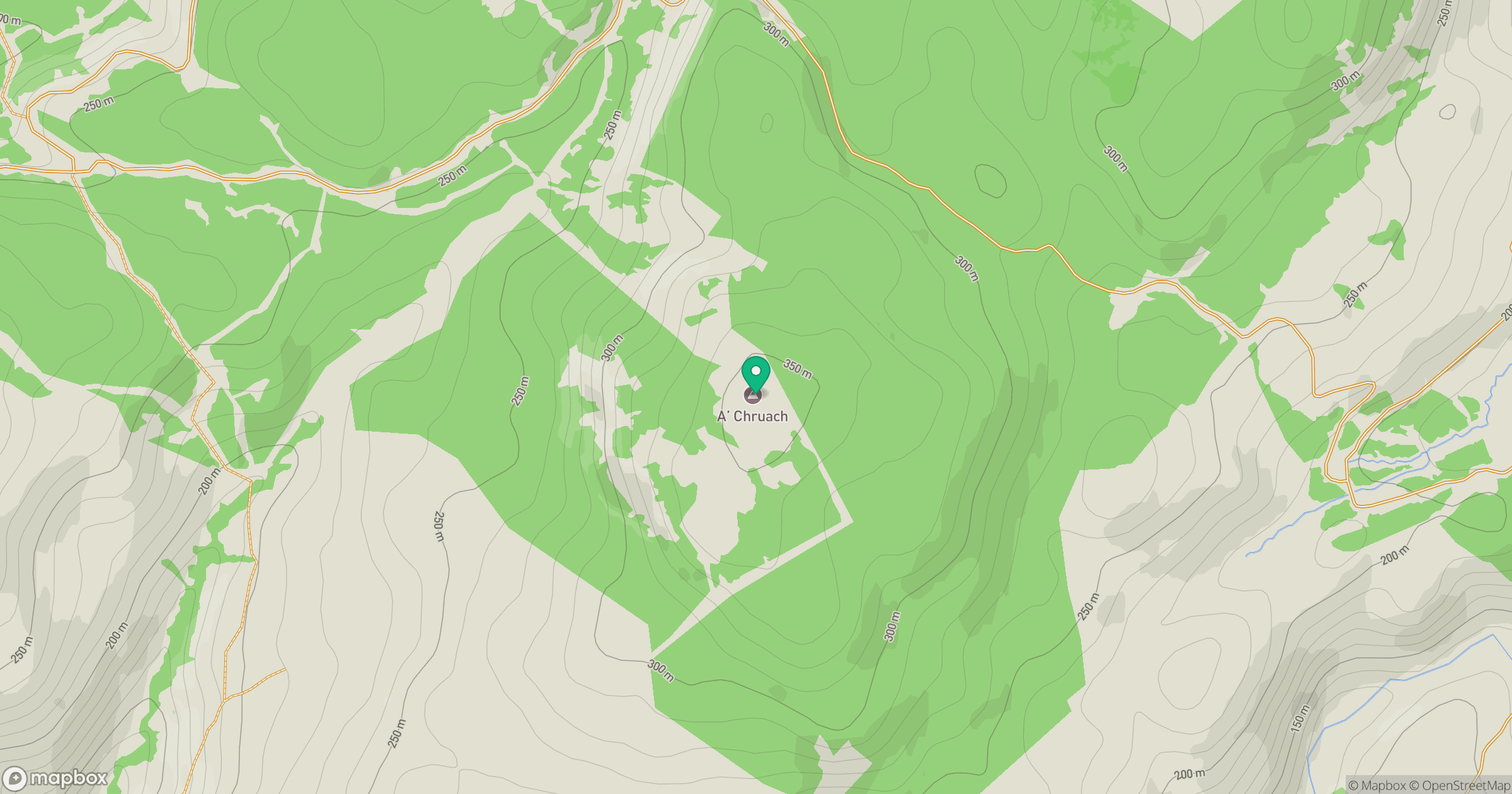
Grid reference: NM903218
View on OpenStreetMapOpens a map in a new tab, centred on the hill.
No comments yet. Be the first.