

Stob Poite Coire Ardair
Good walks are even better shared.
NN4288 : The summit of Stob Poite Coire Ardair
Nigel Brown Photo source
Overview
Stob Poite Coire Ardair
Stob Poite Coire Ardair, standing proudly at 999 meters, is a celebrated Munro in the heart of the Scottish Highlands. This majestic peak, while not the tallest, offers both challenge and spectacular vistas that capture the essence of Scotland's rugged beauty.
Geology
The bedrock of Stob Poite Coire Ardair is predominantly granitic, which has weathered over time to form the unique terrain we see today. Expect rocky paths that may test your footing, especially in the wettest of Scottish weather!
Routes
The most popular route to the summit is via the Coire Ardair Route, starting from the well-known car park near Aberfeldy. At 8.5 km in length, this moderate hike will take you roughly 4 hours, depending on your pace and how often you stop to admire the views.
Summit Features
Once you reach the summit, greeted by a sturdy stone cairn, you’ll be treated to some of the best panoramic views in Scotland. Take a moment to refill your lungs with fresh mountain air before resuming your descent.
Terrain
The terrain is a mix of rocky ground and soft grass, interspersed with occasional boggy sections that remind you of Scotland's unique ecosystem. Be prepared for a mix of walking conditions!
Views
The views from Stob Poite Coire Ardair are nothing short of breathtaking. Clear days offer a glimpse of Ben Nevis, while the shimmering waters of Loch Ness beckon in the distance. The best times to appreciate these views are in spring or autumn when the colours of the landscape are most vivid.
Hazards
As with any mountain adventure, take heed of the changing weather conditions. The weather can shift faster than you can say 'Scotch whisky,' so pack layers and always have a plan for unexpected rain. Watch your footing on those rocky trails, particularly in damp conditions.
Nearby Summits
If you're feeling adventurous, consider tackling the neighbouring summits, such as Stob Coire an Dèirg (962 m) and Carn Liath (1036 m), both of which are well worth the effort and can easily be added to your hiking itinerary.
Access
Nearest Parking
The nearest car park at NN 423 883 provides ample space for hikers to start their journey.
Public Transport
For those relying on public transport, be aware that buses from Fort William can take you to nearby villages. Just be sure to check the schedules, as timely transport is a bit temperamental!
Nearest Town
Aberfeldy, just a stone's throw away (approximately 10 km), is the closest town, boasting shops, cafes, and necessary amenities post-hike.
Facilities
Once you're done conquering the mountain, treat yourself to a slice of cake and a cup of tea at one of Aberfeldy's charming cafes, where weary walkers are more than welcome.
History
Name Meaning
The name Stob Poite Coire Ardair conjures images of steep hills and deep hollows, perfectly encapsulating the mountain’s design and its dramatic setting within the highlands.
Significance
This Munro holds a special place in the hearts of local hikers and climbers alike, symbolising not just a challenge, but the beauty and spirit of Scotland’s great outdoors.
In conclusion, Stob Poite Coire Ardair awaits with its picturesque views, challenging routes, and friendly atmosphere. Lace up those boots, and remember, there’s no such thing as bad weather, just inappropriate clothing!
Explore routes near Stob Poite Coire Ardair
Walks starting near this hill. Open a route to check its map, distance and full itinerary.
Fort Augustus to Kytra Lock: Caledonian Canal Towpath
View route
Banavie to Glen Loy Aqueduct: Neptune’s Staircase Canal Towpath
View route
Ben Nevis via Mountain Path
View route
Glen Affric: Coire Loch Woodland Trail
View route
Route planning notes
These notes describe possible approaches. Check a route's map and access information when planning your walk.
Coire Ardair Route
This popular route begins at the car park near the village of Aberfeldy, offering stunning views as you ascend towards the summit.
Make a day of it, together
Find someone to share the walk with, or organise a day out along a route you like.
Photo Gallery
View all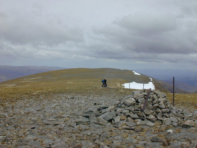 Photo could not load
NN4288 : The summit of Stob Poite Coire Ardair
Nigel Brown
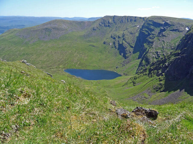 Photo could not load
NN4288 : Above Coire Ardair
Adam Ward
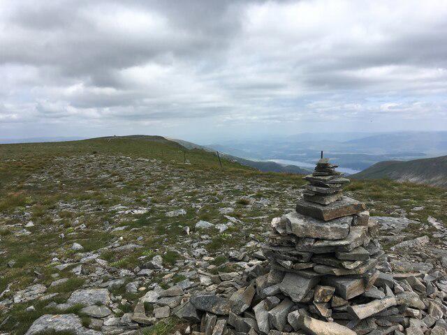 Photo could not load
NN4288 : Summit area of Stob Poite Coire Adair
Steven Brown
Hill facts and local notes
Classifications
Elevation
1,052m
3,453 ft
Prominence
107m
Coordinates
56.9640, -4.5858
NN428888
OS Map
34 42
Explorer: OL55 401
At the Summit
At the summit, you will find a stone cairn that offers a resting place as well as fantastic panoramic views.
Terrain & Geology
The mountain is primarily composed of granitic rock, providing a rugged terrain that showcases the power of geological forces at work over millennia.
Views & Scenery
From the summit, you can see Ben Nevis, the largest mountain in the UK, as well as the stunning Loch Ness in the distance.
History & Heritage
Name Origin
The name Stob Poite Coire Ardair roughly translates to 'summit of the hollow of the steep,' fitting for this towering peak.
Historical Significance
This mountain is cherished for its breathtaking landscapes and is a favourite among local hikers.
Getting There & Facilities
Parking
There is a car park at NN 423 883, which serves as a great starting point for your hike.
Public Transport
Regular buses run from Fort William to nearby villages, but check schedules as they can be a bit sparse.
Nearby Facilities
There are cafes and toilet facilities in Aberfeldy, as well as some lovely spots to grab a slice of cake post-hike.
Safety Information
Known Hazards
- Mountain weather can change rapidly; ensure you are prepared for all conditions. Beware of loose rocks and steep terrain.
General Safety Tips
- Check weather conditions before setting out
- Carry appropriate clothing and equipment
- Let someone know your planned route
- Take a map, compass, and GPS device
- Carry emergency supplies: food, water, first aid kit, torch
Hills
Some common questions about the hills answered
Are there group walks up Stob Poite Coire Ardair?
Many walkers use Walkmates to join or organise walks with others. You can check for group walks around Stob Poite Coire Ardair through the maps
Are there other walkers around Stob Poite Coire Ardair?
Activity varies by location and time, but Walkmates lets you see whether others have shared walks or shown interest in this area. Find other people through the walking friends search walking friends for Stob Poite Coire Ardair search or of course create your own walk for Stob Poite Coire Ardair
Can I organise a walk to Stob Poite Coire Ardair?
Yes. If there aren’t any walks listed already, you can create a walk and make it available for others to join.
If you're signed up to Walkmates, you can create a walk to Stob Poite Coire Ardair.
How do I find a walk up this hill?
There are often multiple ways to walk this hill, depending on experience and route preference. Walkmates helps you explore walks and routes that others have shared.
Can I suggest a new route up Stob Poite Coire Ardair?
Yes. You can suggest or create routes to share with others. Walkmates focuses on the social side of walking, so routes are used to help people organise walks and explore areas together, rather than as detailed navigation tools or route libraries.
Other uses really appreciate knowledgeable walkers sharing their routes. Share your favourite route to Stob Poite Coire Ardair here
The is an error or something incorrect about this hill. How do I let you know?
We always strive to keep the information on Walkmates as accurate as possible. If you find an error, please let us know through the contact form and we'll aim to correct it as quickly as possible
Community Discussion
Comments
Location
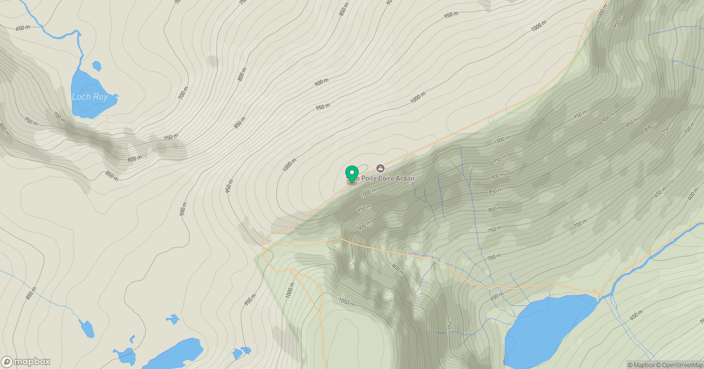
Grid reference: NN428888
View on OpenStreetMapOpens a map in a new tab, centred on the hill.
Nearby Hills
Creag Meagaidh
1,128m
Ben Alder
1,148m
Beinn Mheadhoin
541m
Stob Ban
977m
Stob Choire Claurigh
1,177m
No comments yet. Be the first.