

Sgorr Bhogachain
Good walks are even better shared.
Overview
Sgorr Bhogachain: The Undiscovered Gem of the Scottish Highlands
Sgorr Bhogachain stands proudly at an elevation of 852 meters, marking its territory in the exquisite Scottish Highlands. With its striking volcanic geology, this Munro invites hikers and nature enthusiasts alike to wander its grassy slopes and rocky outcrops.
Getting There
To start your adventure, head to the small village of Inversnaid. It’s a place where you might be inclined to linger a bit longer, with stunning views of Loch Lomond. The standard route from Inversnaid offers a moderate trek of about 8.0 km, which takes approximately 4.5 hours to complete. Don’t forget to pack a picnic; the summit begs for a leisurely lunch!
Summit Features
At the summit, adventurers are welcomed by a sturdy cairn, perfect for snapping that coveted summit selfie. Settle in and soak up those panoramic vistas, where Ben Lomond appears to give a cheeky wave and the vast Trossachs roll into the distance.
Terrain and Hazards
The terrain primarily consists of grassy slopes combined with rocky outcrops. Be prepared for the occasional boggy patch—waterproof boots are advised unless you enjoy a good squelch. Keep an eye on the skies; the Highlands love to gift hikers with sudden weather changes. When in doubt, it's better to layer up!
Views and Best Seasons
So, when's the best time to indulge in these vistas? Late spring or early autumn are your best bets for ideal hiking conditions and clear views. The sight of lush greenery framed by autumn leaves or vibrant spring flowers is simply unbeatable.
Facilities and Access
You’ll find parking available at Inversnaid (NR432029), though it’s limited, so early birds catch the worm! Balloch is the nearest town, where you can find public transport options to reach Inversnaid.
For facilities, there’s a lovely hotel nearby where you can grab a meal and take a well-deserved break after your expedition.
History
As for the name, Sgorr Bhogachain means 'the rounded peak of the bog'—a fitting descriptor that’ll make you chuckle as you step over the squishy bits! Historically rich, this area is steeped in clan folklore and offers a connection to the past that's as enduring as the hills themselves.
So lace up your boots and chart your course. Sgorr Bhogachain is waiting to reveal its secrets!
Happy Hiking!
Explore routes near Sgorr Bhogachain
Public walks starting within 80 km of this hill. Nearby does not mean a route reaches the summit; check its map and access before setting out.
Crinan Canal: Bellanoch and Dunardry towpath return
View route
Portballintrae to Giant's Causeway: railway path and Blue Trail return
View route
Goatfell from Cladach
View route
Bishop’s Glen group walk
View route
Route planning notes
These notes describe possible approaches, not verified navigable routes or permission to cross land. Check current paths, local access rules and conditions before setting out.
The Standard Route from Inversnaid
A scenic ascent with breathtaking views, starting from the picturesque village of Inversnaid.
Make a day of it, together
Find someone to share the walk with, or organise a day out along a route you like.
Photo Gallery
View all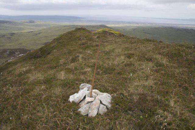 Photo could not load
NR4051 : Summit of The Sgurr, Islay
Becky Williamson
Hill facts and local notes
Classifications
Elevation
374m
1,227 ft
Prominence
133m
Coordinates
55.6876, -6.1373
NR400515
OS Map
60
Explorer: 352
At the Summit
At the summit, you'll find a sizable cairn which provides an excellent viewpoint for those seeking a moment of zen or simply a place to rest their weary legs.
Terrain & Geology
Sgorr Bhogachain is primarily composed of volcanic rock, a testament to the ancient geological activity in this region, offering fascinating formations and textures everywhere you tread.
Views & Scenery
On a clear day, the summit offers stunning views over Loch Lomond and the surrounding hills, including Ben Lomond and the wild expanse of the Trossachs.
History & Heritage
Name Origin
The name Sgorr Bhogachain translates to 'the rounded peak of the bog'. Quite apt, considering the occasional squelch underfoot!
Historical Significance
Historically, this area has been an important site for local clans and is rich in folklore.
Getting There & Facilities
Check current local access restrictions, parking rules and transport timetables before travelling. These notes do not confirm public access to the summit.
Parking
There is a small car park at Inversnaid (NR432029) with limited spaces. Arrive early to avoid disappointment!
Public Transport
Accessible via bus services from Glasgow to Inversnaid. Check the latest schedules as they can change with the seasons.
Nearby Facilities
You can find basic facilities such as toilets at Inversnaid, and there’s a charming hotel where you can grab a bite to eat before or after your hike.
Safety Information
Known Hazards
- Watch out for sudden weather changes; conditions can shift faster than you can say 'wish I had brought a jacket!'
General Safety Tips
- Check weather conditions before setting out
- Carry appropriate clothing and equipment
- Let someone know your planned route
- Take a map, compass, and GPS device
- Carry emergency supplies: food, water, first aid kit, torch
Hills
Some common questions about the hills answered
Are there group walks up Sgorr Bhogachain?
Many walkers use Walkmates to join or organise walks with others. You can check for group walks around Sgorr Bhogachain through the maps
Are there other walkers around Sgorr Bhogachain?
Activity varies by location and time, but Walkmates lets you see whether others have shared walks or shown interest in this area. Find other people through the walking friends search walking friends for Sgorr Bhogachain search or of course create your own walk for Sgorr Bhogachain
Can I organise a walk to Sgorr Bhogachain?
Yes. If there aren’t any walks listed already, you can create a walk and make it available for others to join.
If you're signed up to Walkmates, you can create a walk to Sgorr Bhogachain.
How do I find a walk up this hill?
There are often multiple ways to walk this hill, depending on experience and route preference. Walkmates helps you explore walks and routes that others have shared.
Can I suggest a new route up Sgorr Bhogachain?
Yes. You can suggest or create routes to share with others. Walkmates focuses on the social side of walking, so routes are used to help people organise walks and explore areas together, rather than as detailed navigation tools or route libraries.
Other uses really appreciate knowledgeable walkers sharing their routes. Share your favourite route to Sgorr Bhogachain here
The is an error or something incorrect about this hill. How do I let you know?
We always strive to keep the information on Walkmates as accurate as possible. If you find an error, please let us know through the contact form and we'll aim to correct it as quickly as possible
Community Discussion
Comments
Location
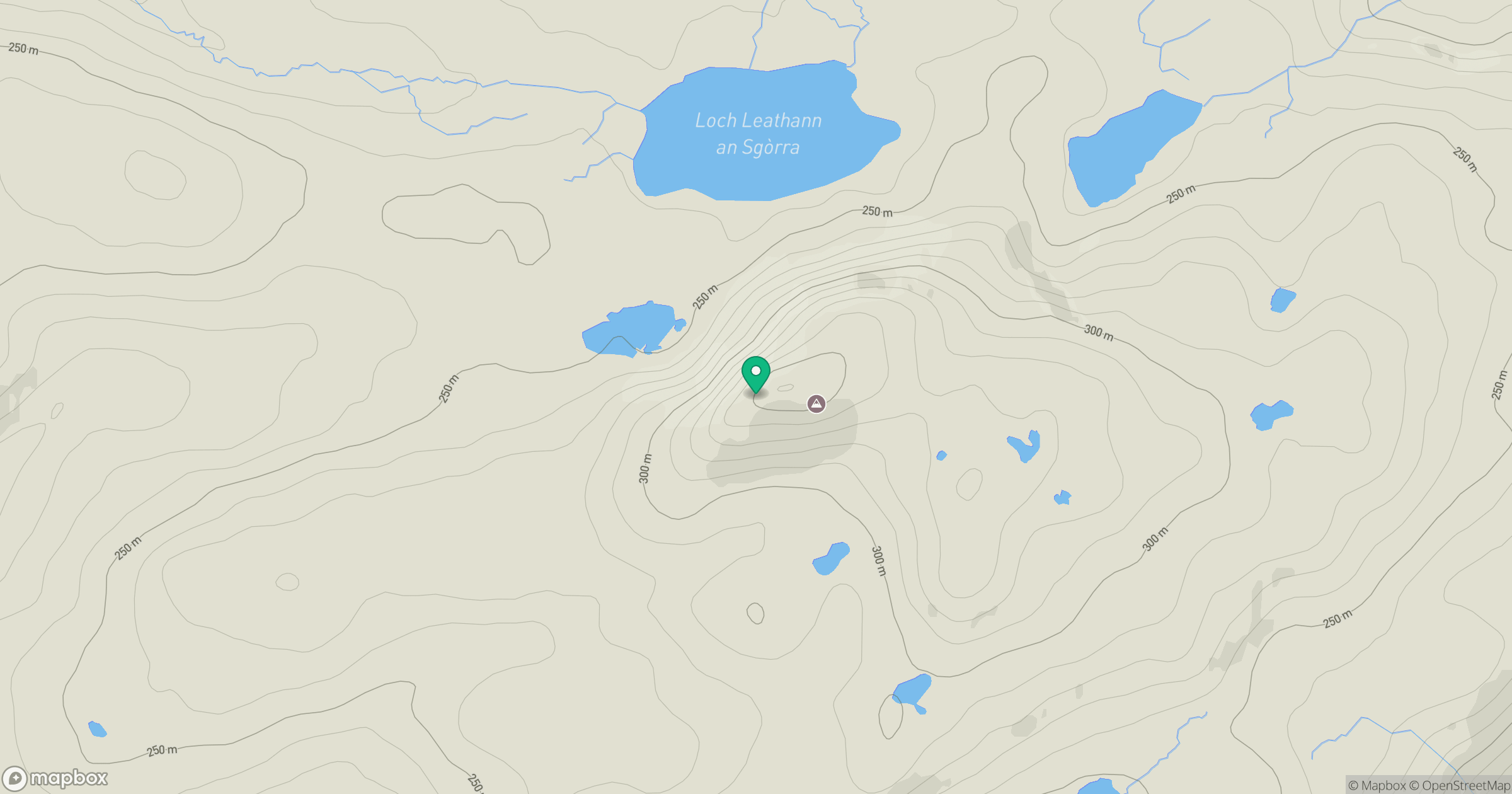
Grid reference: NR400515
View on OpenStreetMapOpens a map in a new tab, centred on the hill.
Hills within 30 km
Straight-line distance, not a walking route or confirmation of access.
No comments yet. Be the first.