
Dubh Bheinn
Good walks are even better shared.
Overview
Dubh Bheinn
Dubh Bheinn, standing proudly at 958 meters, is a beloved Munro in the heart of the Scottish Highlands. Known for its rugged terrain and breathtaking vistas, it attracts hikers from all walks of life—some searching for a quiet day in the hills, others on a quest for the perfect Instagram shot.
Geology
The mountain's slopes are crafted from schist and quartzite, showcasing the stunning effects of metamorphic processes. Glacial activity has shaped not only Dubh Bheinn but the entire region, leaving behind a landscape that seems to be a masterpiece of nature itself.
Access
For those keen on reaching Dubh Bheinn, the nearest parking is conveniently located at the West Highland Way trailhead in Tarbet. From here, the routes leading to the summit are well-marked, although a good sense of direction and perhaps a map wouldn't go amiss. Public transport options include buses from Glasgow that make the trip to Tarbet easy for those without a car.
Facilities
Post-adventure, Arrochar boasts a few cafes and pubs perfect for a well-deserved pint or slice of cake. Just remember, the mountain won't judge if you treat yourself after a long hike!
Routes
- West Highland Way Approach: This route spans about 16 km and is considered moderate in difficulty. It's an excellent choice for those looking to soak in the local scenery with added company along the popular trail.
- From Inveruglas: A more challenging path at about 12 km, it offers a quieter experience and stunning vistas, but be prepared for a bit of legwork!
Summit Features
Upon reaching the summit, hikers are greeted by a sturdy stone cairn—a humble monument to all who have scaled these heights. The views? Absolutely breathtaking. On clear days, the sights stretch over Loch Long and the stunning Arrochar mountains, a painter's palette of greens and blues.
Hazards
While the mountain is a treat, it does come with its dangers. Loose stones and steep drop-offs require caution, and remember, when in the Highlands, be prepared for sunshine, rain, and perhaps a bit of both!
In conclusion, Dubh Bheinn promises adventure and stunning sights in equal measure. With the right preparation, it can be a rewarding day out in the wild, perfect for both seasoned hikers and those just wanting to escape the daily grind. Don't forget to enjoy the views—after all, that's what we're here for!
Explore routes near Dubh Bheinn
Public walks starting within 80 km of this hill. Nearby does not mean a route reaches the summit; check its map and access before setting out.
Crinan Canal: Bellanoch and Dunardry towpath return
View route
Goatfell from Cladach
View route
Glen Kin group walk
View route
Bishop’s Glen group walk
View route
Route planning notes
These notes describe possible approaches, not verified navigable routes or permission to cross land. Check current paths, local access rules and conditions before setting out.
West Highland Way Approach
A popular and scenic route from Memoires of a Highland Walk that features varied terrain and breathtaking views.
From Inveruglas
A slightly less travelled path that gives a more tranquil approach to the summit, traversing beautiful glens and offering a closer look at local wildlife.
Make a day of it, together
Find someone to share the walk with, or organise a day out along a route you like.
Hill facts and local notes
Classifications
Elevation
530m
1,739 ft
Prominence
137m
Coordinates
55.8424, -6.0116
NR489683
OS Map
60 61
Explorer: 355S
At the Summit
The summit features a stone cairn and provides panoramic views of the surrounding landscape. The rewarding vista includes Loch Long and the Arrochar Alps.
Terrain & Geology
Primarily composed of metamorphic rocks, primarily schist and quartzite, Dubh Bheinn offers a stunning example of the geological processes that formed the Highlands over millions of years. Its rugged terrain is the result of glacial activity, making for a dramatic landscape.
Views & Scenery
From the summit, you can gaze upon Loch Long, the rugged peaks of the Arrochar Alps, and the expansive valleys below. On a clear day, distant views of the Isle of Arran are also possible.
History & Heritage
Name Origin
The name 'Dubh Bheinn' translates to 'black mountain' in Gaelic, likely referring to the mountain's dark, imposing appearance, especially when seen from a distance.
Historical Significance
Dubh Bheinn has been loved by hikers for its challenging routes and stunning views, making it a prominent feature in hiking literature.
Getting There & Facilities
Check current local access restrictions, parking rules and transport timetables before travelling. These notes do not confirm public access to the summit.
Parking
There is parking available at the start of the West Highland Way near Tarbet, which is approximately a 10-minute drive from Dubh Bheinn's trailhead.
Public Transport
Regular bus services run from Glasgow to Tarbet, making it fairly accessible for those reliant on public transport.
Nearby Facilities
There are a few local cafes and pubs in Arrochar where hikers can refuel after their adventure. Toilets are typically available at the village but may not be on the trails themselves.
Safety Information
Known Hazards
- Steep slopes and loose stones can pose a risk of falling. Weather can change rapidly, so be prepared for all conditions.
General Safety Tips
- Check weather conditions before setting out
- Carry appropriate clothing and equipment
- Let someone know your planned route
- Take a map, compass, and GPS device
- Carry emergency supplies: food, water, first aid kit, torch
Hills
Some common questions about the hills answered
Are there group walks up Dubh Bheinn?
Many walkers use Walkmates to join or organise walks with others. You can check for group walks around Dubh Bheinn through the maps
Are there other walkers around Dubh Bheinn?
Activity varies by location and time, but Walkmates lets you see whether others have shared walks or shown interest in this area. Find other people through the walking friends search walking friends for Dubh Bheinn search or of course create your own walk for Dubh Bheinn
Can I organise a walk to Dubh Bheinn?
Yes. If there aren’t any walks listed already, you can create a walk and make it available for others to join.
If you're signed up to Walkmates, you can create a walk to Dubh Bheinn.
How do I find a walk up this hill?
There are often multiple ways to walk this hill, depending on experience and route preference. Walkmates helps you explore walks and routes that others have shared.
Can I suggest a new route up Dubh Bheinn?
Yes. You can suggest or create routes to share with others. Walkmates focuses on the social side of walking, so routes are used to help people organise walks and explore areas together, rather than as detailed navigation tools or route libraries.
Other uses really appreciate knowledgeable walkers sharing their routes. Share your favourite route to Dubh Bheinn here
The is an error or something incorrect about this hill. How do I let you know?
We always strive to keep the information on Walkmates as accurate as possible. If you find an error, please let us know through the contact form and we'll aim to correct it as quickly as possible
Community Discussion
Comments
Location
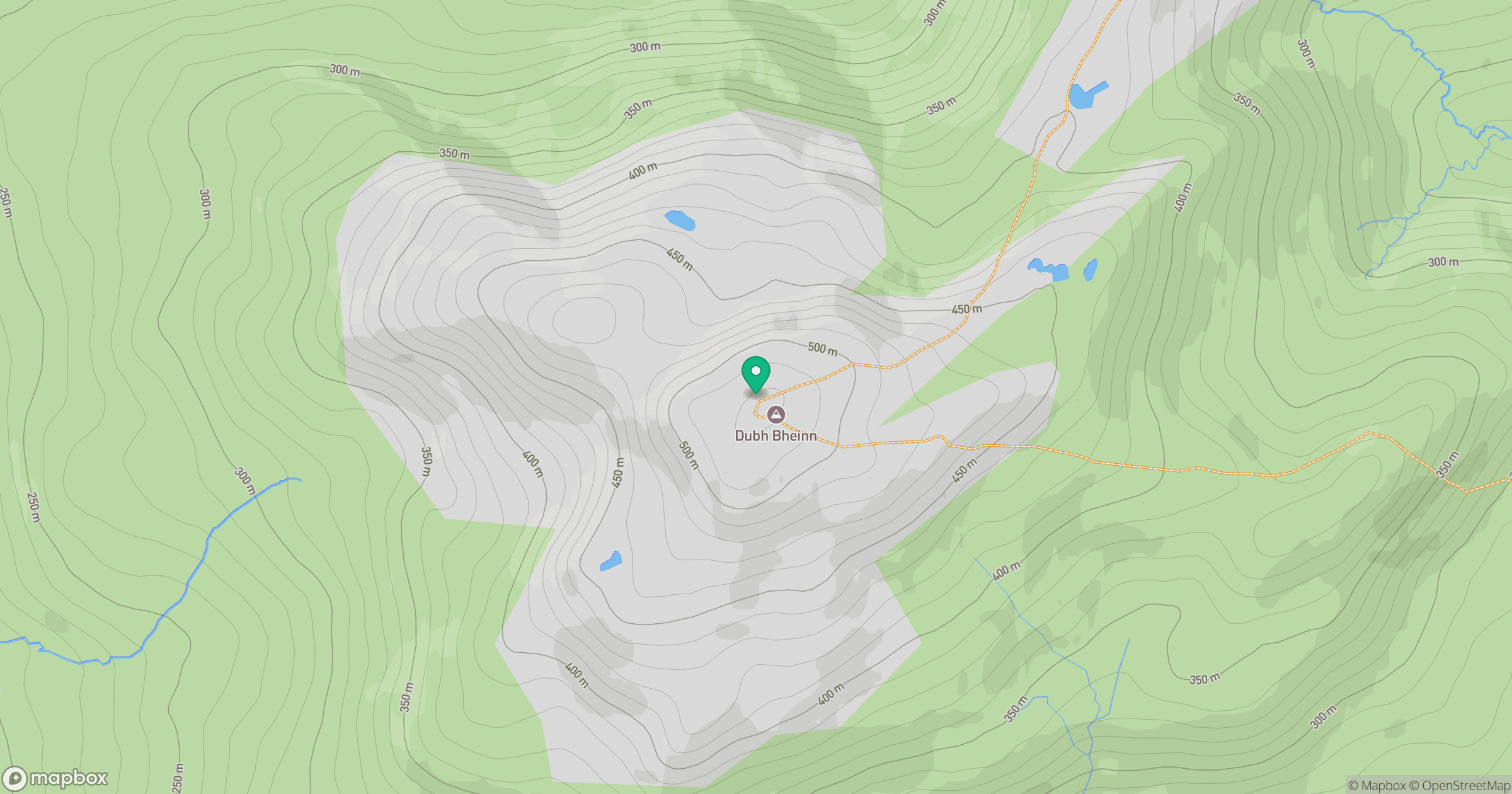
Grid reference: NR489683
View on OpenStreetMapOpens a map in a new tab, centred on the hill.
Hills within 30 km
Straight-line distance, not a walking route or confirmation of access.
No comments yet. Be the first.